
Incident Publication
Lava Fire Daily Update September 23 2024 09 23 2024
Related Incident:
Publication Type: News
A Community Meeting will be held in Indian Valley on Tuesday, September 24th at 7:00 p.m. at the Indian Valley Community Hall, 803 Indian Valley Road, Indian Valley, Idaho.
As a reminder, on the Boise National Forest, Snowbank Road and the Sage Hen Reservoir area remain closed. In Gem County, the following roads are closed: Third Fork Road at Nesbitt Lane, Second Fork Road at Nesbitt Lane, and Nesbitt Lane. The Sweet-Ola Highway is closed at the High Valley intersection in Ola. Please be advised that the Gem County Sheriff’s Office is staffing the road closure check points.
The Rocky Mountain Complex Incident Management Team 2 is arriving to transition with the Southern Area Read Team. The Rocky Mountain Team will join command of the fire on Wednesday, September 25th.
Overview: The Lava Fire is on the Boise and Payette National Forests and lands administered by the Bureau of Land Management and the Idaho Department of Lands. The fire is located north of Emmett and west of Lake Cascade and started by lightning on Monday, September 2. It is burning in tall grass, brush, and timber.
The Lava Fire is currently 97,844 acres with 65 percent of the perimeter contained. 658 personnel are assigned, including 13 crews, 1 large helicopter, 1 small helicopter, 25 engines, 9 bulldozers, 13 water tenders, 7 excavators, 1 skidder, 8 masticators, 4 graders, and 7 ambulances.
Property remaining in an area that is evacuated or impacted by Forest Service closures must remain until fire managers, Sheriff’s departments, and emergency management departments deem the area is safe for reentry.
Operations: Yesterday, a new fire start was identified south of the West Mountain Complex Incident Command Post located south of Cascade, Idaho. Lava Fire air and ground resources assisted with initial attack, in collaboration with Idaho Department of Lands, Southern Idaho Timber Protective Association, and the Boise and Payette National forests.
On the eastern flank, repair of handline and dozer line continued. Crews repaired most of the dozer line in the southeastern portion the fire and conducted mop of heat within 150 feet of containment lines.
Hand crewscontinued building containment line directly along the fire edge in the northern flank from Little Weiser River working east and to Anderson Creek and working west from Forest Service Roads 835 to 766. Mop up continued around homes near Grays Creek and within 50 feet of containment lines.
On the western flank, mop up and suppression repair of interior dozer lines continued. Firefighters removed 10,000 feet of hoseline.
Firefighters continued constructing direct and indirect line along Forest Service Road 653 on the southern flank. Near the Gross community, crews continued mop and patrol 150 feet from containment lines.
Today, firefighters will continue to extinguish isolated pockets of heat, focusing on a depth of 150 feet from containment lines. Suppression repair work on containment lines as well as interior bulldozer lines will continue.
On the eastern flank, chipping will reduce thick, burnable vegetation on Forest Service Roads 446E and Gopher Road. Crews will patrol Forest Service Road 404 and extinguish any heat sources they find, focusing on a depth of 150 feet from the line. Firefighters will repair handlines and bulldozer lines, remove equipment, and assess equipment needs such as road repair graders.
On the northern flank, crews continue to build direct handline southwest along the fire edge towards Anderson Creek and mop up will continue as needed. On Forest Service Road 206, crews will remove hazard trees.
On the western flank, crews will extinguish heat along containment lines from Forest Service Road 208 to road 214. Firefighters will continue to repair containment line and interior bulldozer lines.
On the southern flank, firefighters will continue to patrol and mop up any fire activity near the Gross community. Chipping will occur on National Forest Road 625 and at the Third Fork Cabin. Hand crews will continue identifying heat and improving hand line along Forest Service Road 653.
Weather/Fire Behavior: Fair conditions continue. Cloud cover from the weak weather system that came into the area on Sunday is expected to clear throughout the day. As cloud cover reduces, temperatures are expected to increase to the upper 60s or low 70s. As the system departs, winds may pick up to 5 to 9 mph with gusts up to 18 mph. In the next several days, temperatures are expected to rise and with it the potential for fire spread including single tree torching.
Evacuations: Adams County Sheriff’s Office downgraded to a Level 1 “READY” for residents south of South Grays Creek, along Little Weiser River Road in Indian Valley, North of South Grays Creek Road to Highway 95, and the Mesa Area.
Valley County Sheriff’s Office removed Zones 2 & 3 from LEVEL 1 “READY” status. Zones 4 – 6 remain in a LEVEL 1 “READY” Evacuation notice.
Closures and Restrictions: The Boise and Payette National Forests implemented a joint Lava Fire Area, Road, and Trail Closure for public and firefighter safety. The southern portion of this closure area follows roads 601 (which remains closed) and 644 (which remains open). The northern boundary follows a portion of the Payette National Forest’s road 186 (open) and crosses over to the Boise National Forest just south of trail 116. Snowbank Road (446) and Sage Hen Reservoir area remain closed, French Creek Campground remains open. This closure adjustment became effective on September 19, 2024, at 10:00 a.m.
Gem County Road and Bridge issued the following road closures: Third Fork Road at Nesbitt Lane, Second Fork Road at Nesbitt Lane, and Nesbitt Lane. The Sweet-Ola Highway is closed at the High Valley intersection in Ola. Please be advised that the Gem County Sheriff’s Office is staffing the road closure check points.
A temporary flight restriction is in effect in and around the fire area. This includes the use of personal drones. If you fly, we cannot fly.
Middle Fork Complex Daily Update Sept 23 2024 09 23 2024
Related Incident:
Publication Type: News
![]() Middle Fork Complex Fire Update
Middle Fork Complex Fire Update ![]() September 23, 2024
September 23, 2024
Middle Fork Complex: 61,484 acres, 85% completion, 572 Personnel
Snag Fire: 33,300 acres, 78% completion, 175 Personnel
Goat Fire: 26,476 acres 32% completion, 89 personnel
Today, we are seeing warmer and dryer weather trends, with increased winds forecasted for the middle of the week. Fire activity is not expected to increase today. Available finer fuels will continue to dry, especially in the lower elevation areas.
Middle Fork Complex – Today firefighters continue to implement fire line near Deadwood Reservoir near the 582 road. They are also masticating and chipping along the northern section of the 555 road to finish clearing debris within the fuel breaks. These shaded fuel breaks are intended to stop the fire from spreading regardless of the direction it came from.
Goat – Firefighters are continuing to construct line on the west side of the fire to protect private lands. They are also continuing to remove equipment and repair firelines.
Snag – Firefighters continuing to secure the fires edge, north of the Warm Lake highway. Fire personnel will continue to identify equipment and machinery that can be removed or relocated to areas in need. On the east side of the fire, natural barriers and the old burns will continue to help minimize fire growth within the identified confinement area.
Middle Fork Complex = 31 miles of handline completed. 25 miles of dozer line completed.
Goat and Snag Fires = 16.9 miles of handline completed. 25.9 miles of dozer line completed.
The public are reminded that heavy fire equipment and support vehicle traffic can be expected along all open roadways. Please use extreme caution while traveling, especially when approaching vehicles, and at intersections.
Closure Orders: https://www.fs.usda.gov/alerts/boise/alerts-notices
Hunters are not allowed access to closed areas. We ask the public to adhere to the closures as they currently exist; in particular, Trail Creek Hot Springs is currently within the closure area for the West Mountain Complex and is closed.
Fire Restrictions: Stage 1 Fire Restrictions have been rescinded for the Boise National Forest. For more information on the restrictions visit https://www.fs.usda.gov/alerts/boise/alerts-notices.
Middle Fork Fire Information: 208-992-3045 (8 a.m. – 8 p.m.)
Email: 2024.middleforkcomplex@firenet.gov
Inciweb: https://inciweb.wildfire.gov/incident-information/idbof-middle-fork-complex-fire-bulldog-and-nellie
Facebook: https://www.facebook.com/people/Middle-Fork-Complex-Fire-Boise-National-Forest/61565022204468 YouTube: https://www.youtube.com/@2024.middleforkcomplex
Red Rock and Black Eagle Fire Update 09 23 2024
Related Incident:
Publication Type: News
FIRE ACTIVITY:
The Red Rock Fire is at 3,080 acres and 54% containment.
Yesterday, containment continued to grow significantly despite active fire behavior in the area surrounding Red Rock Peak. This area, characterized by heavy fuels, steep terrain, and conditions favorable for fire growth, has been the most active part of the fire. While crews successfully built a direct line north of Red Rock Peak, rising temperatures in the afternoon caused the fire to spread west of the 110 road, and resources were shifted to contain that growth.
Today's main goal is to keep the fire within its current boundaries, especially monitoring areas like the section south of Fourth of July Creek, where handline construction is still needed. Efforts to protect the 110 road and construct a handline north of Red Rock Peak will continue today. Fire crews also made notable strides in repairing and clearing roadways impacted by fire operations yesterday, and they will maintain these efforts today.
The Black Eagle fire is at 6,475 acres and 7% containment.
Yesterday, the northeastern edge of the Black Eagle Fire saw some increased activity, but most of it was in the wilderness area. Crews are working on hotspots along the southeast side of the fire near Black Eagle Creek and Black Eagle Mine. They’re establishing direct lines and removing hazardous trees along nearby roads.
Today, this work will continue, with more tree removal planned along the 60112 road. Crews will also focus on securing spot fires to the east and west of Black Eagle Creek and will work on mopping up spot fires on both sides of the creek.
WEATHER:
Today’s weather is predicted to be similar to yesterday’s, with temperatures hitting the low 60’s, slightly stronger winds out of the NW at around 10mph (with gusts up to 20mph), and increased cloud cover bringing higher humidity (between 32%-53%) to the area.
FIRE BEHAVIOR:
As the warming and drying trend continues, most of the forest’s fuels are becoming more available to burn. Therefore, fire behavior is likely to increase over the next few days. Although large portions of the fire are either in areas unlikely to support growth or are already encircled by handlines, this increased fire activity will make direct attack more challenging in areas like Red Rock Peak that do not have those advantages, particularly in the afternoons when temperatures hit their peak. Air support - such as helicopter bucket drops - will become an increasingly essential part of the fire containment effort.
FOREST CLOSURES:
For forest closure information please go to: https://www.fs.usda.gov/alerts/scnf/alerts-notices
EVACUATIONS:
For evacuation information in Lemhi County regarding these fires please go to: Emergency Management Department | Lemhi County, ID (lemhicountyidaho.org).
This is the PIO map for the Red Rock and Black Eagle fires for 09-23-24
Final Swauk Creek Fire Update 09 22 2024
Related Incident:
Publication Type: News
Final - Swauk Creek Fire
September 22, 2024
Estimated size: 348 acres
Containment: 72%
Start Date/Time: 9/8/2024 at 3:54 PM
Area of Origin: Adjacent to Highway 97, 14 miles east of Cle Elum, WA
Cause: Human
Structures Damaged: 0
Final Update: As of 7:00 AM this morning, the Swauk Creek Fire was officially transferred to the Type 4 incident commanders from the Okanogan-Wenatchee National Forest - Cle Elum Ranger District and the WA Department of Natural Resources – Southeast Region.
Throughout today, resources will be on the fire continuing to improve containment lines, mop-up and patrol for hot spots. Weather will be favorable for accomplishing this work but will be hotter and drier. Winds are expected to be normal for the area.
At the time of transition, the Okanogan-Wenatchee National Forest continues to have area, road, and trail closures due to the Swauk Creek Fire. For a detailed list of closures, including a map of the closure area, please visit the Okanogan-Wenatchee National Forest Website at https://www.fs.usda.gov/alerts/okawen/alerts-notices/?aid=90533. There are currently no evacuations in place.
Today, the Southeast Washington Incident Management Team will be heading home to rest and prepare for the next assignment. Thank you to the community and the cooperators for your ongoing support during this incident.
Actualizacin diaria del incendio Whisky Creek 09 22 2024
Related Incident: Whisky Creek Fire
Publication Type: News
Tamaño Whisky Creek: 3,169 acres | Fecha de inicio: 20 de julio |Causa: De orígen humano |Contención 25%
Total de recursos: 72 | Equipos de obreros: 2 | Camiones de bomberos: 2 | Tanques de agua: 2 | Maquinarias pesadas:2
El incendio Whisky Creek se encuentra en un terreno escarpado y escabroso dentro del área de naturaleza Mark O. Hatfield en el Bosque Nacional Mt. Hood. Permanece dentro de las líneas de control a lo largo de los extremos sur y este. La huellas del incendio Eagle Creek continúan como barrera a lo largo de los extremos oeste y norte del incendio.
El fuego sigue ardiendo entre troncos grandes y agujas de pino secas. Ayer, el clima resultó en temperaturas más altas y vientos ligeros del este, pero los bomberos no vieron mucha más intensidad en el fuego. Se prevé que el día de hoy y mañana serán cálidos y soleados, la intensidad de los incendios seguirá mínima con poco crecimiento. Se podrá seguir viendo humo desde Hood River Valley y el Columbia Gorge.
Ayer, las cuadrillas terminaron de nivelar la carretera forestal 2820 y avanzaron mucho en nivelar la carretera forestal 2810. Se ha completado de reparar el sendero forestal 409B. Con la guía de los asesores de recursos, los bomberos comenzarán a reparar el helipuerto que se creó en el área de naturaleza sobre Rainy Lake durante el trabajo de extinción.
Esta será la última actualización diaria del incendio Whisky Creek. En el futuro se publicarán actualizaciones según sea necesario para informar al público sobre cambios en la intensidad de incendios y cierres. El personal de bomberos continuará patrullando y vigilando el incendio, extinguiendo focos de calor que amenazan las líneas de control donde puedan hacerlo de manera segura, y reparando los daños causados por el trabajo de extinción.
Cierres: Permanecen cierres de áreas en el Bosque Nacional Mt. Hood, el Área Escénica Nacional Columbia River Gorge y el condado de Hood River. A medida que se terminan de reparar las carreteras y senderos afectados por el incendio, los administradores de la agencia trabajarán con el personal de bomberos para reevaluar el área de cierre del incendio. Se establecen cierres para la seguridad del público y de los bomberos; La intrusión en un área de cierre puede interrumpir las actividades de extinción y reparación de incendios, poner en peligro vidas y propiedades, y puede resultar en multas. La información de cierre se encuentra en: https://linktr.ee/whisky_creek.2024.
Humo: Con la llegada de un clima más cálido y vientos ligeros del este en los próximos días, se espera que el incendio continuará produciendo humo de ligero a moderado. Basado en la mínima actividad del fuego en las últimas dos semanas, no se espera que el fuego se desplace fuera de su huella actual. Para ver el pronóstico de humo y seguridad, consulte: oregonsmoke.org.
Seguridad: El público juega un papel importante en prevenir el próximo incendio forestal; Tenga cuidado con todas las posibles fuentes de ignición. Para ver consejos de prevención, consulte: https://keeporegongreen.org.
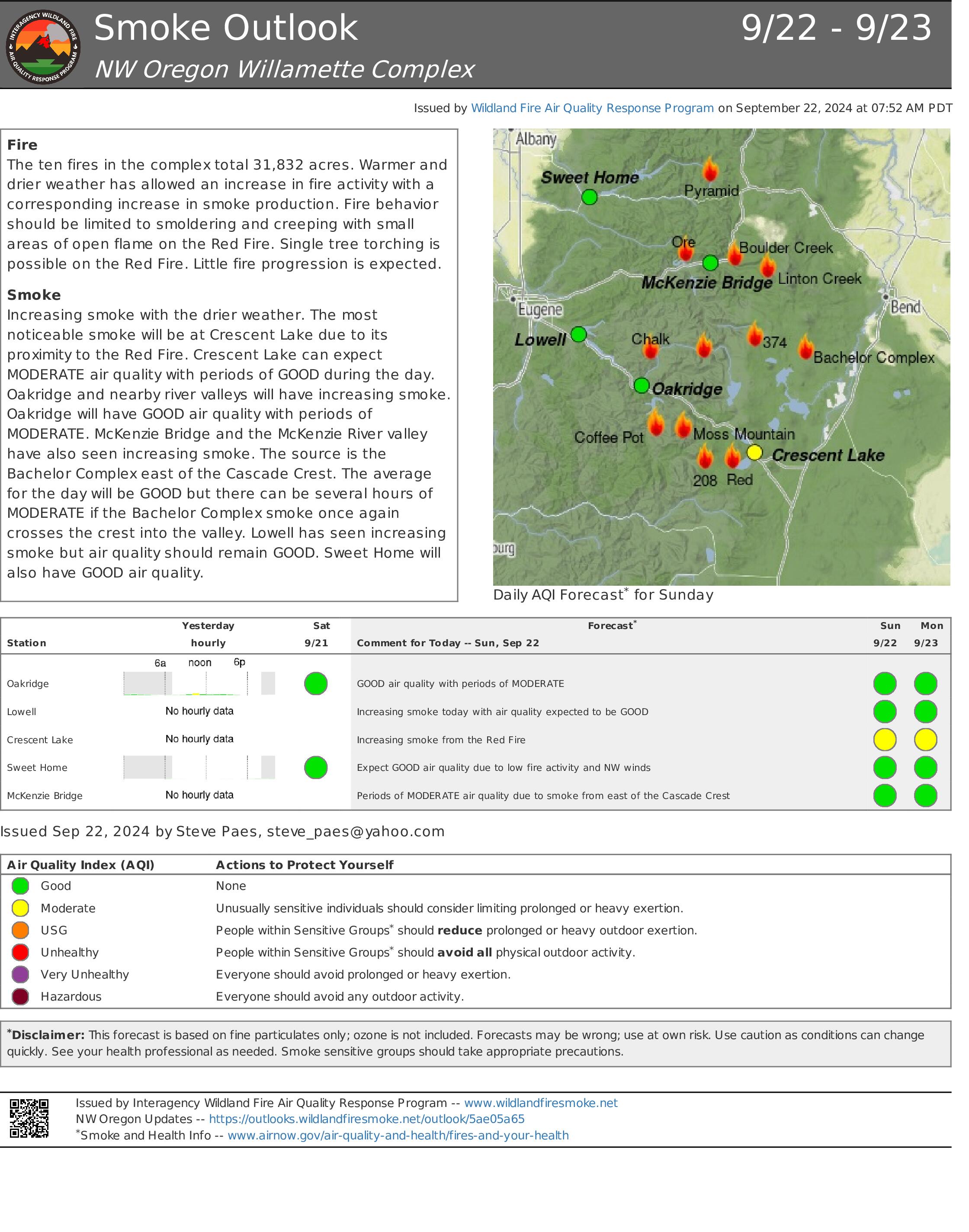
Red Fire Daily Update for Sunday 09 22 2024
Related Incident: Red Fire
Publication Type: News
Willamette Complex South & Red Fire Update
Red, 208, Moss Mountain, Coffee Pot, Tire Mountain, McKinley Creek and Chalk Fires
Date: Sunday, September 22, 2024
Fire Causes: Lightning
Email: 2024.willamettecomplex@firenet.gov
Information Phone Line: 541-208-1742
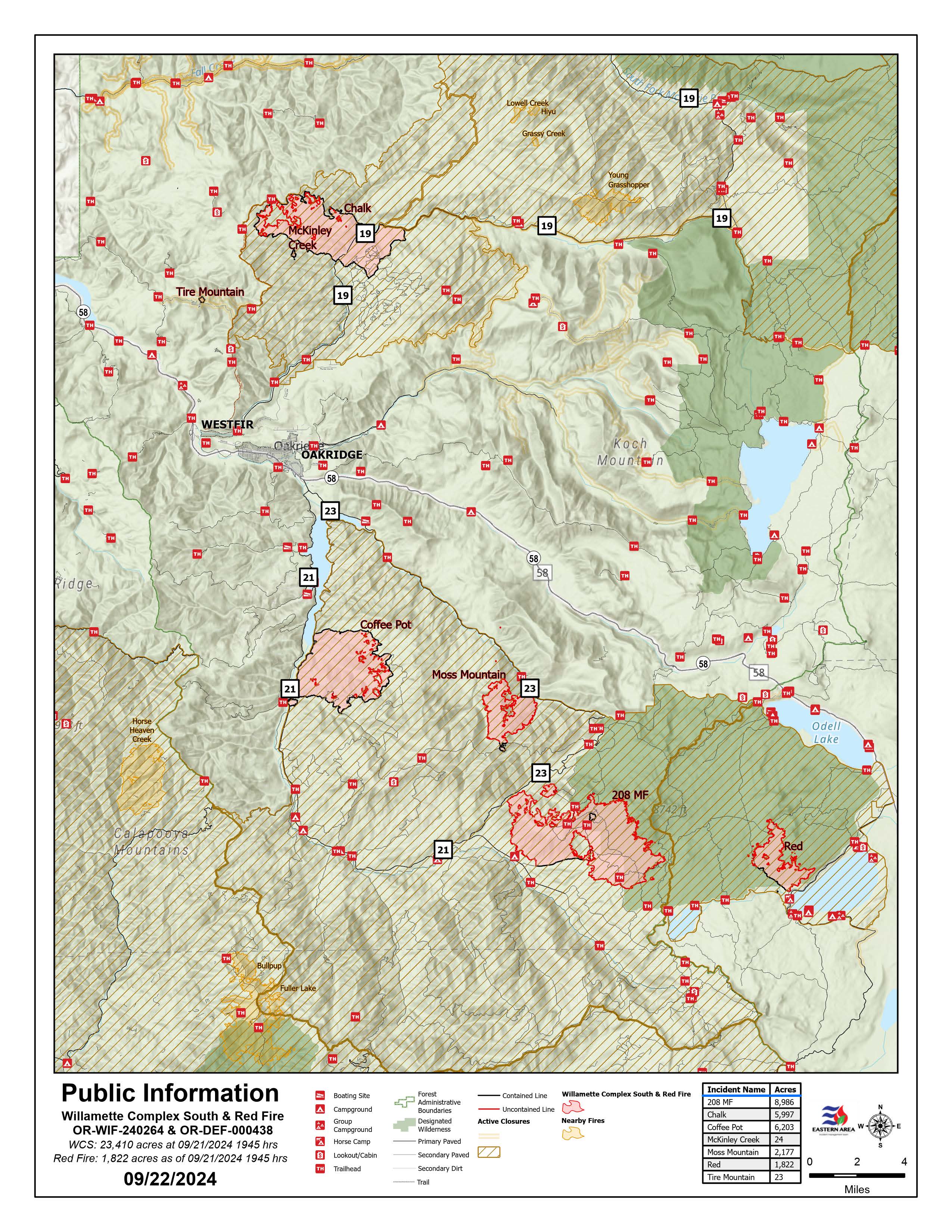
Willamette Complex South: Total Personnel: 414 | Total Willamette Complex South Acres: 23,400
InciWeb: https://inciweb.wildfire.gov/incident-information/orwif-willamette-complex-fires-south
Facebook: https://www.facebook.com/WillametteComplexFires/
Red Fire: Total Personnel: 50 | Total Red Fire Acres: 1,805
InciWeb: https://inciweb.wildfire.gov/incident-information/ordef-red-fire
Facebook: https://www.facebook.com/2024RedFireOR/
Summary
The Incident Management Team is assessing long-term strategies for the seven-fire complex. Much of that involves chipping, slash removal, road repair and bolstering containment lines. Fire growth has been minimal of late, but conditions are changing and that may affect fire behavior. Crews have been successful at keeping fire within established containment perimeters. Crews continue working to firm up indirect control lines and repair resources in places impacted by suppression operations. The situation at each fire will be closely monitored as we head into next week.
The Chalk Fire, Coffee Pot Fire, McKinley Creek Fire, and Tire Mountain Fire remain 100% contained and in monitor-and-patrol phase. There has been limited open flame and torching on the Chalk Fire. Crews are clearing brush and repairing roads used by fire crew vehicles and heavy equipment. Operations are designed to be scientifically sound and protect sensitive terrain and vegetation as much as possible. Resource specialists are assisting in plan development. Members of the public are asked to continue respecting area closures and restrictions which may change due to weather conditions and fire behavior. Forest leadership continue to evaluate and will adjust closures when it is safe to do so.
Red Fire (1,805 acres, 11% containment)
The Red Fire is 11% contained. Hauling and removal of slash from Forest Service Road (FSR) 6010 from Summit Lake to the southwestern corner of Crescent Lake remains a priority. Road repairs and clean-up of the shaded fuel break from Whitefish Horse Camp to Crescent Lake Sno-Park continues. Structure protection measures will remain in place, given the shift to warmer, drier weather. Fire growth remains minimal, moderately paced, and concentrated on the southeast perimeter of the fire. Additional fire crews are moving into the area with the anticipated warmer and drier air forecast for the next few days.
208 Fire (8,979 acres, 4% containment)
There were some puffs of smoke observed near the northwest corner. Crews will continue improving holding lines from Lighthouse Rock to Summit Lake. Road repair and material chipping operations are ongoing from Campers Flat to Emigrant Butte along FSR 21.
Moss Mountain Fire (2,175 acres, 10% containment)
Slash and excess vegetation removal along primary lines northeast of Groundhog Mountain is nearing completion, and some heavy equipment operations are being conducted there. Crews are making progress south of Beach Mountain near FSR 2316 and expect to connect to the existing fire-line along FSR 23 from the 208 Fire.
Weather and Fire Behavior
The passing cold front has run its course, so the brief boost in relative humidity is giving way to higher temperatures and a reduction in relative humidity levels. Temperatures are returning to seasonal averages, with lows in the 40s and highs in the mid-60s. Those temperatures may warm into the low 80s Tuesday or Wednesday with the arrival of another front. Expect light northwest winds and a drop in minimum relative humidity levels to 20 – 30%. Heavy fuels have been burning out, but smoldering and creeping continue.
Closures, Fire Restrictions, and Evacuations
- For closure information, visit: https://tinyurl.com/RedFireClosures2024 & https://tinyurl.com/WillFireClosures2024.
- For fire restrictions, visit: https://tinyurl.com/DesFireRestrictions2024 & https://tinyurl.com/WillFireRestrictions2024.
- The Level 1 – BE READY to Evacuate notice remains in effect for the Red Fire. For more information or to sign up for alerts, visit: www.klamathcounty.org/300/emergency-management.
Buck Creek Fire Update 09 22 2024
Related Incident: Buck Creek Fire
Publication Type: News
(Silver Lake, Ore.) – The Buck Creek Fire started in heavy timber within the Yamsay Mountain Semi-Primitive Area on the Fremont-Winema National Forest, about 13 miles southwest of Silver Lake, Ore. The fire spread north and east into managed timber stands on National Forest lands with brush and grass understory and remains about 11 miles from the community of Silver Lake. Increased smoke has been visible as warm and dry conditions produce more active fire behavior well inside the fire's perimeter. Containment has reached 84% and while fire line reinforcement continues, crews are also engaging in suppression repair.
As more areas reach containment, suppression repair begins on lines no longer needed to hold the fire. This is critical to minimizing the impact of soil erosion when rains arrive. Over 44 miles of line has been built using dozers and hand crews, and about 16 miles of road prepared to serve as fire line. Some of this line did not hold approaching fire during initial firefighting efforts and some was built as contingency line. Most of this line became containment features that have effectively limited fire spread. Where dozers were used to build fire line by clearing 10-foot-wide swaths down to mineral soil, repair efforts include using excavators to pull the berm of dirt and vegetation back into the line. Excavators also build water bars (dirt ridges used to divert water and minimize soil erosion) across constructed surfaces. Repair of hand line is similar, but crews use hand tools to build water bars and other mitigations. Along roadways, adjacent brush and trees are often cut and moved to the side when these features are prepared as fire line. At these locations, suppression repair includes chipping the cut vegetation and sometimes grading of the road surface. These repair efforts are designed to restore resilience to the landscape and mitigate damage that could result from future weather events.
Yesterday, a UAS (an Unstaffed Aerial System or drone) with infrared technology found no new hot spots. Chipping occurred on the west edge of the fire. The challenging mop up efforts in dense pockets of unburned fuels along the southern fire edge continued. Falling crews took down hazardous trees in several areas and road grading continued within the fire perimeter on Forest Roads 036 and 7645. Equipment backhaul was ongoing. Overnight, a crew patrolled the perimeter to ensure fire did not cross constructed fire lines.
Today, most activities will continue from the previous day. UAS missions will search for hot spots near the established fire line; crews will mop up and patrol to ensure the line remains secure. Equipment operators will work on restoring roads, completing suppression repair on dozer lines and chipping along roads used as fire line. Firefighters will continue backhauling. Helicopters are available to assist on-the-ground crews as needed.
Weather: The warming and drying trend is expected to continue through Tuesday. Light winds will be terrain driven with ridgetop gusts up to 15 mph.
Safety: Firefighting equipment and personnel are present on local roads. For the safety of firefighters and the public, fire managers ask the public to drive carefully and remain clear of the fire areas. The public also plays an important role in preventing the next wildfire by using caution with all ignition sources. For fire prevention tips, visit: https://keeporegongreen.org.
Closures and Restrictions: Fire danger remains high. Campfire and other restrictions are in place within the Fremont-Winema National Forest.A forest closure order is in effect for the area around the Buck Creek Fire. For the complete order and map as well as more detail on fire restrictions, go to: https://www.fs.usda.gov/fremont-winema. Christmas Valley Airport is being used as the helibase for fire operations and is temporarily closed to general aviation. A temporary flight restriction is in place over the Buck Creek Fire.
Smoke: Smoke from fires around the region may affect air quality. For more information on conditions and strategies on limiting exposure, go to: www.oregonsmoke.org or www.AirNow.gov.
Whisky Creek Fire update 09 22 2024
Related Incident: Whisky Creek Fire
Publication Type: News
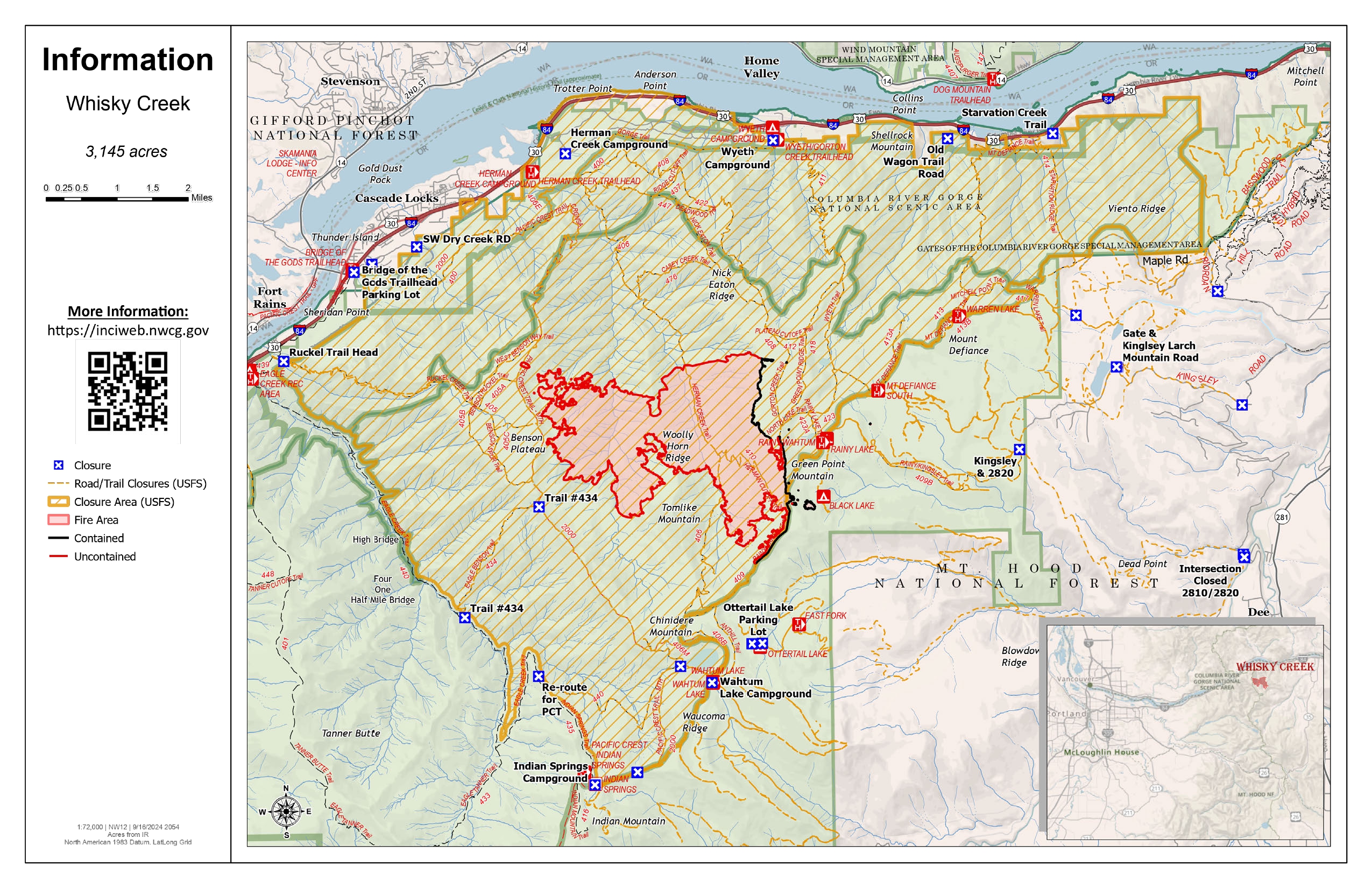
Whisky Creek Size: 3,169 acres | Start Date: July 20 | Cause: Human | Containment: 25%
Total Resources: 72 | Hand Crews: 2 | Engines: 2 | Water Tenders: 2 | Heavy Equipment:2
The Whisky Creek Fire is in steep and rugged terrain within the Mark O. Hatfield Wilderness in the Mt. Hood National Forest. The fire remains within the control lines along the southern and eastern edge. The Eagle Creek Fire scar continues to be a barrier along the western and northern edges of the fire.
The fire continues smoldering in needle-cast and heavy logs. Yesterday’s weather provided higher temperatures and light easterly winds, but firefighters did not see a significant increase in fire activity. Today and tomorrow are also predicted to be warm and sunny, but fire activity is anticipated to remain minimal with little growth. Smoke will continue to be seen from Hood River Valley and the Columbia Gorge.
Yesterday, crews finished grading Forest Road 2820 and made significant progress grading Forest Road 2810. Repair work on Forest Trail 409B has been completed. With guidance from Resource Advisors, firefighters will start repair work on the helispot that was created in the wilderness above Rainy Lake during fire suppression efforts.
This will be the last daily update for the Whisky Creek Fire. Updates will be released in the future as needed to advise the public of changes in fire activity and closures. Fire personnel will continue to patrol and monitor the fire, extinguish hot areas threatening the control lines where they can safely engage, and repair damage from suppression work.
Closures: Area closures remain in the Mt. Hood National Forest, Columbia River Gorge National Scenic Area, and Hood River County. As repair work is completed on the roads and trails affected by the fire, Agency Administrators will work with fire personnel to reassess the fire closure area. Closures are put into place for the safety of the public and fire crews; intrusion into a closure area can disrupt fire suppression and repair activities, endanger lives and property, and can result in fines. Closure information is at: https://linktr.ee/whisky_creek.2024.
Smoke: With the incoming warmer weather and light east winds over the next few days, we expect the fire will continue to produce light to moderate smoke. Based on minimal fire activity over the last two weeks, there is no expectation that the fire will move outside it’s current footprint. For smoke forecasts and safety, visit: oregonsmoke.org.
Safety: The public plays an important role in preventing the next wildfire; please use caution with all potential ignition sources. For prevention tips see: https://keeporegongreen.org.
Willamette Complex South Daily Update for Sunday 09 22 2024
Related Incident: Willamette Complex Fires - South
Publication Type: News
Willamette Complex South & Red Fire Update
Red, 208, Moss Mountain, Coffee Pot, Tire Mountain, McKinley Creek and Chalk Fires
Date: Sunday, September 22, 2024
Fire Causes: Lightning
Email: 2024.willamettecomplex@firenet.gov
Information Phone Line: 541-208-1742
Willamette Complex South: Total Personnel: 414 | Total Willamette Complex South Acres: 23,400
InciWeb: https://inciweb.wildfire.gov/incident-information/orwif-willamette-complex-fires-south
Facebook: https://www.facebook.com/WillametteComplexFires/
Red Fire: Total Personnel: 50 | Total Red Fire Acres: 1,805
InciWeb: https://inciweb.wildfire.gov/incident-information/ordef-red-fire
Facebook: https://www.facebook.com/2024RedFireOR/
Summary
The Incident Management Team is assessing long-term strategies for the seven-fire complex. Much of that involves chipping, slash removal, road repair and bolstering containment lines. Fire growth has been minimal of late, but conditions are changing and that may affect fire behavior. Crews have been successful at keeping fire within established containment perimeters. Crews continue working to firm up indirect control lines and repair resources in places impacted by suppression operations. The situation at each fire will be closely monitored as we head into next week.
The Chalk Fire, Coffee Pot Fire, McKinley Creek Fire, and Tire Mountain Fire remain 100% contained and in monitor-and-patrol phase. There has been limited open flame and torching on the Chalk Fire. Crews are clearing brush and repairing roads used by fire crew vehicles and heavy equipment. Operations are designed to be scientifically sound and protect sensitive terrain and vegetation as much as possible. Resource specialists are assisting in plan development. Members of the public are asked to continue respecting area closures and restrictions which may change due to weather conditions and fire behavior. Forest leadership continue to evaluate and will adjust closures when it is safe to do so.
Red Fire (1,805 acres, 11% containment)
The Red Fire is 11% contained. Hauling and removal of slash from Forest Service Road (FSR) 6010 from Summit Lake to the southwestern corner of Crescent Lake remains a priority. Road repairs and clean-up of the shaded fuel break from Whitefish Horse Camp to Crescent Lake Sno-Park continues. Structure protection measures will remain in place, given the shift to warmer, drier weather. Fire growth remains minimal, moderately paced, and concentrated on the southeast perimeter of the fire. Additional fire crews are moving into the area with the anticipated warmer and drier air forecast for the next few days.
208 Fire (8,979 acres, 4% containment)
There were some puffs of smoke observed near the northwest corner. Crews will continue improving holding lines from Lighthouse Rock to Summit Lake. Road repair and material chipping operations are ongoing from Campers Flat to Emigrant Butte along FSR 21.
Moss Mountain Fire (2,175 acres, 10% containment)
Slash and excess vegetation removal along primary lines northeast of Groundhog Mountain is nearing completion, and some heavy equipment operations are being conducted there. Crews are making progress south of Beach Mountain near FSR 2316 and expect to connect to the existing fire-line along FSR 23 from the 208 Fire.
Weather and Fire Behavior
The passing cold front has run its course, so the brief boost in relative humidity is giving way to higher temperatures and a reduction in relative humidity levels. Temperatures are returning to seasonal averages, with lows in the 40s and highs in the mid-60s. Those temperatures may warm into the low 80s Tuesday or Wednesday with the arrival of another front. Expect light northwest winds and a drop in minimum relative humidity levels to 20 – 30%. Heavy fuels have been burning out, but smoldering and creeping continue.
Closures, Fire Restrictions, and Evacuations
- For closure information, visit: https://tinyurl.com/RedFireClosures2024 & https://tinyurl.com/WillFireClosures2024.
- For fire restrictions, visit: https://tinyurl.com/DesFireRestrictions2024 & https://tinyurl.com/WillFireRestrictions2024.
- The Level 1 – BE READY to Evacuate notice remains in effect for the Red Fire. For more information or to sign up for alerts, visit: www.klamathcounty.org/300/emergency-management.
Homestead Complex and Lane 1 Fire Daily Update 09 22 2024
Related Incident: Lane 1 Fire
Publication Type: News
Email: 2024.homesteadcomplex@firenet.gov
Fire Information Line: 541-208-7100 (Staffed 8 a.m. to 8 p.m.)
Facebook: https://t.ly/mSLvP
Inciweb: https://t.ly/syeHa
September 22, 2024
Firefighters are using direct and indirect tactics to suppress eight fires, totaling approximately 35,721 acres. The Lane 1 fire is 99% contained. The Homestead Complex of fires is 35% contained overall. 766 people are assigned to the Homestead Complex and Lane 1 fires.
Crews are improving containment lines across the fire area by reducing fuels through mastication, chipping wood, and hauling fuels to landings away from the fire. There are still many miles of uncontained fire edge. Aerial infrared detection yesterday located additional hot spots that crews will address today. Firefighters are mopping up: widening and strengthening fire lines by extinguishing hot spots and removing fuels. Crews are also clearing and repairing roads impacted by the fires and by fire suppression activities. The goal of these fire suppression and repair efforts is to protect the values at risk: communities and infrastructure; private timber lands; and public resources, including recreation opportunities and fish spawning habitat.
On the Horse Heaven Fire, a masticator is working north on the 3829 road, with a crew chipping and removing brush behind. A crew hiked in from the southwest to evaluate hoses and pumps and determine how to remove any unneeded equipment. On the north flank, firefighters continue checking on hot spots. Infrared mapping shows no additional hot spots in that area. On the east flank, crews are grading roads and masticating and chipping fuels.
On the Fuller Lake and Bullpup Fires, a chipper and excavator are working on the 200 and 300 roads on the north flank. On the west flank of the fire, crews are chipping fuels and installing water bars on dozer lines. On the east flank, firefighters are mopping up along the fire edge. There was debris from a slide blocking the 3810 road that a dozer removed yesterday to restore access. A type 1 helicopter dropped water at the southeast fire edge yesterday to keep the fire in check.
On the No Man Fire, infrared detection showed heat near the finger on the west flank within 100 yards of the fire line. Firefighters yesterday took care of it. Today, crews are repairing dozer line on the south flank. They are using an excavator to scatter vegetation and close fire lines and old road beds near Chilcoot Mountain.
On the Lane 1 Fire, an engine and crew addressed a pocket of heat yesterday near the northeast edge. At the south flank, crews are placing water bars on the Canton Creek Road to improve future drainage. On the 2328 road, chipping and road repairs are nearly complete and road grading will start today. Firefighters removed unneeded structure protection equipment from the Bohemia Mine District yesterday.
Closures and fire restrictions: Two closure orders impact every District of the Umpqua National Forest https://t.ly/Mvn6G. The forest is in Moderate Fire Danger with no Public Use Restrictions https://t.ly/LI4cd. A Bureau of Land Management (BLM) Roseburg District closure order is in effect for portions of BLM land bordering the Umpqua National Forest closure north of Steamboat https://t.ly/uWX6l. A BLM Northwest Oregon District closure is also in place for an area west of the Lane 1 fire https://t.ly/oW1lG.
Weather: Today’s predicted forecast at 3,500 feet is a high of 72 degrees with 31 percent relative humidity. Tomorrow’s high temperature is predicted to be 75 degrees, and it will reach 83 degrees on Tuesday. As fuels dry out, there is increased potential for some fire spread and additional smoke. Wednesday starts a cooling trend, with higher humidity, but there is no rain in the forecast.