
Incident Publication
Wiley Flat Fire Daily Fire Update September 13th 09 13 2024
Related Incident:
Publication Type: News
Suppression Repairs Have Begun
Daily Update September 13, 2024
Fire Information Phone: 541-208-7108 (8 a.m.- 8 p.m.)
Email: 2024.wileyflat@firenet.gov
Acres: Wiley Flat – 29,904; 58% contained
Hawley Ridge – 793; 100% contained
Location: Wiley Creek: about 10 miles southeast of Post, Oregon off Highway 380.
Start Date: September 2, 2024,
Personnel: 607
Resources: 19 crews |21 engines | 11 dozers | 14 water tenders | 3 masticators | 5 skid steers | 2 ambulances | 1 excavator | 3 helicopters
Highlights: Due to moderate to low fire activity, firefighters made progress constructing direct lines with heavy equipment, with hand crew and aviation support along the western and southwestern edges of the fire. This work will continue today. Crews will begin suppression repairs today along the eastern control lines that are secured and considered fully contained. Suppression repairs are being done to prevent future erosion and return control lines to a more natural state by constructing water bars, pulling vegetation back over lines and spreading pushed up piles of debris.
Weather:
- Today: Slightly warmer and drier with temperatures reaching 72 and minimum relative humidity will drop to 30 to 35 percent under light west winds 3 to 7 mph. Fire will slightly be more activity due to increased temperatures.
Evacuations: The following evacuations are in effect:
LEVEL 3: SE Maury Road west to SE Newsome Creek Road from Crooked River south to the Forest boundary.
LEVEL 2: SE Newsome Creek Road west to SE Conant Basin Road area south of Crooked River. SE Maury Road east to SE Camp Creek Road from Hwy 380 south to Forest Boundary.
An evacuation map is available online through the Crook County Emergency Management Office website.
The Red Cross evacuation shelter is in the Carey Foster Hall at Crook County Fairgrounds SE Lynn Blvd. Prineville, OR 97754. Information number: 1-800-RED-CROSS
Importance of Fire Prevention: All public lands in Central Oregon are in Stage 2 Public Use (Fire) Restrictions. All open flames, including woodstoves and charcoal briquette fires, are prohibited. In times of high fire danger, it is crucial for everyone to follow prevention measures to avoid additional strain on overburdened resources.
Fire Restrictions and Closures: These areas are closed to all uses, including recreational activities, for public and firefighter safety. The Ochoco National Forest has implemented temporary closures for the Paulina and Lookout Mountain Ranger Districts. The Bureau of Land Management has issued a temporary closure for portions of public lands in Crook and Grant Counties.
More Information:
Smoke Outlook: https://outlooks.airfire.org/outlook/929bfe8f
InciWeb: https://inciweb.wildfire.gov/incident-information/orocf-wiley-flat
Facebook: Facebook.com/2024Wiley Flat Fire
Central Oregon Wildfire Information: https://centraloregonfire.org/
Huckleberry Ridge Fire Update 09 13 2024
Related Incident:
Publication Type: News
Huckleberry Ridge Fire
Daily Update
September 13, 2024
Reported: September 4th at 3:45 p.m. | Size: 300 | Cause: Under investigation
Total Personnel: 271| Engines/Tenders:9 | Hand Crews: 8
The Huckleberry Ridge Fire continues to burn in the timberlands South of Pe Ell. The fire is eight miles from the nearest structure and eleven miles from the nearest community. No Infrastructure are at risk at this time. The cooler and wetter weather conditions have greatly assisted the suppression efforts.
Update: Containment is shown at 58% today and will continue to increase as the days go on. Steep slopes and loose footing continue to challenge efforts, but firefighters are doing a great job mopping the fire up. Crews have also begun to remove excess equipment (fire hose and other supplies) from the fire line. Some suppression repair activities are taking place to prevent erosion from weather related events. This work will continue through the next couple of days until the fire is fully contained.
Safety: The steep terrain, brushy slopes and loose footing is a major focus to prevent injuries to the firefighters. The safety record on this fire has been exception, with only a few minor injuries requiring rest, recuperation, and minor first aid. Hunting Season continues so please be aware there are both firefighters and hunters in the woods right now. Use cation and stay vigilant. For anyone hunting, please stay out of the fire area and be aware there is substantial firefighting activity in the area with a lot of vehicle traffic.
Evacuations/Closures: There are no anticipated evacuations or road closures in the future for this fire with the exception on the roads immediately adjacent to the burned area. We continue to ask that the community to stay out of the area of the fire until roads are reopened.
Weather: Weak high Pressure ridging today will keep the region mostly dry. But weak system offshore will arrive this afternoon and overnight, with a chance of showers. This wetter weather will continue to assist the firefighting efforts.
Air Space Restrictions: A Temporary Flight Restriction (TFR) area is in place over the fire. This remains in place while Uncrewed Aerial Systems (UAS/” Drones”) continue to use infrared mapping in inaccessible areas of the fire. If you fly, We can’t.
Airport Fire Evacuation Update 400 pm 09 13 2024
Related Incident:
Publication Type: Announcement
An interactive evacuation map for both counties may be found here: https://go.genasys.com/5wqfag . This map is the best place for evacuation updates from the county sheriff’s offices.
Orange County Evacuation/Road Closure Update
Evacuation orders for a portion of the Ortega Highway have been downgraded from a Mandatory Evacuation Order to a Voluntary Evacuation Warning.
The Ortega Highway up to Nichols Institute is now open. The hard road closure on Ortega Highway at Nichols Institute remains in place on the Orange County side of the highway.
We strongly encourage all residents in this area to continue monitoring public safety information and stay prepared to evacuate, as fire conditions can change rapidly.
For detailed evacuation information and resources, please visit ocsheriff.gov/airportfire.
Riverside County Evacuation/Road Closure Update
Evacuation WARNINGS are being lifted in the following zones:
Southeast side (La Cresta area)
- RVC 2000
- RVC 2075
- RVC 2144
- RVC 2197
- RVC 2243
- South - Wildomar Truck Trail
- East - South Main Divide, Hacienda Drive, Calle Paramo, Ainsley Ct, Tenaja Road
- West- Via Majorca, Avenida la Cresta, Avenida Bonita, Calle Bandido, Corona Cala Camino
- North - San Diego/ Riverside County Line
The following zones are being downgraded from an ORDER to a WARNING:
- RVC 1804
- LSN 1803
- LSN 1799
- RVC 1801
- RVC 1729
- RVC 1726
- RVC 1728
- RVC 2074
- South of Ortega Hwy
- East of Ortega Hwy
- West Grand North of Park Ave
- Magnolia St
RANCHO CARRILLO
- RVC 2074
- South - Fox Springs Rd / Rimpau Rd
- East- Orange County / Riverside County Line
- West- Verdugo Truck Trail / Oak Flats Area
- North- Quail Springs Rd
NORTH
- RVC-1724 A
- South – Patrick Ct.
- West – Grand Ave.
- East – Orange County / Riverside County Line
- North- El Cariso Trail
Short Draw Fire Daily Update 09 13 2024
Related Incident:
Publication Type: News
Key Message
The Montana DNRC County Assist Team, led by Incident Commander David Hamilton assumed command of the Short Draw Fire at 6 a.m. this morning. The fire is currently 40,000 acres and is actively burning on Wyoming state, Montana state, Bureau of Land Management (BLM) and privately-owned lands. The primary objectives of fire mitigation efforts is to protect homes and grazing rangelands. The goal is to minimize wildfire damage to these areas, ensuring the safety of human life and preservation of natural resources.
Current Status
On Wednesday, September 11, local government and multiple agencies responded to the Short Draw Fire located approximately 30 miles north of Gillette, Wyoming. The fire originated in northern Campbell County, Wyoming and rapidly spread into spread into Powder River County, Montana by Wednesday evening.
Today, hand crews, engine crews and dozers are creating control lines around the eastern and northern edge. Along the northwest edge of the fire crews conducted a burnout operation by intentionally setting a controlled fire to consume fuel ahead of advancing flames, creating a barrier to stop the forward spread of fire on the northwestern edge. The southern edge of the fire in Wyoming remains active. Structure protection has been ongoing from the beginning and will continue until secure. The power company has been on location repairing and replacing power lines and poles.
Weather and Fire Behavior
Today’s weather will have a high of 75-80 degrees with a low around 47 degrees. Northerly winds from 10 to 10 mph during the day will shift to the south after midnight. On Saturday, expect sunny weather conditions with a high near 82 degrees and southerly winds from 7 to 11 mph becoming westerly in the afternoon. Winds could gust as high as 16 mph throughout the day. Due to multiple wind shifts, predicting the fire's spread direction remains challenging.
Evacuations And Closures
Powder River County, Montana, has issued an Evacuation Warning for residents east of Buffalo Cr all the way to Butte Cr Rd, from the state line to the Powder River.
Campbell County, Wyoming, has issued an Evacuation Notice for the residents of Border Line Estates/Ranchets are advised to evacuate.
There is a temporary flight restriction (TFR) over the fire area. For the safety for firefighting pilots, do not fly unmanned aerial systems in the area.
Middle Fork Complex Operational Briefing for September 13 2024 09 13 2024
Related Incident:
Publication Type: Announcement
Middle Fork Complex Operational Briefing for September 13, 2024.
Siphon Fire Daily Update 09 13 2024
Related Incident: Siphon Fire
Publication Type: News
AFTERNOON UPDATE: Fire officials now estimate the #SiphonFire at approximately 15,876 acres with 0% containment. The fire is human-caused and currently under investigation. Due to the rugged terrain, ground resources cannot safely access the majority of the fire, but firefighters were able to get a better look at the eastern side of the fire due to an aerial mapping mission. A Type 1 Helicopter was used to suppress active fire on the southwest side of the fire which was visible from Gold Canyon. Scooper aircraft also became available today and were utilized on both the Siphon and Point Fires.
SR 88 (Apache Trail) is closed past Lost Dutchman State Park. Tortilla Flat, Canyon Lake Marina, and Lost Dutchman State Park are all closed. Resources assigned include one Type 2 initial attack crew, one suppression module and 13 engines, along with 2 Type 1 helicopters and 2 scoopers. #TontoNF #AZFire
Community Mitigation Assistance Team Open House in Lowman on Sunday September 15 09 13 2024
Related Incident:
Publication Type: Announcement
Join the Community Mitigation Assistance Team (CMAT) for an open house in Lowman on Sunday!
- September 14, 2024, 4:00pm
- Lowman Volunteer Fire Department, Station 80
- 8000 ID-21, Lowman, ID 83637
Learn about available resources and collaborate on solutions to enhance wildfire resilience.
KXGV Radio for September 13 2024 09 13 2024
Related Incident:
Publication Type: Announcement
KXGV Radio host Swing Man interviews Incident Meteorologist Nick Nauslar and PIO Jaclynn Swope from the Middle Fork Complex fire on Sept.13, 2024.
https://youtu.be/t9sCzNXWGC4?si=5G9MymSG5v0fstKW
Whisky Creek Fire update 09 13 2024
Related Incident: Whisky Creek Fire
Publication Type: News
Central Cascades Interagency IMT
Whisky Creek Fire
Sept. 11, 2024
Fire Information: (541) 208-1743, 8 AM - 8 PM
For links to incident information: https://linktr.ee/whisky_creek.2024
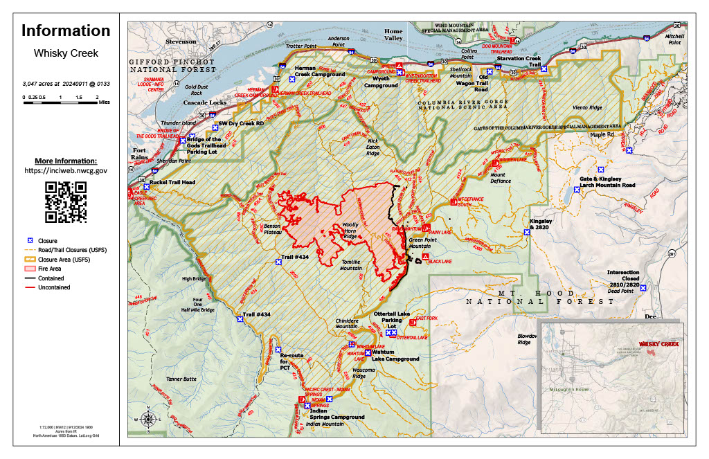
Whisky Creek Size: 3,047 acres | Start Date: July 20 | Cause: Human | Containment: 25%
Total Resources: 112 | Hand Crews: 3 | Engines: 3 | Dozers: 2 | Heavy Equipment: 2 | Helicopters: 1
The Whisky Creek Fire is in steep and rugged terrain within the Mark O. Hatfield Wilderness in the Mt. Hood National Forest. The fire remains within the control lines along the southern and eastern edge. The Eagle Creek Fire scar continues to be a barrier along the western and northern edges of the fire. Cooler weather with high humidity worked together to moderate fire activity again today. Despite the favorable weather, local communities may see smoke at times as dead and downed logs continue burning.
There was not an infrared flight over the fire area to provide updated acreage. Fire management estimates there was little to no growth yesterday with minimal activity. Crews made great progress with suppression repair on the spot fires around Black Lake yesterday. Engine crews worked with Resource Advisors to remove the structure wrap protecting the historic McNeil Cabin above Black Lake. Road grading and repair continues along Forest Road 2820. Firefighters will continue to patrol the accessible portions of the fire perimeter.
Weather: A high-pressure system moved into the area today which will lead to drier and warmer conditions. The next weather system will begin to move into the region tonight and tomorrow. This will bring another round of cooler temperatures and a chance of rain showers.
For smoke forecasts and safety, visit: oregonsmoke.org.
Closures: Area closures remain in the Mt. Hood National Forest, Columbia River Gorge National Scenic Area, and Hood River County. Closures are put into place for the safety of the public and fire crews; intrusion into a closure area can disrupt fire suppression and repair activities, endanger lives and property, and can result in fines. Closure information is at: https://linktr.ee/whisky_creek.2024.
Safety: The public plays an important role in preventing the next wildfire; please use caution with all potential ignition sources. For prevention tips see: https://keeporegongreen.org. The Temporary Flight Restriction remains in effect for the Whisky Fire: https://tinyurl.com/2s49yrj4. Fire restrictions are in place on the Mt. Hood National Forest: https://www.fs.usda.gov/main/mthood/fire.
Actualizacin diaria del incendio Whisky Creek 09 13 2024
Related Incident: Whisky Creek Fire
Publication Type: News
Tamaño de Whisky Creek: 3,047 acres | Fecha de inicio: 20 de julio |Causa: De orígen humano |Contención 25%
Total de recursos: 112 | Equipos de obreros: 3 | Camiones de bomberos: 3 | Topadoras: 2 | Maquinarias pesadas: 2 | Helicópteros: 1
El incendio Whisky Creek se encuentra en un terreno escarpado y escabroso dentro del área de naturaleza Mark O. Hatfield en el Bosque Nacional Mt. Hood. Permanece dentro de las líneas de control a lo largo de los extremos sur y este. La huellas del incendio Eagle Creek continúan como barrera a lo largo de los extremos oeste y norte del incendio. Hoy, el clima más fresco junto con la alta humedad combinaron de nuevo para minimizar la intensidad del incendio. A pesar del clima bueno, puede ser que las comunidades locales vean humo a veces ya que siguen ardiendo los troncos muertos y caídos.
No se realizó un vuelo infrarrojo sobre el área del incendio para actualizar la superficie. La gestión de incendios calcula que el día de ayer hubo poco o ningún crecimiento debido a una intensidad mínima. Las cuadrillas lograron avanzar bastante en la reparación por extinción de los incendios salpicados alrededor de Black Lake ayer. Las cuadrillas de camiones de bomberos trabajaron con los asesores de recursos para remover la envoltura de estructura que protegía la histórica cabaña McNeil por arriba de Black Lake. Se sigue nivelando y reparando las carreteras a lo largo del camino forestal 2820. Los bomberos continuarán patrullando las partes accesibles del perímetro del incendio.
Clima: Se desplazó al área un sistema de alta presión hoy, lo que traerá condiciones más secas y cálidas. Esta noche y mañana el próximo sistema meteorológico comenzará a desplazarse hacia la región. Esto traerá otra ronda de temperaturas más frescas junto con la posibilidad de lluvia.
Para saber el pronóstico de humo y seguridad, consulte: oregonsmoke.org.
Cierres: Los cierres de áreas permanecerán en el Bosque Nacional Mt. Hood, el Área Escénica Nacional Columbia River Gorge y el Condado de Hood River. Se establecen cierres para la seguridad del público y de los bomberos; La intrusión en un área de cierre puede interrumpir las actividades de extinción y reparación de incendios, poner en peligro vidas y propiedades, y puede resultar en multas. La información de cierre se encuentra en: https://linktr.ee/whisky_creek.2024.
Seguridad: El público juega un papel importante en la prevención del próximo incendio forestal; tenga cuidado con cualquier posible fuente de incendio. Para obtener consejos de prevención, consulte: https://keeporegongreen.org. La TFR sigue vigente para el incendio Whisky Creek: https://tinyurl.com/2s49yrj4. Las restricciones contra incendios están vigentes dentro del Bosque Nacional Mt. Hood: https://www.fs.usda.gov/main/mthood/fire.
.jpg?VersionId=5wxLJhaRkM76urgEwbU7crWK34w9GkdK)