
Incident Publication
Wood Lake Fire Closure Order 09092407 Exhibit B 09 12 2024
Related Incident:
Publication Type: Closures
Whisky Creek Fire Update 09 12 2024
Related Incident: Whisky Creek Fire
Publication Type: News
Central Cascades Interagency IMT
Whisky Creek Fire
Sept. 11, 2024
Fire Information: (541) 208-1743, 8 AM - 8 PM
For links to incident information: https://linktr.ee/whisky_creek.2024
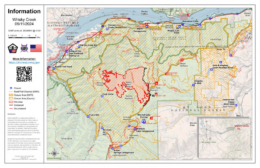
Whisky Creek Size: 3,047 acres | Start Date: July 20 | Cause: Human | Containment: 25%
Total Resources: 165 | Hand Crews: 2 | Engines: 2 | Dozers: 2 | Heavy Equipment: 2 | Helicopters: 1
The Whisky Creek Fire is in steep and rugged terrain within the Mark O. Hatfield Wilderness in the Mt. Hood National Forest. The fire remains within the control lines along the southern and eastern edge. The Eagle Creek Fire scar continues to be a barrier along the western and northern edges of the fire. The fire received precipitation Tuesday night into Wednesday that helped moderate fire behavior yesterday. The rain received was less than forecasted, so Hood River Valley and Columbia River Gorge communities will still see smoke from heavy fuels burning.
The Central Cascades Interagency Incident Management Team took over the Whisky Creek Fire last night. We would like to thank Northwest Team 12 for the amazing work they performed during their assignment. The Sandstone and the Blister Creek Fires will be managed by a local Type 4 organization.
The fire grew minimally yesterday with little to no activity. Crews will continue to do light fire suppression repair to help prevent erosion. Resource advisors continue to work with crews and heavy equipment during the repair efforts to minimize impacts to natural and cultural resources. Firefighters will continue to patrol the accessible portions of the fire perimeter.
Weather: Cooler weather yesterday helped keep fire activity to a minimum. There is potential for another weather system to move into the area over the weekend with forecasted rain.
For smoke forecasts and safety, visit: oregonsmoke.org.
Closures: Area closures will remain in the Mt. Hood National Forest, Columbia River Gorge National Scenic Area, and Hood River County. Closures are put into place for the safety of the public and fire crews; intrusion into a closure area can disrupt fire suppression and repair activities, endanger lives and property, and can result in fines. Closure information is at: https://linktr.ee/whisky_creek.2024.
Safety: The public plays an important role in preventing the next wildfire; please use caution with all potential ignition sources. For prevention tips see: https://keeporegongreen.org. The Temporary Flight Restriction remains in effect for the Whisky Fire: https://tinyurl.com/2s49yrj4. Fire restrictions are in place on the Mt. Hood National Forest: https://www.fs.usda.gov/main/mthood/fire.
Wood Lake Fire Closure Order 09092407 Exhibit A 09 12 2024
Related Incident:
Publication Type: Closures
Lava Fire Daily Update September 12 2024 09 12 2024
Related Incident:
Publication Type: News
Special Notes: As of 6am today, the Boulder Fire is part of the Lava Fire, being managed by the Southern Area Red Complex Incident Management Team. The Lava Fire is currently 93,751 acres with 6 percent containment.
*** There will be a Community Meeting on Friday September 13th at 7:00 PM at the Ola Community Center 2175 Main Street, Ola, ID***
Many thanks to the Wyoming T6 under the leadership of Incident Commanders Josh Erikson and Jamie Ellington for the transition given to the Southern Area Team Red Team. Also, thank you to the Rocky Mountain Team 3 for their coordination and continued support during this transition.
Overview: The Lava Fire is located on the Boise National Forest and the Payette National Forest, north of Emmet and west of Lake Cascade. The Lava Fire was started by lightning on Monday September 2 and is burning in tall grass, brush and timber.
Any private property that remained in an area impacted by the Lava Fire, will need to remain in place until fire managers and Sheriff’s departments deem it safe for reentry.
Operations: Yesterday, the structure protection group took advantage of the more favorable weather conditions to mop up and extinguish areas of heat around structures. Firefighters also worked to establish containment using roads and constructing dozer lines on the eastern flank. The fire has moved into a previous fire scar which has also slowed progression near Hazard Creek and Lookout Peak. The fire was active yesterday west of Lake Cascade near Deer Creek and Hurd Creek prior to the rain moving in. Structure protection was prioritized and continues in this area. On the western flank of the fire, dozer line has been established east of Indian Valley Road, North Crane Road and Spring Creek.
Night shift crews continued to patrol and monitor for fire activity and checking for threats to lines and structures.
Today, fireline construction efforts will continue on all areas of the fire, taking advantage of cooler temperatures and higher humidity. Fire suppression activities will include creating handlines, dozer lines and using natural features to creating and reinforcing containment lines around the fire perimeter.
On the northern flank crews will continue to improve containment lines to slow fire growth to the north. Structure protection personnel will be conducting structure assessments in God’s Acres Subdivision and surrounding communities in Indian Valley.
On the eastern flank Resources continue to improve and hold dozer lines along the Forest Service Road 404 and Willow Creek. Crews will also continue mopping up along the fire perimeter north of Boulder Creek.
On the southern flank Control lines will be established and improved from the west to the east from Chief Eagle Eye Creek to Sage Hen Creek.
Along the western flank resources are scouting opportunities to construct and connect containment line extending north to Little Weiser River Road. Firefighters will continue to monitor fire activity along this west side, keeping fire within current footprint protecting range allotment, grasslands and private property.
Weather/Fire Behavior: Yesterday, precipitation was received across the fire area anywhere from a quarter to a half inch of rain, drastically decreasing overall fire activity. While this did not extinguish the fire, it gave the ground resources opportunities to install and improve lines. Today, humidity will remain high and temperatures will be much cooler, averaging about 20 to 25 degrees below normal. Wind gusts with thunderstorms are possible with winds from the west at 5-10 mph with possible gusts to 15 mph.
Evacuations and road closures:
Adams County Sheriff’s Office issued a LEVEL 3 “GO!” Evacuation notice to residents south of South Grays Creek and along Little Weiser Road in Indian Valley. A LEVEL 2 “SET” Evacuation has been issued for residents North of South Grays Creek Road to Highway 95, and a LEVEL 1 “READY” Evacuation has been issued for the Mesa area.
Gem County Sheriff’s Office issued a LEVEL 3 “GO!” Evacuation notice to residents on Third Fork Road (North of Nesbitt Lane), Second Fork Road (North of Nesbitt Lane), and the Sage Hen Reservoir area. Gem County Sheriff’s Office notified the residents in person on September 8th, 2024. A LEVEL 2 “SET” Evacuation has been issued for Nesbitt Lane residents.
Gem County Road and Bridge issued the following road closures: Third Fork Road at Nesbitt Lane, Second Fork Road at Nesbitt Lane, and Nesbitt Lane. The Sweet-Ola Highway is closed at the High Valley intersection in Ola. Please be advised that the Gem County Sheriff’s Office is staffing the road closure check points.
Valley County Sheriff’s Office has downgraded zones 4, 5, 6 to a “Set” status, effective as of 9/12/2024 at 10:15 am. Zones 7 – 11 remain in their current unchanged in a “Set” status.
Forest Closures and Restrictions: The Boise and Payette National Forests implemented a joint Lava and Boulder Fire Area, Road, and Trail Closure for public and firefighter safety. The closure includes Forest Service lands north of the 601 Road (approximately 7 miles southwest of Smiths Ferry) and north all the way to the northernmost extent of Lake Cascade. This expanded closure order supersedes previous closure orders for the Lava and Boulder fires.
A temporary flight restriction is in effect in and around the fire area. This includes the use of personal drones. If you fly, we cannot fly.
KXGV Radio Interview for Middle Fork Complex Fire Sept 12 2024 09 12 2024
Related Incident:
Publication Type: Announcement
KXGV Radio Host Day Dreamer interviews Garden Valley Fire Chief Paul Cleaveland and PIO Drew Harmon September 12, 2024
Deschutes County Sheriffs Department Updates Evacuation Levels 09 12 2024
Related Incident: Bachelor Complex Fires
Publication Type: Announcement
With improving conditions on the Little Lava Fire and continued suppression efforts, the Deschutes County Sheriff’s Office, in coordination with the Sunriver Police Department and fire managers, are adjusting evacuation levels. The current summary of evacuation changes and maps can be found at: https://deschutes.org/emergency.
Wood Lake Fire Update 09 12 2024
Related Incident:
Publication Type: News
Wood Lake Fire Update
Date: September 12, 2024 Size: 3 acres Containment: 0%
Cause: Under Investigation Start Date: September 10, 2024
Fire Information:
Inciweb page: https://inciweb.wildfire.gov/incident-information/mnsuf-wood-lake-wildfire
Closure Information
Superior NF Facebook: https://www.facebook.com/SuperiorNF
Twitter/X: https://x.com/SuperiorNF
Sign up for Superior NF Fire Information notices and news
Current Status and Resources: Firefighting resources made good progress yesterday and had good overnight relative humidity recovery and light winds that minimized fire spread. The fire is currently backing down off the ridge to Wood Lake. Ground resources are looking at suppression opportunities by strengthening containment lines and scouting for good natural landscape features such as drainages and wetlands to tie into as containment areas. Aircraft are being used to cool the fire and initiate suppression actions with the highest likelihood of success. The National Preparedness Level is current at 5-or the highest level; thus, firefighting suppression resources are limited.
Planned Actions: Resources work to strengthen containment lines with a variety of tools including utilizing pumps and hose lays, using natural features, and using backfiring through hand ignition when needed to reduce spotting potential near the perimeter or containment line. Ground conditions and access is difficult, and vegetation has a heavy spruce budworm infested balsam fir component. Resources are planning and preparing for potentially windier weather conditions later this week that could increase rate and intensity of fire spread.
Closures: The Superior National Forest is implementing Emergency Closure Order #09-09-24-07 for the public’s health and safety due to the Wood Lake fire within the vicinity of recreation areas beginning today, September 12, 2024.
The Closure Order restricts access into BWCAW Entry Point #26-Wood Lake, and a list of area lakes and portages and can be found on the Superior NF website under Closure Orders. For the safety of firefighting resources, no drones are allowed near the fire area and are illegal in federally designated wilderness areas.
Weather and Smoke: Thursday-mostly sunny with a high near 80. South winds 5 to 10 mph, gusting to 15 mph. Evening and night-patchy fog and partly cloudy with a low of 57. South easterly winds at 5 mph with gusts up to 15 mph. Friday-mostly sunny with a high near 80. Breezy south winds 5-15 mph with gusts up to 20 mph. Overall air quality in the Ely area will be MODERATE. Wildfire smoke from Canada is also present in the area. https://www.airnow.gov/and https://www.pca.state.mn.us/air-water-land-climate/air-quality-forecast
Fire Summary: On Tuesday, September 10, 2024, around 11:00 a.m. a fire was detected on an island of Wood Lake, which is located north of County Road 18, within the Boundary Waters Canoe Area Wilderness (BWCAW) of the Superior National Forest (NF). The fire is located in Township 64, Range 10, Section 26 on National Forest System land.
Swauk Creek Fire Update 09 12 2024
Related Incident:
Publication Type: News
Swauk Creek Fire
September 12, 2024
Estimated size: 320 acres
Containment: 3%
Start Date/Time: 9/8/2024 at 3:54 PM
Area of Origin: Adjacent to Highway 97, 14 miles east of Cle Elum, WA
Cause: Vehicle Fire/Under Investigation
Structures Damaged: 0
Update: Crews continued to monitor the Swauk Creek Fire during the night with minimal overnight growth. Crews are watching the fire edges ensuring the fire has not grown or spotted outside of the fire perimeter. Today, crews will continue to identify locations where it is safe to go direct with the fire line. Due to steep terrain, crews will mostly use handlines around the fire edge. Direct line placement may not be a safe option in other locations on the fire where the terrain is steep. In this instance, crews will use indirect lines, placing them away from the fire perimeter. Crews will then monitor the area between the fire perimeter and the indirect fire line to ensure the fire doesn’t grow beyond the newly constructed indirect line. Dozer lines will be used on other areas of the fire to create a wider line to help stop and hold the fire from future growth.
Air resources will continue dropping water and retardant on the fire as long as the weather permits. We will continue to right-size the incident with needed resources, ensuring we are able to perform the needed work safely and efficiently. As more resources arrive, we are able to spread out the workload on the fire line to accomplish more work in a more compressed timeline.
Road Closures: Highway 97 is now open with no restrictions.
Evacuation Levels: The evacuations remain the same as yesterday. They were updated as a precaution; there is no immediate residential threat from this fire. Evacuations can be found on the interactive map. Many Forest Service roads are affected in this area; please review the map if you want to know about a specific location/road.
Live map of active fires from Kittitas County:
https://kitcogis.maps.arcgis.com/.../minima.../index.html...
The First Creek area is currently closed to the public.
Notification Level 3 (Go Now) is shown on the map; however, this area has no residential structures.
Notification Level 2 (Get ready)
- Residences east of US 97 north of fire to Liberty Rd
- Forest Service Road 3506 south of fire to Upper Green Canyon Rd
Notification Level 1 (Be Fire Aware)
- The town of Liberty
- All Liberty Rd
- Forest Service Road 9726 and all of its extensions (including Deer Gulch, Pine Gulch, Robinson Gulch, and Harkness Gulch)
Currently, no evacuation notices are issued for residents south of First Creek or west of US Highway 97.
As always, conditions can change quickly, please stay alert and avoid the area if you feel unsafe.
Weather and Fire Behavior: A weather system will move off to the east, allowing a drier westerly flow to replace it Thursday into Friday. Breezy winds will continue Thursday and then decrease overnight. Today, we anticipate temperatures to be a high of 62-65 degrees and a low of 44-48 degrees tonight.
###