
Incident Publication
McDermott Fire Update 09 12 2024
Related Incident: McDermott
Publication Type: News
Incident Commander: David Mcfee
Location: 16 miles northwest of Philipsburg, MT
Start Date: 8/26/2024
Cause: Undetermined
Size: estimated at 427 acres
Resources on Site: 1 crew; 1 engine; miscellaneous heavy equipment
Total Personnel: 38
The McDermott Fire, located in the Upper Willow Creek area, is burning in an inaccessible area containing a large concentration of standing dead trees (“snags”) that pose challenges to ensuring firefighter safety and in responding to potential medical emergencies.
Fire managers from the Forest, working in collaboration with local county officials and cooperating agency representatives, have identified and prioritized critical values at risk in the fire area. The values most likely to be impacted are located three miles to the east of the fire’s location.
CURRENT STATUS/PLANNED ACTIONS:
Last night the fire received precipitation and cool weather, and additional precipitation is expected. Due to this weather pattern, at the end of today’s shift the incident will transition from a Type 3 Incident Management Team to a Type 4 managed by the local district. Crews will monitor the fire and focus on completing indirect fuel breaks. Fire managers do not expect to see significant fire activity today due to precipitation and cloud cover. The daily update for today, September 12 will be the last one issued unless significant fire activity returns later this fall. Smoke is expected to still be visible at times as the dead and down trees continue to smolder. This is expected for the next several weeks, but the fire is not expected to have much growth.
WEATHER AND FIRE BEHAVIOR:
Last night the fire received 0.25 inches of precipitation. Today there will be areas of patchy fog and cloud clover over the fire. Expect rain showers and possibility of thunderstorms. Temperatures will be in the mid-40’s with humidities from 83-90 percent. Winds could gust to 20 mph this afternoon. Showers and cold temperatures are expected tonight with a slight warm up next week but there is a chance of rain beginning Monday.
CLOSURES AND RESTRICTIONS:
The Forest is in Stage 1 Fire Restrictions. Campfires are allowed only in a permanent metal fire grate/ring provided by the Forest Service in a designated, developed recreation site. Smoking is restricted to vehicles, in buildings, or in an area clear of flammable materials. Devices with an on/off switch that use LPG fuels are allowed in an area clear of flammable materials within 3 feet of the device.
All trails have been opened. Please remember the trails on the Black Pine System are closed to motorized vehicles starting September 1 each year.
Coffee Pot Fire Daily Update 09 12 2024
Related Incident: Coffee Pot Fire
Publication Type: News
Unified Command: CAIIMT15 & CAL FIRE
Fire Size: 13,999 acres
Percent Contained: 41%
Primary Strategic Control Line: 96%
Personnel: 1,062
Cause: Lightning
Start Date: Saturday, August 3, 2024, at 10:05 a.m.
Location: Southeast of Three Rivers, CA
COFFEE POT FIRE PUBLIC MEETING: CIIMT15 will host a public meeting today, September 12, at 6 p.m. at the Three Rivers Memorial Building: 43490 Sierra Drive, Three Rivers. Those unable to attend can watch the meeting live on the Sequoia and Kings Canyon National Parks Facebook page @SequoiaKingsNPS or YouTube channel @sequoiaandkingscanyonnps5018.
CURRENT SITUATION: Airtankers and helicopters applied water on the fire’s northeastern edge and retardant to the control line along the Horse Creek drainage throughout the day yesterday. Fire around the confluence of Horse Creek and the East Fork Kaweah River burned at low to moderate intensity while staying within its current footprint. Hotshot crews conducted burnout operations and worked with air operations to construct and strengthen control lines around Homers Nose.
Today, aerial operations will continue to support crews with tactical retardant drops as they construct direct handline on the north and south sides of Horse Creek and around Homers Nose. In addition, water drops will be used to cool the fire, slowing its spread, allowing firefighters safer opportunities to engage. Firefighters will continue to check for hotspots, strengthen lines, and backhaul equipment along the southern and western flanks of the fire.
WEATHER: As the trough moves eastward, expect a cooler day with steady humidity and lighter afternoon winds, creating a calm and stable atmosphere. The trough’s progression will bring slightly milder conditions, reducing the intensity of both heat and wind while maintaining clear skies. This stable weather pattern should hold throughout the day, offering no significant fluctuations in temperature or moisture levels.
SMOKE IMPACTS: Air quality conditions greatly improved throughout the outlook area due to moderate fire activity. Today expect GOOD air quality conditions North and South of the fire, with MODERATE conditions closest to the fire in Hammond and Three Rivers this morning, but clearing to GOOD air quality throughout the forecast area this afternoon. For more information on current wildfire smoke impacts in your community, please visit AirNow.gov or fire.airnow.gov.
EVACUATION NOTICES: The Tulare County Fire Department has issued Evacuation WARNINGS for zones TLC-E094-B, TLC-E094-C, TLC-E094-D, TLC-E094-E, and TLC-E095. To find your zone, please refer to: protect.genasys.com
FIRE INFORMATION: A Public Information Officer will be at the Three Rivers Village Market daily from 10:30 a.m. to 4 p.m. to provide fire information and answer questions.
BLM AND PARK CLOSURES: The portion of South Fork Drive within Sequoia and Kings Canyon National Parks and trails accessed from the road, including the Ladybug and Garfield Grove Trails, are closed. Recreational access to the Mineral King area of Sequoia National Park is closed to the public. This applies to Mineral King campgrounds, trailheads, and area trails. All other areas of the parks are open but are likely to be impacted by varying levels of smoke and poor air quality. Park closure information is available online at nps.gov/seki. The Bureau of Land Management has also issued a closure of the Case Mountain Extensive Recreation Management Area at blm.gov/press-release.
PUBLIC NOTICE: Wildfires are a no-fly zone for unauthorized aircraft, including drones. If you fly, we can’t. For more information, visit knowbeforeyoufly.org.
Homestead Complex and Lane 1 Fire Update 09 12 2024
Related Incident: Lane 1 Fire
Publication Type: News
Homestead Complex and Lane 1 Fires
Update for Thursday, September 12, 2024
In response to the heavy rains that arrived early yesterday morning, fire managers implemented their safety plan and adjusted operations to ensure firefighter safety and to avoid negative impacts on roads and the natural environment due to heavy rainfall and very saturated soil conditions. Three of the seven fires on the Homestead Complex are 100% contained, the Salmon 33 Fire (275 ac.) on August 24, 2024, the Reynolds Butte Fire (334 ac.) on August 22, 2024, and the Lost Bucket Fire (34 ac.) on July 29, 2024.
Homestead Complex Fire
Start Date: July 19, 2024
Size: 9,483 acres
Overall Containment: 31%
Personnel: 476
Location: 30 miles NE of Glide, OR
Cause: Lightning
Fire Information: https://tinyurl.com/25vkhfjp
Lane 1 Fire
Start Date: July 17, 2024
Size: 25,951 acres
Containment: 99%
Personnel: 92
Location: Approx. 16 miles SE of Springfield, OR
Cause: Lightning
Fire Information: https://tinyurl.com/29k3nnly
Fire Operations Summary:
Yesterday on the Horse Heaven Fire (2,715 acres, containment: 56%), fire managers directed firefighters to not engage in suppression operations on the northern flank of the fire due to extremely heavy rains, saturated soils, and concerns with falling trees and rolling material. Work on other flanks of the fire continued with chipping and log hauling where road conditions were stable. Today, fire manages will be assessing whether crews can reengage suppression and mop-up efforts on the north flank and continue with chipping, log hauling, and suppression repair on the other flanks of the fire. Fire managers will also be assessing whether conditions are safe and stable enough to continue with completing containment line down into Horse Heaven Creek and opening up an alternate resource access point to the northwest.
On the Fuller Lake Fire (3,516 ac., containment: 0%), the heavy rains and saturated soils limited operations. On the east flank, road conditions were so poor that operations were suspended for most of the day. The risk of having heavy trucks and equipment cause damage to the roads, and having vehicles getting stuck in the mud, was very likely. On the north and west flank, only a small amount of work on road clean-up was completed. Today fire managers plan to reengage operations on all flanks of the fire to secure existing, and construct additional, control lines. Work to re-open the 3850 is also planned.
The Bullpup Fire (520 ac., containment: 7%) remains within primary and secondary control lines. Very little road clean-up work was completed due to heavy rains and poor road conditions. Today, fire managers plan to reengage all planned operations. The priority objective for fire managers is to prevent the fire from progressing further north toward critical habitat for wild steelhead (the Frank and Jeanne Moore Wild Steelhead Special Management Area).
On the No Man Fire (2,089 ac., containment: 44%), on the north flank of the fire, crews were able to continue with road work doing chipping and hauling. However, road conditions on the south flank were too wet to allow for planned road grading and roller work. Today, crews plan to reengage with patrolling, mopping-up, chipping, hauling logs and conducting suppression repair operations. No work was done yesterday on the Reynolds Butte and Lost Bucket fires.
On the Lane 1 Fire (29,951 ac., containment: 99%), reported rain fall amounts were some of the highest of any of the fires in the area. Only a limited amount of chipping was done before heavy rains put a halt to operations. Planned road grading was postponed due to saturated road conditions. Today, fire managers plan to reengage all planned operations.
Closures and Fire Restrictions:
There are two closure orders impacting every district of the Umpqua National Forest https://www.fs.usda.gov/alerts/umpqua/alerts-notices. The forest is in High Fire Danger with Public Use Restrictions (PURs) at Level 2: https://www.fs.usda.gov/detail/umpqua/fire/?cid=FSEPRD937986
The closure order issued by Bureau of Land Management (BLM), Roseburg District, for portions of BLM land which border the Umpqua National Forest Emergency Fire Closure north of Steamboat remains in effect: https://www.blm.gov/sites/default/files/docs/2024-07/orwa-fpo-rbg-072624.pdf
Weather: Tomorrow will be slightly warmer and drier. Winds will be light and variable in the morning and becoming north to northwesterly in the afternoon. Temperatures will range from the 50s at higher elevations to lower 60s in the valleys.
There is a Temporary Flight Restriction (TFR) over the fires. Please remember, if you fly we can’t! If a drone or other aircraft enters the air space, all firefighting aviation equipment will be grounded.
Fire Information Line: 541-208-7100 (Staffed 8 a.m. to 8 p.m.)
Email: 2024.homesteadcomplex@firenet.gov
Facebook: https://www.facebook.com/HomesteadComplexFireInfo/
Fossil Complex Morning Update 09 12 2024
Related Incident: Fossil Complex
Publication Type: News
Cooler Weather Will Help in Firefighting Efforts
SPRAY, Ore. – Yesterday’s showers and the cooler weather has resulted in reduced fire behavior. For the Service Fire, this provided a good opportunity to build direct fire line with hand crews and dozers. Along the north side of the fire, the crews are continuing to build fire lines immediately adjacent to the fire and start plumbing with fire hose. On the east side, which was recently most active, crews are securing the perimeter by establishing and reinforcing existing containment lines. On the southeast corner, the crews are getting into the fire and starting to lay hose lays to begin mop up to secure the fire perimeter.
Chipping operations and mop up along ORE 19 will continue to prepare for opening the highway. Oregon Department of Transportation is planning on opening the highway tomorrow. Check for updates on ODOTs TripCheck - https://tripcheck.com/
Last night, the community meeting in Fossil was attended by over 40 people. ODF Incident Commander Matt Howard and other fire and local representatives presented to the attendees and answered questions.
Videos: Due to an issue with the Fossil Complex Facebook page, recordings of the meeting and Daily Operations Updates will be available at: https://www.youtube.com/@FossilComplex
Community Meeting:
Tonight, there is a community meeting in Spray at The Rock, 601 Willow St. at 6:30 PM.
The Wheeler County Sheriff’s Office continually evaluates evacuation levels. Please check their Facebook page for the latest information. https://www.facebook.com/WheelerCountySheriffsOffice/
The Two Cabin, Holmes, Kinzua and Canyon Fires are all in patrol status.
Flying unauthorized drones is hazardous to aircraft and will ground critical aerial operations.
FIRE AT A GLANCE
Fossil Complex
Total Size: 22,441 acres
Two Cabin-253 acres
Canyon-190 acres
Kinzua-96 acres
Holmes-15 acres
Service- 21,887
Containment: 3%
Cause: Lightning
Current Cost: $9.8 M
All Resources
Hand Crews: 40
Engines: 58
Water Tender: 16
Dozers: 20
Skidders: 7
Skidgen: 3
Excavator: 2
Masticator: 2
Feller Buncher: 4
Total Resources: 1,255
Aerial Resources
Type 1: 3
Type 2: 6
Type 3: 4
Evacuations:
Level 1: 21 addresses
Level 2: 85 addresses
Level 3: 156 addresses
https://www.facebook.com/WheelerCountySheriffsOffice/
ODF Incident Commander:
Matt Howard
Incident Management Team 2
Sept 13 Middle Fork Complex Fire Community Meeting Announcement 09 12 2024
Related Incident:
Publication Type: Announcement
Middle Fork Complex Fire Community Meeting
September 13, 2025 at 6 pm
Join the Great Basin Complex Incident Management Team 5 for updates on the Middle Fork Complex Fire.
The meeting will be recorded and posted on Facebook (Middle Fork Complex Fire, Boise National Forest) and YouTube (https://www.youtube.com/@2024.middleforkcomplex).
White Barn
Near 85 Severance Rd
Garden Valley, Idaho
Buck Creek and Bowman Well Fire Update 09 12 2024
Related Incident: Buck Creek Fire
Publication Type: News
Buck Creek Size: 5,062 acres | Reported Date: September 7 | Cause: Lightning | Containment: 0%
Bowman Well Size: 2,852 acres | Reported Date: September 6 | Cause: Lightning | Containment: 75%
Total Resources Personnel: 500 | Crews: 13 | Engines: 26 | Water Tenders: | Heavy Equipment: 8 | Helicopters: 7
(Silver Lake, Ore.) – The Buck Creek Fire started in heavy timber on the Fremont-Winema National Forest about 12 miles southwest of Silver Lake, Ore. in a semi-primitive area of the Forest with limited road access. The Bowman Well Fire is burning in sage brush, grass and juniper on lands administered by the Bureau of Land Management about 3 miles northwest of Christmas Valley, Ore. Public and firefighter safety remain the top priority on these incidents. Even with gusty winds from the west, the higher humidity from fleeting thunderstorms resulted in little fire movement, affording firefighters and equipment the opportunity to make excellent progress. No structures have been lost or damaged.
Buck Creek: On the north edge of the fire, private timber company resources and day and night shift firefighters used heavy equipment to install dozer line east from Rodman Rock to Bridge Creek. On the west flank, smokejumpers completed hand line and installing hose along the fire edge from Bridge Creek north to the southern slope of Rodman Rock. On the south and east edges, firefighters scouted for opportunities to connect new direct fire line with completed line on the north and west flanks. Crews also mopped up hot spots near the completed line, which reduces the risk of fire crossing the line.
Today, crews will continue to install dozer and hand line as the terrain allows. They will also set up hose to aid mop up activities, and scout places to build direct fire line in areas with the highest probability of success. With light and variable winds from the west, fire behavior may be most active where winds align with terrain. Felling crews are reducing the hazard posed by fire weakened trees. Aviation resources remain available to assist as visibility allows.
Bowman Well: Windy conditions and no measurable precipitation yesterday resulted in isolated burning within the Bowman Well Fire. Although there has been an increase in acreage, there continues to be no growth beyond the fire’s established perimeter. Today, firefighters will continue to reinforce control lines.
Evacuations: In coordination with fire managers, the Lake County Sheriff has established evacuations for both the Buck Creek and Bowman Well fires. Go to www.lakecountyor.org for details about evacuation levels.
Weather: Slightly warmer daytime temperatures are forecast for today, with light and variable winds from the west. No precipitation is expected.
Safety: School buses, cattle, and firefighting equipment and crews are present on local roads. Fire managers ask the public to drive attentively and to remain clear of the fire areas. The public also plays an important role in preventing the next wildfire by using caution with all ignition sources. For prevention tips visit, https://keeporegongreen.org. Current fire danger is extreme and restrictions are in place within the Fremont-Winema National Forest. More information can be found at:
https://www.fs.usda.gov/detail/fremont-winema/news-events/?cid=FSEPRD1188568
Closures: Christmas Valley Airport is temporarily closed to general aviation because it is being used as the helibase for fire operations. The temporary flight restriction (TFR) over the Bowman Well Fire was lifted yesterday. The TFR over the Buck Creek Fire remains in place.
Smoke: Smoke from multiple fires around the region is affecting the area. For more information on smoke conditions and strategies on limiting exposure, go to: www.oregonsmoke.org or www.AirNow.gov.
Airport Fire Incident Update 09 12 2024
Related Incident:
Publication Type: News
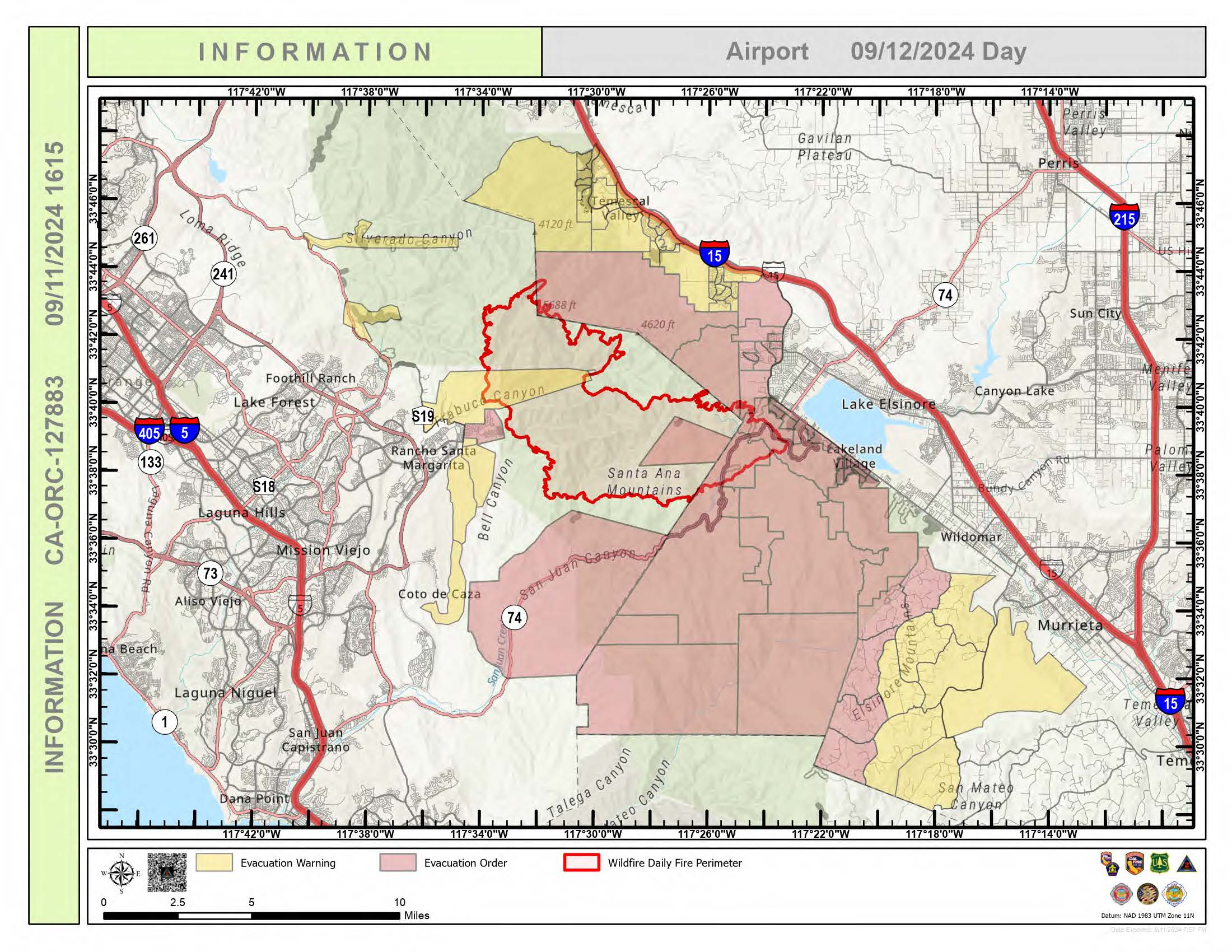
Location: Trabuco Canyon, CA
Personnel: 771
Start Date: 9/9/ 2024 01:00pm
Cause: Human
Size: 23,410 acres
Percent contained: 5%
The Airport Fire remains a significant threat to Orange County and Riverside County communities. While the Orange County Incident Management team has transitioned to California Incident Management Team 2, a unified command structure remains in place to coordinate efforts across all cooperating agencies. Through relentless firefighting, crews have managed to contain 5% of the Airport Fire, marking a positive step towards controlling the fire.
To effectively combat the fire, firefighter priorities include containing the northern flank, constructing fire lines, seizing favorable weather conditions for direct engagement, and maintaining strong coordination between agencies. Ongoing tasks involve monitoring fire behavior and supporting affected communities. By prioritizing these actions, firefighters can minimize damage and protect the affected communities. The fire continues to spread along all fronts, with the southeastern fronts showing the most growth. The fire made several runs at the Santiago Peak communications array this morning. Although there was some damage, the facility continues to function. The fire has crossed Ortega Highway and the fire has impacted structures in the area; firefighters are actively engaged in these areas. Crews will continue constructing direct and indirect fire lines while scouting for additional opportunities to establish containment lines.
Weather permitting and when terrain and fire behavior allow, firefighters will build line directly along the fires edge. The work of current and incoming hand crews is essential for capitalizing on this favorable window. Firefighters continue working both day and night shifts, along with helicopters, air tankers, and heavy equipment, to continue engaging the fire on all sides to limit the lateral spread. Additional resources are in neighborhoods and communities, providing defense of structures and critical infrastructure. Damage assessments will be conducted within the fire area as conditions allow, prioritizing safety. Due to the nature of the fire, multiple areas have experienced structural damage, and the full extent of the losses is currently being evaluated. A damage assessment team will be deployed to survey the affected areas and provide a more accurate count of damaged structures. Additional firefighting resource requests are being made to our partner agencies around the state.
Evacuations remain in place to protect lives, but the unpredictable nature of the fire poses risks to those who remain in the affected areas. To minimize the damage and ensure the safety of all, individuals and communities should follow evacuation orders, stay informed about the situation, prepare for potential power outages, protect their property if possible, and support relief efforts.
The safety of firefighters and the public remains paramount in our response to the Airport Fire. Unfortunately, there have been reported injuries among both firefighters and the public. The fire managers will continue to actively implement measures to mitigate these risks and ensure the safety of all personnel involved.
Evacuation Center Locations & Services:
Orange County:
Civilian:
RSM Bell Tower Community Center
22232 El Paseo; Rancho Santa Margarita, CA (Open 24 Hours)
Large Animals:
Orange County Fairgrounds Los Alamitos Race Course Nohl Ranch Saddle Club
88 Fair Drive; Costa Mesa, CA 4961 Katella Avenue, Cypress, CA 6352 E. Nohl Ranch Rd. Anaheim, CA
(714) 708-1588 (714) 820-2830 (714) 308-1093
Animal Services:
OC Animal Care
1630 Victory Road; Tustin, CA
Riverside County:
Civilian:
Temescal Canyon High School Santiago High School
28755 El Toro Road, Lake Elsinore, CA 1395 E Foothill Pkwy, Corona, CA
Temescal Canyon High School
28755 El Toro Rd, Lake Elsinore, CA.
In the big gym equipped with cots, air conditioning, Wi-Fi, water, snacks, and welcoming staff.
Animal Shelters:
Jurupa Valley Animal Shelter:
6851 Van Buren Blvd, Jurupa Valley, CA
Large Animal Shelter:
Murrieta Equestrian Center
42670 Juniper St, Murrieta, CA.
Basic food and water are available at animal shelters. If your pets/animals have special diets or special needs, please bring special food or medications with your animals.
Large Animal Evacuations:
Riverside residents that need animal assistance can call (951) 358-7387.
Evacuation Orders:
Orange County:
Evacuation Warning Evacuation Order
Rose Canyon Robinson Ranch
Trabuco Canyon Ortega Highway
Dove Canyon Caspers Park
Silverado Canyon Blue Jay Campground
Modjeska Canyon El Cariso
East Side Coto de Caza
For updated evacuation zones, please visit ocsheriff.gov/airportfire
Riverside County:
Evacuation Warning
RVC-1153-A, RVC-1265, RVC-1267, RVC-1269, RVC-1395, RVC-1396, RVC-1397, RVC-1398, RVC-1399, RVC-1400, RVC-1401, RVC-1402, RVC-1404, RVC-1405, RVC-1522, RVC-1523, RVC-2076, RVC-2077, RVC-2145, RVC-2146, RVC-2147, RVC-2244, RVC-2245, RVC-1160, RVC-1154, RVC-1156, RVC-1052, RVC-1155, RVC-1263, RVC-1158, RVC-1262, RVC-1161, RVC-1157, RVC-1261, RVC-1259, RVC-1260, RVC-1266, RVC-1159, RVC-1050
Evacuation Order
LSN-1524, LSN-1525, LSN-1526, LSN-1623, LSN-1624, LSN-1625, LSN-1626, LSN-1627, LSN-1799, LSN-1803, RVC-1521, RVC-1622, RVC-1724, RVC-1725, RVC-1726, RVC-1728, RVC-1729, RVC-1798, RVC-1800, RVC-1801, RVC-1802, RVC-1804, RVC-1806, RVC-1807, RVC-1808, RVC-1809, RVC-1810, RVC-1865, RVC-1866, RVC-1867, RVC-1868, RVC-1869, RVC-1870, RVC-1933, RVC-1934, RVC-1935, RVC-1936, RVC-1999, RVC-2000, RVC-2074, RVC-2075, RVC-2142, RVC-2143, RVC-2144, RVC-2197, RVC-2243
For updated evacuation zones, please visit https://rivcoready.org/alert-rivco
Road Closures:
Plano Trabuco / Joshua Drive Santa Margarita Parkway / Antonio Parkway
Plano Trabuco / Robinson Ranch Avenida Empressa / Santa Margarita Parkway
Antonio Parkway / Alas de Paz Trabuco Canyon / Trabuco Creek
Santiago Canyon Road Live Oak Canyon Road
Ortega Highway (east of Quarry to Grand Avenue in Lake Elsinore)
Resources:
Engines:134
Water Tenders: 17
Helicopters: 10
Air Tankers: 10
Hand Crews: 8
Dozers: 7
Other: 0
Total Personnel: 771
Cooperating Agencies:
CHP, Orange County Parks, California State Parks, Orange County Animal Control, CalOES, OC Public Works.

Bachelor Complex Flat Top and Firestone Fires Update 09 12 2024
Related Incident: Bachelor Complex FiresFlat Top and Firestone Fires
Publication Type: News
Northwest 3 Complex Incident Management Team
Lonnie Click, Incident Commander
September 12, 2024
Bachelor Complex, Flat Top, and Firestone Fires Update
Quick Facts: Bachelor Complex
Size: 10,332 acres Start Date: Sept 8, 2024 Location: Mt Bachelor, 20 miles SW Bend, OR
Personnel: 248
Quick Facts: Firestone & Flat Top Fires
Firestone Size: 8,787 acres Start Date: Sept 6, 2024 Location: North of Fort Rock, OR
Flat Top Size: 30,643 acres Personnel: 116
Yesterday firefighters continued to work on suppressing the Bachelor Complex, Flat Top and Firestone Fires which saw slow to moderate growth on Wednesday due to cooler, wetter weather. This decrease in fire activity allowed crews to focus efforts on putting in containment lines on the fires. A helibase was established in Sunriver to support aerial resources. Firefighting operations include connecting roads with dozer lines and handlines both directly adjacent to the fire and further away, where indirect strategies are more effective. No new fires were reported on Wednesday. Today, firefighters will work on structure protection in the vicinity of Sheridan Mountain and west of Sunriver. Firefighters will continue to establish and secure containment lines around the Bachelor Complex, Flat Top, and Firestone Fires. Aerial resources will continue to help with suppression efforts.
Bachelor Complex: The Bachelor Complex is a group of about 30 fires that range from one tenth of an acre to over 9,500 acres, for a total of 10,332 acres. The cooler wet weather slowed fire spread on the Little Lava Fire and crews capitalized on the opportunity, making good progress toward securing the fire’s edge east of Forest Service Road 45 with dozer line. Moderated fire behavior is expected again today, and firefighters will continue those efforts. They are using Forest Service Road 4525 to connect roads and trails to serve as containment lines. The Backside, 911, and 892 Fires are higher up on the Cascade Crest and received almost one tenth of an inch of precipitation yesterday. Today, firefighters will continue to secure and mop up the Backside Fire and smokejumpers continue to mop up the 911 Fire.
Flat Top Fire: Yesterday, firefighters were able to directly engage putting fire on the ground to help secure control lines on the north and northeast sides of the fire. The crews working overnight reported no increase in size for this fire. Today, firefighters will continue work on securing the north side and conduct lighting operations off of Forest Service Road 22 to strengthen containment lines by consume vegetation between the line and the active edge of the fire.
Firestone Fire: Yesterday, firefighters were able to get most of the western edge of the fire secure. They used hand and dozer lines to stitch together a containment line with the existing road system. Work will continue securing the north side of the fire.
Safety: With increased fire traffic, everyone in the area is reminded to drive slowly and carefully in evacuation areas. If you don’t need to be in the area, please stay clear to allow firefighters plenty of time and space to work.
Weather and Fire Behavior: Bachelor Complex fires received more rain than Flat Top or Firestone Fires yesterday. The amount of precipitation on the Little Lava Fire was not enough to have long-lasting effects. Vegetation beneath the tree canopy remains dry and ninety percent of this fire has an active perimeter. The Backside, 892, and 911 Fires received more moisture which significantly slowed fire spread. Based on the weather outlook for the higher elevation fires on the Bachelor Complex, fire behavior analysts predict another mild day for fire behavior. On the Flat Top and Firestone Fires, stumps and logs are expected to continue burning while grasses and shrubs aren’t expected to dry out enough to be receptive to ignition until this afternoon. Scattered showers are expected throughout day over all fires.
Evacuations: Emergency management and fire officials are closely coordinating and adjusting evacuation levels as needed. Level 3 evacuations mean “Go Now,” Level 2 means “Be Set,” and Level 1 means "Be Ready.”
To view current evacuation levels, please visit the Deschutes County Emergency Information Interactive Map at: http://www.deschutes.org/emergency. For Lake County evacuation information, please visit: https://www.lakecountyor.org/flat_top.php
Closures: There are two closure areas on the Deschutes National Forest for these fires. View the orders on the Deschutes National Forest site at: https://www.fs.usda.gov/alerts/deschutes/alerts-notices.
Facebook
https://www.facebook.com/deschutesnationalforest/
InciWeb
https://inciweb.wildfire.gov/incident-information/ordef-bachelor-complex-fires
https://inciweb.wildfire.gov/incident-information/ordef-flat-top-and-firestone-fires
Fire Information Line: 541-249-9829, 8:00 a.m. to 8:00 p.m.
Rail Ridge Fire Update September 12 2024 09 12 2024
Related Incident:
Publication Type: News
Contact us
Phone: 541-208-7111
Email: 2024.railridge@firenet.gov Facebook: Rail Ridge Fire - Oregon 2024
Inciweb: https://inciweb.wildfire.gov/incident-information/orocf-rail-ridge
LinkTree: https://linktr.ee/RailRidgeFire
Closures and Evacuations
Closures: The Forest Service and BLM have implemented partial closures due to the Rail Ridge Fire and Crazy Creek Fire, for all uses. For more details and closure maps, visit the Ochoco National Forest, Malheur National Forest, and BLM web pages.
Evacuations: Shelters are available to evacuees. For up-to-date evacuation information, please visit:
- Crook County: Crook County Emergency Management website and Crook County Sheriff’s Office Facebook page.
- Wheeler County: Visit the Wheeler County Sheriff’s Office Facebook page for real-time updates.
- Grant County: Grant County Emergency Management Facebook page.
Operational Update:
There is a community meeting tonight at the Paulina Community Center, at 5 p.m.
Address: 70299 Paulina City Rd, Paulina, OR 97751
Resources continue to prioritize efforts to protect local communities, structures and land. Today, the focus is on boxing in the northwest edge of the fire by completing control line to ensure the fire doesn’t flank out and impact nearby communities. In the Battle Creek area, heavy equipment will continue to address access issues, while considering long-term impacts on road conditions.
In the Guyon Basin, resources continue to tie control lines together across the South Fork area, working to keep the area behind Dayville secure. Oregon State Fire Marshal (OSFM) task forces will extend mop up around structures in this area, working down to the South Fork Road. Along Fields Creek/FSR 21, road prep work continues, and firefighters will be looking for opportunities to engage directly with the fire. Multiple air resources will be available to assist with suppression efforts throughout the day, weather permitting.
In the Morgan Mountain area, the focus remains on completing containment lines around the slop fire. Within the fire perimeter, there is an unburned island near Sugarloaf Mountain that crews will be assessing for potential firing operations. On the south and southwest portions of the fire, nominal fire behavior has been observed and crews will continue to complete mop up and hold control lines, working towards Wolf Mountain and tying line into road systems out to the west. OSFM resources have wrapped up structural triage and prep on the south end and will be assisting wildland partners with mop up along control lines.
Wildland crews will be engaged in mop up throughout the fire area, focusing on heat still holding in the junipers. These trees hold considerable heat in their root systems and make them susceptible to torching. By addressing these types of hazards, the fire line becomes more secure and long-term stability on the incident is improved.
Overnight, resources focused on maintaining the progress achieved during day shift. The fire area received wetting rains until about midnight, resulting in minimal fire behavior that did not challenge any containment lines. Crews monitored, patrolled and held established control lines and worked to keep key access roads open against snags and hazard debris. This has been especially challenging for crews working along FSR 2150, which provides vital access to critical communications infrastructure at Aldrich Lookout. Battle Creek Road had to be shut down due to heavy rainfall during the night.
Yesterday, favorable weather contributed to reduced fire activity, and minimal growth was noted. The Dayville, Morgan Mountain, and Battle Creek areas were prioritized. Near Dayville, OSFM crews mopped 100’ out from structures that were near the fire line. Crews took advantage of cooler temperatures to secure the area behind the community of Dayville, tying together control lines and mopping up, while OSFM crews ensured areas around structures were cool and secure.
At the slop over near Morgan Mountain, containment lines were extended, and very little fire behavior was observed. As wildland resources installed line and engaged with the fire there, OSFM task forces provided structure protection to homes in the area and assisted with monitoring established line. The area is now about 85% lined.
Near Battle Creek, heavy equipment was used to improve access points for crews to reach fire within the wilderness area that has been slowly crawling in the lighter fuels. Resources in this area have been hampered by access and have been using both direct and indirect tactics.
On the southern edge of the fire, crews remained in patrol mode and conducted mop up operations. Due to multiple days of minimal fire growth during the night, several hand crews are being reallocated to day shift to support incident objectives.
With the reduction in fire activity and the significant preparation work that has been completed, OSFM is able to downsize the number of task forces assigned to the Rail Ridge Fire. Cooperative efforts of resources have contributed to significant progress and fire activity has been minimized in the vicinity of structures. Task forces from Washington state and Yamhill County will return to their home agencies today, leaving six OSFM task forces (30 apparatus), assigned to the fire. These remaining crews will continue to provide around the clock structural protection, with a heavy presence in Dayville, South Fork Road, Fields Creek, and Morgan Mountain areas.
Weather:
Showers continued into the night, providing wetting rains over the fire. Cool conditions will continue today, with seasonably cool and dry conditions expected across the fire through the coming weekend.
Middle Fork Complex Operations Video September 12 2024 09 12 2024
Related Incident:
Publication Type: Announcement
Middle Fork Complex Operations Video September 12, 2024
https://www.youtube.com/watch?v=YodZy_jRJPg