
Incident Publication
Devils Knob Fire Administrative Road Closure USFS no Order Number 09 27 2024
Related Incident:
Publication Type: Closures
Date(s): Sep 27, 2024 - Jan 15, 2025
Forest Order: Devils Knob Fire Administrative Road Closure
See a map of this closure.
Starting today, September 27, 2024, Emergency Fire Forest Closure order number 06-15-02-24-03 for the Devils Knob Fire has been rescinded. However, an administrative closure has gone into effect today, September 27, 2024, for some roads in the Devils Knob footprint where firefighters are still working.
Roads pictured below will remain under an emergency closure for public safety concerns and firefighting operations. The road systems will remain open to through traffic by residents, landowners, private industrial timber operators, and those with permits or permission from the Umpqua National Forest. Operators accessing their properties should communicate with the Tiller Ranger District to ensure safe coordination on road systems.
At times, the identified roads may be temporarily closed even for landowners and those with permissions to pass through. These instances will identified with a physical road barricade and flaggers. Through traffic in these areas will be permitted once it is deemed safe by firefighting personnel. However, please expect up to 60 minutes stops.
Incident Commander John Truett speaks to the community as the Southwest Complex Incident Management Team 2 transitions off of the Park Fire 09 11 2024
Related Incident: Park Fire
Publication Type: Announcement
Click the link for a message from Incident Commander John Truett
Buck Creek and Bowman Well Fire Update 09 11 2024
Related Incident: Buck Creek Fire
Publication Type: News
Buck Creek Size: 5,062 acres | Reported Date: September 7 | Cause: Lightning | Containment: 0%
Bowman Well Size: 2,727 acres | Reported Date: September 6 | Cause: Lightning | Containment: 15%
Total Resources Personnel: 419 | Crews: 11 | Engines: 23 | Water Tenders: 5 | Heavy Equipment: 14 | Helicopters: 3
(Silver Lake, Ore.) – The Buck Creek Fire started in heavy timber on the Fremont-Winema National Forest about 12 miles southwest of Silver Lake, Ore. in a semi-primitive area of the Forest with limited road access. The Bowman Well Fire is burning in sage brush, grass and juniper on lands administered by the Bureau of Land Management about 3 miles northwest of Christmas Valley, Ore. Public and firefighter safety remain the top priority on the incidents. This morning, in remembrance of September 11, 2001 attacks, Incident Commander Steve North led personnel in a moment of silence to honor the 2,996 victims.
Buck Creek: Greater than expected northwesterly winds led to very active fire behavior on the Buck Creek Fire Monday afternoon, causing growth to the east and a smoke column visible across Lake County. However, aviation resources helped keep the fire’s spread out of private timber land to the north. Yesterday, smoke jumpers continued their efforts on the fire’s southern edge, using saws and other hand tools to build 10’ – 20’ direct containment lines from Buck Creek to Bridge Creek’s western fork. Firefighters have been working in partnership with private timber company resources to build, hold and improve containment lines along the fire’s northern perimeter. As the morning’s temperature inversion lifted, fire activity increased. Fire managers used both helicopter and fixed-wing aviation resources to cool the advancing flames and apply retardant. Erratic winds and poor visibility due to smoke conditions challenged efforts to precisely target water bucket and air tanker drops. Today, firefighters will continue to secure the fire’s southern perimeter and look for opportunities to connect those containment lines with others under construction along the fire’s western flank. Efforts along the northern edge are ongoing as heavy equipment operators and hand crews build containment lines.
Bowman Well: There was no growth on the Bowman Well Fire and containment remained steady at 15%. As of Wednesday morning, the Lake County Sheriff’s Office has reduced all evacuation notices to Level 1 “Be Ready” for potential evacuation. For more information, see the attached map or visit the Lake County website at www.lakecountyor.org. Although firefighters continue to reinforce control lines around the fire’s perimeter, resources are being reassigned to the Buck Creek Fire.
Weather: Rainfall is forecast to begin this morning with a chance of thunderstorms by afternoon. Cool weather will persist through Thursday, with seasonal temperatures returning by week’s end.
Safety: For everyone’s safety, fire managers ask the public to drive attentively and to remain clear of the fire areas. The public also plays an important role in preventing the next wildfire by using caution with all ignition sources. For prevention tips visit, https://keeporegongreen.org. Current fire danger is extreme and restrictions are in place within the Fremont-Winema National Forest. More information can be found at:
https://www.fs.usda.gov/detail/fremont-winema/news-events/?cid=FSEPRD1188568
Closures: Starting today, Christmas Valley Airport will be temporarily closed to general aviation use as the site begins service as a helibase for fire operations. A temporary flight restriction is in place over both fires.
Smoke: Smoke from multiple fires around the region is affecting the area. For more information on smoke conditions and strategies on limiting exposure, go to: www.oregonsmoke.org or www.AirNow.gov.
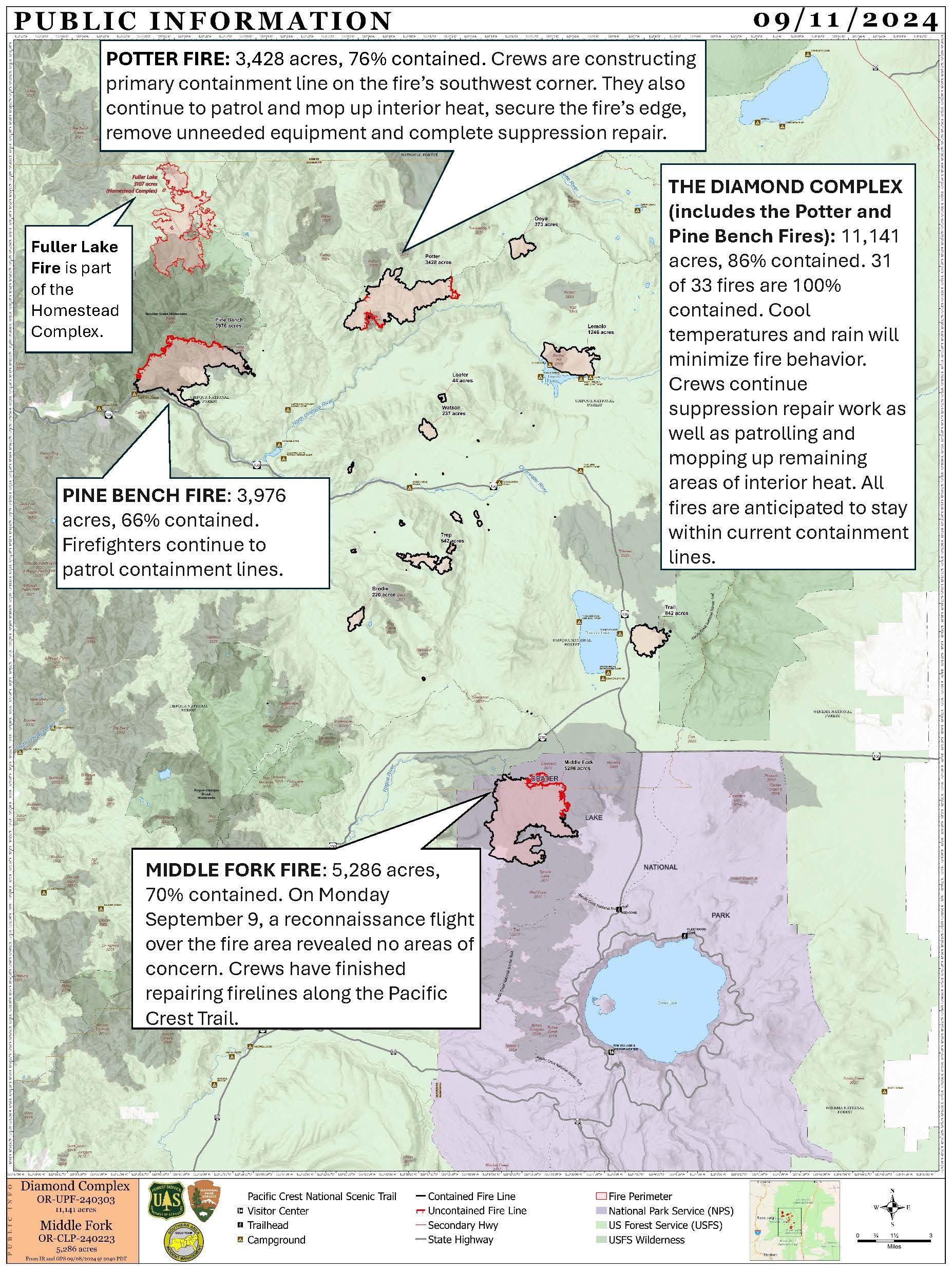
Diamond Complex and Middle Fork Fire Update for September 1112 2024 09 11 2024
Related Incident: Middle Fork Fire
Publication Type: News
Diamond Complex
- Size: 11,141 acres
- Containment: 86%
- Personnel: 599
- Location: 18 miles SW of Chemult, OR
- Start Date: July 19, 2024
- Cause: Undetermined
Middle Fork Fire
- Size: 5,286 acres
- Containment: 70%
- Personnel: 29
- Location: Crater Lake National Park
- Start Date: July 17, 2024
- Cause: Undetermined
Incident Management Team Transition
The Southern Area Gold Complex Incident Management Team will transition management of the Diamond Complex and Middle Fork Fire to California Team 14 on Friday, September 13, 2024, at 6 a.m. Incident Commander Debbie Beard thanks the local communities, cooperators and staff of Crater Lake National Park and the Umpqua and Rogue River-Siskiyou National Forests for supporting our firefighters.
Visitor and Firefighter Safety, and Fire Restrictions
For everyone’s safety, please slow down and drive carefully near firefighter activity. Roads will be slick today and debris flows are possible.
CLOSED AREAS: Area, road and trail closures remain in place. Do not enter closed areas or drive around barriers. Entire roadways may not be blocked to allow firefighter traffic. Areas are closed due to dangerous conditions like falling trees, heavy equipment and road grading.
Current Fire Situation
The Diamond Complex includes 33 fires in the Umpqua National Forest, 31 of which are 100% contained. Cool temperatures and rain will minimize fire behavior. Crews continue suppression repair work as well as patrolling and mopping up remaining areas of interior heat. All fires are anticipated to stay within current containment lines.
Middle Fork Fire
On Monday, a reconnaissance flight over the fire area revealed no areas of concern. Crews have finished repairing firelines along the Pacific Crest Trail.
Diamond Complex
- Pine Bench Fire (north of Hwy. 138 near Dry Creek, 3,976 acres, 66% contained): Firefighters continue to patrol containment lines.
- Potter Fire (north of Hwy. 138, 2 miles southeast of Potter Mountain, 3,428 acres, 76% contained): Crews are constructing primary containment line on the fire’s southwest corner. They also continue to patrol and mop up interior heat, secure the fire’s edge, remove unneeded equipment and complete suppression repair.
Weather and Fire Behavior
Fire behavior will be minimal as rain continues today and into Thursday. Between 0.5 to 1 inch of rain is expected over the fire area. High temperatures in the 50s and lows in the 30s. Friday and Saturday will be cool and dry with high temperatures in the 60s. The chance for additional rain increases moving into Sunday.
Smoke Outlook
Smoke from the Diamond Complex and Middle Fork Fires is minimal. However, winds may push smoke from nearby fires into the area. For more information, visit www.fire.airnow.gov.
Forest Closure and Fire Restrictions
The Umpqua National Forest has two closure orders in place that impact every ranger district on the forest. Specific roads, trails and campgrounds are listed as exemptions. The forest remains in high fire danger and Public Use Restrictions and Industrial Fire Precaution Levels remain at Level 2.
For information on Forest Order 06-15-24-07 for the Diamond Complex, visit https://www.fs.usda.gov/alerts/umpqua/alerts-notices/?aid=88996.
For information on Forest Order 06-15-24-03 for the Devils Knob Fire on the Tiller Ranger District, visit https://www.fs.usda.gov/alerts/umpqua/alerts-notices/?aid=90511.
A closure is in place on Rogue River-Siskiyou National Forest for the area north and west of Crater Lake National Park along Hwy. 230 south to the intersection with Hwy. 62. The current closure order, map and fire restrictions are available at https://www.fs.usda.gov/alerts/rogue-siskiyou/alerts-notices.
Park Closure and Fire Restrictions
Crater Lake National Park is open. However, several trail closures are in effect. For details, visit https://www.nps.gov/crla/planyourvisit/conditions.htm.
Know before you go. Check the latest conditions and road status to ensure a smooth, enjoyable visit. Updates are available on Oregon Tripcheck at https://www.tripcheck.com.
Red Fire Daily Update for Wednesday September 11 2024 09 11 2024
Related Incident: Red Fire
Publication Type: News
![]()
![]()
![]()
Willamette Complex South & Red Fire Update
Red, 208, Moss Mountain, Coffee Pot, Tire Mountain, McKinley Creek and Chalk Fires
Date: Wednesday, September 11, 2024 Fire Causes: Lightning
Email: 2024.willamettecomplex@firenet.gov Information Phone Line: 541-208-1742
Willamette Complex South: Total Personnel: 674 | Total Willamette Complex South Acres: 23,197
InciWeb: https://inciweb.wildfire.gov/incident-information/orwif-willamette-complex-fires-south
Facebook: https://www.facebook.com/WillametteComplexFires/
Red Fire: Total Personnel: 67 | Total Red Fire Acres: 1,732
InciWeb: https://inciweb.wildfire.gov/incident-information/ordef-red-fire
Facebook: https://www.facebook.com/2024RedFireOR/
Summary
With rain and cooler weather accompanied by possible thunderstorms predicted for today into tomorrow, NW Team 2 remains available to support extended attack on new starts to the northeast of Oakridge and initial attack on any emergent fires in the area. Firefighters also remain focused on building containment. Today’s rain will allow mop-up operations to begin to build depth in areas where fire activity is reduced. Lastly, work continues on repairing road surfaces and removing material from the roadside. Patrols continue on contained fires (Coffee Pot, Tire Mountain, and McKinley Creek). Observable fire behavior on Tuesday was mostly low intensity ground fire with gradual spread. An even slower rate of fire spread, and smoldering is anticipated for today.
Red Fire (1,732 acres, 0% containment)
Protecting structures and managing fire growth in this area remains the focus. Resources have been working from the White Fish Trailhead and continue to support suppression efforts to keep the fire within the indirect lines. Structure preparation is ongoing as the fire continues to near Forest Service Road (FSR) 60. Pumps and hoses are in place and being checked regularly to protect these important values at risk. Yesterday, low smoke and the adjacent ridgelines sheltered the area from the potential for increased fire behavior from the passing winds. Fire behavior was moderate yesterday despite continued low relative humidity.
208 Fire (8,843 acres, 0% containment)
The 208 Fire is gradually growing towards FSR 23 on the northwest and FSR 21/2154 on the south. Fire behavior is primarily backing, surface fire. Firefighters continue to strengthen these roads with mastication and snag felling. Additionally, coordination with private timber is ongoing to build contingency line FSR 23 to FSR 423. This line will tie in with the existing lines for the Moss Mountain fire in the event of future fire growth to the north from the 208 Fire or south from Moss Mountain Fire.
Moss Mountain Fire (2,133 acres, 8% containment)
Crews have finished chipping operations on FSR 23, and mastication operations will be ongoing. Primary and contingency lines are being implemented and secured along FSR 23, 2120, 490, and 2309 to confine northward spread of the fire to minimize burned acres. Dozer lines are being prepared along FSR 23, 2307, and 2308.
Chalk Fire (5,987 acres, 86% containment)
Monitoring and improvements to containment lines is ongoing to minimize fire impacts to the communities of High Prairie, Westfir, Lowell, Oakridge, and other surrounding private inholdings. Firefighters continue to work the line hauling slash and chipping, primarily on the northwest corner and western flank of the fire.
Weather and Fire Behavior
Smoke cover along with rising humidity levels on Tuesday moderated fire behavior ahead of today’s wetting rains. Significant rainfall is expected throughout the day on today with potential for heavier rainfall along ridges accompanied by scattered thunderstorms. Rains are predicted to continue into Thursday morning.
Closures, Fire Restrictions, and Evacuations
- For closure information, visit: https://tinyurl.com/RedFireClosues2024 & https://tinyurl.com/WillFireClosures2024.
- For fire restrictions, visit: https://tinyurl.com/DesFireRestrictions2024 & https://tinyurl.com/WillFireRestrictions2024.
- For current Temporary Flight Restrictions (TFR), visit: http://tfr.faa.gov.
- The Level 1 – BE READY to Evacuate notice remains in effect for the Red Fire. For more information or to sign up for alerts, visit: www.klamathcounty.org/300/emergency-management.
Willamette Complex South Daily Update for Wednesday September 11 2024 09 11 2024
Related Incident: Willamette Complex Fires - South
Publication Type: News
![]()
![]()
![]()
Willamette Complex South & Red Fire Update
Red, 208, Moss Mountain, Coffee Pot, Tire Mountain, McKinley Creek and Chalk Fires
Date: Wednesday, September 11, 2024 Fire Causes: Lightning
Email: 2024.willamettecomplex@firenet.gov Information Phone Line: 541-208-1742
Willamette Complex South: Total Personnel: 674 | Total Willamette Complex South Acres: 23,197
InciWeb: https://inciweb.wildfire.gov/incident-information/orwif-willamette-complex-fires-south
Facebook: https://www.facebook.com/WillametteComplexFires/
Red Fire: Total Personnel: 67 | Total Red Fire Acres: 1,732
InciWeb: https://inciweb.wildfire.gov/incident-information/ordef-red-fire
Facebook: https://www.facebook.com/2024RedFireOR/
Summary
With rain and cooler weather accompanied by possible thunderstorms predicted for today into tomorrow, NW Team 2 remains available to support extended attack on new starts to the northeast of Oakridge and initial attack on any emergent fires in the area. Firefighters also remain focused on building containment. Today’s rain will allow mop-up operations to begin to build depth in areas where fire activity is reduced. Lastly, work continues on repairing road surfaces and removing material from the roadside. Patrols continue on contained fires (Coffee Pot, Tire Mountain, and McKinley Creek). Observable fire behavior on Tuesday was mostly low intensity ground fire with gradual spread. An even slower rate of fire spread, and smoldering is anticipated for today.
Red Fire (1,732 acres, 0% containment)
Protecting structures and managing fire growth in this area remains the focus. Resources have been working from the White Fish Trailhead and continue to support suppression efforts to keep the fire within the indirect lines. Structure preparation is ongoing as the fire continues to near Forest Service Road (FSR) 60. Pumps and hoses are in place and being checked regularly to protect these important values at risk. Yesterday, low smoke and the adjacent ridgelines sheltered the area from the potential for increased fire behavior from the passing winds. Fire behavior was moderate yesterday despite continued low relative humidity.
208 Fire (8,843 acres, 0% containment)
The 208 Fire is gradually growing towards FSR 23 on the northwest and FSR 21/2154 on the south. Fire behavior is primarily backing, surface fire. Firefighters continue to strengthen these roads with mastication and snag felling. Additionally, coordination with private timber is ongoing to build contingency line FSR 23 to FSR 423. This line will tie in with the existing lines for the Moss Mountain fire in the event of future fire growth to the north from the 208 Fire or south from Moss Mountain Fire.
Moss Mountain Fire (2,133 acres, 8% containment)
Crews have finished chipping operations on FSR 23, and mastication operations will be ongoing. Primary and contingency lines are being implemented and secured along FSR 23, 2120, 490, and 2309 to confine northward spread of the fire to minimize burned acres. Dozer lines are being prepared along FSR 23, 2307, and 2308.
Chalk Fire (5,987 acres, 86% containment)
Monitoring and improvements to containment lines is ongoing to minimize fire impacts to the communities of High Prairie, Westfir, Lowell, Oakridge, and other surrounding private inholdings. Firefighters continue to work the line hauling slash and chipping, primarily on the northwest corner and western flank of the fire.
Weather and Fire Behavior
Smoke cover along with rising humidity levels on Tuesday moderated fire behavior ahead of today’s wetting rains. Significant rainfall is expected throughout the day on today with potential for heavier rainfall along ridges accompanied by scattered thunderstorms. Rains are predicted to continue into Thursday morning.
Closures, Fire Restrictions, and Evacuations
- For closure information, visit: https://tinyurl.com/RedFireClosues2024 & https://tinyurl.com/WillFireClosures2024.
- For fire restrictions, visit: https://tinyurl.com/DesFireRestrictions2024 & https://tinyurl.com/WillFireRestrictions2024.
- For current Temporary Flight Restrictions (TFR), visit: http://tfr.faa.gov.
- The Level 1 – BE READY to Evacuate notice remains in effect for the Red Fire. For more information or to sign up for alerts, visit: www.klamathcounty.org/300/emergency-management.
.jpg?VersionId=JLVDgyvftI7Tr6NH0UsjDm8yF0ebcbj5)
Park Fire Update 09 11 2024
Related Incident: Park Fire
Publication Type: News
Park Fire Update: Wednesday, September 11, 2024
Southwest Complex Incident Management Team 2
Incident Commander John Truett
Size: 429,603 acres
Start Date: July 24, 2024
Containment: 99 percent
Total Personnel: 391
Repairs Completed: 185 of 417 repair points, 5 of 7 miles of handline, 73 of 99 miles of dozer line, 66 of 101 miles of roads as line, 27 of 49 miles of other repair lines
Resources: 1 helicopter, 2 crews, 3 engines, 2 dozers, 5 water tenders, 1 chipper, 4 excavators, 2 feller bunchers, 4 skidders, 1 log loader, 1 backhoe, 2 road graders
IN TRIBUTE: Today marks the anniversary of the attacks on our nation in 2001 that resulted in a loss of 2,958 lives. It is also a time to reflect on the countless people from around the world who responded to the attacks with acts of selflessness and compassion. Southwest Complex Incident Management Team 2 was one of the incident management teams called to New York City in the aftermath of the attacks. Some team members who responded in 2001 are still on the team today.
CURRENT SITUATION: This is the final Park Fire update from Southwest Complex Incident Management Team 2 (SWCIMT2). The Park Fire information line will be staffed until 8 p.m. today; thereafter, Lassen National Forest Public Affairs Officer Amber Marshall will be the point of contact for information regarding the fire (530-250-7400, amber.marshall@usda.gov).
The Forest Service’s National Incident Management Organization (NIMO) Team 3 arrived yesterday, received an in-brief, and began collecting information in preparation to take over the fire this evening. The incident will be managed with fewer personnel and resources, but fire-suppression repair work will continue. The hazard-tree group has several days’ work ahead of them along Ponderosa Way. The suppression-repair group has work to keep them busy for at least a week in the area south of Turner Mountain. The roads group has several days’ work around Turner Mountain Loop and the Bear Wallow area.
WEATHER & SAFETY: Winds today will be gusty and, as the day progresses, will blow from almost every direction. Top gusts could reach 40 mph. Temperatures continue their downward trend, and humidity will rise slightly, but wind trumps temperature and humidity when it comes to fire behavior. The constantly changing winds will generate short-duration smokes from within the fire perimeter. These will not pose a risk to fire containment. Additionally, these winds will bring snags and hazard trees to the ground, so abide by the forest closure order. Finally, these conditions would encourage the spread of any new fires, so be particularly cautious while recreating and using equipment outdoors and be aware of applicable fire restrictions.
FOREST CLOSURE: Some Lassen National Forest lands, roads, and trails remain temporarily closed for the safety of the public and firefighters during the repair phase of the fire. Prior to recreating on your public lands, view Forest Order No. 06-24-07 and the map here: fs.usda.gov/alerts/lassen/alerts-notices. Knowing the forest-closure status in the areas where you are working or recreating is your responsibility.
FIRE RESTRICTIONS: Fire restrictions remain in effect on Lassen National Forest. For details, view Forest Order No. 06-24-04 here: fs.usda.gov/alerts/lassen/alerts-notices. Knowing fire restrictions in the areas where you are living, working or recreating is your responsibility.
Lassen National Forest Public Affairs Office:
530-250-7400 | amber.marshall@usda.gov
![]()
Park Fire Information (through September 11):
530-414-9298 | 2024.park@firenet.gov | linktr.ee/park_fire
Middle Fork Complex Operations Video September 11 2024 09 11 2024
Related Incident:
Publication Type: Announcement
Today's Middle Fork Complex operations video for September 11, 2024
Actualizacin Sobre Incendio Park Mircoles 11 de Septiembre de 2024 09 11 2024
Related Incident: Park Fire
Publication Type: News
Actualización Sobre Incendio Park: Miércoles, 11 de Septiembre de 2024
Administración De Incidentes Complejos Del Área Suroeste - Equipo 2
John Truett - Comandante Del Incidente
Tamaño: 429,603 acres
Fecha de Inicio: 24 de Julio de 2024
Contencion: 99%
Personal Total: 391
Reparaciones completadas: 185 de 417 puntos de reparación, 5 de 7 millas de línea de mano, 73 de 99 millas de línea de topadora, 66 de 101 millas caminos de línea, 27 de 49 millas de otra línea de reparación.
Recursos: 1 helicóptero, 2 cuadrillas, 3 camiones de bomberos, 2 topadoras, 5 camiones de agua, 1 astilladora, 4 excavadoras, 2 máquinas para talar árboles, 4 minicargadoras, 1 apiladora, 1 retroexcavadora, 2 motoniveladoras
EN HOMENAJE: Hoy se cumple el aniversario de los ataques a nuestra nación en 2001 que resultaron en la pérdida de 2.958 vidas. También es un momento para reflexionar sobre las innumerables personas de todo el mundo que respondieron a los ataques con actos de altruismo y compasión. El Equipo 2 Administración De Incidentes Complejos Del Área Suroeste fue uno de los equipos administrativos de incidentes llamados a la ciudad de Nueva York después de los ataques. Algunos miembros del equipo que respondieron en 2001 todavía están en el equipo hoy.
SITUACIÓN ACTUAL: Esta es la última actualización sobre el incendio Park del Equipo 2 Administración De Incidentes Complejos Del Área Suroeste (SWCIMT2). La línea de información del incendio Park contará con personal hasta las 8 p.m. hoy; A partir de entonces, la Oficial de Asuntos Públicos del Bosque Nacional Lassen, Amber Marshall, será el punto de contacto para obtener información sobre el incendio (530-250-7400, amber.marshall@usda.gov).
Ayer, llegó el equipo 3 de la Organización Nacional de Manejo de Incidentes (NIMO) del Servicio Forestal, recibió un informe y comenzó a recopilar información en preparación para hacerse cargo del incendio hoy. El incidente se administrará con menos personal y recursos, pero continuarán los trabajos de reparación de extinción de incendios. El equipo de árboles peligrosos tiene varios días de trabajo por delante a lo largo de Ponderosa Way. El equipo de reparación de supresión tiene trabajo para mantenerlos ocupados durante al menos una semana en el área al sur de Turner Mountain. El equipo de carreteras tiene varios días de trabajo alrededor de Turner Mountain Loop y el área de Bear Wallow.
CLIMA Y SEGURIDAD CONTRA INCENDIOS: Los vientos de hoy serán racheados y, a medida que avance el día, soplarán desde casi todas direcciones. Las ráfagas máximas podrían alcanzar las 40 mph. Las temperaturas continúan su tendencia a la baja y la humedad aumentará ligeramente, pero el viento supera a la temperatura y la humedad en lo que respecta al comportamiento del fuego. Los vientos en constante cambio generarán humo de corta duración desde dentro del perímetro del incendio. Estos no representarán un riesgo para la contención del fuego. Además, estos vientos traerán árboles enganchados y peligrosos al suelo, por lo que se debe respetar la orden de cierre del bosque. Finalmente, estas condiciones fomentarían la propagación de nuevos incendios, así que tenga especial cuidado al recrear y utilizar equipos al aire libre y tenga en cuenta las restricciones contra incendios aplicables.
CIERRE DE BOSQUES: Algunos terrenos, caminos y senderos del Bosque Nacional Lassen cerca del área del incendio están cerrados temporalmente por la seguridad del público y de los bomberos durante la fase de reparación del incendio. Antes de recrear en sus tierras públicas, consulte la Orden Forestal No. 06-24-07 y el mapa aquí: fs.usda.gov/alerts/lassen/alerts-notices. Es su responsabilidad saber dónde se encuentra en relación con la orden de cierre.
RESTRICCIONES DE INCENDIO: Las restricciones contra incendios siguen vigentes en toda el área. Para más detalles, consulte la Orden Forestal No. 06-24-04 aquí: fs.usda.gov/alerts/lassen/alerts-notices. Conocer las restricciones contra incendios en las áreas donde vive, trabaja o se recrea es su responsabilidad.
Oficina de Asuntos Públicos del Bosque Nacional Lassen:
![]() 530-250-7400, ámbar.marshall@usda.gov
530-250-7400, ámbar.marshall@usda.gov
Información sobre incendio Park (hasta el 11 de septiembre):
530-414-9298 | 2024.park@firenet.gov | linktr.ee/park_fire
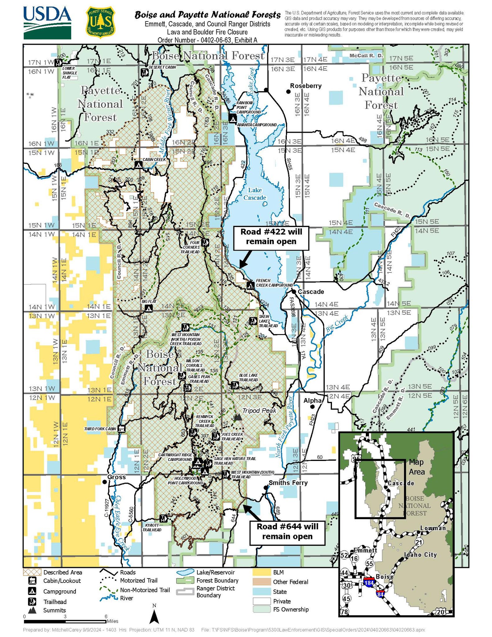
West Mountain Fires Closures Evacuation Information Fire Restrictions TFR Important Links September 11 2024 09 11 2024
Related Incident: Boulder FireDollar Fire
Publication Type: Announcement
FOREST CLOSURES
Boise National Forest:
- Closure Order #0402-04-100 Dollar/Oro Area, Trail, and Road Closure – For Forest closure areas over the Dollar fire. For more information visit: https://www.fs.usda.gov/Internet/FSE_DOCUMENTS/fseprd1199005.pdf
- Closure Order #0402-06-60 Anderson-Bulldog-Nellie Fire Area, Road, and Trail Closure – For Forest closure areas over the Goat and Snag Fires. For more information visit: https://www.fs.usda.gov/Internet/FSE_DOCUMENTS/fseprd1201349.pdf
- Closure Order #0402-06-63 Lava Fire Area, Road, and Trail Closure – For Forest closure areas around the Lava and Boulder Fires. For more information visit: https://www.fs.usda.gov/Internet/FSE_DOCUMENTS/fseprd1203488.pdf
Payette National Forest:
- Closure Order #0412-606 Wolf Creek Burned Area Road and Trail Closure - encompassing National Forest System Trail #560 and NFS Road #1762. For more information visit: https://www.fs.usda.gov/Internet/FSE_DOCUMENTS/fseprd1202093.pdf
- Closure Order #0412-605 Dollar Fire Area and Trail Closure - north of Warm Lake Road, west of South Fork Salmon River, east of NFS Trail #101, and south of NFS Trail #99 and #100. For more information visit: https://www.fs.usda.gov/Internet/FSE_DOCUMENTS/fseprd1201446.pdf
FIRE RESTRICTIONS
The Boise National Forest is in Stage 1 Fire Restrictions. For more information visit: Boise National Forest.
EVACUATION INFORMATION
Valley County Sheriff’s Office is responsible for issuing and enforcing evacuation orders, and for determining the boundaries of the evacuation area. Fire managers advise the sheriff when management action trigger points have been breached.
There are currently READY, SET and GO evacuation orders in place. To stay up to date with the most current information, sign up for emergency alerts, such as evacuation notices by visiting your county’s emergency alert system:
- Valley County:(208) 382-5160 https://www.co.valley.id.us/CompleteEmergencyNotificationandAlerting
Contact Valley County Dispatch at (208) 382-5160 for information on evacuation shelters
Review the READY, SET, GO evacuation procedure for Valley County: https://www.co.valley.id.us/ReadySetGo
ROAD CLOSURES
Warm Lake Highway Closure: Piloted access continues. Warm Lake Rd will be opened for homeowners and contractors only. You will need to be on the approved list for travel. If you have already been approved, you do not need to sign up again. To be added to the approved list please visit:
- Valley County: https://www.co.valley.id.us/EscortRequest Or Call: (208) 382-5160
- Active fire behavior continues in the area, please drive slowly, be aware of crews working in the area and watch out for debris.
- National Forest System (NFS) Road 474 is now OPEN from the Boise National Forest boundary to Warm Lake.
TEMPORARY FLIGHT RESTRICTIONS
Temporary Flight Restrictions (TFR) are in place over the Boulder, Dollar, Snag, and Goat Fires. Wildfires are a no- fly zone for unauthorized aircraft, including drones. TFRs are critical for firefighter and aircraft safety. If you fly, we can’t. For more information, visit http://knowbeforeyoufly.org.
Latest version: Sept. 11, 2024