
Incident Publication
Middle Fork Complex crews assisting with two new starts in the Garden Valley area 09 11 2024
Related Incident:
Publication Type: Announcement
Middle Fork Complex crews are assisting local resources with two new starts in the Garden Valley area. One of the two starts is the Cross Fire, and is located near Coski Creek, south of Garden Valley. A helicopter assessed the second start from the air and personnel are working to access it from the ground and confirm the location. It is west of Crouch.
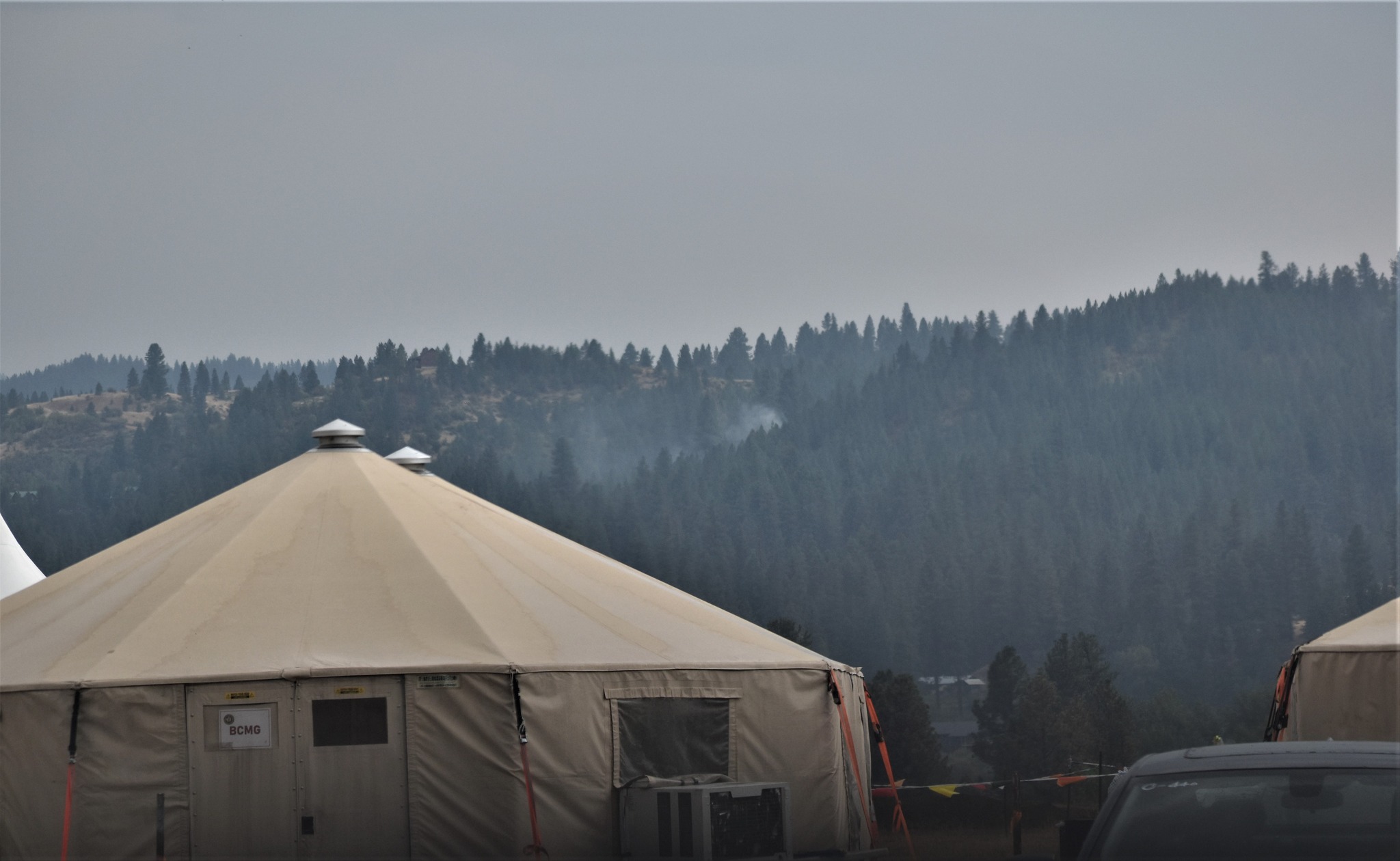
Middle Fork Complex crews are assisting local resources with two new starts in the Garden Valley area.
View of a new start from the Middle Fork Complex in Garden Valley, Idaho, September 11, 2024.
Wood Lake Fire Facts SheetSeptember 11 2024 09 11 2024
Related Incident:
Publication Type: News
Wood Lake Fire Fact Sheet
Date: September 11, 2024 11:00 AM
Fire Information and Location: On Tuesday, September 10, 2024, around 11:00 a.m. a fire was detected on an island of Wood Lake, which is located north of County Road 18, within the Boundary Waters Canoe Area Wilderness (BWCAW) of the Superior National Forest (NF). The fire is located in Township 64, Range 10, Section 26 on National Forest System Lands.
Description: The fire is approximately 3-5 acres and is burning in timber with a heavy, dead balsam fir component. It is suspected to be human caused; however, an official fire investigation has not occurred yet. Initial aircraft fire size up showed the fire creeping, smoldering, and burning in deep duff. The fire spotted off the island to a ridgetop and began to torch and exhibit active fire behavior. The fire area and surrounding landscape has thick vegetation and a significant amount of spruce budworm infested balsam fir.
Current Status and Resources: As of this morning, the fire was creeping, smoldering, and holding in place due to good overnight relative humidity levels and light to no winds. Above average temperatures and drought conditions continue across the Superior National Forest and fire area. Increased winds are expected for the Thursday- Friday.
The Superior National Forest is utilizing aircraft to cool the fire and initiate suppression actions with the highest likelihood of success. Firefighters are working on full suppression tactics; however, ground conditions and access are difficult. Additional aircraft have been ordered to assist with the fire as they become available. Wildfire smoke from Canada is also present in the area. The National Preparedness Level is current at 5-or the highest level; thus, firefighting suppression resources are limited.
Closures and further information: Due to safety concerns, BWCAW Entry Point #26 permittees have been contacted. This is an ever-changing event, and we ask the traveling public to stay away from the area and seek alternate routes. To stay up to date, please sign up for Superior NF Fire Information notices and news. For the safety of firefighting resources, no drones are allowed near the fire area.
McDermott Fire Update 09 11 2024
Related Incident: McDermott
Publication Type: News
Incident Commander: David Mcfee
Location: 16 miles northwest of Philipsburg, MT
Start Date: 8/26/2024
Cause: Undetermined
Size: estimated at 425 acres
Resources on Site: 1 crew; 2 engines; 1 helicopter; miscellaneous heavy equipment
Total Personnel: 38
The McDermott Fire, located in the Upper Willow Creek area, is burning in an inaccessible area containing a large concentration of standing dead trees (“snags”) that pose challenges to ensuring firefighter safety and in responding to potential medical emergencies.
Fire managers from the Forest, working in collaboration with local county officials and cooperating agency representatives, have identified and prioritized critical values at risk in the fire area. The closest values are located three miles to the east of the fire’s location.
CURRENT STATUS/PLANNED ACTIONS:
This incident is being managed by a Type 3 Incident Management Team.
Yesterday the crew and sawyers continued to suppress hot spots that advanced ahead of the fire to the east and northeast with direct and indirect tactics. Aviation support was limited due to concentrations of heavy smoke in the area from larger fires near the McDermott fire. Fire resources are concentrating both ground and aviation resources to minimize potential fire spread that may threaten private property. Machinery with masticators are clearing roads of heavy vegetation to improve access for fire resources and potentially serve as a fire control line if fire spreads.
WEATHER AND FIRE BEHAVIOR:
Today showers and thunderstorms will be increasing from 3 pm onward. Chances of wetting rain are high into Thursday. There is a 90% probability of at least 0.50” of rain in the 48 hours between Wednesday afternoon and Friday afternoon with a probability of at least 1” of rainfall. Gusty outflow winds are a concern with any thunderstorms on Wednesday afternoon along with brief heavy rainfall. Temperatures will be in the low to mid-60’s with relative humidities between 36-41 percent. There will occasional wind gusts to 15 mph.
The fire made forward progression to the north and northwest into an unnamed drainage near McDermott Gulch. With increased cloud cover and anticipated wetting rain today, there should be a decrease in fire activity compared to yesterday.
CLOSURES AND RESTRICTIONS:
The Forest is in Stage 1 Fire Restrictions. Campfires are allowed only in a permanent metal fire grate/ring provided by the Forest Service in a designated, developed recreation site. Smoking is restricted to vehicles, in buildings, or in an area clear of flammable materials. Devices with an on/off switch that use LPG fuels are allowed in an area clear of flammable materials within 3 feet of the device.
Forest fire managers have closed trails in the area near the fire for public safety.
These trails include the following:
Black Pine Ridge Trail #8006
McDermott Gulch Trail # 8238
Pole Ridge Trail # 8237
Horsetheif Trail # 8297
Schilo Creek Trail # 8240
Upper Will Trail #8106
Rattling Gulch Trail
The public is encouraged to refrain from entering these areas for their safety and to allow for safe and effective firefighting operations. Heavy equipment, helicopters, and firefighters will be operating near the eastern flank of the fire and adjacent areas.
Community Meeting Wednesday September 11 2024 09 11 2024
Related Incident: Bachelor Complex Fires
Publication Type: Announcement
A community meeting is scheduled today in the cafeteria at Three Rivers Elementary School located at 56900 Enterprise Drive, Sunriver Oregon. Please email questions in advance to 2024.bachelorcomplex@firenet.gov
Bachelor Complex Flat Top and Firestone Update 09 11 2024
Related Incident: Bachelor Complex FiresFlat Top and Firestone Fires
Publication Type: News
Northwest 3 Complex Incident Management Team
Lonnie Click ~ Incident Commander
September 11, 2024
Bachelor Complex, Flat Top, and Firestone Fires Update
Firefighters continued to work on suppressing the Bachelor Complex, Flat Top and Firestone Fires which actively burned on Tuesday. The Deschutes County Sheriff's Office expanded the areas in Evacuation Levels for public safety and adjusted the interactive map on their website to reflect the changes. (Link below). A public meeting will be held at the Three Rivers Elementary School cafeteria in Sunriver at 6:00 p.m. today. Firefighting resources continued to arrive, and engage, and aircraft continued to drop water and fire retardant on fire areas. Additional air resources are also incoming with a helibase to be established at Sunriver Airport on Wednesday. Smoky skies are expected to improve by evening.
Bachelor Complex: The Bachelor Complex is a group of about 30 fires that range from one tenth of an acre to over 9,500 acres, for a total of 10,330 acres. The Little Lava Fire, about two miles southeast of Little Lava Lake, was very active again on Tuesday, pushed by wind moving across Forest Service Road 45 nearly three miles to the east with a total fire size of approximately 9,848 acres by day’s end. Firefighters constructed dozer line to slow fire spread. Firefighters worked both a swing shift and a night shift last night and made great progress constructing line around the fire that crossed the 45 Road. Fire suppression efforts are ongoing for other fires in the complex.
Flat Top Fire: Winds again drove fire growth on the Flat Top Fire Tuesday, pushing it to the east across Forest Service Road 22 and Forest Service Road 18. Embers spotted into older lodgepole pine a quarter of a mile ahead of the fire’s head, increasing fire growth into dry vegetation. Night shift did good work to construct line and burn out strategic sections along the western perimeter. The fire is currently estimated at 30,643 acres. Aircraft dropped fire retardant to slow fire growth and protect the Cabin Lake Guard Station, which remains secure.
Firestone Fire: The Firestone Fire also intensively burned on Tuesday under a wind influence. Firefighters are using the road system to build containment lines that will limit the spread of both the Flat Top and Firestone Fires to the east and west as they grow toward each other. The Firestone Fire is approximately 8,787acres with a reduction due to better mapping.
Safety: With increased fire traffic and expected rain on roads that haven’t had rain in a while, everyone in the area is reminded to drive slowly and carefully in evacuation areas. If you don’t need to be in the area, please stay clear to allow firefighters plenty of time and space to drive.
Weather and Fire Behavior: Downdraft winds ahead of the incoming rainstorm began overnight, increasing fire behavior in some spots across all of the fires. Today, overcast skies, elevated humidity and forecasted rain is anticipated to have a positive effect on fire suppression. Firefighters expect continued fire activity and spread across dry vegetation, especially where there are heavier dead and downed trees. Small, wind-driven tree torching is likely, but long-range ember spotting and sustained tree crown fire is unlikely if forecasted rain is significant enough.
Evacuations: Emergency management and fire officials are coordinating closely and adjusting evacuation levels as needed. Level 3 evacuations mean “Go Now,” Level 2 means “Be Set,” and Level 1 means "Be Ready.” To view current evacuation levels, please visit the Deschutes County Emergency Information Interactive Map at: http://www.deschutes.org/emergency. For Lake County evacuation information, please visit: https://www.lakecountyor.org/flat_top.php
CLOSURES: There are two closure areas on the Deschutes National Forest for these fires. View the orders on the Deschutes National Forest site at: https://www.fs.usda.gov/alerts/deschutes/alerts-notices.
Facebook
https://www.facebook.com/deschutesnationalforest/
InciWeb Pages By Fire:
https://inciweb.wildfire.gov/incident-information/ordef-bachelor-complex-fires
https://inciweb.wildfire.gov/incident-information/ordef-flat-top-and-firestone-fires
Fire Information Line: 541-249-9829, 8:00 a.m. to 8:00 p.m.
Helpful Links 09 11 2024
Related Incident: Davis Fire
Publication Type: Announcement
For #DavisFire information Follow U.S. Forest Service-Humboldt-Toiyabe National Forest
https://www.facebook.com/HumboldtToiyabeNF
To see fire cameras and view a time lapse visit:
https://alertnevada.live/cam-console/12184
For evacuation info :
https://perimetermap.com/incidents/point/40539
For road closures:
For power outages:
https://www.nvenergy.com/outages-and-emergencies/view-current-outages
To see aircraft being used :
https://www.flightradar24.com/39.30,-119.81/12
For local county questions such as donations and volunteer questions:
Call Washoe County EOC 775-328-2003
Helpful Links 09 11 2024
Related Incident:
Publication Type: Announcement
For #DavisFire information Follow U.S. Forest Service-Humboldt-Toiyabe National Forest
https://www.facebook.com/HumboldtToiyabeNF
To see fire cameras and view a time lapse visit:
https://alertnevada.live/cam-console/12184
For evacuation info :
https://perimetermap.com/incidents/point/40539
For road closures:
For power outages:
https://www.nvenergy.com/outages-and-emergencies/view-current-outages
To see aircraft being used :
https://www.flightradar24.com/39.30,-119.81/12
For local county questions such as donations and volunteer questions:
Call Washoe County EOC 775-328-2003
Fossil Complex AM Update 9112024 09 11 2024
Related Incident: Fossil Complex
Publication Type: News
Overnight growth dampened by precipitation over the Fossil Complex
SPRAY, Ore. – Westerly winds continued yesterday and into the evening and pushed the Service Fire to grow to the east, increasing its size to 21,887 acres. Overnight, the Service Fire was actively growing until 4am, making it difficult to establish lines in front of the growth. Night shift crews focused on structure protection along Winlock Road due to the fire being active late into the morning.
There was new fire start north of the Service Fire, which was caught and lined at 15 acres. Crews maintained and strengthened lines to the east of ORE 19 and along the north and south of the Service Fire.
Light rain is expected over the fire area later today while amounts will vary across the fire area. Lower temperatures and higher relative humidity will minimize fire growth helping crews working on building fire lines.
Today’s priorities are to continue to hold the fire east of ORE19 and to build direct and indirect line along the north, south and east side of the Service Fire. Crews have built direct line on the northwest side of the fire and will begin laying hose to improve containment. The east side of the fire is the most active and crews are working to identify where they can safely build direct line while also working to protect structures that may be in the fires path. The Oregon State Fire Marshal structural task forces will be focused on protecting homes and structures and supporting firefighting efforts around the fire.
The Kinzua, Canyon, Two Cabin and Holmes Fires are in patrol status.
Community Meeting: a community meeting is planned for this evening, September 11th, at the Fossil Elementary School Gymnasium at 6:30 PM. Please use the west entrance. There will be a community meeting in Spray on Thursday at 6:30 PM at The Rock due to the closure of ORE19.
The Wheeler County Sheriff's Office continually evaluates evacuation levels. Please check their Facebook page for the latest updates. https://www.facebook.com/WheelerCountySheriffsOffice/
Please avoid the unauthorized use of drones. They are hazardous to aircraft and will ground critical aerial operations.
Swauk Creek Fire Update 09 11 2024
Related Incident:
Publication Type: News
Swauk Creek Fire Update
September 11, 2024
Estimated size: 214 acres
Containment: 3%
Start Date/Time: 9/8/2024 at 3:54 PM
Area of Origin: Adjacent to Highway 97, 14 miles east of Cle Elum, WA
Cause: Vehicle Fire/Under Investigation
Structures Damaged: 0
Update: Overnight crews continued to monitor the Swauk Creek Fire. There was minimal overnight growth. Today crews will continue to work on direct and indirect line placement. They will survey the best placement for line and include current roads or trail systems as well as identify other locations where it is safe to add handline or dozer line. We are having to add more handlines than dozer lines due to steep terrain and difficult access into the fire area. We did receive some rain in the area, but it since it was not a wetting rain, it didn’t have any effects on the fire.
Air resources have continued to drop water and retardant on the fire. More resources will continue to arrive on the fire. These resources will help spread out the workload so more can be accomplished in a more compressed timeline.
Road Closures: Today, Highway 97 will remain restricted to one lane of travel with a pilot car for today with anticipation of reopening the road this evening. Please be patient as there may be delays due to active fire in this area and heavy fire equipment traffic.
Evacuation Levels: The evacuations have been updated as a precaution; there is no immediate residential threat from this fire. These updates can be found on the interactive map. Many Forest Service roads are affected in this area, please review the map if you want to know about a specific location/road.
Live map of active fires from Kittitas County:
https://kitcogis.maps.arcgis.com/.../minima.../index.html...
The First Creek area is currently closed to the public.
Notification Level 3 (Go Now) shows on the map, however there are no residential structures in this area.
Notification Level 2 (Get ready, this one ready to go out)
- Residences east of US 97 north of fire to Liberty Rd
- Forest Service Road 3506 south of fire to Upper Green Canyon Rd
Notification Level 1 (Be Fire Aware)
- The town of Liberty
- All Liberty Rd
- Forest Service Road 9726 and all of its extensions (including Deer Gulch, Pine Gulch, Robinson Gulch and Harkness Gulch)
At this time, there are no evacuation notices issued for residents south of First Creek or west of US Highway 97.
As always, conditions can change quickly, please stay alert and avoid the area if you feel unsafe.
Weather and Fire Behavior: Today’s weather will be mostly cloudy due with a hazy morning and areas of smoke in the late morning. Rain showers are likely with a slight chance of thunderstorms late this afternoon. Temperatures are anticipated to be 61 to 64 degrees today with light winds 5 to 8 mph. This evening’s temperatures are expected to be 46 to 49 degrees with lighter south to southwest winds.
Line Fire Daily Status Update for 09 11 2024
Related Incident: Line Fire
Publication Type: News
In the overnight hours of the Line Fire Wednesday, fire activity was moderated due to smoke shading and cooler weather. However, the fire grew on the north and east sides due to slope and vegetation driven runs. Public safety power shutoffs occurred on one of the two main supply lines to Big Bear Valley including potential evacuation zones. This caused possible power interruptions when electrical demand exceeded thresholds. Today elevated winds and continued dry conditions will allow the fire to grow. Smoke from fires across the region will help moderate fire activity unless the skies clear and the smoke thins. That would allow for more slope and vegetation aligned runs. There are 3,179 personnel assigned to the fire. Limited resource availability continues to hamper control efforts.
There are currently 65,600 structures that are still threatened. A Damage Inspection Team (DINS) is working in the area to identify any structures that may have been damaged or destroyed.
Governor Gavin Newsom has announced that the California National Guard will support the state’s ongoing response to the Line Fire.
Through its activation, authorized under the Line Fire state of emergency, the California National Guard is deploying:
- Four UH-60 Blackhawk helicopters for water bucket dropping operations
- Two C-130 aircraft with Modular Airborne Fire Fighting Systems (MAFFS)
- Four 20-person hand crews (80 soldiers). They report to Camp Roberts today for equipment distribution and will be assigned to the Line Fire on Thursday in support of CAL FIRE.
- One military police company to support the San Bernardino County Sheriff’s Department with traffic control points in evacuated areas.
For information on the Line Fire, please call (909) 220-4292. The line for media is (909) 881-6949. Additional fire information can be found at: Cabdf Line Fire Information | InciWeb (wildfire.gov)