
Incident Publication
Blister Rust Resistant Sugar Pines and the Reason for Protecting These Valuable Trees 09 10 2024
Related Incident: Park Fire
Publication Type: Announcement
Click the link to watch a video of Jose Rodriguez explaining the Forest Service's process for protecting Blister Rust Resistant Sugar Pines and the reason for protecting these valuable trees.
Fossil Complex Morning Update 09 10 2024
Related Incident: Fossil Complex
Publication Type: News
Night shift holds the fire east of ORE19 on the Fossil Complex
SPRAY, Ore. – Strong westerly winds coupled with low humidity and available fuels allowed the Service Fire to expand its footprint to the east, doubling in size. Last night’s efforts to hold the Service Fire east of ORE 19 was successful as ground crews re-engaged the fire along its flanks. Several dozers were able to push line along the southeastern flank of the fire. Resources south of Kinzua Lane continued line construction to the northeast. Work to protect and improve the security around structures was carried out through the night as the fire pushed past several residences in the Whitlock Road area.
With a critical wind day ahead, the Wheeler County Sheriff's Office is evaluating evacuation levels. Please check their Facebook page for the latest updates. https://www.facebook.com/WheelerCountySheriffsOffice/
Today’s priorities are to hold the fire east of ORE19 and continue to build direct and indirect line along the north and side of the Service Fire. Critical infrastructure lies to the northeast of the fire as well as important landowner values across the entire footprint of the fire. A total of eleven aerial resources will be coordinating efforts with crews on the ground throughout the day. Also, two additional Oregon State Fire Marshal structural task forces arrived, bringing the total to four, and will be focused on protecting homes and structures, supporting firefighting efforts, and monitoring fire conditions across the incident. Task forces will also continue to prepare areas near structures as a precaution and patrol near homes within the fire area.
Community Meeting: a community meeting is planned for Wednesday September 11th at the Fossil Elementary School Gymnasium at 6:30 PM. Please use the west entrance.
Please avoid the unauthorized use of drones. They are hazardous to aircraft and will ground critical aerial operations.
Mop up will push deeper into the interior on the Kinzua and Canyon Fires, which are progressing toward patrol status. The Two Cabin and Holmes Fires are now in patrol status.
Considering the dryness of fuels and topography around the fire, today is a critical wind day. Gusts on ridgetops are expected to reach 17-22 MPH with gusts in some drainages.
FIRE AT A GLANCE
Fossil Complex
Total Size: 15,552 acres
Two Cabin-251acres
Canyon-190 acres
Kinzua-96 acres
Holmes-15 acres
Service- 15,000 estimated
Containment: 3%
Cause: Lightning
Current Cost: 4.8 M
All Resources
Hand Crews: 36
Engines: 35
Water Tender: 12
Dozers: 25
Skidders: 7
Skidgen: 3
Excavator: 2
Feller Buncher: 4
Total Resources: 1070
Aerial Resources
Type 1: 3
Type 2: 5
Type 3: 3
Evacuations:
Level 1: 359 addresses
Level 2: 92 addresses
Level 3: 26 addresses
https://www.facebook.com/WheelerCountySheriffsOffice/
ODF Incident Commander:
Matt Howard, Incident Management Team 2
Davis Fire Update 09 10 2024
Related Incident: Davis Fire
Publication Type: News
Southwest Area Incident Management Team Update for Tuesday, September 10, 2024
Acres: 5,596 acres
Start Date: 09/07/2024
Location: Washoe Valley, Nevada
Personnel: 423
Containment: 0%
Fuels: Timber
Resources: 9 Crews | 4 Helicopters | 39 Engines | 1 Water Tenders | 4 Dozers
Community Meeting Scheduled for Tuesday, September 10th – 7 p.m. at Depoali Middle School
RED FLAG Warning in effect beginning at 11:00 a.m. today
Highlights: Southwest Area Incident Management Team 1 assumed command of the Davis Fire at 6 p.m. on Monday, September 9th. Active fire behavior was seen along the southwestern portion of the fire yesterday in the vicinity of Mount Rose Highway. Aircraft were limited due to wind and smoke conditions, but crews were able to take advantage of natural features and roadways to directly attack the fire. Strike teams and engines from local jurisdictions were able to continue to structure protection in and around all impacted communities and additional resources begin to arrive from around the country to support. Four super scooper aircraft have been assigned to the incident, increasing the speed at which water can be delivered to support firefighting efforts across the fire area.
Fire Activity: Overnight, crews and engines worked to construct direct line in areas around the south and western flanks of the fire but were challenged by very active fire behavior. A spot fire established in the lower portion of Browns Creek, east of Hidden Lake and crews were able to gain access and begin building line. Engines were also closely monitoring fire activity in and around communities, extinguishing any heat that could pose further risk to homes and property. Today, along the north and eastern edges of the fire, crews and engines will continue to monitor and mop up and heat sources near the line, working to gain containment in the areas along Interstate 580. On the southern perimeter of the fire, Interagency Hotshot Crews will continue to go direct, building line directly on the fires edge, preventing any continued growth to the south. The southwestern corner of the fire is expected to continue to see extreme fire behavior today with spotting potential up to ½ mile. A mix of aircraft, supported by crews on the ground, will work to check the fire up along Mount Rose Highway, while also scouting secondary containment options.
Weather: A Red Flag Warning has been issued for the area beginning at 11:00 a.m. on September 10th. Expect wind gusts up to 35 mph and relative humidities dropping to single digits at lower elevations. The temperatures will range from 92 at the lower elevations to 74 at the high elevation. A thermal belt will establish overnight, keeping humidities lower than normal.
Evacuations: For updated on evacuation statuses please visit: https://perimetermap.com
Bridge Fire Morning Update 09 10 2024
Related Incident: Bridge Fire
Publication Type: News
Unified Command: CIIMT5, Los Angeles County Fire, Los Angeles County Sheriff, San Bernardino County Fire
Fire Size: 3,786 acres
Percent Contained: 0%
Personnel: 300
Cause: Under investigation
Incident Website:
inciweb.wildfire.gov/incident-information/caanf-bridge-fire
Fire Information: (626) 662-0120
Hours: 8:00 a.m. to 8:00 p.m.
Email: 2024.Bridge@firenet.gov
Start Date: Sunday, September 8, 2024, at 2:12 p.m.
Location: East Fork of San Gabriel Canyon, northeast of Glendora, CA
CURRENT SITUATION: As of 7:00 a.m. this morning, California Interagency Incident Management Team 5 assumed command of the Bridge Fire. There was minimal growth overnight as firefighters successfully held it within its current perimeter, and more supporting resources continued to arrive. Suppression efforts are prioritized on the south side of the fire, where Quick Reaction Force night-flying helicopters applied fire retardant non-stop for over five hours last night, aiding firefighters in their containment line construction and holding it at Tanbark Flats Road (Forest Road 1N10). This area, along with the east and west flanks, remain the top priority to protect communities, and critical communication and power infrastructure.
EVACUATIONS:
- East Fork communities of Camp Williams Resort (café, mobile home park, campground) and River Community (near the resort).
- Mt. Baldy Road, all residents north of the San Antonio Dam up to the Mt. Baldy Resort.
- Evacuation Centers:
- Hacienda Heights Community Center (subject to change)
- 1234 Valencia Ave., Hacienda Heights, CA 91745. Call 1-800-733-2767
- Jessie Turner Health and Fitness Community Center
- 15556 Summit Ave, Fontana, CA 92336. Call (909) 854-5100
- Animals: Devore Animal Shelter, 19777 Shelter Way, San Bernardino, CA 92407.
Call (909) 386-9820, or after hours: (800) 472-5609
- Hacienda Heights Community Center (subject to change)
CLOSURES:
- San Gabriel Canyon and East Fork of the San Gabriel River
- Highway 39
- East Fork Road
- Glendora Ridge Road
- Glendora Mountain Road
- Mt. Baldy Road at Shinn Road intersection
WEATHER: Excessive heat warning until Wednesday afternoon due to hot, dry and unstable conditions with gusty onshore winds. Temperatures as high as 110 degrees in the valleys, lower mountains and deserts expected, along with persistently low humidities. There will be potential for large vertical plume growth and visible smoke columns. For information on smoke impacts and an interactive map, visit fire.airnow.gov
Rail Ridge Fire Update September 10 2024 09 10 2024
Related Incident:
Publication Type: News
Closures and Evacuations
Closures: Both the Ochoco National Forest and BLM have implemented partial closures due to the fire. For more details and closure maps, visit the Ochoco National Forest, Malheur National Forest, and BLM webpages.
Evacuations: For the most up-to-date evacuation information, please visit:
- Crook County: Crook County Emergency Management website and Crook County Sheriff’s Office Facebook page.
- Wheeler County: Visit the Wheeler County Sheriff’s Office Facebook page for real-time updates.
- Grant County: Grant County Emergency Management Facebook page.
Evacuation shelter: Mt. Vernon Community Hall, 640 S. Ingle Street, Mt. Vernon
Large animals: Grant County Fairgrounds, 411 NW Bridge St, John Day, OR 97845
Operational Update
Fire behavior was moderate through the morning and early afternoon yesterday, allowing opportunities for firefighters to reevaluate and improve upon preparation work completed earlier this week.
Favorable winds gave crews a hand overnight with fire approaching Dayville. The fire continued to move slowly toward town with no high-intensity fire observed and no containment issues noted. Mapping this morning shows the fire about 1.5 miles from town moving gently into containment lines. In the late afternoon, fire activity increased and became visible along ridgetops behind Dayville. Continuing to catch that fire as it moves to the northeast remains the priority for today.
Yesterday, task forces from Oregon State Fire Marshal (OSFM) were strategically positioned at structures in the Dayville, Fields Creek, and Suplee areas. Crews also completed damage assessments on structures that were impacted by fire earlier in the week. The number of destroyed structures did not change.
OSFM crews will continue to assess and reinforce structural protection measures at structures near the fire line, including in Dayville, Suplee, Fields Creek, Battle Creek, and the Morgan Mountain area. Multiple task forces are in place, committed to structural protection around the clock.
Crews are aggressively working in the South Fork, in Division Golf and Division Juliet. Erratic gusty winds have been noted for several days in the South Fork of the John Day River, and spotting continues to occur. Due to the steep, inaccessible terrain, crews have had a difficult time getting to the spots to contain them, and they are looking at opportunities to stop fire progression towards the Morgan Ranch area.
To the south along the Paulina/Supplee Road, the fire continues to back into containment lines with no issues. The western edge of the fire has also been quiet for the last several days, and firefighters have seen very little movement.
Weather
Cooler, wetter weather is anticipated to move into the fire area today, and crews are poised to take advantage of these conditions to continue to build containment. A return to drier weather is anticipated for Friday, although temperatures should remain cool.
#####
McDermott Fire Update 09 10 2024
Related Incident: McDermott
Publication Type: News
Incident Commander: David Mcfee
Location: 16 miles northwest of Philipsburg, MT
Start Date: 8/26/2024
Cause: Undetermined
Size: estimated at 425 acres
Resources on Site: 1 crew; 2 engines; 1 helicopter; miscellaneous heavy equipment
Total Personnel: 38
The McDermott Fire, located in the Upper Willow Creek area, is burning in an inaccessible area containing a large concentration of standing dead trees (“snags”) that pose challenges to ensuring firefighter safety and in responding to potential medical emergencies.
Fire managers from the Forest, working in collaboration with local county officials and cooperating agency representatives, have identified and prioritized critical values at risk in the fire area. The closest values are located three miles to the east of the fire’s location.
CURRENT STATUS/PLANNED ACTIONS:
This incident is being managed by a Type 3 Incident Management Team.
The McDermott fire is most active on the east and west flanks. Firefighters are continuing with suppression efforts on the eastern flank to minimize fire growth toward private property. Aviation support will be limited today based on forecasted winds and hazy conditions hindering visibility.
WEATHER AND FIRE BEHAVIOR:
Today will bring warm, dry, and breezy conditions. Temperatures will be in the low to mid-70s with relative humidities between 16-21 percent. There is also a chance for wind gusts to 25 mph again in the afternoon. Tonight, there is a slight chance of rain. A wetting system will begin on Wednesday, with an 80% chance of receiving 0.50 in. of rain by midnight. Aviation assets could be hampered by terrain obscurations Wednesday through Friday.
Fire progression within the last operational period has been on the east and west flanks. With the increase of cloud cover today, there should be a decrease in fire activity compared to yesterday.
CLOSURES AND RESTRICTIONS:
The Forest is in Stage 1 Fire Restrictions. Campfires are allowed only in a permanent metal fire grate/ring provided by the Forest Service in a designated, developed recreation site. Smoking is restricted to vehicles, in buildings, or in an area clear of flammable materials. Devices with an on/off switch that use LPG fuels are allowed in an area clear of flammable materials within 3 feet of the device.
Forest fire managers have closed trails in the area near the fire for public safety.
These trails include the following:
Black Pine Ridge Trail #8006
McDermott Gulch Trail # 8238
Pole Ridge Trail # 8237
Horsetheif Trail # 8297
Schilo Creek Trail # 8240
Upper Will Trail #8106
Rattling Gulch Trail
The public is encouraged to refrain from entering these areas for their safety and to allow for safe and effective firefighting operations. Heavy equipment, helicopters, and firefighters will be operating near the eastern flank of the fire and adjacent areas.
Johnson Fire Daily Update 09 10 2024
Related Incident:
Publication Type: News
Northern Rockies Team 5, Incident Commander Joe Sampson
Location:3 miles south of Springer Memorial Community, in the East Fork
Start Date: 7/25/2024
Cause: Lightning
Size: 6,469 Acres
Completion: 25%
Total Personnel: 238
Engines: 14
Hand Crews: 3
Heavy Equipment: 1
Helicopters: 2
Current Status
The majority of the fire's heat is on the southern edge, near Swift Creek. These areas of isolated heat and are not causing widespread fire movement. There are a few islands of unburned vegetation burning on the northern edge of the fire, but they aren't likely to have a large impact on the fire's perimeter growth.
Crews are placing hose lays and other water handling equipment along the fire's northern edge. This will assist in preventing the fire's spread north. Crews are extinguishing areas of heat along the fire's western perimeter. Firefighters will continue to add hose lays near the community of Springer Memorial and the homes around Bonanza Drive. However, due to current and expected wind direction, the fire is pushing back into itself rather than making forward progress in the area. Firefighters will work to hold the fire to the 5771 road and construct fireline from Swift Creek to the 73615 Road.
Weather and Fire Behavior
A low-pressure system (trough) from the west should help disperse smoke within the Bitterroot Valley today. This trough will likely bring cooler temperatures and raise relative humidities within the fire area by tonight. During the day it will likely remain hot, dry, and windy with southwest wind gusts up to 25 mph. By tomorrow, wetting rain should hit the fire area, slowing fire growth.
EVACUATIONS, RESTRICTIONS, CLOSURES
- The Ravalli County Sheriff’s Office has issued an Evacuation Warning for Frog Pond Basin and Little East Fork Road. Sign up for evacuation alerts at http://hyper-reach.com/mtravallisignup.html
- Area closures are in effect for both sides of the East Fork Road, the East Fork Guard Station, Martin Creek Campground, and a multitude of trailheads. More information on Bitterroot National Forest area closures can be found at: https://www.fs.usda.gov/alerts/bitterroot/alerts-notices
- The Anaconda-Pintler Wilderness within the Bitterroot National Forest is currently in Stage I Fire restrictions.
Devils Knob and Milepost 98 Morning Update 09 10 2024
Related Incident:
Publication Type: News
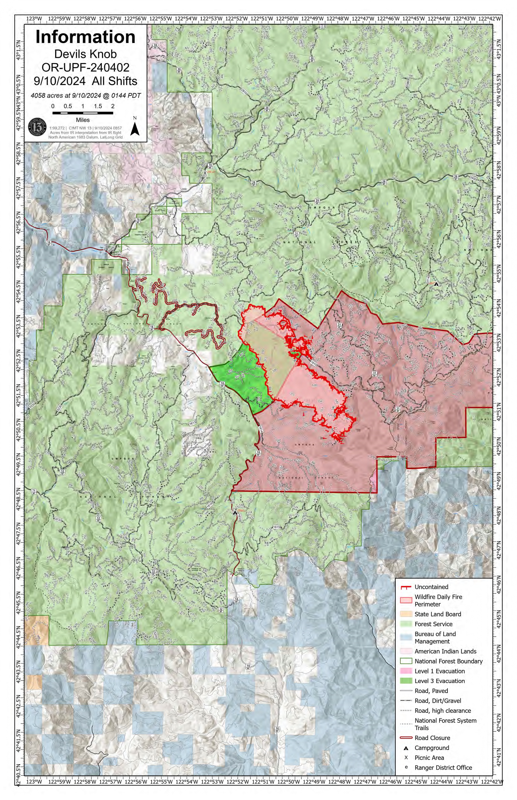
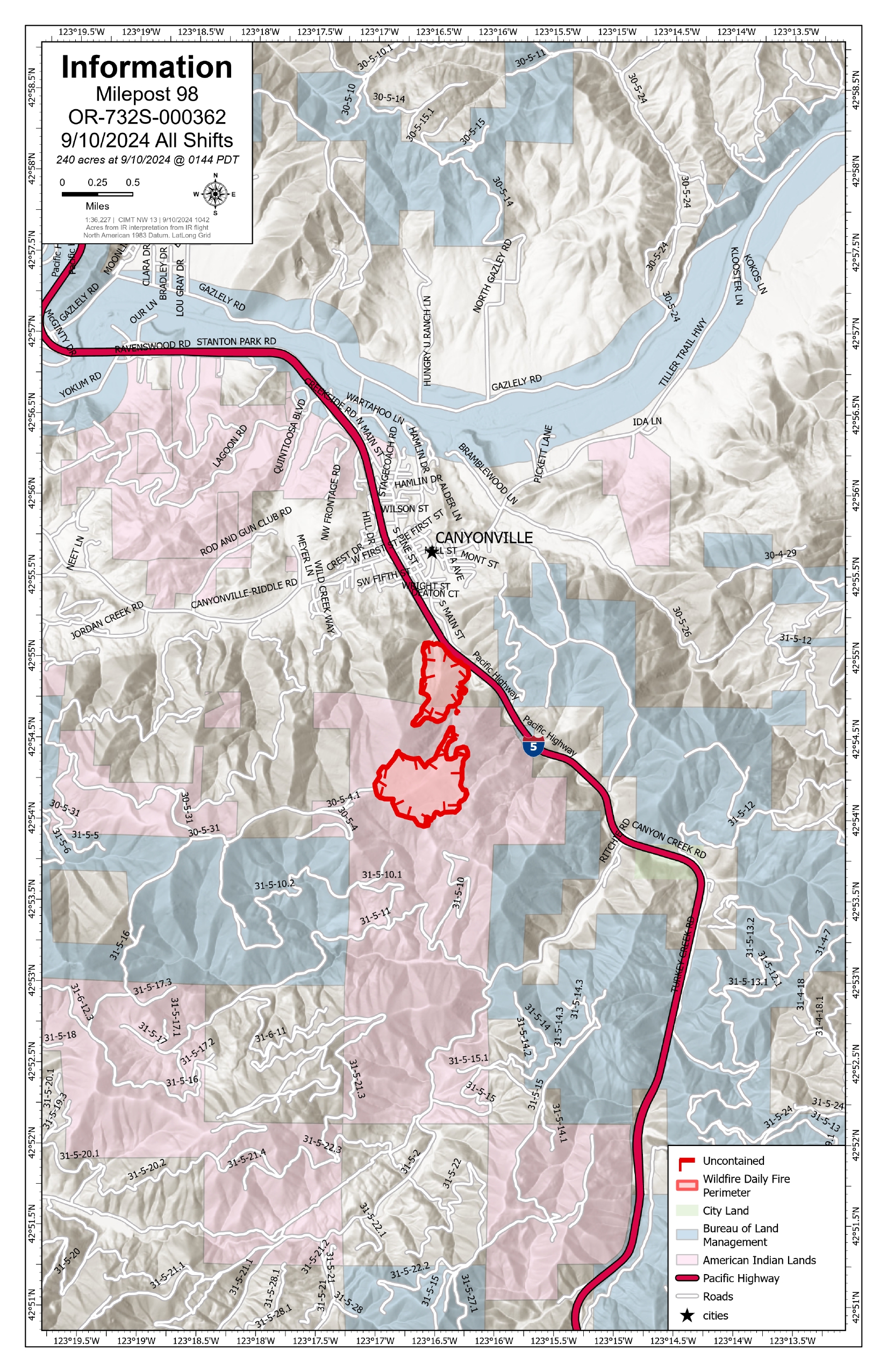
Devil’s Knob and Milepost 98 Fires Update for Tuesday, September 10, 2024
KEY MESSAGES:
CIMT NW 13 will be holding a public meeting tomorrow at 7:00 pm at the South Umpqua Community Church; 27292 Tiller Trail Hwy, Days Creek, OR 97429. The community will be provided a briefing by the Incident Management Team and Agency Administrators from local units on the fire management strategy, objectives, and tactical operations. This meeting will be recorded and posted to Facebook for those unable to attend.
Delays along the Interstate-5 corridor are currently minimal as suppression work on Milepost 98 is being completed. For updated travel information, please visit https://www.tripcheck.com/.
CURRENT STATUS:
Devil’s Knob
There is still extensive interior heat within the Devil’s Knob fire perimeter. Firefighting crews are working direct along the southern half of FS road 1610 with assistance from heavy equipment and aerial resources. Fire growth has predominantly been in the Flat Creek drainage within the Forest boundary. Crews today will be working to mop-up the southeast portion.
Milepost 98
There are no new spot fires along the I-5 corridor. Fireline is being tied together with dozer and handline established in previous shifts. Portions of the southeast flank of the Milepost 98 perimeter are being mopped up after holding line, this operation was assisted by bucket drops from helicopters, stopping forward fire progression. Acreage has been updated from last night due to better mapping.
WEATHER / FIRE BEHAVIOR:
Today will bring slightly cooler temperatures than in previous days though winds are expected to increase in the evening. Mostly sunny skies within the fire area will lead to visible smoke production.
SAFETY AND CLOSURES:
Closures on the Umpqua National Forest can be found at https://www.fs.usda.gov/alerts/umpqua/alerts-notices. These alerts show the official closure orders with listed roads and trailheads, as well as maps of the closed areas.
Multiple evacuations have been established in the fire area. These evacuations are coordinated by the Douglas County Sheriff’s Office. An interactive map can be found at their website, https://www.dcso.com/EVACUATIONS. Residents are encouraged to sign up for emergency notifications through Douglas County Emergency Management, found at https:// www.dcso.com/254/Emergency-Notification-System. The Red Cross has pre-positioned supplies in Days Creek if a shelter is needed. Staff and volunteers remain available for activation where requested.
Actualizacin del incendio Whisky Creek Sandstone y Blister Creek 09 10 2024
Related Incident: Whisky Creek FireSandstone Fire
Publication Type: News
Tamaño de Whisky Creek: 2,977 acres | Fecha de inicio: 20 de julio |Causa: De orígen humano |Contención 25%
Tamaño de Sandstone: 702 acres | Fecha de inicio: 5 de agosto | Causa: Rayo | Contención 75%
Total de recursos: 300 | Equipos de obreros: 4 | Camiones de bomberos: 7 | Topadoras: 2 | Maquinarias pesadas: 11 | Helicópteros: 3
Los incendios Whisky Creek, Sandstone y Blister Creek arden en un terreno escarpado y escabroso en el Bosque Nacional Mt. Hood, donde los escombros rodantes y los árboles que han sido debilitados por el fuego dificultan el trabajo de extinción. Se ha logrado mucho trabajo en los incendios, y hay una alta probabilidad de que se podrá contener el fuego dentro del área actual. Se prevé que crecerá un poco debido a las condiciones meteorológicas previstas.
Whisky Creek: Ayer, las temperaturas más frescas y la mayor humedad minimizaron la intensidad del fuego, y creció solo un poco en las aguas cabeceras de Herman Creek. Las cuadrillas removieron y esparcieron escombros leñosos que ya se habían cortado sobre un sitio de aterrizaje temporal para helicópteros, e hicieron los mismo en las líneas de mano para evitar la erosión antes de la lluvia pronosticada. Los bomberos conectaron y probaron una manguera colocada desde el lago Wahtum hasta la manguera principal en el extremo sureste del incendio. Los helicópteros llegaron para retirar el equipo de transmisión de radio, completaron una misión de reconocimiento y ayudaron en otros incendios cercanos, incluyendo uno nuevo.
Hoy, las cuadrillas continuarán reparando la línea de topadoras y la línea de mano y las maquinarias pesadas participarán en nivelar las carreteras del Servicio Forestal (FSR) 2018 y 2810 hasta el embalse de Green Point. Se está realizando un plan de contingencias, identificando sitios secundarios para cortafuegos y desarrollando un plan en el caso improbable de que sea necesaria una operación de quema en el futuro. Los encargados del incendio están verificando los puntos de acceso, los peligros, las condiciones de los combustibles y la solidez de los cortafuegos. Todo es parte del proceso de planificación.
Sandstone y Blister Creek: El día de ayer, los bomberos detectaron humo en el incendio Blister Creek y neutralizaron focos de calor en coordinación con el personal en el terreno mediante un helicóptero que vertió un total de 2,000 galones de agua. No se vio humo en el incendio Sandstone. Hoy, las maquinarias pesadas continuarán trabajando a lo largo de la FSR 7015 y las cuadrillas repararán la línea de mano y los sitios de aterrizaje temporal de helicópteros.
Clima: A últimas horas del martes, se desplazarán al área temperaturas más frescas, vientos racheados del oeste y lluvia y persistirán hasta el jueves. Para ver el pronóstico de humo y seguridad, consulte: oregonsmoke.org.
Cierres: Los cierres de áreas permanecerán en el Bosque Nacional Mt. Hood, el Área Escénica Nacional Columbia River Gorge y el Condado de Hood River. Se establecen cierres para la seguridad del público y de los bomberos; La intrusión en un área de cierre puede interrumpir las actividades de extinción y reparación de incendios, poner en peligro vidas y propiedades, y puede resultar en multas. La información de cierre se encuentra en: https://linktr.ee/whisky_creek.2024.
Seguridad: El público juega un papel importante en la prevención del próximo incendio forestal; tenga cuidado con cualquier posible fuente de incendio. Para obtener consejos de prevención, consulte: https://keeporegongreen.org. La TFR sigue vigente para ambos incendios: https://bit.ly/3T59VWv. Las restricciones contra incendios están vigentes dentro del Bosque Nacional Mt. Hood. Se puede ver más información en: https://www.fs.usda.gov/main/mthood/fire.
September 9 2024 Middle Fork Complex Community Meeting 09 10 2024
Related Incident:
Publication Type: Announcement
Click the link to see yesterdays Middle Fork Complex community meeting in Garden Valley, ID.
https://www.facebook.com/61565022204468/videos/3826983814286934