
Incident Publication
Actualizacin del incendio Whisky Creek Sandstone y Blister Creek 09 10 2024
Related Incident: Whisky Creek FireSandstone Fire
Publication Type: News
Tamaño de Whisky Creek: 2,977 acres | Fecha de inicio: 20 de julio |Causa: De orígen humano |Contención 25%
Tamaño de Sandstone: 702 acres | Fecha de inicio: 5 de agosto | Causa: Rayo | Contención 75%
Total de recursos: 300 | Equipos de obreros: 4 | Camiones de bomberos: 7 | Topadoras: 2 | Maquinarias pesadas: 11 | Helicópteros: 3
Los incendios Whisky Creek, Sandstone y Blister Creek arden en un terreno escarpado y escabroso en el Bosque Nacional Mt. Hood, donde los escombros rodantes y los árboles que han sido debilitados por el fuego dificultan el trabajo de extinción. Se ha logrado mucho trabajo en los incendios, y hay una alta probabilidad de que se podrá contener el fuego dentro del área actual. Se prevé que crecerá un poco debido a las condiciones meteorológicas previstas.
Whisky Creek: Ayer, las temperaturas más frescas y la mayor humedad minimizaron la intensidad del fuego, y creció solo un poco en las aguas cabeceras de Herman Creek. Las cuadrillas removieron y esparcieron escombros leñosos que ya se habían cortado sobre un sitio de aterrizaje temporal para helicópteros, e hicieron los mismo en las líneas de mano para evitar la erosión antes de la lluvia pronosticada. Los bomberos conectaron y probaron una manguera colocada desde el lago Wahtum hasta la manguera principal en el extremo sureste del incendio. Los helicópteros llegaron para retirar el equipo de transmisión de radio, completaron una misión de reconocimiento y ayudaron en otros incendios cercanos, incluyendo uno nuevo.
Hoy, las cuadrillas continuarán reparando la línea de topadoras y la línea de mano y las maquinarias pesadas participarán en nivelar las carreteras del Servicio Forestal (FSR) 2018 y 2810 hasta el embalse de Green Point. Se está realizando un plan de contingencias, identificando sitios secundarios para cortafuegos y desarrollando un plan en el caso improbable de que sea necesaria una operación de quema en el futuro. Los encargados del incendio están verificando los puntos de acceso, los peligros, las condiciones de los combustibles y la solidez de los cortafuegos. Todo es parte del proceso de planificación.
Sandstone y Blister Creek: El día de ayer, los bomberos detectaron humo en el incendio Blister Creek y neutralizaron focos de calor en coordinación con el personal en el terreno mediante un helicóptero que vertió un total de 2,000 galones de agua. No se vio humo en el incendio Sandstone. Hoy, las maquinarias pesadas continuarán trabajando a lo largo de la FSR 7015 y las cuadrillas repararán la línea de mano y los sitios de aterrizaje temporal de helicópteros.
Clima: A últimas horas del martes, se desplazarán al área temperaturas más frescas, vientos racheados del oeste y lluvia y persistirán hasta el jueves. Para ver el pronóstico de humo y seguridad, consulte: oregonsmoke.org.
Cierres: Los cierres de áreas permanecerán en el Bosque Nacional Mt. Hood, el Área Escénica Nacional Columbia River Gorge y el Condado de Hood River. Se establecen cierres para la seguridad del público y de los bomberos; La intrusión en un área de cierre puede interrumpir las actividades de extinción y reparación de incendios, poner en peligro vidas y propiedades, y puede resultar en multas. La información de cierre se encuentra en: https://linktr.ee/whisky_creek.2024.
Seguridad: El público juega un papel importante en la prevención del próximo incendio forestal; tenga cuidado con cualquier posible fuente de incendio. Para obtener consejos de prevención, consulte: https://keeporegongreen.org. La TFR sigue vigente para ambos incendios: https://bit.ly/3T59VWv. Las restricciones contra incendios están vigentes dentro del Bosque Nacional Mt. Hood. Se puede ver más información en: https://www.fs.usda.gov/main/mthood/fire.
September 9 2024 Middle Fork Complex Community Meeting 09 10 2024
Related Incident:
Publication Type: Announcement
Click the link to see yesterdays Middle Fork Complex community meeting in Garden Valley, ID.
https://www.facebook.com/61565022204468/videos/3826983814286934
Sharrott Creek Fire Daily Update 09 10 2024
Related Incident:
Publication Type: News
Northern Rockies Team 5, Incident Commander Joe Sampson
Location: Three miles west of Stevensville, Montana
State Date: 8/23/2024
Cause: Lightning
Size: 3,193
Completion: 36%
Total Personnel: 354
Current Status
Crews continue improving constructed line along the northern-most point of the fire near the head of Larson Creek. To the west, crews are using natural barriers to hold the fire within its current footprint. Engines will continue to patrol the fire's eastern edge to check for any areas of residual heat. Crews are using water to cool hot spots and “mop up” along the southern-most point of the fire west towards the St. Mary’s Trailhead. Helicopters will be available to assist ground crews with water drops, as necessary. Fire activity in the Sharrott Creek drainage at 8,200 feet continues to burn pockets of available fuel towards the Bitterroot-Selway Wilderness. Some structure protection measures (pumps and hoses) have been removed along the southeastern edge of the fire perimeter.
Weather and Fire Behavior
Hot and dry conditions are expected to continue today with southwest wind gusts reaching 20 to 25 mph in the valley and higher gusts possible along the ridgetops. Temperatures will remain in the mid to high 70s in the high elevations. The majority of the fire’s movement will be in the upper slopes where dry, subalpine fir has the potential to torch and cause short-range spotting up to ½ mile.
Thermal belts overnight resulted in poor relative humidity of 45 percent; relative humidity recoveries are expected to increase to 75 percent in the following days. A strong system will bring precipitation on Wednesday with up to 2 inches of rain possible in the fire area, followed by a possible cold front which could slow fire activity towards the end of the week.
EVACUATIONS, RESTRICTIONS, CLOSURES
-The Ravalli County Sheriff’s Office has issued an Evacuation Warning for neighborhoods in the vicinity of the Sharrott Creek Fire. Sign up for evacuation alerts at http://hyper-reach.com/mtravallisignup.html
- Area closures are in effect from North Fork Sweeney Creek to Sweathouse Creek. More information on Bitterroot National Forest area closures can be found at: https://www.fs.usda.gov/alerts/bitterroot/alerts-notices
- The Bitterroot National Forest is currently in Stage I Fire restrictions within the Anaconda Pintler Wilderness.
- A Temporary flight restriction (TFR) is in place west of Highway 93 from Bass Creek to Big Creek.
Tuesday September 10 2024 RailroadDaly Fire Update and Map 09 10 2024
Related Incident:
Publication Type: News
CURRENT STATUS
Fire managers, working in coordination with the Granite County Sheriff’s Office, have recommended an evacuation warning for the properties closest to the fire’s edge on the northeastern flank. This evacuation warning includes the Gem Mountain area and nearby ranches, south and east of Stony Creek, south and west of Rock Creek Road, and north of Hwy 38. The evacuation warning is necessary, given the recent fire progression and the predicted weather conditions for today.
The Daly Fire continued to advance with primarily northeasterly wind-driven movement. There was further progression with isolated spotting and torching northeast of Stony Creek along the Ravalli and Granite County lines. The spot fire two miles north of the Daly Fire is expected to connect into the main fire in the coming days. Further spotting may occur in the area. Firefighters are assessing the values at risk north of the fire and determining point protection strategies to ensure the safety of the campgrounds, bridges, and other property. These tactics may include placement of sprinklers, portable pumps, hoses, structure protection kits and ensuring safe egress for responders.
The Railroad Fire has limited growth due to reaching areas with limited vegetation and continuous rock scree.
WEATHER AND FIRE BEHAVIOR
Thermal belts overnight resulted in poor relative humidity recoveries. Today, hot, dry conditions are expected with southwest wind gusts reaching up to 25 mph along the ridgetops. Temperatures will be mid-70s to mid-80s with humidities in the mid-20s. Most of the fire’s movement will be on the upper slopes.
In the coming days, precipitation is expected with up to 1 inch of rain possible in the fire area. This wetting rain is expected to impede the fire’s ability to move substantially until fuels along the fire’s perimeter dry out. There remains potential for thunderstorms to cause new fire starts.
EVACUATIONS, RESTRICTIONS, CLOSURES
The Skalkaho Highway (Highway 38) is closed from Black Bear Campground to the Crystal Creek Campground on the Beaverhead-Deerlodge NF side. This location has the potential to change, given the amount of recent fire activity. The temporary flight restriction (TFR) on the Railroad-Daly fire has expanded significantly eastward. Gird Point Lookout is also closed. The Anaconda-Pintler Wilderness in the Bitterroot National Forest is currently in Stage I Fire restrictions.
Coffee Pot Daily Update 09 10 2024
Related Incident: Coffee Pot Fire
Publication Type: News
Unified Command: CAIIMT15 & CAL FIRE
Fire Size: 13,524 acres
Percent Contained: 37%
Primary Strategic Control Line: 96%
Personnel: 1,368
Cause: Lightning
Start Date: Saturday, August 3, 2024, at 10:05 a.m.
Location: Southeast of Three Rivers, CA
Tulare County Sherriff’s Office has announced the evacuation warnings for the following areas TLC-E128-A, TLC-E093-A and TLC-E093-B, have been LIFTED. The area includes north of South Fork Drive, west of East Fork Kaweah River, east of Salt Creek Road and south of Craig Ranch Road.
Evacuation ORDERS have been reduced to WARNINGS for the following areas: TLC-E094-B, TLC-E094-C, TLC-E094-D and TLC-E094-E. The area includes Case Mountain area, just north of Mineral King Road, east of Oak Grove and west of the Park Boundary line. Due to fire conditions in the area, there will be road closures along Mineral King Road, between Oak Grove and the National Park Boundary. For public safety reasons, the access through Mineral King Road may be limited by fire activity, and there may be significant time delays. This will be in effect until further notice and can change at any time.
CURRENT SITUATION: Yesterday, with warm temperatures and low humidity, a small portion of the fire crossed the control line east of Eden Creek Grove. Air operations quickly responded with targeted water drops to suppress the breach, while hotshot crews promptly built direct control lines around the area. Along Horse Creek, additional retardant was applied, and during the night shift, drones conducted controlled burns to reduce fuel, ensuring a low-intensity, slow-moving fire within control lines. Air operations flew the southern and western flanks, reporting minimal heat, while crews backhauled equipment and continued road rehabilitation efforts.
Today, crews will focus on strengthening handlines from Horse Creek to the East Fork Kaweah River. Hotshots will reinforce control lines around areas where the fire crossed the containment lines, with air operations providing water suppression and retardant support as needed. Firefighters will extend mop-up efforts deeper into the burned areas along the southern and western flanks while crews continue hazardous tree removal and road rehabilitation.
WEATHER: High pressure will maintain hot and dry conditions for another day before a cooling trend begins mid-week. Winds will shift to an up-canyon flow by mid-morning, gradually strengthening throughout the afternoon. Expect sunny skies in the morning, with some cloud cover in the afternoon that could limit peak temperatures. By evening, winds will shift to a downcanyon flow, bringing cooler air into the area.
SMOKE IMPACTS: Increased smoke can be expected from fire activity in the Eden Creek area. Owens Valley may see MODERATE conditions this afternoon. Areas closest to the fire; Three Rivers, Hammond, and Giant Forest will continue to see overall MODERATE conditions this morning, with clearing in the late afternoon as the plume lifts, then smoke settling back down in these areas overnight. For more information on current wildfire smoke impacts in your community, please visit AirNow.gov or fire.airnow.gov.
EVACUATION NOTICES: The Tulare County Fire Department has issued Evacuation WARNINGS for zones TLC-E094-B, TLC-E094-C, TLC-E094-D, TLC-E094-E, and TLC-E095. To find your zone, please refer to: protect.genasys.com
FIRE INFORMATION: A Public Information Officer will be at the Three Rivers Village Market daily from 10:30 a.m. to 4 p.m. to provide fire information and answer questions.
BLM AND PARK CLOSURES: The portion of South Fork Drive within Sequoia and Kings Canyon National Parks and trails accessed from the road, including the Ladybug and Garfield Grove Trails, are closed. Recreational access to the Mineral King area of Sequoia National Park is closed to the public. This applies to Mineral King campgrounds, trailheads, and area trails. All other areas of the parks are open but are likely to be impacted by varying levels of smoke and poor air quality. Park closure information is available online at nps.gov/seki. The Bureau of Land Management has also issued a closure of the Case Mountain Extensive Recreation Management Area at blm.gov/press-release.
PUBLIC NOTICE: Wildfires are a no-fly zone for unauthorized aircraft, including drones. If you fly, we can’t. For more information, visit knowbeforeyoufly.org.
West Mountain Fires Daily Update September 10 09 10 2024
Related Incident: Boulder FireDollar Fire
Publication Type: News
Boulder Fire, 6 miles SW of Cascade, 8,799 acres, 24% contained, https://tinyurl.com/ycdfv3tv
Snag Fire, 11 miles E of Cascade 33,139 acres, 15% contained, https://tinyurl.com/4k9dk3mu
Dollar Fire, 18 NE of Cascade, 4,338 acres, 8% contained https://tinyurl.com/bef6r3tz
Goat Fire, 11 miles SE of Cascade, 21,449 acres, 0% contained, https://tinyurl.com/2h4a3dvr
Cause:
Lightning (All Fires)
Total Incident Personnel
1053
Special Note: There will be a COMMUNITY MEETING TONIGHT at 7pm at the Cascade Fire Department, 109 E. Pine St., Cascade. Operations and evacuation information will be shared.
Due to the growth of fires and the joining of the Boulder and Lava Fires, containment needs to be reassessed and will be updated as soon as possible.
EVACUATIONS: GO evacuations were expanded into Zone 6 yesterday (in addition to Zone 4 and 5) and 7 through 11 and Snag 2 are in SET status. For more: check Valley County Sheriff’s Office Facebook or call dispatch at 208-382-5160.
Weather and Fire Behavior:
Yesterday’s fire behavior was less active than expected, and this was in part due to a change in wind direction that brought more smoke from the Lava Fire, settling over the valley and tampering fire behavior. There was creeping and smoldering with some torching in the more active areas. Today, fire behavior will be contingent on smoke dispersal and wind. If smoke clears out there could be very active fire behavior and growth. An increase in behavior could occur quickly as the inversion lifts. Winds are forecasted to be stronger today, with potential for gusts up to 25 mph.
A FIRE WEATHER WATCH has been issued for tomorrow, Sept 11 for expected thunderstorm activity. These storms could bring rain but also lightning. A cold front will start coming through the area beginning Wednesday, with more significant chance of moisture as the week progresses. Sunday will again bring warmer weather.
Boulder Fire: “Go,” “Set,” and “Ready” evacuation orders are in effect. Learn more: Valley County Sheriff on Facebook.
- During the very active fire day of September 8, the neighboring Lava Fire progressed north and east and joined to the west side of the Boulder Fire. There is a Complex Incident Management Team arriving to assume command of the Lava fire, and decisions around management responsibilities of the two fires will be finalized soon.
- Firefighters are conducting strategic firing operations to the north of the Boulder Fire to help stop fire progression into the Willow Creek and Westside Cascade areas, utilizing both hand ignitions and UAS (unmanned aerial systems). Crews continue to prep structures in this neighborhood and are constructing dozer line to protect homes.
- On the west side of Cascade Lake, the Lava Fire has pushed over the 435 Road toward the Deer Creek Rd. (This is in evacuation zone 6). The fire is beginning to back down the ridge toward the lake. Firefighters from the Boulder Fire are assessing for structure protection options and are removing fuels, constructing dozer line, and placing sprinkler systems near structures.
Dollar Fire:
- The Dollar Fire remains in “monitor” status and will be monitored by air.
Snag Fire:
- Warm Lake Road area still has some “roll out” activity (burning logs that roll downhill and can start other fires), so firefighters continue to patrol and mop up.
- The east side shows some creeping and smoldering behavior but is overall holding in the old burn scars with little movement. Structure protection continues near the Fish Hatchery and the values in this area.
- Masticators continue working along the 474 Road.
Goat Fire:
- On the NW side, the Goat Fire has looped around the old Skunk and East burn scars and is in between the 099 Road and the 417 Road. Fire has not reached the 409 Road.
- Crews are scouting a possible fire line running NW to SE, tying the 409 to the 417. This would create a holding feature if strategic firing operations become necessary to help protect the Horsethief area.
- Structure groups are assessing structures in the Horsethief area and generating protection plans.
- On the NE, the fire has pushed through the drainages and met the old Yellow and Shasta burn scars.
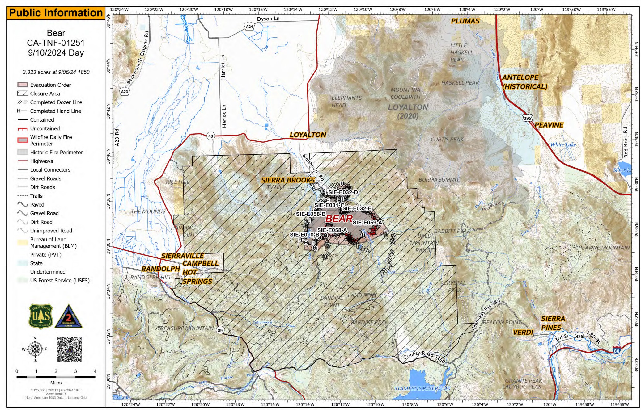
Bear Fire Incident Update 09 10 2024
Related Incident: Bear Fire, Tahoe National Forest
Publication Type: News
Location: South of Sierra Brooks off Bear Valley Rd., Tahoe National Forest
Personnel: 512
Start Date: 9/2/2024 @ 2:00 PM Cause: Undetermined
Size: 3,325 acres Percent contained: 45%
Yesterday, crews continued their efforts to repair the areas that were impacted by fire suppression in the southeast region of Smithneck Road and 56 Road. These activities include mitigating long-term environmental impacts and facilitating the restoration of the affected landscape. Firefighters are working on approximately 61 miles of dozer lines, 11 miles of road, and 12 miles of hand lines will require suppression repair to be completed.
Today, the fire perimeter is expected to remain within its current footprint. Several sections of the fire-affected area have transitioned to patrol status, indicating significant progress in containment. Firefighters will persist in containment efforts and closely monitor the contained sections to prevent wind-driven interior fires from escaping the perimeter. The western Sierra Nevada area near Reno is currently experiencing Red Flag conditions, characterized by dry weather, low humidity, and strong winds, which increase the risk of wildfires. While the Bear Fire is not currently situated within a Red Flag area, its proximity to these conditions and the possibility of similar weather patterns affecting the region could lead to increased fire activity. Mop-up and repair operations will continue, employing heavy equipment such as dozers, chippers, and excavators.
Several evacuation zones have been downgraded to normal status with the fire's containment progressing. However, an evacuation order persists within the fire perimeter, and the area remains inaccessible to the public. It is imperative to remember that Forest Closures and Evacuation Orders remain in place to safeguard both the public and firefighters. Any unauthorized entry into these restricted areas is strictly forbidden.
WEATHER:
Wind speeds are expected to increase as a cold front approaches on Wednesday. Winds of 25 mph are expected today in the fire area.
EVACUATIONS:
Sierra County: Evacuation order and warnings remain in effect. For an interactive map of evacuations, visit: https://protect.genasys.com/search.
FOREST CLOSURE:
A forest closure has been issued, For more information visit the Tahoe National Forest website at: https://www.fs.usda.gov/alerts/tahoe/alerts-notices.
Wapiti Fire Information Popup Lowman September 10 09 10 2024
Related Incident:
Publication Type: Announcement
Public Information Officers from the Wapiti Fire Information Section will be at the Lowman Mercantile (7263 ID-21, Lowman, ID 83637) today from 3-5pm! Please come visit and ask any questions.
Whisky Creek Sandstone and Blister Creek Fire Update 09 10 2024
Related Incident: Whisky Creek FireSandstone Fire
Publication Type: News
Northwest Team 12
Whisky Creek, Sandstone and Blister Creek Fires
Sept. 10, 2024
Fire Information: (541) 208-1743, 8 AM - 8 PM
For links to incident information: https://linktr.ee/whisky_creek.2024
Whisky Creek Size: 2,977 acres | Start Date: July 20 | Cause: Human | Containment: 25%
Sandstone Size: 702 acres | Start Date: August 5 | Cause: Lightning | Containment 75%
Total Resources: 300 | Hand Crews: 4 | Engines: 7 | Dozers: 2 | Heavy Equipment: 11 | Helicopters: 3
The Whisky Creek, Sandstone, and Blister Creek Fires are in steep and rugged terrain on the Mt. Hood National Forest where rolling debris and fire-weakened trees challenge firefighting efforts. Much work has been accomplished on these fires, and there is a high probability of success in confining the fire within the current footprint. Minimal growth is anticipated given the forecasted weather conditions.
Whisky Creek: Cooler temperature and higher humidity moderated fire activity yesterday with only slight growth in the headwaters of Herman Creek. Crews cleaned up and scattered previously cut woody debris over a temporary helicopter landing site as well as hand lines to prevent erosion ahead of forecasted rain. Firefighters connected and tested a hose lay from Wahtum Lake to the main hose lay on the southeast side of the fire. Helicopters flew in to remove radio transmission equipment, completed a reconnaissance mission, and supported other nearby fires, including a new fire start.
Crews will continue dozer line and hand line repair today and heavy equipment will engage in road grading on Forest Service Road (FSR) 2018 and 2810 up to Green Point Reservoir. Contingency planning is ongoing, identifying secondary fireline locations and developing a plan in the unlikely event a firing operation is necessary in the future. Fire managers are verifying access points, hazards, fuel conditions, and viability of firelines, all as part of the planning process.
Sandstone and Blister Creek: Firefighters detected smoke on the Blister Creek Fire yesterday and mopped-up hotspots in on the ground coordination with a helicopter dropping a total of 2,000 gallons of water. No smoke was observed on the Sandstone Fire. Today, heavy equipment will continue to work along FSR 7015 and crews will repair hand line and temporary helicopter landing sites.
Weather: Cooler temperatures, gusty west winds, and rain will move into the area by late Tuesday and linger through Thursday. For smoke forecasts and safety, visit: oregonsmoke.org.
Closures: Area closures will remain in the Mt. Hood National Forest, Columbia River Gorge National Scenic Area, and Hood River County. Closures are put into place for the safety of the public and fire crews; intrusion into a closure area can disrupt fire suppression and repair activities, endanger lives and property, and can result in fines. Closure information is at: https://linktr.ee/whisky_creek.2024.
Safety: The public plays an important role in preventing the next wildfire; please use caution with all potential ignition sources. For prevention tips see: https://keeporegongreen.org. The Temporary Flight Restriction remains in effect for the Whisky Fire: https://tinyurl.com/2s49yrj4. Fire restrictions are in place on the Mt. Hood National Forest: https://www.fs.usda.gov/main/mthood/fire.
West and Preacher Fires Update 09 10 2024
Related Incident: 2024 - West Fire - TNF2024 - Preacher Fire - TNF
Publication Type: News
Crews continue to ignite and patrol
Highlights/Operations: Yesterday conditions were favorable for burning. On the West Fire, firefighters worked east on Milk Ranch Road from the Webber Creek drainage adding fire inside the containment lines to consume the buildup of fuels. They also used UAS and a helicopter with ignition capabilities for efficiency and safety in the challenging terrain of East Webber Creek. On the Preacher Fire, firefighters were able to add fire along the Control Road south of Tonto Village all the way down to the powerlines. They also worked igniting off Diamond Point Road near the Diamond Point Summer Homes southwest to the natural fire’s edge. The interior was ignited by a helicopter. On both fires, the fire behavior continues to be moderate which is helping restore the ecosystem and consuming fuels that otherwise may threaten communities in the future.
Today, firefighters will continue with ignitions on both fires. On the West Fire, the goal is to establish fire across the northwest corner of the planned perimeter before proceeding to ignite additional areas. This ignition pattern is designed to moderate fire intensity as they move east with fire, given the predicted winds out of the southwest. Engines are continually testing watering systems around Bray Creek Ranch, Camp Geronimo and Geronimo Estates to be ready if needed. They are also improving the hand line and dozer line east of Pine and masticating fuels along the Control Road from Bray Creek Road to SR 87. On the Preacher Fire, ignitions will continue down the powerline on the southern side of the planned perimeter and south towards Diamond Point on the northern side of the planned area. Engines will patrol the perimeters and staff watering systems around structures through the night.
Weather: An isolated shower or thunderstorm may develop on the Mogollon Rim Tuesday afternoon but is not expected to reach the West fire. Otherwise, Tuesday will be seasonably warm and dry with light winds. Southwest winds are forecast to increase by Wednesday and Thursday, with frequent afternoon gusts to 25 mph on Wednesday and even up to 30-35 mph on Thursday.
Safety: Two Temporary Flight Restrictions (TFR) are now in place over the area, which includes uncrewed aircraft systems or drones. The public is reminded, if you fly we can’t; unauthorized drone flights pose serious risks to firefighter and public safety and the effectiveness of wildfire suppression operations.
Closure: The Tonto National Forest has issued a closure for land surrounding the West Fire, this includes Pine Trailhead.
Evacuations: Some residents east of Payson near the Preacher Fire have been moved to SET status, additionally yesterday, Geronimo Estates have also been placed in SET status. An interactive map is available to stay up to date with evacuation levels related to both the West and Preacher Fires.
Receive emergency notifications from Gila County.
Smoke: During ignitions, smoke may settle in low-lying areas overnight. Residents are encouraged to close windows at night to avoid smoke impacts. Talk with your doctor and plan for how to manage your health conditions when it is smoky. Additional resources for how to prepare for wildfire smoke.
For the latest news and information about the Tonto National Forest, follow along on Facebook @TontoNationalForest, ‘X’ (formerly Twitter) @TontoForest or Instagram @tontonationalforest and on the Tonto National Forest website.