
Incident Publication
Park Fire Update Tuesday 09 10 2024
Related Incident: Park Fire
Publication Type: News
Park Fire Update: Tuesday, September 10, 2024
Southwest Complex Incident Management Team 2
Incident Commander John Truett
Size: 429,603 acres
Start Date: July 24, 2024
Containment: 99 percent
Total Personnel: 485
Resources: 1 helicopter, 4 crews, 6 engines, 2 dozers, 10 water tenders, 2 chippers, 8 excavators, 2 feller bunchers, 3 skidders, 1 log loaders, 1 backhoe, 4 road graders
CURRENT SITUATION: Southwest Complex Incident Management Team 2 (SWCIMT2) will be transferring command of the fire on Thursday, September 12. New fire managers will arrive today, receive a briefing, and begin the transition with SWCIMT2, gathering information that will facilitate the change of command. Tomorrow’s update will be the final update from SWCIMT2. Thereafter, the Lassen National Forest public affairs officer will be the point of contact for Park Fire information. Today will be the final day that information is posted on community boards. The incident will be managed with fewer personnel and resources, but fire-suppression repair work will continue.
WEATHER & FIRE SAFETY: Winds today will be picking up again. Temperatures continue their downward trend reaching highs only in the 80s today. Despite this, relative humidity remains stubbornly low. These conditions encourage the spread of any new fires, so be particularly cautious while recreating and using equipment outdoors and be aware of applicable fire restrictions. Stumps and snags do continue to smolder and occasionally burn within the Park Fire perimeter; interior smoke might be visible but poses no danger. Hazy, smoky skies are the result of fires in other states. Get air-quality information for your area and view a smoke map here: tinyurl.com/ypkfbkyn.
FOREST CLOSURE: Some Lassen National Forest lands, roads, and trails remain temporarily closed for the safety of the public and firefighters during the repair phase of the fire. Prior to recreating on your public lands, view Forest Order No. 06-24-07 and the map here: fs.usda.gov/alerts/lassen/alerts-notices. Knowing the forest-closure status in the areas where you are working or recreating is your responsibility.
FIRE RESTRICTIONS: Fire restrictions remain in effect throughout the area. For details, view Forest Order No. 06-24-04 here: fs.usda.gov/alerts/lassen/alerts-notices. Find links to other land management agencies’ restrictions in the Park Fire Information Linktree (URL and QR code below). Knowing fire restrictions in the areas where you are living, working or recreating is your responsibility.
![]() Park Fire Information (Southwest CIMT 2): 530-414-9298 | 2024.park@firenet.gov
Park Fire Information (Southwest CIMT 2): 530-414-9298 | 2024.park@firenet.gov
Park Fire Linktree (fire information website links): linktr.ee/park_fire
Lassen National Forest Supervisor’s Office: 530-257-2151
Line Fire Daily Status Update for 09 10 2024
Related Incident: Line Fire
Publication Type: News
Situation Summary
The north and east sides of the Line Fire continue to burn with the greatest intensity. Today will be mostly sunny over the fire area, and the smoke impacts are expected to grow as the day progresses. A local Red Flag Warning goes into effect in the area from 11:00am to 8:00pm. There will be gusty winds over the fire which will lead to low humidity and very dry vegetation. Firefighters are creating control lines, protecting structures and the community, making contingency plans, and maximizing the use of aircraft when conditions are not too smoky. Tuesday night, stronger winds are predicted which could lead to drops in relative humidity and greater fire spread. Towards the end of the week, cooler weather may moderate fire activity.
There are currently 65,600 structures threatened. This includes 9,200 structures under Evacuation Orders and 56,400 structures under Evacuation Warnings. A Damage Inspection Team (DINS) is working in the area.
Governor Gavin Newsom has announced that the California National Guard will support the state’s ongoing response to the Line Fire in San Bernardino County.
Through its activation, authorized under the Line Fire state of emergencyExternal Link, the California National Guard will deploy:
- Four UH-60 Blackhawk helicopters for water bucket dropping operations
- Two C-130 aircraft with Modular Airborne Fire Fighting Systems (MAFFS)
- Four 20-person hand crews (80 soldiers). They report to Camp Roberts today for equipment distribution and will be assigned to the Line Fire on Thursday in support of CAL FIRE.
- One military police company to support the San Bernardino County Sheriff’s Department with traffic control points in evacuated areas.
For information on the Line Fire, please call (909) 220-4292. The line for media is (909) 881-6949. Additional fire information can be found at: Cabdf Line Fire Information | InciWeb (wildfire.gov)
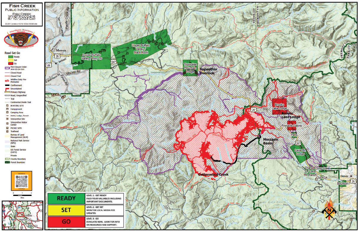
Fish Creek Fire Update Tuesday 09 10 2024
Related Incident:
Publication Type: News
Northern Rockies Team 2, Incident Commander Scott Schuster
Location: 7 miles SW of Togwotee Pass
Start Date: Friday, August 16, 2024
Cause: Lightning
Size: 24,904
Percent complete: 69%
Resources: 504 Total Personnel: 11 Hand Crews; 24 Engines; 17 Heavy Equipment; 3 Helicopters
KEY MESSAGES:
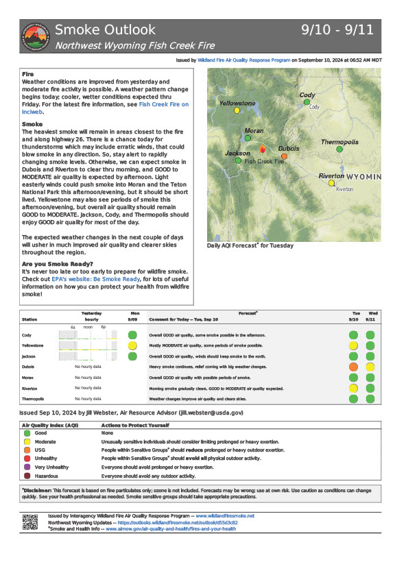
Smoke continues to impact not only the immediate area around the fire but also nearby communities and residents. There will be unhealthy air quality in some locations, especially in low-lying drainages, and roadway visibility could be impacted by the smoke from the fire. Individuals sensitive to higher Air Quality Indexes (AQI) should avoid physical activities outdoors or at least postpone those actions until the air quality improves.
CURRENT STATUS:
Resources overnight supported structure protection operations along the Highway 26/287 corridor.
Today personnel will monitor fire behavior for any potential threats to Highway 26 and other critical values and execute mechanical and hand clean-up work along Deception Road from Highway 26 to Brooks Lake Lodge campground. The moderating weather and fire behavior will allow resources to begin shaded fuelbreak work on the 2-mile stretch of the Upper Flagstaff Road. This work will include clearing the understory vegetation and smaller trees for 100’ on each side of the road. Firewise work has begun around the Towgotee Lodge.
Structure protection work will continue for the Wyoming Fish and Game cabin and outbuildings in the southern portion of the fire. The Cottonwood Creek area continues to generate the largest fire growth and greatest fire behavior on this incident.
WEATHER AND FIRE BEHAVIOR:
Yesterday’s conditions on the fire did meet the minimum criteria for the Red Flag Warning, with wind gusts that met or exceeded 25-30 mph. Today, there is a slight chance of an afternoon shower, and conditions will be cloudier and slightly cooler than recent days. This begins a change in the weather pattern that will culminate in a cold front entering the region during the middle of the week. The moderating weather conditions will reduce active fire behavior.
AIR QUALITY AND SMOKE:
Air quality and dense smoke, continue to be a concern for both residents and visitors to the area around the Fish Creek Fire incident. For up-to-date air quality alerts, current and predicted smoke conditions and ways to mitigate poor air quality, check out the AirNow website at https://www.airnow.gov/.
CLOSURES AND EVACUATIONS:
The joint Closure Order issued by both the Bridger-Teton and Shoshone National Forests for the fire area, remains in effect. Please do not enter the closure area or use any Forest Roads that are closed. For specific details regarding this closure, please reference the Fish Creek Area, Roads, and Trails Closure Order (map) and the Forest website at https://www.fs.usda.gov/alerts/btnf/alerts-notices.
Under the jurisdiction of Fremont County, the areas of Brooks Lake, Pinnacle Drive and Breccia Drive remain under a Level 3 Evacuation notice (Indicated by red blocks on the PIO Incident Map). A Level 3 Evacuation means “Go” to evacuate. Residents must remain evacuated until advised otherwise by Fremont County. See the alert notice on the Fremont County Fire Protection District Facebook page.
The Teton County Division of Emergency Management utilizes a Ready, Set, Go system for evacuation messaging, visit their website for additional details at www.tetoncountywy.gov/1846/Ready-Set-GO. (Indicated by green blocks on the PIO Incident Map.) They advise all residents to be in a “Ready” status by preparing for evacuations and becoming fire adapted.
US HWY 26/287 is open for free-flowing traffic, but motorists may still experience smoke and sometimes limited visibility. A 45-mph speed restriction remains in effect for the fire area. Motorists are encouraged to stay alert for fire personnel and fire vehicles and use caution when travelling through the area. The Wyoming Department of Transportation (WYDOT) continues to work closely with Fremont County Emergency Management, Fremont County Sheriff’s Office and fire officials for the safety of motorists and firefighters. Drivers are encouraged to visit https://www.wyoroad.info/ prior to traveling on US HWY 26/287 for road status and information, or download the Wyoming 511 app at https://www.wyoroad.info/511/WY511Mobile.html to monitor for any changes due to fire activity.
Ruby Fire Update for September 10 2024 09 10 2024
Related Incident: Ruby Fire
Publication Type: News
Ruby Fire Quick Facts
Size: 1300 acres Location: North Cascades National Park, Ruby Mountain, Diablo, Washington
Containment: 0% Cause: Lightning/Natural
Start Date: August 9, 2024 Total Personnel: 61
Fire Information: 360-208-8096
Inciweb: https://inciweb.wildfire.gov/incident-information/wancp-ruby-fire Email: 2024.Ruby@firenet.gov
Current Status: This past weekend’s red flag conditions contributed to slow but gradual fire growth, adding almost 100 acres. Monday, a helicopter supported fire suppression efforts by collecting water from Diablo Lake and dropping it over hot spots on the western edge of the fire, as well as the eastern edge of the fire north of Panther Creek. Smoke was minimal and air quality remained good throughout the day. Panther Creek, Thunder Creek and Happy Creek trails remain closed as these are critical areas for firefighters to stage for fire suppression efforts. Visitors should use extra caution when traveling on State Route 20 (SR20) near Diablo Lake to avoid inhibiting active firefighting operations. Slow down. Please do not stop on the road to watch helicopter and fire operations. The Thunder Arm portion of Diablo Lake and Colonial Creek South Campground are closed.
Planned Actions: Today fire managers intend to utilize helicopters to conduct suppression efforts by strategically dropping water on the fire as needed. Firefighters will continue to focus on protecting critical infrastructure such as campgrounds, SR20, trails, and backcountry camps in preparation for possible fire growth. The Ruby Fire is a full suppression fire, and firefighters are using tactics with the highest chance for success, while reducing safety risks to firefighters and the public.
Weather: Zonal flow aloft on Tuesday will promote increased onshore flow, morning cloud cover, and good humidity recoveries near the fire. The next system approaches the region and pushes inland on Wednesday and may bring a few showers to the area, with latest guidance suggesting a 10-20 percent chance of a wetting rain occurring within the vicinity of the fire.
Closures: There are multiple closures in place for public safety: Colonial Creek South Campground and boat launch, Thunder Arm south of Diablo Lake, Happy Creek Trail, and area trails and camps. See all closures at https://go.nps.gov/fireclosures
Smoke: Air quality is forecast to be GOOD on Tuesday. Forecast at https://www.airnow.gov
Burning Restrictions: Campfires, the ignition of wood, briquettes, or any fuel in fire pits, fire pans and barbeque grills, are banned in all portions of North Cascades National Park Service Complex: North Cascades National Park, Ross Lake National Recreation Area and Lake Chelan National Recreation Area.
Drone Restrictions: If you fly, we can’t. Drones can jeopardize firefighting efforts, and operating drones within North Cascades National Park is prohibited, except with prior written approval from the superintendent.
Cooperating Agencies & Tribes: National Park Service, Upper Skagit Indian Tribe, Seattle City Light, Whatcom County, Whatcom County Sheriff’s Office, Washington State Dept. of Transportation, Washington DNR.
To sign up for our daily updates, please send an email to: 2024.Ruby@firenet.gov Thank you.
Wapiti Fire Update September 10 2024 09 10 2024
Related Incident:
Publication Type: News
Wapiti Fire Update
Tuesday September 10th 2024 – 8:00 a.m.
Great Basin Complex Incident Management Team 7
Mike Johnston, Incident Commander
Wapiti Fire Statistics:
Size:122,233 acres
Containment: 12%
Total Personnel: 1,442
Location: Grandjean, ID
Reported: July 24, 2024
Cause: lightning
For More Information:
Information Phone: 208-593-7132
Email: 2024.wapiti@firenet.gov
InciWeb: https://inciweb.wildfire.gov/incident-information/idbof-wapiti-fire
Facebook: https://www.facebook.com/BoiseNationalForest
Currently the “Wapiti Fire Information 2024” is suspended. Please see the Boise National Forest Facebook page for updated fire information.
Linktree: https://linktr.ee/WapitiFireInfo2024
Interactive Map: https://tinyurl.com/WapitiFireInfoMap
Special Notes: The Custer County Sherriff made a slight reduction in the road closure- State Highway 21 remains closed east of Lowman to Stanley from MP84 (Sourdough Lodge) to MP126 (Stanley Lake turnoff) due to wildfire activity. Highway 75 remains open.
Current Situation: The fire is being managed under a full suppression values-driven strategy. A values driven suppression strategy emphasizes the protection of values at risk while only placing fire personnel in locations where they will have a reasonable probability of success. Firefighter and public safety remain the highest priority in all management decisions. Resources assigned to the Wapiti Fire are supporting initial attack operations on the Frog Fire on the Sawtooth National Forest. Fires are staffed by day, swing and night shifts to support the overall fire suppression plan.
Division DD: The fire in the Sawtooth Wilderness is slowly growing towards the south and east remaining in the drainage bottoms with rocky alpine terrain above it. Minimal resources are staffed in this division due to the limited access within the Wilderness and low fire potential.
Division HH: Crews remain in the area to complete mop up operation and watch for any spot fires. An Unmanned Ariel System (UAS) was utilized in the Iron Creek area to locate hot spots using infrared detection.
Division KK and Structure Group East: Structure protection remains in place and crews continue to monitor the communities and ensure there is no fire progression.
Divisions PP & MM: Burn operations continued throughout the day along the Hwy 21 corridor. Crews continue to patrol and monitor the area, securing the line, and mopping up and gridding 500 ft into the interior. Crews are staged for structure protection needs. An Unmanned Ariel System (UAS) was utilized on Cape Horn to locate hot spots using infrared detection. Crews continue to monitor in the Bull Trout area.
Division WW and Structure Group West: Above 8-mile Ridge, aviation resources continue to support suppression in the area. Structure prep is complete along the Highway 21 corridor and the structure protection group remains in place to take further action if needed.
Division VV: Fire in this division is burning partially within the Sawtooth Wilderness and is unstaffed due to the lack of road access.
Weather, Fuels, and Fire Behavior: For today, a Red Flag warning has been issued for hot, dry and windy conditions. For Wednesday a fire weather watch is issued for thunderstorms with lightning and wind gusts up to 60 mph arriving around 3 pm. Starting Wednesday afternoon, a strong change in weather pattern will be present over the fire area. This storm is expected to produce up to an inch of rain with winds out of the north and northwest.
Evacuations:
For evacuation information on the Wapiti Fire, please see the Custer County Sheriff’s Facebook page at https://www.facebook.com/p/Custer-County-Sheriff-Idaho-61558947312289/ and the Boise County Sheriff’s Facebook page at https://www.facebook.com/boisecountysheriff/.
To sign up for Custer County CodeRED emergency notifications, text CUSTER to 99411 or enroll online at https://public.coderedweb.com/CNE/BF28E45537FF .
To sign up for Boise County Alert Sense emergency notification enroll online at https://public.alertsense.com/SignUp/publicUser.aspx?regionid=1163
Closures and Fire Restrictions:
State Highway 21 remains closed from MP84 to MP126 for public and firefighter safety.
A Wapiti Fire Area Closure / Forest Order: 0414-04-151 for portions of the Boise, Sawtooth, and Salmon-Challis National Forests can be found at this site: https:/www.fs.usda.gov/alerts/sawtooth/alerts-notices
Boise National Forest Stage 1 Fire Restrictions / Forest Order: 0402-00-63 can be found at this site: https://www.fs.usda.gov/alerts/boise/alerts-notices
Sawtooth National Forest Stage 1 Fire Restrictions / Forest Order 0414-00-044 can be found at this site: https://www.fs.usda.gov/alerts/sawtooth/alerts-notices
Fire restrictions on federal, state, and private lands may be found at this site: https://www.idl.idaho.gov/fire-management/fire-restrictions-finder/.
A Temporary Flight Restriction is in place over the Wapiti Fire. Wildfires are a no-fly zone for unauthorized aircraft, including drones. If you fly, we can’t. For more information, visit http://knowbeforeyoufly.org.
Daily Update for the Chimney Fire 09 10 2024
Related Incident: Chimney Fire
Publication Type: News
Gusty winds and fire conditions lead to active fire growth
Daily Update – Tuesday, September 10, 2024
Acres: 6,140
Start Date: 9/2/2024
Location: 9 miles northwest of Fairfield, ID
Personnel: 422
Containment: 10%
Fuels: Timber, brush, grass, understory
Highlights: A community meeting will be held on Thursday evening to present fire information and provide an opportunity for the public to ask questions. It will be held at the Camas County Senior and Community Center located at 129 West Willow Street in Fairfield at 6:00 pm.
Operations: Firefighters continue work to secure the Middle Fork and South Fork of Lime Creek. Fire has advanced into the Stewart Creek Fire footprint from 2018, influenced by the southwestern winds in alignment with the terrain. Active heat remains along the northeastern and northwestern flanks, burning through bands of dead and down timber. Aerial observation was difficult due to thick smoke. Helicopter support continues along the northwestern section of the fire today. Hot spots along the Lime Creek drainage will also be addressed and the southern perimeter will be reinforced to protect values at risk. Firefighters continue to scout for potential control features. Additional firefighters will also be available for any new fire starts in the area.
Weather: Today, temperatures will be in the low 80s with afternoon humidity in the 12 to 19 percent range. Southwest winds in the afternoon will gust in the 20 to 25 mph range. A weather pattern is expected to move into the fire area on Wednesday with colder temperatures and chance of precipitation.
Smoke: Smoke may be visible from the Fairfield area, with continuing predicted today. An interactive smoke map located at https://fire.airnow.gov/ allows you to zoom into your area to see the latest conditions.
Closures: The Sawtooth National Forest has issued an emergency temporary closure of trails and trail segments for the Chimney Fire. The purpose of the closure order is for the protection of firefighters and public during wildfire suppression activities occurring in and around the trails. The full closure order (No. 0414-05-065) and map are available on the Sawtooth National Forest website at https://www.fs.usda.gov/alerts/sawtooth/alerts-notices.
Safety: The health and safety of firefighters and the public are always the first priority. A temporary flight restriction (TFR) is in place over the area, which includes uncrewed aircraft or drones. Flying drones near wildfires is dangerous for pilots and firefighters and can bring wildfire suppression efforts to a halt. Know before you fly. If you fly, we can’t. More information can be found at: https://uas.nifc.gov/.
More Information: https://inciweb.wildfire.gov/incident-information/ideix-chimney-fire /
208-246-8292 / https://www.facebook.com/sawtoothnationalforest / 2024.chimney@firenet.gov / https://www.facebook.com/IdahoDepartmentofLands/
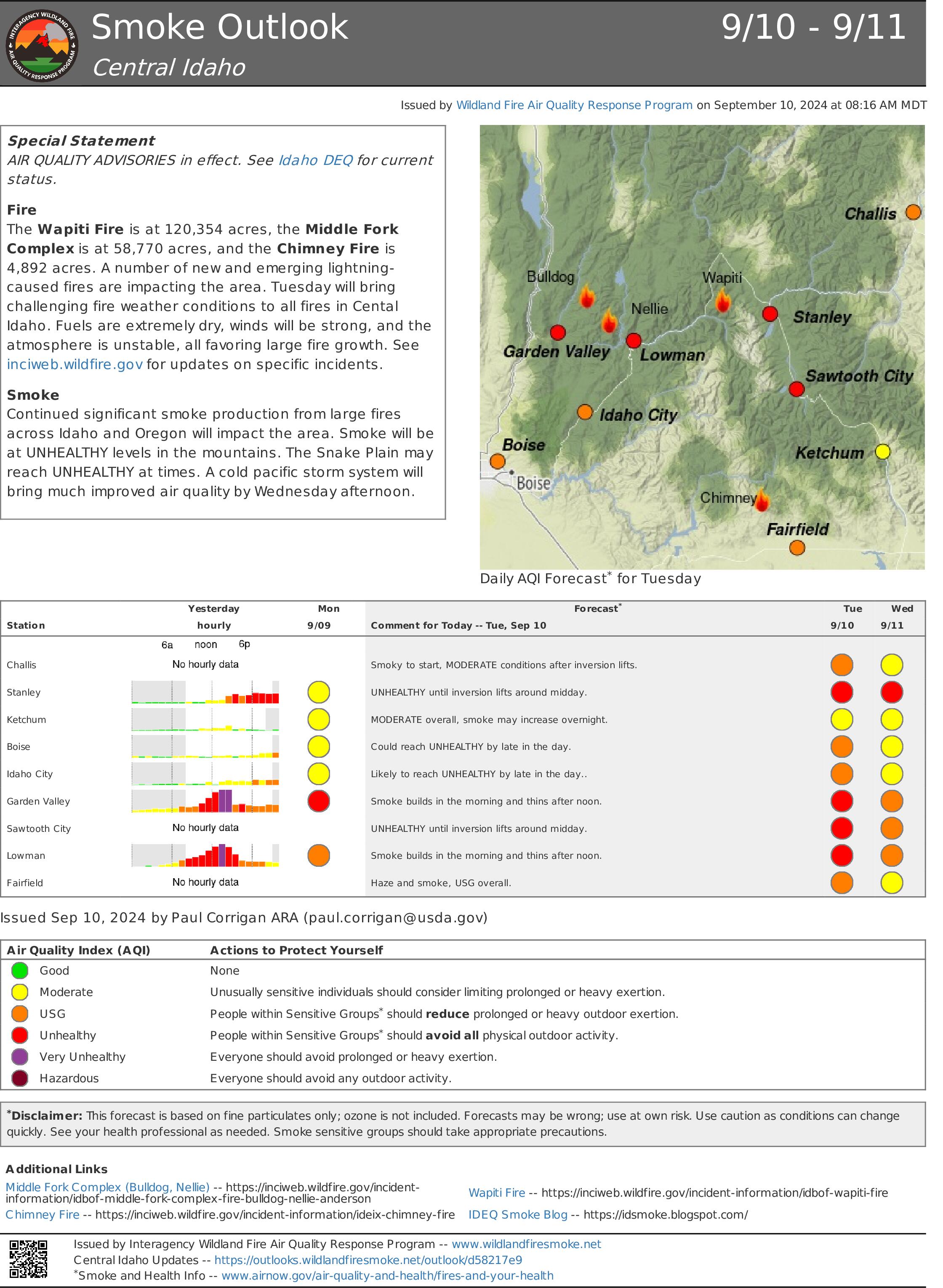
Central Idaho Smoke Outlook 091024 09 10 2024
Related Incident:
Publication Type: News
Special Statement
AIR QUALITY ADVISORIES in effect. See Idaho DEQ for current status.
Fire
The Wapiti Fire is at 120,354 acres, the Middle Fork Complex is at 58,770 acres, and the Chimney Fire is 4,892 acres. A number of new and emerging lightning-caused fires are impacting the area. Tuesday will bring challenging fire weather conditions to all fires in Cental Idaho. Fuels are extremely dry, winds will be strong, and the atmosphere is unstable, all favoring large fire growth. See inciweb.wildfire.gov for updates on specific incidents.
Smoke
Continued significant smoke production from large fires across Idaho and Oregon will impact the area. Smoke will be at UNHEALTHY levels in the mountains. The Snake Plain may reach UNHEALTHY at times. A cold pacific storm system will bring much improved air quality by Wednesday afternoon. View interactive smoke outlook.
Lava Fire Update September 10 2024 09 10 2024
Related Incident:
Publication Type: News
OLA, Idaho, September 10, 2024 – Extreme fire behavior continued on the Lava Fire yesterday. The fire is now approximately 69,658 acres and has merged with the Boulder Fire to the east, for a combined acreage of 78,457 acres.
Today, Southern Area Red Team, a Complex Incident Management Team (CIMT), will in-brief with Wyoming Team 6, the type 3 team currently managing the Lava Fire. A CIMT is mobilized during complex emergency incidents to provide command-and-control infrastructure in order to manage the operational, logistical, informational, planning, fiscal, community, political and safety issues associated with complex incidents. Southern Area Red CIMT will take command of the fire on Thursday.
Yesterday, crews worked to slow fire progression towards Indian Valley by constructing fireline and tying it in with dozer line on the south end of the fire. Fireline is handline that firefighters construct by digging down to the bare mineral soil to hold the fire and keep it from growing. Today, crews will work to tie in those lines on the west side of the fire heading north and scout additional areas to put in fireline between Indian Valley and West Mountain. Heavy equipment and aerial resources will continue to support firefighting operations and fire personnel will implement structure protection strategies. The Forest Service uses all available strategies and tools to suppress wildfires, and public and firefighter safety are the top priorities for fire managers.
Beginning tonight, cooler temperatures with showers and thunderstorms are predicted. A strong system will move in Wednesday and Thursday, bringing stronger winds, cooler temperatures and higher relative humidities, a chance for thunderstorms and potentially heavy rain. Fire Weather Watch is in effect for Wednesday afternoon and evening. A Fire Weather Watch is issued when the combination of dry fuels and weather conditions support extreme fire danger.
Gem County Sheriff’s Office issued LEVEL 3 “GO!” Evacuation notices to residents on Third Fork Road, North of Nesbitt Lane, Nesbitt Lane, Second Fork Road (North of Nesbitt Lane), and Sage Hen Reservoir. The Gem County Sheriff’s Office notified the residences in person on September 8th, 2024.
Gem County Road and Bridge issued the following road closures: Third Fork Road at Nesbitt Lane, and Second Fork Road at Nesbitt Lane. The Sweet-Ola Highway has also been closed at the split to Second and Third Fork Roads. Please be advised that the Gem County Sheriff’s Office is staffing the road closure check points.
Adams County Sheriff’s Office issued LEVEL 3 “GO!” Evacuation notices to residents along Little Weiser Road in Indian Valley to the south of Council, ID. Sheriff deputies have made notifications to residents. Council, ID to the south county line, on the east side of Highway 95 are in LEVEL 2 “SET” Evacuation.
Boise National Forest implemented the Lava Fire Area, Road, and Trail Closure for public and firefighter safety. Visit the Forest Alerts and Notices web page for details.
Visit the Lava Fire InciWeb page at https://inciweb.wildfire.gov/incident-information/idbof-lava-fire for more information. For other news, events and information, visit the Boise National Forest website at https://www.fs.usda.gov/boise and follow the Boise on Facebook @BoiseNationalForest.
Fossil Complex Evening Updatge 09 09 2024
Related Incident: Fossil Complex
Publication Type: News
DRY FUELS IGNITE UNDER LIGHT BREEZES ON THE FOSSIL COMPLEX
SPRAY, Ore. – Westerly winds with gusts to 20 mph were enough to fan dry fuels into very active behavior today on the Service Fire. Torching trees and shifting winds sent firebrands skyward, creating numerous spot fires outside of the main fire body for crews to contend with. An active column was visible from the south as the fire rolled to the east, breeching retardant lines and impacting power lines that serve several communities in the area. The Service Fire is expected to double in size by morning to approximately 15,000 acres.
Intensive efforts by crews last night and today have kept the fire east of ORE 19. Local structural fire crews and two OSFM task forces continued to improve structure security and are working along Kinzua Lane on the north and Whitlock Road to the south. The top priority during night shift is the Service Fire. Crews will work to keep the fire east of ORE 19.
Please avoid the unauthorized use of drones. They are hazardous to aircraft and will ground critical aerial operations.
The Two Cabin and Holmes Fires are now in patrol status. Mop up is progressing deep into the interior on the Kinzua and Canyon Fires with excellent progress toward reaching patrol status. As the need for resources on these fires diminishes, they will be shifted to the Service Fire and any other critical areas on the Fossil Complex.
Overnight the winds will start to decrease, however the wind conditions will be critical over the next 24 hours. Beyond 24 hours, cooler fall like conditions with the possibility of wetting rains are expected.
Community Meeting: a community meeting is planned for Wednesday September 11th at the Fossil Elementary School Gymnasium at 6:30 PM. Please use the west entrance.
Evacuations: Level 1, Level 2 and Level 3 evacuation orders remain in place on the Service fire.
https://www.facebook.com/WheelerCountySheriffsOffice/
FIRE AT A GLANCE
Fossil Complex
Total Size: 15,552 acres
Two Cabin-251acres
Canyon-190 acres
Kinzua-96 acres
Holmes-15 acres
Service- 15,000 estimated
Containment: 3%
Cause: Lightning
Current Cost: 4.8 M
All Resources
Hand Crews: 35
Engines: 31
Water Tender: 8
Dozers: 18
Skidders: 5
Skidgen: 3
Excavator: 2
Feller Buncher: 1
Total Resources: 969
Aerial Resources
Type 1: 1
Type 2: 2
Type 3: 3
Evacuations:
Level 1: 14 addresses
Level 2: 15 addresses
Level 3: 20 addresses
https://www.facebook.com/WheelerCountySheriffsOffice/
ODF Incident Commander:
Matt Howard, Incident Management Team 2
EMERGENCY FOREST ORDER NO 0512002409 09 10 2024
Related Incident: Line Fire
Publication Type: Closures
SAN BERNARDINO NATIONAL FOREST
USDA FOREST SERVICE
FOREST ORDER NO. 05-12-00-24-09
LINE FIRE CLOSURE ORDER
Pursuant to 16 U.S.C. § 551 and 36 C.F.R. § 261.50(a) and (b), and to provide for public safety, the following acts are prohibited within the San Bernardino National Forest. This Order is effective from September 9, 2024, at 10:00 PM PST, through November 30, 2024.
1.
Going into or being upon any National Forest System lands within the Line Fire Closure Area, as described in Exhibit B and shown on Exhibit A. 36 C.F.R. § 261.52(e).
2.
Being on any National Forest System Road within the Line Fire Closure Area, as listed in Exhibit C and shown on Exhibit A. 36 C.F.R. § 261.54(e).
3.
Being on any National Forest System Trail within the Line Fire Closure Area, as listed in Exhibit C and shown on Exhibit A. 36 C.F.R. § 261.55(a).
Pursuant to 36 C.F.R. § 261.50(e), the following persons are exempt from this Order:
1.
Persons with Forest Service Permit No. FS-7700-48 (Permit for Use of Roads, Trails, or Areas Restricted by Regulation or Order), specifically exempting them from this Order.
2.
Any Federal, State, or local officer, or member of an organized rescue or fire fighting force in the performance of an official duty.
3.
Owners or lessees of land, to the extent necessary to access their land.
These prohibitions are in addition to the general prohibitions in 36 C.F.R. Part 261, Subpart A.
A violation of these prohibitions is punishable by a fine of not more than $5,000 for an individual or
$10,000 for an organization, or imprisonment for not more than six months, or both. 16 U.S.C. § 551 and 18 U.S.C. §§ 3559, 3571, and 3581.
Executed at San Bernardino, California this 9th day of September 2024.