
Incident Publication
Bridge Fire Evening Update 090924 09 10 2024
Related Incident: Bridge Fire
Publication Type: News
Bridge Fire Quick Facts:
- Acres: 2,995
- Containment: 0%
- Start Date: September 8, 2024, at 2:40 p.m.
- Cause: Under investigation
- Total Resources: 250
- Crews: 6
- Engines: 22
- Dozers: 2
- Helicopters: 4
- Fixed-wing Aircraft: 4
- Fire Information Center: (626) 662-0120 | Hours: 8:00 a.m. to 8:00 p.m.
Current Situation: Today the Angeles National Forest went into unified command with neighboring agencies, which include the Los Angeles County Fire Department, Los Angeles County Sheriff's Department, and San Bernardino County Fire Department.
Today, firefighters worked with aircraft while constructing fireline by hand and through the use of bulldozers around the fire’s perimeter. This afternoon, the fire activity increased and burned in an easterly direction, creating large smoke columns visible throughout the San Gabriel Valley. The Dalton Hotshots and Texas Canyon Hotshots, with support from helicopters and air tankers, were successful in slowing the fire’s southern progress. The west side of the fire had minimal activity and was held on Shoemaker Road.
Tonight, firefighters will continue constructing fireline by hand and dozer line construction around the fire’s perimeter with support from the Quick Reaction Force night-flying helicopters.
To stay up-to-date with current wildfire information, follow the Angeles National Forest:
- InciWeb: https://inciweb.wildfire.gov/incident-information/caanf-bridge-fire
- Facebook: https://www.facebook.com/angelesnationalforest
- X (formally known as Twitter): https://x.com/Angeles_NF
- Website: fs.usda.gov/angeles
Evacuations:
- East Fork communities of Camp Williams Resort (café, mobile home park, campground) and River Community (near the resort).
Evacuation Center (American Red Cross)
For more information, call 1-800-733-2767 | Hours: 24-hours
Location: Hacienda Heights Community Center, 1234 Valencia Ave., Hacienda Heights, CA 91745 - Mt. Baldy Road, an evacuation order is in effect for all residents north of the San Antonio Dam up to the Mt. Baldy Resort. Please use Mt. Baldy Road to depart the area.
- Evacuation Center: Jessie Turner Health and Fitness Community Center
909 854-5100 | Hours: 24-hours
Location: 15556 Summit Ave, Fontana, CA 92336
Closures:
- San Gabriel Canyon and the East Fork of the San Gabriel River remain closed to all forest visitors.
- Highway 39
- East Fork Road
- Glendora Ridge Road
- Glendora Mountain Road
- Mt. Baldy Road at Shinn Road intersection
Weather and Fire Behavior: The National Weather Service has issued an excessive heat warning until afternoon Wednesday due to hot, dry, and unstable conditions. Gusty onshore winds started today. Low humidity is expected on Tuesday into early Wednesday over the San Gabriel Mountains.
Fire Restrictions:
The current fire danger level on Angeles National Forest is HIGH. "Know Before You Go" – always check fire restrictions before each and every visit, as restrictions can change at any time with little to no notice:
Umpqua National Forest Closures 08 28 2024
Related Incident:
Publication Type: Closures
UNITED STATES DEPARTMENT OF AGRICULTURE FOREST SERVICE UMPQUA National Forest
Roseburg, OR ORDER NO. 06-15-24-07
EMERGENCY FIRE CLOSURE
Pursuant to 16 USC § 551 and 36 CFR § 261.50 (a) and (b), and to provide for public safety, the following acts are prohibited upon the roads, trails, and general forest areas within the Umpqua National Forest as described below and shown in Exhibit A. This Order is effective August 27, 2024 through January 15, 2025, unless rescinded sooner. This order rescinds and supersedes Closure Order No. 06-15-24-06, signed August 8, 2024.
PROHIBITIONS:
1. Being on a road. [36 CFR § 261.54 (e)]
2. Going into or being upon an area closed for the protection of public health and safety. [36 CFR § 261.52 (e)]
3. Being on a trail. [36 CFR § 261.55(a)]
AREA 1 CLOSURE BOUNDARY: The fire closure is described as an area starting at T26S, R01E, Sec. 32 at the intersection of County Rd 249 and Highway 138E, following Highway 138 East to Forest Service Road (FSR) 34, following FSR 34 North to Forest Service Trail (FST) 1414, following FST 1414 East to FSR 4776-075, following FSR 4776-075 South to FSR 4776, following FSR 4776 Southeast to Highway 138, following Highway 138 East to FSR 37, following FSR 37 South to FST 1470, following FST 1470 Northeast to FSR 3703, following FSR 3703 east to FSR 4786, following FS 4786 North to FST 1452, following FST1452 Northeast to FST 1452A, following FST 1452A North to FSR 4790-400, following FSR 4790-400 North to FSR 4790, following FSR 4790 North to Highway 138, following Highway 138 East to FSR 2610, following FSR 2610 North to FSR 2612, following FSR 2612 East to FSR 60, following FSR 60 Northeast to the Umpqua NF Boundary, Following the Umpqua NF Boundary Northwest to FSR 22, following FSR 22 Northwest to the Umpqua NF Boundary, following the Umpqua NF Boundary South back to the point of origin.
AREA 2 CLOSURE BOUNDARY: The fire closure is described as an area starting at T27S, R51/2E, Sec. 29 at the intersection of FST 1448 and Highway 138, following FST 1448 East to FST 2000, following FST 2000 South to the unnamed creek in T28S R51/2E, Sec. 24, following the unnamed creek West to Highway 138, following Highway 138 North back to the point of origin. FST 2000/Pacific Crest Trail and FST 1448 Howlock Mountain Trail are open.
AREA 3 CLOSURE BOUNDARY: The fire closure is described as an area starting at T28S, R51/2E, Sec. 21 at the intersection of Highway 230 and Highway 138, following Highway 138 South to the Umpqua NF Boundary, following the Umpqua NF Boundary Northwest to Highway 230, following Highway 230 Northeast back to the point of origin.
EXEMPTIONS: Pursuant to 36 CFR § 261.50(e), the following persons are exempt from this order:
1. Persons with Forest Service Permit No. FS-7700-48 (permit for Use of Roads, Trails, or Areas Restricted by Regulation or Order), specifically exempting them from this order.
2. Any Federal, State, or local officer, or member of any organized rescue or fire fighting force in the performance of an official duty.
3. FSR 3401is open from FSR 2610 to FSR 3401-800.
4. FSR 3401-800 is open from FSR 3401 to FSR 3401-840.
5. FSR 3401-840 is open.
6. FST 1468 Lemolo Falls Trail is open.
7. Eagle Rock Campground is open.
8. Boulder Flat Campground is open.
9. Watson Falls Trailhead is open.
10. Clearwater Falls Trail and Campground are open.
11. Whitehorse Falls Trail and Campground are open.
12. Toketee Falls Trail, Toketee Lake Campground, and Toketee Lake Group Camp are open.
13. Lemolo Lake KOA, Poole Creek, East Lemolo, Inlet, and Kelsay Valley Campgrounds are open.
14. FSR 60 is open from the intersection with FSR 2612 to the intersection with FSR 6000-958.
15. Canton Creek Campground is open.
16. FSR 22 is open.
17. Cedar Creek, Lund Park, and Hobo Camp Campgrounds are open.
18. Private property inholdings will remain accessible to legal property owners.
19. The status of roads, lands, and trails not under Umpqua National Forest jurisdiction will be determined by the corresponding agency or government entity. For the status of Highway 138 and Highway 230, please go to tripcheck.com.
20. PacifiCorp employees performing official duties as part of the relevant FERC license are exempt from this closure.
21. Roads Under Willamette National Forest Jurisdiction: FSR 5850-000, FSR 5850-010, FSR 5850-012, FSR 5850-017, FSR 5850-124, FSR 5850-192, FSR 5850-428, FSR 5850-430, FSR 5850-915, and FSR 5850-917 22. Roads Under Bureau of Land Management Jurisdiction: BLM Road 23-1-13.0, BLM Road 25-1E-31.0 23. Roads Under Lane County Jurisdiction: 2470 Road, Road 2473, and Road 2460 These prohibitions are in addition to the general prohibitions in 36 C.F.R. Part 261, Subpart A.
Violations of this prohibition are punishable by a fine of not more than $5,000 for an individual or $10,000 for an organization, or imprisonment for not more than 6 months, or both (16 U.S.C. § 551; 18 U.S.C. §§ 3351, 3559, 3571, and 3581).
Shoe Fly Fire Evening Update 09 09 2024
Related Incident: Shoe Fly Fire
Publication Type: News
Mop up continues across the Shoe Fly Fire
MITCHELL, Ore. – Firefighters on the Shoe Fly Fire are continuing to push forward on progress across the incident, mopping up around the entire perimeter of the fire and focusing in on one final challenging location. The 24/7 efforts put in by resources, including firefighters, landowners and agencies over the past couple of shifts have paid off and lines have been able to withstand today’s warm and windy conditions.
This afternoon, clearer air allowed for aircraft to fly on the fire, and helicopters assisted resources on the ground with mop-up operations, dropping water on smoldering hot spots. This joint effort helps to speed up the mop-up process and will ultimately add to overall containment on the incident.
The northeast corner remains the last area that is challenging firefighters. Spot fires in timber from a few days ago created pockets of unburned fuel between them. While all of the spot fires are lined, these unburned areas have the potential to carry fire in hot, windy conditions. A number of tactics are under consideration, including strategic firing operations to fill in those gaps or creating additional lines. Resources will determine which path will be most effective out in the field, with temperature, fuels, humidity and topography all taken into consideration tonight.
Evacuation notices for residents around the fire remain unchanged and continue to be evaluated by the Wheeler County Sheriff, Wheeler County Fire Defense Board Chief, and Team 1 Operations personnel. More information on current evacuations is available at https://tinyurl.com/RAPTOR-Evacuation-Info
Structural task forces from Oregon State Fire Marshall are available to return should additional structure protection be needed.
Information for other fires in the area:
Rail Ridge Fire:https://www.facebook.com/profile.php?id=61565474339343
Fossil Complex:https://www.facebook.com/fossilcomplexfire
Wiley Flat Fire:https://www.facebook.com/profile.php?id=61565121969460
Devils Knob and Milepost 98 Evening Update 09 10 2024
Related Incident:
Publication Type: News
Devil’s Knob and Milepost 98 Fires Evening Update for Monday, September 9, 2024
CURRENT STATUS:
Devil’s Knob
The high heat and low relative humidity led to active burning conditions on the Devil’s Knob Fire today. Firefighters were successful today in establishing anchors where hand and dozerline continue to be constructed to secure priority areas along the fire perimeter protecting values at risk.
Milepost 98
Resources were engaged in mop-up operations where successful tactical firing operations were completed from previous operational shifts throughout the day. Firefighters continue to plumb portions of the perimeter to deliver a steady water supply to aid in minimizing the progression of the fire.
ASSIGNED RESOURCES:
Devil’s Knob
Total Personnel: 489
Hand Crews: 13
Engines: 17
Water Tenders: 10
Milepost 98
Total Personnel: 366
Hand Crews: 14
Engines: 11
Water Tenders: 12
EVACUATION INFORMATION:
Devil’s Knob
Level 3- GO NOW for:
Joe Hall, Tison Road, Diamond Elk Roads.
Level 1- BE READY for:
East side of Tiller Trail Hwy 34000 to 36760 block.
Milepost 98
Level 2 - BE SET for:
100 to 7500 block of Ritchie Road to Canyon Creek Road.
Level 1- BE READY for:
100 to 950 block of Canyon Creek Road.
A Level 3 remains in place only for utility structures on upper Ash Creek Road. No residential homes on Ash Creek Rd are included in a Level 3 at this time.
Davis Fire Update 09 09 2024
Related Incident: Davis Fire
Publication Type: News
The Davis Fire is estimated at 5,000 acres, containment remains at 0%. Fourteen structures are currently known to be impacted, and damage assessments will continue in the impacted area of the Davis fire when it is safe to do so. Fire crews continue full suppression efforts, prioritizing the protection of life, property, and critical infrastructure.
Southwest Area Incident Management Team 1, a Complex Incident Management Team, assumed management of the fire at 6 p.m. this evening. Southwest Incident Management Team 1 will be helping increase the management capabilities for this fire while continuing to work with local agencies. A community briefing is being planned for Tuesday, Sept. 10, 7 p.m. at Depoali Middle School, 9300 Wilbur May Parkway, Reno, NV 89521.
Today, Nevada Governor Joe Lombardo visited the fire, thanking firefighters and cooperating agencies for all their hard work and support of the incident. Washoe County Commissioner, Alexis Hill toured the fire area and expressed her gratitude for the fire fighters.
Firefighters’ main objective today is working to keep the Davis Fire south and east of the Mt. Rose Highway. On the northern flank of the fire, crews continue to construct hand line and secure the fire perimeter. On the southern boundary of the fire, crews continue to mop up hotspots and around structures. The west and north flank of the fire remains active, dozers and hand crews are constructing fire line and going direct when possible. Scooper aircraft assisted on the fire today, dropping water in conjunction with hand line and dozer line construction.
A red flag warning for high winds is forecasted for tomorrow, with Wednesday expected to be the strongest prior to passage of a cold front. Smoke will continue to be visible in the Reno area from increased fire activity during high wind events. Check out the Fire and Smoke Map (airnow.gov) for more information on air quality.
In the interest of public and firefighter safety, the Humboldt-Toiyabe National Forest’s Carson Ranger District is asking the public to refrain from recreating in the Mt. Rose corridor from Tahoe Meadows and east towards the fire.
Evacuation areas have not changed and remain in effect. The evacuations currently are north and south of Nevada State Route 431 (Mt. Rose Highway) to include Arrow Creek, Montreux, St. James Village, West Washoe Valley, Galena Terrace, Sky Tavern, Mt. Rose Ski Resort, and Logan Meadows. For more detail evacuation locations visit: www.perimetermap.com or InciWeb. Evacuations levels are being evaluated to determine when and where it is safe to reduce them.
There is an evacuation center is at the Senior Center located at 1155 E 9th Street in Reno, and Washoe County Regional Animal Services has mobile shelters on site for small animals. Large animals can be taken to the University of Reno Equestrian Center in Reno or Fuji Park in Carson City.
Washoe County Animal Control is available recover pets and large animals in the evacuation area by calling 775-322-3647 #1 (8 a.m.-10 p.m.). Dispatch will need the address, description of animal, where it is located on the property, and number of animals.
NV Energy has restored power to several thousand customers. At the peak there were 17,000 customers without power. Currently, there are 3,116 customers without power, which include those who are closest to the fire and where powerline infrastructure has been damaged and is being repaired. To learn more about outage preparation visit: www.nvenergy.com/outages-and-emergencies/outage-preparation-tips.
Old U.S. Highway 395 is open from Mt. Rose Highway to East Lake Boulevard but remains closed from East Lake Boulevard to Bowers Mansion Interchange. U.S. Route 431 (Mt Rose Highway is still closed. For updates on road closures, visit: https://www.nvroads.com/.
Please use caution when traveling in the area as emergency vehicles and fire apparatus are entering and exiting roadways and power outages have impacted some traffic signals.
Truckee Meadows Fire Protection District and the Humboldt-Toiyabe National Forest are currently in unified command in management of the fire, with Southwest Complex Incident Management Team 1 assuming management tonight at 6 p.m. Cooperating agencies assisting in the fire include Reno Fire Department, Sparks Fire Department, Carson City Fire Department, Cal Fire, East Fork Fire Protection District, North Lake Tahoe Fire Protection District, Bureau of Land Management, County Sheriff’s Office, NV Energy and Nevada Division of Transportation.
Starting on Tuesday, Sept. 10, Davis Fire information is now being shared on the following information platforms:
- X: https://x.com/humboldttoiyabe (#DavisFire)
- Facebook: https://www.facebook.com/HumboldtToiyabeNF/ (#DavisFire)
- InciWeb Website: https://inciweb.wildfire.gov/incident-information/nvhtf-davis-fire
- Incident Information: 775-446-5520, Incident Email: 2024.Davis@firenet.gov
Incident Information
- Start: Sept 7, 2024
- Cause: Under Investigation
- Size: 5,000
- Percent Containment: 0%
- Helicopters: 12
- Heavy Equipment/Dozers: 10
- Engines: 58
- Crews: 15
- Total Personnel: 600
Pedro Mine Fire Update 09 09 2024
Related Incident: Pedro Mine
Publication Type: News
Incident Commander: Chris Hericks
Location: Southwest of Branham Lakes Campground
Start Date: 09/04/2024
Cause: Lightning
Size: estimated at 45 acres
Resources on Site: 3 Initial Attack Modules
Total Personnel: 14
The Pedro Mine Fire, located nine miles east of Sheridan in the Mill Creek area, is burning in steep, rocky terrain with little to no access for firefighters. The area contains a large concentration of standing dead trees (“snags”) that pose challenges to ensuring firefighter safety and in responding to potential medical emergencies, jeopardizing the well-being of firefighters and other responders.
Fire managers from the Forest, working in collaboration with local Madison County officials have identified and prioritized critical values at risk in the fire area. Firefighting efforts will focus available resources on the protection of structures on private inholdings, active mining claims, and Branham Lakes Campground. All these values are approximately .1-.6 miles from the fire.
There are several factors involved in making wildfire management decisions. These factors include, firefighter safety, resource availability and threats to public safety and property. As well as, terrain, fire behavior, fire season outlook and modeling, and past prescribed fire units and vegetation management projects in the area. Fire managers are strategic in their approach and continually reassess conditions and alter management strategies to protect critical values.
CURRENT STATUS/PLANNED ACTIONS:
The fire was relatively calm most of today. A new spot fire has established further to the north, and slightly closer to Lower Branham Lake. Fire managers were focused on point protection for the cabin closest to the fire and operated the sprinkler system today. A helicopter was used for a short time in the morning, and again in the afternoon, to drop water on the fire to slow fire movement into an un-favorable area that would pose a threat to fire personnel and certain values. Barricades were placed at the intersection of Mill Creek Road (FS RD 111) and the Middle Fork Mill Creek Road (FS RD 7313) to limit public access into the fire area and Branham Lakes Campground. As the fire moves north fire personnel continue to assess the other identified values at risk in and around Branham Lakes Campground for protection needs, order the appropriate resources and equipment, and identify timely implementation of the protection measures. One permitted-claim owner arrived to secure belongings from the claim. An overnight mapping mission using infrared has been ordered for tonight.
Tomorrow’s actions will continue with structure protection of the cabin closest to the fire by patrolling for spot fires and operating the sprinkler system. Fire personnel will also assess, and potentially initiate, pro-active burning around Branham Lakes Campground. These actions will reduce the amount of fuel available to burn. Reducing these fuels will help protect the infrastructure and vegetation in the campground, as well as lessen the intensity of a future wildfire and the threat that would pose to recreationists and first responders. The main fire will continue to be monitored for fire spread and threat to identified values.
These actions are designed to allow fire personnel to protect the identified values at risk while operating in areas that have much better access and egress to safety.
Agency representatives continue to compile contact information for affected landowners immediately adjacent to the fire area.
WEATHER AND FIRE BEHAVIOR:
The fire received a very small amount of rain last night. That moisture, combined with the very heavy smoke, helped limit fire activity today. Tomorrow is forecasted for another dry, warm, and windy day. The low-pressure system arriving Wednesday has approximately 0.5” of rain forecasted through Friday, while conditions return to a cooler, more fall-like weather pattern.
CLOSURES AND RESTRICTIONS:
The Forest is in Stage 1 Fire Restrictions. Campfires are allowed only in a permanent metal fire grate/ring provided by the Forest Service in a designated, developed recreation site. Smoking is restricted to vehicles, in buildings, or in an area clear of flammable materials. Devices with an on/off switch that use LPG fuels are allowed in an area clear of flammable materials within 3 feet of the device.
Big Hollow Fire Final Update 09 09 2024
Related Incident:
Publication Type: News
Location: 13 miles west of Grant, MT Start Date: August 23, 2024
Cause: Undetermined, suspected lightning Size: 3450 acres Containment: 100%
This is the final update for the Big Hollow Fire.
CURRENT STATUS:
Fire managers called the Big Hollow fire contained on September 3rd, 2024. The fire has transitioned down to a Type 5 incident command structure and is currently not being actively staffed due to very minimal fire activity and secure containment lines. Firefighters from the Montana DNRC- Dillon Unit will continue to patrol the fire area to monitor for increased fire behavior. The interior pockets of timber far from control lines or features, are expected to continue to smolder where there is residual heat within ground fuels.
CLOSURES
There are no closures in place and firefighters are not currently staffing the area. If recreating in the area we ask the public to exercise caution due to fire weakened trees and pockets of residual heat.
The Temporary Flight Restriction over the area has also been lifted.
To learn more about wildfire in Montana and how you can better prepare you, your family, and your home, visit MTFIREINFO.ORG
Copperfield Fire Daily Update 992024 09 09 2024
Related Incident: Copperfield Fire
Publication Type: News
Chiloquin, Ore. – Crews continued their progress in mop up and building containment. Work around structures continues, bringing the depth to 200 feet around homes and structures. With the difficult terrain on Corbell Butte making for slower work, there is still some heat near the fire lines. The rest of the cool fire line is at 75 to 100 feet deep. With this continued success, containment increased to 77%.
Today’s weather will continue the cooling temperatures, higher relative humidity and lighter winds. These conditions help crews to continue their mop up efforts and push deeper into the black areas around the fire perimeter. With the shifting winds, smoke has moved into the fire area.
Level 1, 2 and 3 evacuations remain around the Copperfield Fire. Evacuation levels are determined by the Klamath County Sheriff's Office in conjunction with fire officials and agency administrators. Current evacuation areas and levels can be found at https://www.klamathcounty.org/300/Emergency-Management.
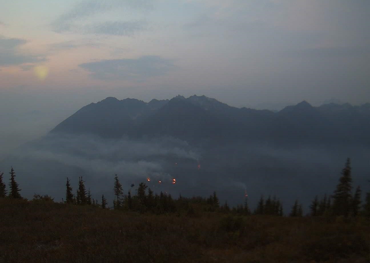
Miners Complex Daily Update 09 09 2024
Related Incident: Miners Complex Fires
Publication Type: Announcement
3:00 PM, September 6, 2024
Estimated size: 1,098 acres
Start Date/Time: July 17, 2024
Area of Origin: 21 air miles east of Darrington WA
Cause: Lightning
Fuels/Topography: timber, rugged terrain
Structures Damaged: None, there are no homes threatened at this time.
Evacuations: None
The Miners Complex consists of eight wildfires caused by lightning strikes in the Mt. Baker-Snoqualmie National Forest. The fires included in the complex are Miners Fire, Vista Ridge Fire, Dolly Creek Fire, Sulphur Three Fire, Sulphur Four Fire, Sulphur Thirty-Four Fire, Plummer, and Middle Ridge Fire.
Update: Increased fire activity occurred Thursday through Saturday as expected, but without significant fire growth. Activity tapered off on Sunday due to haze and smoke sitting in the Suiattle valley. Cooler temperatures will provide relief over the next few days. Firefighter crews continue patrols of the Miners Complex along with accompanying rehab work.
Weather: Marine stratus clouds have made it throughout Puget Sound and into the Cascades. Expect them to linger in the fire area through early this afternoon, around 1 to 2 PM. Winds today will be out of the southwest, but will switch to a northwesterly after 4PM local time today. Low pressure offshore will contribute to a cooler next few days, continued mornings with marine stratus clouds and excellent relative humidity recoveries. They next chance of rain will be Tuesday night into Wednesday as the next frontal system moves in. The high temperature will be around 68°F, with 5-6mph winds becoming west in the afternoon.
Smoke: For more information on smoke and air quality please visit: https://wasmoke.blogspot.com/
Closures: The following is a summary of the areas closed due to the fires in the Miners Complex: Pacific Crest National Scenic Trail #2000.2 from Mica Lake to Suiattle Pass, Suiattle River Trail #784, Miners Ridge Trail #785, Buck Creek Pass Trail #789, Miners Cabin Trail #795, Grassy Point Trail #788, Sulphur Mountain Trail #794, Sulphur Creek Trail #793, Sulphur Creek Campground, Sulphur Creek Trailhead, and the Downey Creek trailhead. Suiattle River Road, closure beginning at Downey Creek trailhead. The full Closure Orders visit: https://www.fs.usda.gov/mbs Forest Restrictions: The Mt. Baker-Snoqualmie has lifted the full campfire ban and forest-wide shooting restrictions, effective 8/28/2024. Additional details at: www.fs.usda.gov/mbs
###
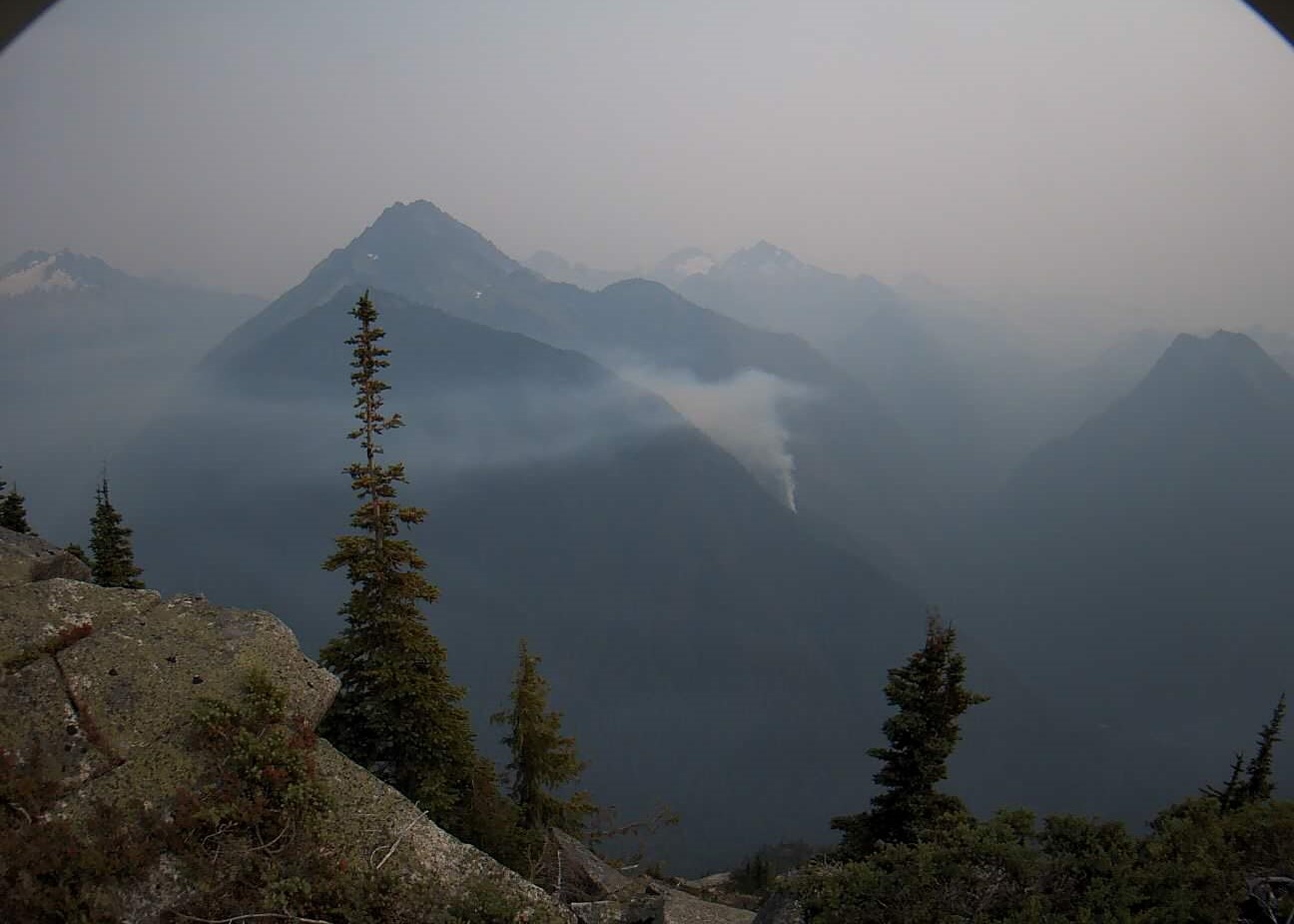
Pincer Two Fire Daily Update 09 09 2024
Related Incident: Pincer Two Fire
Publication Type: Announcement
3:00 PM, September 9, 2024
Estimated size: 211 acres
Start Date/Time: July 17, 2024
Area of Origin: Johannesburg Mountain. 1 Mile East of Mineral Park C.G.
Cause: Lightning
Fuels/Topography: Timber, rugged terrain
Structures Damaged: None, there are no homes threatened at this time.
Evacuations: None
Closures: Cascade River Road at and including Marble Creek Campground, Mineral Park Campground, and all tributary roads, trailheads, and trails are all closed. The public is not to enter the area for public and firefighter safety.
Full closure orders available at: https://www.fs.usda.gov/mbs
Update: Hot and dry temperatures on Thursday and Friday of last week led to increased fire activity as anticipated, and the fire continues to be active on the southeast portion of the fire. Slightly cooler temperatures and haze provided some relief on Saturday and Sunday. The fire is slowly backing down the slope to the 1590 Road. Firefighters will continue to track any rolling debris and hot spots and monitor fire behavior, and cooler temperatures will provide relief over the next few days.
Weather: Marine stratus clouds have made it throughout Puget Sound and into the Cascades. Expect them to linger in the fire area through early this afternoon, around 1 to 2 PM. Winds today will be out of the southwest, but will switch to a northwesterly after 4PM local time today. Low pressure offshore will contribute to a cooler next few days, continued mornings with marine stratus clouds and excellent relative humidity recoveries. They next chance of rain will be Tuesday night into Wednesday as the next frontal system moves in. The high temperature will be around 68°F, with 5-6mph winds becoming west in the afternoon.
Smoke: For more information on smoke and air quality please visit: https://wasmoke.blogspot.com/
Air Space Restrictions: There are no air space restrictions at this time.
Forest Restrictions: The Mt. Baker-Snoqualmie has lifted the full campfire ban and forest-wide shooting restrictions, effective 8/28/2024. Additional details at: www.fs.usda.gov/mbs
###