
Incident Publication
McDermott Fire Update 09 09 2024
Related Incident: McDermott
Publication Type: News
Incident Commander: David McPhee
Location: 16 miles northwest of Philipsburg, MT
Start Date: 8/26/2024
Cause: Undetermined
Size: 319 acres
Resources on Site: 2 crews; 2 engines; 1 helicopter; miscellaneous heavy equipment
Total Personnel: 59
The McDermott Fire, located in the Upper Willow Creek area, is burning in an inaccessible area containing a large concentration of standing dead trees (“snags”) that pose challenges to ensuring firefighter safety and in responding to potential medical emergencies.
Fire managers from the Forest, working in collaboration with local county officials and cooperating agency representatives, have identified and prioritized critical values at risk in the fire area. The closest values are located three miles to the east of the fire’s location.
Helicopters dropped water on the fire during the initial attack phase, but high winds and the inaccessibility of the fire location resulted in fire growth. Additionally, drift smoke from other large fires to the west and south resulted in the inability to fly additional helicopters for air operations in subsequent days.
CURRENT STATUS/PLANNED ACTIONS:
This incident is being managed by Type 3 Incident Management Team.
The McDermott fire most active on the east and west flanks of the fire. Firefighters are continuing with suppression efforts on the eastern flank of the fire to minimize fire growth towards private property. Aviation support will be limited today based on forecasted winds and low visibility due to hazy conditions.
The widespread haze moved in last night, primarily coming from the southwest. Fires in southern Idaho as well as eastern Oregon have been producing a majority of the smoke.
WEATHER AND FIRE BEHAVIOR:
Today, hot and dry conditions will persist, in addition to wind gusts up to 25 mph. There will be an increase in southwest winds through Tuesday. Temperatures will be in the mid-70s today with relative humidities in the mid-20s. Wednesday a cold front will move through the area, bringing moisture on Thursday. The fire could receive as much as 1 inch of rain.
Fire progression within the last operational period has been on the east and west flanks of the fire. With the increase of gusty winds, fire behavior may increase again today.
CLOSURES AND RESTRICTIONS:
The Forest is in Stage 1 Fire Restrictions. Campfires are allowed only in a permanent metal fire grate/ring provided by the Forest Service in a designated, developed recreation site. Smoking is restricted to vehicles, in buildings, or in an area clear of flammable materials. Devices with an on/off switch that use LPG fuels are allowed in an area clear of flammable materials within 3 feet of the device.
Forest fire managers have closed trails in the area near the fire for public safety.
These trails include the following:
Black Pine Ridge Trail #8006
McDermott Gulch Trail # 8238
Pole Ridge Trail # 8237
Horsetheif Trail # 8297
Schilo Creek Trail # 8240
Upper Will Trail #8106
Rattling Gulch Trail
The public is encouraged to refrain from entering these areas for their safety and to allow for safe and effective
firefighting operations. Heavy equipment, helicopters, and firefighters will be operating near the eastern flank of
the fire and adjacent areas.
Huckleberry Ridge Fire Update 09 09 2024
Related Incident:
Publication Type: News
Huckleberry Ridge Fire
Daily Update
September 9, 2024
Reported: September 4th at 3:45 p.m. | Size: 293 acres | Cause: Under investigation
Total Personnel: 322| Engines/Tenders:28 | Hand Crews: 11
The Huckleberry Ridge Fire continues to burn eight miles from the nearest structure and eleven miles from the nearest community. No infrastructure is at risk at this time.
Update: Crews worked overnight with some slight growth on the east side of the East Fork Chehalis River. Heavy logging slash, thick timber, and very steep terrain continue to challenge operations. However, crews have a great rhythm continuing to add more handlines and dozer lines around the fire perimeter and are transitioning to mop-up operations once solid control points are established. Another hand crew arrived this morning to assist with the good work the team is already doing. Crews will begin laying fire hose along the fire edge to help with cooling the interior edge of the fire as well as any hotspots or stumps still burning. Crews are also working along the 3000-line removing falling debris to help keep the road open for fire traffic use.
Safety: Hunting season continues so please be aware there are both firefighters and hunters in the woods right now. Use caution and stay vigilant. For anyone hunting, please stay out of the fire area and be aware there is substantial firefighting activity in the area with a lot of vehicle traffic.
Evacuations/Closures: There are no anticipated evacuations or road closures in the future for this fire, but we continue to ask that the community stay out of the area of the fire, be alert, and stay aware of the danger that exists in your area.
Weather: Today we are looking at a cloudy high of 72 degrees with some sunshine possibly peeking through. Winds are west-northwest at 5-10 mph. Tonight we are expecting a few clouds with lows of 51 degrees and light variable winds.
Air Space Restrictions: We continue to have a Temporary Flight Restriction (TFR) is in place over the fire. If you fly, we can’t.
Long Tom Fire 09 09 2024
Related Incident:
Publication Type: News
Location: Mount Haggin Wildlife Management Area, 20 miles southwest of Butte, Montana
Start Date: 9/08/2024
Cause: Suspected Lightning; Size: 110 acres
Containment: 0%
Gila County Sheriffs Office Issues SET Status for Geronimo Estates 09 09 2024
Related Incident: 2024 - West Fire - TNF
Publication Type: Announcement
As a result of fire-fighting activity on the West Fire, the Gila County Sheriff's has issued a "SET" status on the Ready, Set, Go model for the following areas due to anticipated fire activity.
- Geronimo Estates
Fire crews will begin fire operations on Monday, September 9th which will be conducted from the top of the Rim down Bray Creek to the Junction of the Control Road (FS64). They will then work west along Control Road toward Hwy 87 over the next few days.
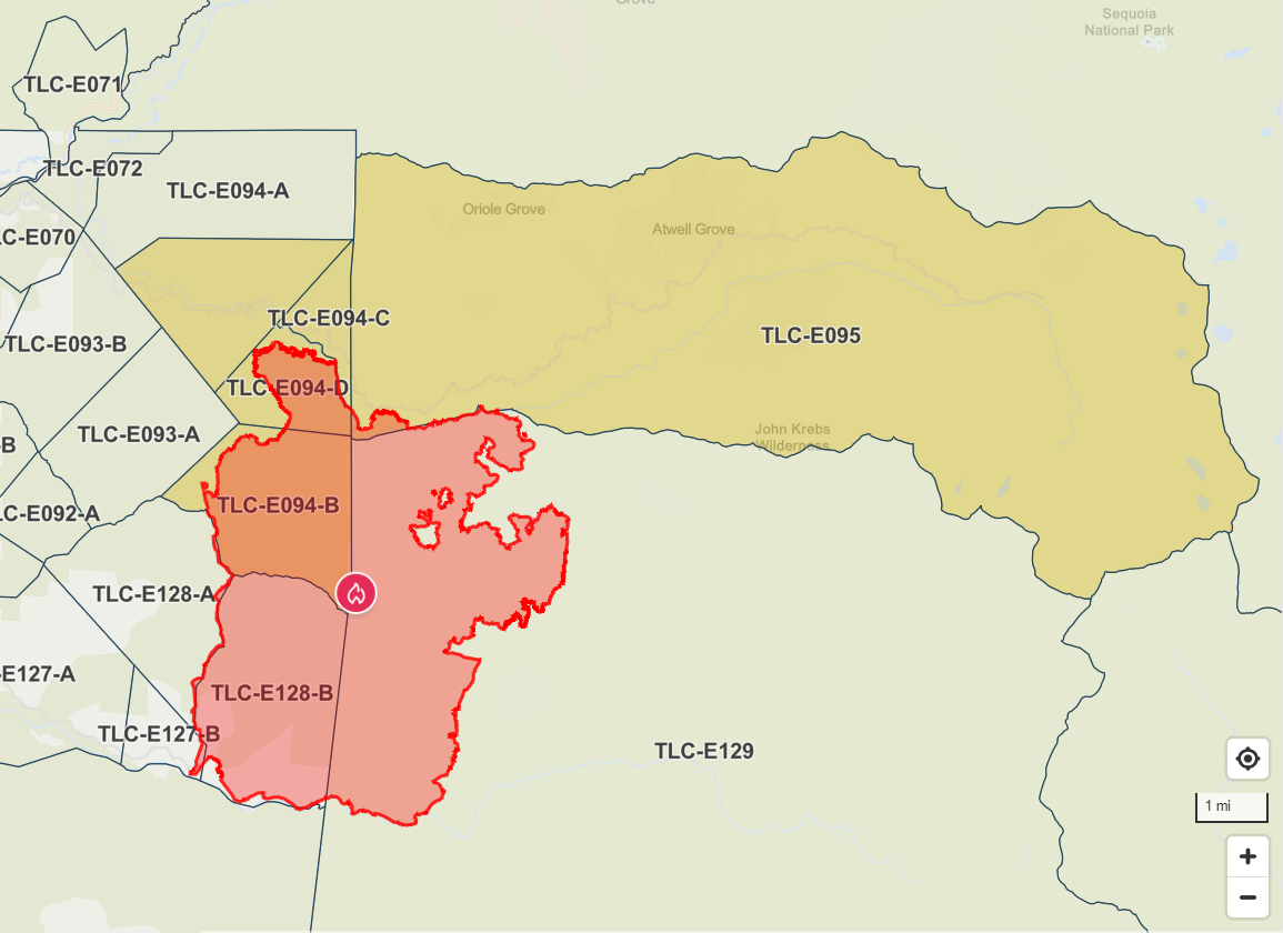
Coffee Pot Fire Evacuation Update 09 09 2024
Related Incident: Coffee Pot Fire
Publication Type: Announcement
Sheriff Lifts Evacuation Warnings, Reduces Orders Due to Coffee Pot Fire
Sheriff Boudreaux has announced the evacuation warnings for the following areas TLC-E128-A, TLC-E093-A and TLC-E093-B, have been LIFTED. The area includes North of South Fork Drive, West of East Fork Kaweah River, East of Salt Creek Road and South of Craig Ranch Road.
Evacuation ORDERS have been reduced to WARNINGS for the following areas: TLC-E094-B, TLC-E094-C, TLC-E094-D and TLC-E094-E. The area includes Case Mountain area, just north of Mineral King Road, East of Oak Grove and West of the Park Boundary line.
Due to fire conditions in the area, there will be road closures along Mineral King Road, between Oak Grove and the National Park Boundary.
For public safety reasons, the access through Mineral King Road may be limited by fire activity, and there may be significant time delays. This will be in effect until further notice and can change at any time.
Please refer to the Genesys website for a more detailed area description: protect.genasys.com.
Residents may now be in this area. However, please be mindful when you are traveling, Fire crews may still be in the area. Please stay clear and out of the areas affected by the fire.
For additional information, please call the Incident Public Information office at 559-492-9988 or refer to https://ow.ly/qmbB50TjjtU.
Sept 9 2024 Middle Fork Complex radio interview 09 09 2024
Related Incident:
Publication Type: Announcement
Here is today's radio interview with KXGV
KXGV Uncle Doug radio interview for the Middle Fork Complex on Sept 9, 2024 (youtube.com)
Willamette Complex North Daily Update 09 09 2024
Related Incident: North Willamette Complex
Publication Type: News
Willamette Complex North Daily Update
2024.WillametteComplex.North@firenet.gov
Information line: 541-208-1262, 8 am to 8 pm
Facebook: https://facebook.com/OreFireInformation2024;; https://www.facebook.com/PyramidFireInfo2024/
Monday, September 9, 2024 Message: California Incident Management Team 13 assumed command of three new fires. In addition to the Pyramid, Ore and Linton Creek, the IMT also has the Boulder, Round Top, and the “374” fire within the Willamette Complex North. Resources remain identified and available to respond for initial attack fires if needed.
Suppression Objectives: The Boulder Creek, Ore, Linton Creek, Pyramid, 374, and Roundtop Fires are full suppression fires. Many different strategies used to protect values at risk, including infrastructure, communities, and Highway 126, the Middle Santiam Wilderness, HJ Andrews Experimental Forest, and private timberlands are being implemented. Firefighters are building direct fire line where possible, and strategic indirect contingency line as needed. In addition, heavy equipment, fire retardant, and water dropping air support are being used.
Current Situation: Many fires are currently burning on the Willamette National Forest. If more fires come under the command of Team 13, fires will be prioritized for values at risk to life and property.
Boulder Fire: 5 Miles West of McKenzie Bridge, acres, 0% contained, lightning caused. Firefighters are shifting resources to the Boulder fire. Fire personnel will be coming in and out Highway 126 to access key locations to engage the fire. Please be advised of fire traffic. A Level 1 (Be Ready) evacuation notice is in effect for North of Highway 126 East from the east end of Drury Land to Old Clear Lake Cutoff Loop. View an Interactive Evacuation Status Map.
Ore Fire: 7 miles Northeast of Blue River, 3,397 acres, 43% contained, human caused. Firefighters are continuing with cleaning up the 1509 road to secure and clean up below the Ore Creek drainage. Material from activity fuels will be hauled away to improve and secure fire lines.
Linton Creek: 621 acres, 0% contained, lightning caused. Firefighters scouted access points and are gathering intelligence on areas to engage the fire. This is being managed under a full suppression strategy.
Pyramid Fire: East of Middle Santiam Wilderness, 1,312 Acres, 98% contained, lightning caused. Work will continue with masticating and chipping on contingency lines. Material created from this work will be hauled away.
Safety: check Lane County and Deschutes County for evacuation orders within the Willamette Complex North.
Closures & Fire Restrictions: Willamette National Forest - Alerts & Closures (usda.gov)
Everyone is reminded to stay out of all fire closures for firefighter and general safety. Violations of these prohibitions are punishable by a fine of up to $5,000. All campfires, charcoal fires, pellet fires, or any other open fires are prohibited, including in developed campgrounds and wilderness areas. Pressurized liquid or gas stoves, lanterns, and heaters that can be switched on and off are allowed. Please see Forest Order 06-18-00-24-27 for additional information.
Beginning at noon on Monday, travelers near McKenzie Pass can expect traffic control changes to support fire operations. Highway 242 will be closed to all traffic at the intersection with Highway 126 (mileposts 55 to 77). Crews will remain in the area to assist with evacuations. Highway 126 between mileposts 15 and 17 will be reduced to one lane with pilot cars guiding traffic. Do not divert onto forest roads to avoid closures, check TripCheck for updates.
Fire Crews of the Commonwealth of the Northern Mariana Islands Saipan Assist With Fire Suppression Efforts 09 09 2024
Related Incident: Park Fire
Publication Type: Announcement
Click the link to view a video of Justin Mizutani explaining the program that utilizes fire crews of the Commonwealth of the Northern Mariana Islands (Saipan) and how they are filling a request from California to assist with fires in the region and on the Park Fire.
Lassen National Forest Eagle Lake District Ranger Bobette Jones Speaks to Transitioning from FIre Suppression to Suppression Repair 09 09 2024
Related Incident: Park Fire
Publication Type: Announcement
Click Lind to a video from Lassen National Forest, Eagle Lake District Ranger Bobette Jones Speaking to Transitioning from Fire Suppression to Suppression Repair.
Fossil Complex Morning Update 09 09 2024
Related Incident: Fossil Complex
Publication Type: News
EMBER SHOWERS START SPOT FIRES ACROSS ORE 19 OVERNIGHT ON THE FOSSIL COMPLEX
SPRAY, Ore. – High temperatures and dry fuel conditions led to aggressive fire behavior yesterday which challenged firefighters. Ground fuels burning and trees torching inside the fireline created ember showers which shifting winds carried across ORE 19. A spot fire started in the vicinity of Pioneer Park and crews worked through the night lining, plumbing and holding it at 21 acres. Local structural fire crews assisted fire resources through the afternoon and evening to secure structures near the fire.
Today’s priorities are to continue building and strengthening line, extinguishing spot fires, securing structures and minimizing the spread of the Service fire. Aerial resources and ground crews will continue coordinated efforts as conditions permit. Please avoid the unauthorized use of drones. They are hazardous to aircraft and will ground critical aerial operations.
The Two Cabin and Holmes Fires are now in patrol status. Mop up continues on the Kinzua and Canyon Fires as crews work to strengthen the fire lines. As the need for resources on these fires diminishes, they will be shifted to the Service Fire and any other critical areas on the Fossil Complex.
Cooler temperatures are expected today with highs in the 80’s and humidity of 18-22%. A low-level inversion is expected to lift in the early afternoon which will increase the potential for extreme fire behavior. Firefighters are expecting ridgetop winds of 6-10 mph with gusts to 12 mph along west facing slopes. Looking ahead, Mary Wister, Incident Meteorologist says, “Wednesday’s weather will be a game changer, with Fall-like conditions.” Cooler temperatures and wetting rains are in the forecast.
Evacuations: Level 1, Level 2 and Level 3 evacuation orders remain in place on the Service fire.
https://www.facebook.com/WheelerCountySheriffsOffice/
FIRE AT A GLANCE
Fossil Complex
Total Size: 7,526 acres
Two Cabin-251acres
Canyon-190 acres
Kinzua-96 acres
Holmes-15 acres
Service- 6,974
Containment: 3%
Cause: Lightning
Current Cost: 2.6M
All Resources
Hand Crews: 35
Engines: 31
Water Tender: 8
Dozers: 18
Skidders: 5
Skidgen: 3
Excavator: 2
Feller Buncher: 1
Total Resources: 969
Aerial Resources
Type 1: 1
Type 2: 2
Type 3: 3
Evacuations: https://www.facebook.com/WheelerCountySheriffsOffice/
Level 1: 14 addresses
Level 2: 15 addresses
Level 3: 20 addresses
ODF Incident Commander:
Matt Howard
Incident Management Team 2