
Incident Publication
US Forest Service Closure Order for West Fire 09 04 2024
Related Incident: 2024 - West Fire - TNF2024 - Preacher Fire - TNF
Publication Type: Closures
West Fire Emergency Closure Order
PROHIBITIONS
Pursuant to 16 U.S.C. § 551 and 36 C.F.R. § 261.50 (a) and (b), the following is prohibited on the National Forest System (NFS) area, roads and trails in the Payson and Mogollon Ranger Districts, Tonto and Coconino National Forests, described below and shown on the attached map incorporated into this Order as Exhibit A (the
Described Area:
- Going into or being upon the Described Area. 36 C.F.R. § 261.53(e)
- Being on any road within the Described Area. 36 C.F.R. § 261.54(e)
- Being on any trail within the Described Area. 36 C.F.R. § 261.55(a)
EXEMPTIONS
Pursuant to 36 C.F.R. § 261.50(e), the following persons are exempt from this Order:
- Persons with Forest Service Permit No. FS-7700-48 (Permit for Use of Roads, Trails, or Areas Restricted by Regulation or Order), specifically exempting them from this Order or a written determination by a Forest Service authorized officer that a permit is not required under 36 C.F.R. § 251.50(e)(1) or (2).
- Any Federal, State, or Local Officer, or member of an organized rescue or firefighting force in the performance of an official duty.
- Arizona Dept. of Fire and Forestry Management contractor Suarez Forestry and Canyon Creek Logging to operate on and around Forest Road 64.
- Residents of Camp Geronimo, Geronimo Estates and Bray Creek Ranch being on Forest Service Road 64.
DESCRIBED AREA, ROADS, and TRAILS
The Described Area consists of all National Forest System lands, roads, and trails within the Boundary starting at the intersection of State Route (SR) 87 and National Forest System Road (NFSR) 64 (Control Road), then following northwest along the northeast side of SR-87 approximately 1.75 miles to the intersection with the Non- Forest Service Ownership (Community of Pine), then following east and north around the Non-National Forest System lands approximately 3.35 miles to the intersection with Trail 26 Pine Canyon, then following northeast along the northwest side of Trail 26 Pine Canyon approximately 3.5 miles to the intersection with NFSR 6038, then following north along the west side of NFSR 6038 approximately 0.1 miles to the intersection with SR-87, then following east along the south side of SR-87 approximately 1.5 miles to the intersection with NFSR 300, then following south along the west side of NFSR 300 approximately 0.1 miles to the intersection with NFSR 218A, then following south along the east side of NFSR 218A approximately 1.35 miles to the intersection with NFSR 218, then following east along the north side of NFSR 218 approximately 3 miles to the intersection with NFSR 300, then following southeast and northeast along the southwest and southeast side of NFSR 300 approximately 4 miles to the intersection with Chase Creek, then following southeast along Chase Creek approximately 1.5 miles to the intersection with Motorized Trail (MT) 646, then following south along the east side of MT-646 approximately 2 miles to the intersection with NFSR 32, then following southwest along the northwest side of NFSR 32 approximately 1 mile to the intersection with NFSR 64, then following west along the south side of NFSR 64 approximately 9.25 miles back to the point of beginning at the intersection of NFSR 64 and SR-87.
Routes along and within the Described Area boundary that are closed include: Trail 26 Pine Canyon, NFSR 6038, NFSR 218A, NFSR 218, MT-646, NFSR 64. Boundary
Routes SR-87, NFSR 300, and NFSR 32 remain open. Pine Trailhead, Red Rock Trailhead, and Geronimo Trailhead are also closed.
PURPOSE
The purpose of this Order is to protect public health and safety due to firefighting operations and fire danger associated with the uncontrolled West Fire on the Tonto and Coconino National Forests.
IMPLEMENTATION
- This Order shall be in effect from September 4, 2024, at 12:00pm through October 31, 2024, at 06:00pm, unless rescinded.
- A map identifying the Described Area, Roads, and Trails is attached and made part of this Order as Exhibit A. For a digital version of this Order and Exhibit A, go to https://www.fs.usda.gov/alerts/tonto/alerts-notices
- Unless otherwise expressly defined in this Order, the terms used in this Order are defined by the regulations of the Secretary of Agriculture, 36 C.F.R. Chapter II,
Parts 200-299. If there are terms in this Order that are not expressly defined in the Order or 36 C.F.R. Chapter II, Parts 200-299, their meaning shall be determined by their plain language definitions.
- A violation of the above prohibitions is punishable as a Class B misdemeanor by a fine of not more than $5,000 for individuals and $10,000 for organizations, or by imprisonment for not more than six months, or both. 16 U.S.C. § 551; 18 U.S.C.
§§ 3559, 3571, and 3581.
- Contact the Payson Ranger District in Payson, AZ, (928) 474-7900, and Tonto National Forest Supervisors Office in Phoenix, AZ, (602) 225-5200, or the Mogollon Ranger District in Happy Jack, AZ, (928) 477-2255, and Coconino National Forest Supervisors Office in Flagstaff, AZ, (928) 527-3600 for more information about this Order.
- This Order supersedes any previous Orders prohibiting the same or similar acts on the same Described Roads, Trails, and Area.
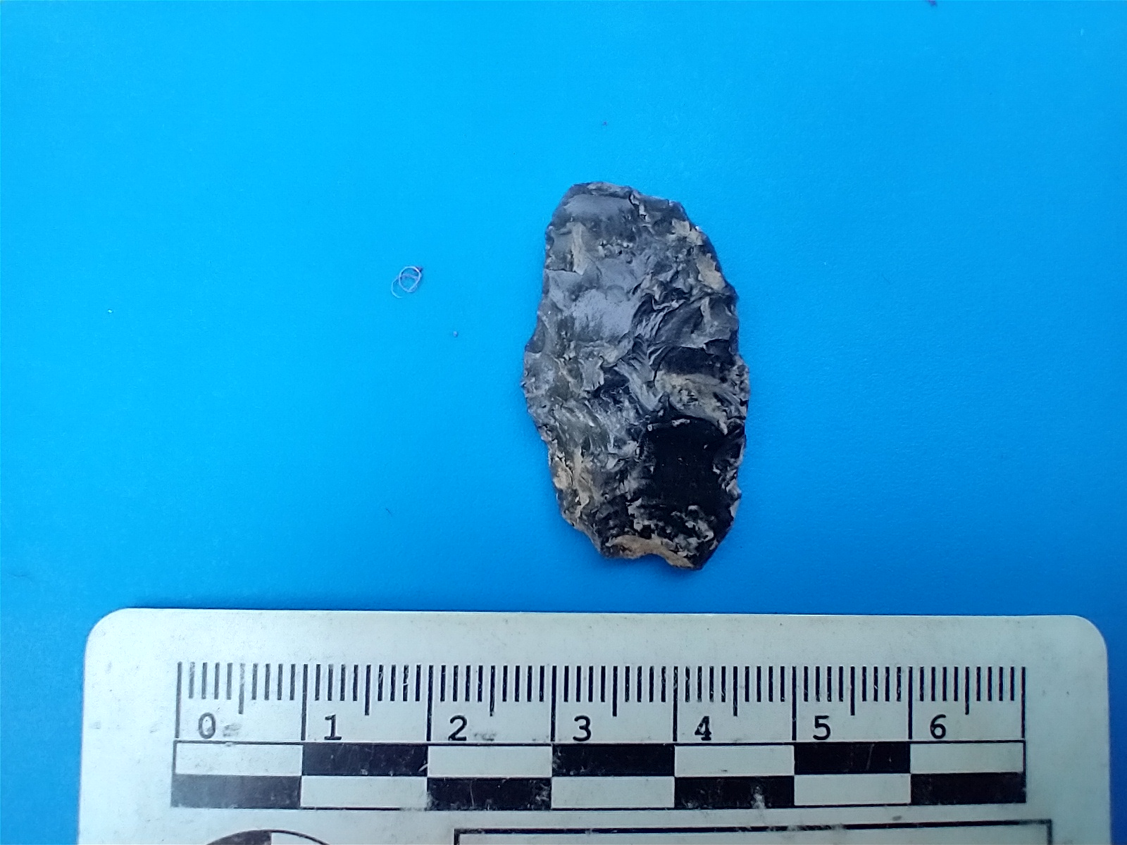
Archaeological Tool found on the Ore Fire 09 04 2024
Related Incident: North Willamette Complex
Publication Type: Announcement
These are the photos of a tool found on the Ore fire. Nate, Division W/ Z from PNW team 7 was a para-archaeologist in his previous job.
He noticed some glinting in the middle of a road that had been scraped during fire operations and called the archaeology Resource Advisors (REAFs) to investigate. They found this tool along with numerous other indicators of prehistoric human activity. Little remains of the site in the middle of the road, but any other sites in the area can now be recorded and protected from further actions. What a great collaboration between Ops and REAFs to protect our cultural resources.
Just a note that collecting archaeological artifacts on public land is a federal offense, so please leave them where they lie. (CFR 261.9(h) fine up to $500 or mandatory appearance in federal court)
West Preacher Fire Update 09 04 2024
Related Incident: 2024 - West Fire - TNF2024 - Preacher Fire - TNF
Publication Type: News
Southwest Complex Incident Management Team 3 Assumes Command of the West & Preacher Fire
Highlights: The Southwest Complex Incident Management Team 3 assumed command of the West and Preacher Fires at 6 a.m. this morning.
Operations:
West Fire -24 Acres: Yesterday afternoon, the West Fire creeped over on to the top of the Mogollon Rim. Fire behavior was active but low intensity. Today, firefighters will continue to evaluate and improve firelines with a focus on the protection of values at risk (VAR). Handcrews, masticators, and dozers are being utilized to strengthen firelines. Values at risk include the private lands and the communities of Camp Geronimo, Geronimo Estates, Bray Creek Ranch and Pine. Infrastructure values at risk include powerlines, Coconino Forest Service Road (FSR) 300, Coconino FSR 218, State Route 87 and Tonto FSR 64. Natural and cultural resource VARs include range infrastructure, wildlife habitat, cultural resources, timber, and recreation areas.
Preacher Fire - 2 Acre: The Preacher Fire is burning about 8 miles northeast of Payson, Arizona. Today, firefighters will be masticating and snagging off the 218 road corridor to improve firelines.
Weather: Today, sunny with a high of 91 degrees and a low of 62. Winds will be light and variable becoming southwest 5-8 mph.
Safety: The health and safety of firefighters and the public are always the first priority. Members of the public are asked to avoid the fire area while fire operations are being conducted.
Smoke: Smoke from the West Fire may be visible in the surrounding areas for many days. Smoke will be heavier in the mornings as it settles into the lower elevations and will lift as temperatures increase. As temperatures increase the volume of smoke may increase due to the drying and ignition of available fuels. Smoke-sensitive individuals and people with respiratory problems or heart disease are encouraged to take precautionary measures. Learn more about smoke impacts on the Arizona Department of Environmental Quality website.
The West Fire is a lightning-caused wildfire that is currently burning four miles northeast of Pine, Arizona. The fire is being managed under a confine/contain strategy with the goal of reintroducing fire into a fire dependent ecosystem. The intended result of managing naturally caused fires are to reduce hazardous fuels, encourage the growth of native forage, improve range conditions, increase species diversity, protect and improve wildlife habitat, improve watershed conditions and restore ecological balance. This will decrease unnaturally high accumulations of fuels and the potential for future fires to burn with unnaturally high severity, aligning with the Forest Service Wildfire Crisis Strategy.
For the latest news and information about the Tonto National Forest, follow along on Facebook @TontoNationalForest, ‘X’ (formerly Twitter) @TontoForest or Instagram @tontonationalforest and on the Tonto National Forest website.
Miners Complex Daily Update 09 04 2024
Related Incident: Miners Complex Fires
Publication Type: Announcement
11:00 AM, September 4, 2024
Estimated size: 1,098 acres
Start Date/Time: July 17, 2024
Area of Origin: 21 air miles east of Darrington WA
Cause: Lightning
Fuels/Topography: timber, rugged terrain
Structures Damaged: None, there are no homes threatened at this time.
Evacuations: None
The Miners Complex consists of eight wildfires caused by lightning strikes in the Mt. Baker-Snoqualmie National Forest. The fires included in the complex are Miners Fire, Vista Ridge Fire, Dolly Creek Fire, Sulphur Three Fire, Sulphur Four Fire, Sulphur Thirty-Four Fire, Plummer, and Middle Ridge Fire.
Update: The planned reconnaissance flight for Wednesday, September 4th was cancelled, and fire managers are looking to reschedule as soon as possible, so firefighters can assess fire behavior and any growth during this warm weather trend. The Sulphur fires continue to put up visible smoke, and smoke is expected to continue with hot and dry weather over the next few days. Firefighter crews continue patrols of the Miners Complex along with accompanying rehab work.
Weather: Dry conditions and warming temperatures are expected for the rest of the week. Instability from a thermal pressure trough will result in mid-level Haines 6 values while east to southeast winds throughout the period will not only aid in drying but also hinder RH recoveries. While conditions will approach critical fire weather thresholds today, the main concern will be Thursday and Friday. Thursday especially will be ripe for fire growth with the combination of the strongest easterly winds in the morning along with dry and unstable conditions throughout the day. High temperature around 85°F, with east winds between 5-8 mph.
Smoke: For more information on smoke and air quality please visit: https://wasmoke.blogspot.com/
Closures: The following is a summary of the areas closed due to the fires in the Miners Complex: Pacific Crest National Scenic Trail #2000.2 from Mica Lake to Suiattle Pass, Suiattle River Trail #784, Miners Ridge Trail #785, Buck Creek Pass Trail #789, Miners Cabin Trail #795, Grassy Point Trail #788, Sulphur Mountain Trail #794, Sulphur Creek Trail #793, Sulphur Creek Campground, Sulphur Creek Trailhead, and the Downey Creek trailhead. Suiattle River Road, closure beginning at Downey Creek trailhead. The full Closure Orders visit: https://www.fs.usda.gov/mbs Forest Restrictions: The Mt. Baker-Snoqualmie has lifted the full campfire ban and forest-wide shooting restrictions, effective 8/28/2024. Additional details at: www.fs.usda.gov/mbs
###
Pincer Two Fire Daily Update 09 04 2024
Related Incident: Pincer Two Fire
Publication Type: Announcement
11:00 AM, September 4, 2024
Estimated size: 211 acres
Start Date/Time: July 17, 2024
Area of Origin: Johannesburg Mountain. 1 Mile East of Mineral Park C.G.
Cause: Lightning
Fuels/Topography: Timber, rugged terrain
Structures Damaged: None, there are no homes threatened at this time.
Evacuations: None
Closures: Cascade River Road at and including Marble Creek Campground, Mineral Park Campground, and all tributary roads, trailheads, and trails are all closed. The public is not to enter the area for public and firefighter safety.
Full closure orders available at: https://www.fs.usda.gov/mbs
Update: A reconnaissance flight occurred on Tuesday, September 3rd. The flight showed that the fire has remained inside its original footprint, and the visible smoke is likely coming from heavy fuels burning in the interior of the fire. High temperatures on Thursday show the greatest chance of predicted fire growth, and visible smoke is expected to continue with warm weather trends through Friday. Firefighters continue to track and patrol hotspots on the fire.
Weather: Dry conditions and warming temperatures are expected for the rest of the week. Instability from a thermal pressure trough will result in mid-level Haines 6 values while east to southeast winds throughout the period will not only aid in drying but also hinder RH recoveries. While conditions will approach critical fire weather thresholds today, the main concern will be Thursday and Friday. Thursday especially will be ripe for fire growth with the combination of the strongest easterly winds in the morning along with dry and unstable conditions throughout the day. High temperature around 85°F, with east winds between 5-8 mph.
Smoke: For more information on smoke and air quality please visit: https://wasmoke.blogspot.com/
Air Space Restrictions: There are no air space restrictions at this time.
Forest Restrictions: The Mt. Baker-Snoqualmie has lifted the full campfire ban and forest-wide shooting restrictions, effective 8/28/2024. Additional details at: www.fs.usda.gov/mbs
###
Homestead Complex Update 09 04 2024
Related Incident:
Publication Type: News
Homestead Complex Fire Update for Wednesday, September 4, 2024
Start Date: July 19, 2024 | Location: 15 miles Northeast of Glide | Total Number of Fires: 7 | Total Personnel: 553 | Total Fire Acreage: 5,918 | Cause: Lightning | Overall Complex Containment: 60%
Fire Operations Summary: The predicted hotter and drier weather the next few days may bring with it opportunities to conduct planned tactical burnout operations on the north flank of the Horse Heaven Fire. Firefighters have been strengthening control lines as part of a larger strategic plan that includes being ready to conduct firing operations. Burnout operations strengthen control lines by removing unburned fuel in a way that allows better control over the intensity of the fire which then reduces the risk of the fire crossing control lines. A successful burnout operation will most likely produce more visible smoke in the area than has been the case recently. The burnout operations are planned to start Thursday (tomorrow) and continue over multiple days this week. The source of smoke/haze that is visible today is from recent fire starts out of eastern Oregon.
Across the fire complex of seven fires, firefighters are working to complete and secure all remaining primary and secondary (contingency) control lines. This work includes using crews and heavy equipment to chip and haul away forest fuels near control lines. Patrol and mop-up operations continue, and suppression repair groups are working to minimize the fire impacts to resources, lands, and facilities resulting from firefighting operations. Firefighters are prepared to do initial attack on any new fire starts within the delegated fire operations area and to support local fire resources.
Three of the seven fires on the complex have now reached 100% containment, the Salmon 33 Fire (275 ac.) on August 24, 2024, the Reynolds Butte Fire (334 ac.) on August 22, 2024, and the Lost Bucket Fire (34 ac.) on July 29, 2024. On the No Man Fire (2,072 ac., containment: 28%), crews are patrolling and mopping-up. Chipping operations are continuing. On the Horse Heaven Creek Fire (2,304 ac., containment: 64%), crews will continue improving control lines in preparation for possible burnout operations. On the Bullpup (473 ac., containment: 17%) and Fuller Lake fires (426 ac., containment: 5%) work to reinforce control lines on the 300 and 200 roads is nearing completion. Suppression repair work will continue on the Reynolds Butte and Lost Bucket fires.
Weather: Hot and dry conditions can be expected. Temperatures will climb into the 90s. Winds will be light.
Closures and Fire Restrictions:
There is one large closure impacting the Cottage Grove, North Umpqua, and Diamond Lake districts. Emergency Fire Closure ORDER NO. 06-15-24-07: https://www.fs.usda.gov/alerts/umpqua/alerts-notices/?aid=88996. On August 30, 2024, the Umpqua National Forest decreased Public Use Restrictions (PURs) to Level 2, visit https://www.fs.usda.gov/detail/umpqua/news-events/?cid=FSEPRD1202470. For more information on PURs, IFPLs, or other fire management information, visit: https://www.fs.usda.gov/main/umpqua/fire
The closure order issued by Bureau of Land Management (BLM), Roseburg District, for portions of BLM land which border the Umpqua National Forest Emergency Fire Closure north of Steamboat remains in effect: https://www.blm.gov/sites/default/files/docs/2024-07/orwa-fpo-rbg-072624.pdf
There is a Temporary Flight Restriction (TFR) over the Homestead Complex Fire. Please remember, if you fly we can’t! If a drone or other aircraft enters the air space, all firefighting aviation equipment will be grounded.
Fire Information Line: 541-208-7100 (Staffed 8 a.m. to 8 p.m.)
Email: 2024.homesteadcomplex@firenet.gov Smoke Outlook: https://outlooks.airfire.org/outlook/d393fd74
Facebook: https://www.facebook.com/HomesteadComplexFireInfo/
Inciweb: https://inciweb.wildfire.gov/incident-information/orupf-homestead-complex
We are Protecting Wilderness on the 60th Anniversary of the Wilderness Act 09 04 2024
Related Incident: North Willamette Complex
Publication Type: Announcement

A wilderness, in contrast with those areas where man and his own works dominate the landscape, is hereby recognized as an area where the earth and its community of life are untrammeled by man, where man himself is a visitor who does not remain.”
Those words may sound poetic, but in fact, they come from a legal statute. Today is the 60th anniversary of the passage of that law, the Wilderness Act. This law, which enabled the creation of all of the federally designated wildernesses in the United States was not easy to pass. While many Americans in the 1960s were worried about the rapid loss of America’s wildest places, wilderness advocates, business interests, land managers, and lawmakers had wildly varying opinions about how wildernesses should be created, their relative importance, and how they should be managed and created.
Members of congress created 60 different, varying drafts of a Wilderness Act over 8 years of effort before the Wilderness Act was passed. Its passage was a direct result of the tireless advocacy of Idaho Senator Frank Church, who grew up hiking, fishing, and riding horses in Idaho’s wild spaces. Church brought together wilderness proponents and opponents in listening sessions where they got to know each other and their concerns about the act’s policies. Church’s work led these often bitterly opposed groups to see the merits of each other’s arguments, slowly building the consensus that enabled the act to pass. Today, Frank Church has a large wilderness in Idaho named after him. Designated in 1980, the Frank Church – River of No Return Wilderness is over 2 million acres.
Right now, firefighters on the Pyramid Fire are working to protect the Middle Santiam Wilderness Area in the Willamette National Forest from catastrophic wildfire. The wilderness area is closed to public access as they work to protect it. Though its 8,900 acres are smaller than most wilderness areas, it is still a wild and beautiful place. Designated in 1984 to preserve a pristine old growth forest of western red cedars, western hemlocks, and Douglas fir, some of which are 450 years old and over 200 feet tall, it is an excellent place to find solitude. Fishermen and wildlife lovers are attracted to this special place for its abundant fisheries and the chance to see bear and elk. If you are interested in seeing beautiful blue waters surrounded by towering, ancient trees, the Middle Santiam Wilderness is the place for you.
Today, on the anniversary of the Wilderness Act, we wanted to give you a sense of why wilderness matters and why the firefighters on our team are working to protect this special place. While fire management has recognized for several decades the important role of fire in wilderness landscapes, the Middle Santiam Wilderness is a tiny remnant of what we once had in the coastal Northwest. Protecting this landscape not only allows you to see what the Northwest looked like in the past, it gives scientists a chance to study and learn how to regenerate these landscapes and provides refuge for species driven from other areas by deforestation. We hope you will visit it when it is safe to access, but for now, we hope you enjoyed this virtual field trip
Willamette Complex South Daily Update for Wednesday 09 04 2024
Related Incident: Willamette Complex Fires - South
Publication Type: News
![]()
![]()
Willamette Complex South Update
Chalk, Coffeepot, McKinley, Moss Mountain, Tire Mountain, 208, and 217 Fires
Online: https://inciweb.wildfire.gov/incident-information/orwif-willamette-complex- fires-south
Facebook: https://www.facebook.com/WillametteComplexFires/
Email: 2024.willamettecomplex@firenet.gov Information Line: 541-208-1742
Wednesday, September 4, 2024 Fire Cause: Lightning
Total Willamette Complex South Personnel: 659
Total Willamette Complex South Acres: 13,644
Resources (Includes Pyramid Fire Resources): 2 Type 1 Hotshot crews, 8 Type 2 crews, 3 Type 2 initial attack crews, 3 helicopters, 23 engines, 6 dozers, 155 heavy equipment (masticators, skid steers, feller bunchers, etc.)
Summary
Heavy fuels retain heat and may serve as ignition sources as drying conditions continue. Low to moderate fire
behavior is likely and may include flare-ups and isolated torching as surface heat aligns with dry fuels. Interior areas within the four fires are primarily experiencing creeping, and smoldering fire characteristics. Residual heat sources are well interior of the containment features except in the 208 fire which continues to experience intense heat in the
south and southwest edges of the fire.
Chalk Fire (5,788 acres, 66% containment)
Crews continue to secure fire edge as directly as possible to protect the communities of High Prairie, Westfir, and Oakridge to the south; the Highway 58 and Union Pacific Railroad corridors and west; the community of Lowell and private timber lands to the west; and infrastructure and cultural sites throughout the fire area.
Moss Mountain Fire (923 acres, 0% containment)
Keep the fire north of private timber lands in the Simpson Block by improving and holding forest road systems. Provide indirect tactics to confine northward spread. Protect Highway 58, Union Pacific Railroad corridors and Wolf Mountain Communications site to the north, and infrastructure and cultural sites throughout the area.
208 Fire (602 acres, 0% containment) Monitor fire activity. Implement indirect line construction outside the Diamond Peak Wilderness to protect Forest and private timberlands to the west.
217 Fire (38 acres, 100% contained) Monitor fire and ensure it remains fully contained.
Tire Mountain Fire (23 acres, 100% contained), McKinley Creek Fire (24 acres, 100% contained), Coffeepot Fire (6,182 acres, 100% contained)
These fires remain in monitor/patrol status. Mop-up continues on the Coffeepot Fire, as scattered hot spots remain. Helicopters may drop water on hot spots as necessary to keep these fires in check.
Weather and Fire Behavior
Very warm and dry conditions are expected to return to the area Wednesday and until the end of the week due to high pressure settles overhead. Temps will rise into the 80s and 90s and relative humidity will fall each afternoon into the teens. Winds will be light, but we still expect elevated fire behavior. Another storm system brings a chance for
storms Friday into Saturday.
Closures and Fire Restrictions
- For specific closure information, visit tinyurl.com/WillFireClosures2024
- For current fire restrictions, visit tinyurl.com/WillFireRestrictions2024
- Temporary Flight Restrictions (TFR): tfr.faa.gov for up-to-date areas. Wildfires are a no-fly zone for unauthorized aircraft, including drones. For more information, visit knowbeforeyoufly.org.
Shoe Fly Fire Morning Update 09 04 2024
Related Incident: Shoe Fly Fire
Publication Type: News
Limited fire growth, hot dry weather expected
MITCHELL, Ore. – After rapid fire growth Monday on the Shoe Fly Fire, firefighters saw reduced fire behavior and minor fire spread Tuesday. Overnight, firefighters worked to build fireline around small spotfires on the northeast side of the fire adjacent to the fire perimeter. The fire grew to 20,699 acres with 1% containment.
ODF Team 1 Incident Commander Joe Hessel thanked local landowners and partners at Wednesday morning’s briefing, stating, “A significant amount of great work was done prior to our arrival. This fire made a large push in its first 24 hours, but local fire agencies and landowners pushed back, and we’ll continue to build on their forward momentum.”
Coffee Pot Fire Daily Update 09 04 2024
Related Incident: Coffee Pot Fire
Publication Type: News
Unified Command: CAIIMT15 & CAL FIRE
Fire Size: 12,705 acres
Percent Contained: 25%
Primary Strategic Control Line: 94%
Personnel: 1,477
Cause: Lightning
Start Date: Saturday, August 3, 2024, at 10:05 a.m.
Location: Southeast of Three Rivers, CA
CURRENT SITUATION: Yesterday, firefighters prioritized operations on the fire’s northern flank.
Crews used strategic firing operations, direct control lines, water drops, and retardant to contain fire that
had reached beyond the primary control line near Case Mountain Road. As fire backed into the East Fork
Kaweah River yesterday, firefighters identified and suppressed spot fires that reached beyond the river’s
primary control line. On the northeast flank, crews worked to hold fire within the direct control line
toward Horse Creek, bolstering the line with fire retardant operations. To the south, firefighters monitored
for residual heat within the fire’s perimeter near Scratch Creek, with mop-up and repair activities
progressing along the South Fork Kaweah River containment line. Crews on the western flank patrolled
for any spot fires and held the containment line being established there.
Today, crews will again focus efforts on the northern flank. Firefighters will continue fortifying the
primary control line near Case Mountain Road. Crews will strengthen secondary indirect control lines
constructed along Mineral King Road. Firefighters will use low intensity back burning with aerial ignition
where fire has not yet reached the primary control line at the East Fork Kaweah River. Using aerial
resources, crews will add retardant along the ridges north of East Fork Kaweah River to bolster
containment efforts. On the northeast flank, firefighters will hold direct control lines southeast of the Eden
Creek Grove of giant sequoias, and will continue constructing control lines toward Horse Creek. To the
south, crews will monitor for any residual heat near Scratch Creek, and continue mop-up and repair along
the South Fork Drive containment line. Firefighters on the southwest flank will begin suppression repair
efforts. To the northwest, crews will monitor the area around Case Mountain for residual heat to ensure
control lines are holding.
WEATHER: Higher pressure will build over the region through mid-week bringing hotter temperatures and
drier conditions. Winds today and tomorrow will remain terrain-driven, upslope in the late morning through
the afternoon and overnight with drainage winds. Winds will remain from the southwest in the afternoon.
With higher pressure, the inversion will likely break later in the day than usual.
SMOKE IMPACTS: A slight change in the wind pattern will shift smoke back toward the north and west
today. This will improve conditions for communities on the east side of the Sierra but bring more smoke
from Springville up through Oakhurst, and possibly over to Mammoth. Areas from Three Rivers to the
Giant Forest, and the East Fork Kaweah drainage will likely see levels reaching UNHEALTHY to VERY
UNHEALTHY at times. For more information on current wildfire smoke impacts in your community,
please visit AirNow.gov or fire.airnow.gov.
EVACUATION NOTICES: The Tulare County Sheriff’s Office has issued Evacuation ORDERS due to current fire conditions for Genasys zones TLC-E094-C, TLC-E094-E, TLC-E094-D, and TLC-E094-B. An evacuation ORDER, also known as a mandatory evacuation, means that all residents and visitors should leave now before the fire reaches the community. If you are unable to evacuate and require assistance, please call 9-1-1. In case of sheltering needs or questions regarding sheltering, please contact the American Red Cross at 1-800-733-2767.
The Tulare County Fire Department has also issued Evacuation WARNINGS for zones TLC-E128-B, TLC-E093-A, TLC-E093-B, TLC-E095, TLC-E127-B, and TLC-E128-A. To find your zone, please refer to: protect.genasys.com.
FIRE INFORMATION: A Public Information Officer will be at the Three Rivers Village Market daily from 10:30 a.m. to 4 p.m. to provide fire information and answer questions.
BLM AND PARK CLOSURES: The portion of South Fork Drive within Sequoia and Kings Canyon National Parks and trails accessed from the road, including the Ladybug and Garfield Grove Trails, are closed. Recreational access to the Mineral King area of Sequoia National Park is closed to the public. This applies to Mineral King campgrounds, trailheads, and area trails. All other areas of the parks are open but are likely to be impacted by varying levels of smoke and poor air quality. Park closure information is available online at nps.gov/seki. The Bureau of Land Management has also issued a closure of the Case Mountain Extensive Recreation Management Area at blm.gov/press-release.
PUBLIC NOTICE: Wildfires are a no-fly zone for unauthorized aircraft, including drones. If you fly, we can’t. For more information, visit knowbeforeyoufly.org.