
Incident Publication
Blue Front Fire Update 1182024 11 08 2024
Related Incident: Blue Front Fire
Publication Type: News
Start Date: October 28, 2024
Cause: Unknown
Size: 323 acres
Containment: 90%
Location: 4 miles west of Alto, 9 miles northwest of Ruidoso, located in the Blue 2 wildfire footprint in the White Mountain Wilderness
Resources: 7 personnel including members of the Type 6 USFS engine
Types of vegetation in the area (aka fuels): Grass, shrubs, dead/down fuel
Strategy: Full Suppression with direct and indirect tactics
Road Closures: None
Smoke: No smoke visible from the Blue Front Fire
This is the FINAL UPDATE for the Blue Front Fire unless significant fire activity occurs.
Update: An engine will remains assigned to the fire and will assess the conditions on the ground.. Yesterday’s forecasted weather did materialize and the entire fire area received rain and snow. The fire remains at 90% containment. Heavy fuels that remain in the fire area and are capable of retaining heat even under snow.
The uncrewed aircraft (drone) has been cancelled due to the change in weather conditions. If needed, the uncrewed aircraft reconnaissance missions will resume under more favorable conditions to identify heat sources and any changes in perimeter growth.
Weather: The arrival of winter weather including rain and snow significantly affected the Blue Front Fire resulting in minimal to no fire behavior. The fire area received snowfall ranging from 6 to 9 inches.
Facebook: https://www.facebook.com/profile.php?id=61568076357114
NM Fire Info: https://nmfireinfo.com/
InciWeb: https://inciweb.wildfire.gov/incident-information/nmlnf-blue-front-fire
Blue Front Fire Update 1172024 11 07 2024
Related Incident: Blue Front Fire
Publication Type: News
Start Date: October 28, 2024
Cause: Unknown
Size: 323 acres
Containment: 90%
Location: 4 miles west of Alto, 9 miles northwest of Ruidoso, located in the Blue 2 wildfire footprint in the White Mountain Wilderness
Resources: One Type 6 USFS engine
Personnel: 7
Types of vegetation in the area (aka fuels): Grass, shrubs, dead/down fuel
Strategy: Full Suppression with direct and indirect tactics
Road Closures: None
Smoke: There is no smoke showing from the Blue Front Fire
Update: A USFS engine remains assigned to the fire and will assess the conditions on the ground. Their task is to detect remaining heat that could be caused by smoldering fuels. An approaching weather system is forecasted to bring in snow and rain. This moisture will minimize any observed fire behavior. These improving conditions have allowed for containment to be raised to 90%.
Weather permitting on Friday, an uncrewed aircraft (drone) will be utilized for an infrared flight and video footage of the fire area. Fire managers will be able to assess if there is remaining heat in and on the perimeter of the Blue Front Fire.
Weather: Weather forecast calls for colder temperatures accompanied by rain and snow throughout the day, which includes the general area of the Blue Front Fire.
Pile Burn Update 11 07 2024
Related Incident: Lolo National Forest Prescribed Fire Operations
Publication Type: News
Missoula Ranger District: Firefighters will continue burning up to 26 acres of piles located .5 miles east of Forest Service Road 33 and Howard Creek Road on the Granite Graves Shaded Fuel Break project. Smoke may be visible from Highway 12.
Prescribed fire is implemented in compliance with Montana air quality standards and coordinated with the Montana Department of Environmental Quality and the appropriate county health departments to minimize the impacts of smoke.
Blue Front Fire Update 1162024 11 06 2024
Related Incident: Blue Front Fire
Publication Type: News
Start Date: October 28, 2024
Cause: Unknown
Size: 323 acres
Containment: 75%
Location: 4 miles west of Alto, 9 miles northwest of Ruidoso, located in the Blue 2 wildfire footprint in the White Mountain Wilderness
Resources: One Type 6, USFS engine
Types of vegetation in the area (aka fuels): Grass, shrubs, dead/down fuel
Strategy: Full Suppression with direct and indirect tactics
Road Closures: None
Smoke: There is no smoke showing from the Blue Front Fire
Update: Due to the weather and firefighting efforts there has been no perimeter growth on the Blue Front Fire over a week. Precipitation in the form of snow and rain fell over the fire Sunday and Monday further minimizing any observed fire behavior. Last night’s Infrared flight was canceled due to weather conditions, however, containment has increased to 75%. Additional containment lines will be identified, and an updated map will be released tomorrow.
Fire equipment and personnel remain assigned to the Blue Front fire. Although there are fewer resources, if you are planning to travel in and around the fire area, please use caution and drive carefully.
Weather: Precipitation has diminished. Today is forecasted to be sunny and temperatures in the 50’s. Colder temperatures and snow in the higher elevations are forecast to return on Thursday.
Pile Burn Update 11 06 2024
Related Incident: Lolo National Forest Prescribed Fire Operations
Publication Type: News
Pile burning efforts will continue today across many districts on the Lolo NF to reduce hazardous fuels from previous vegetation management operations.
Missoula Ranger District: Firefighters will continue burning up to 37 acres of piles at the junction of Fish Creek and Forest Service Road 33 on the Granite Graves Shaded Fuel Break project. Smoke may be visible from Highway 12.
Superior Ranger District: The Superior Ranger District plans to burn up to 50 acres of piles 5 miles north of St. Regis in the South Fork of the Tamarack Creek drainage. Smoke may be visible from St. Regis and Interstate 90.
Plains/Thompson Falls Ranger District: District personnel plan to conduct up to 40 acres of pile burning 3 miles southwest of Paradise. Smoke may be visible from Highway 200 and Paradise.
Seeley Lake Ranger District:Firefighters plan to burn 10 acres of landing piles located at the Seeley Campground. Smoke may be visible from Seeley Lake and Highway 83.
Pile burning is only implemented under the right conditions. Favorable conditions include correct temperature, wind, fuel moisture and ventilation for smoke. When these criteria are met, firefighters implement, monitor, and patrol each burn to ensure it meets forest health and public safety goals including air quality.
Forest Service Releases Davis PostFire BAER Assessment Report Summary 10 21 2024
Related Incident: Davis Fire Burned Area Emergency Response (BAER)
Publication Type: Announcement
A USDA Forest Service Burned Area Emergency Response (BAER) team has recently finished evaluating the damage caused by the Davis Fire on National Forest lands, producing a report detailing the post-fire assessment and outlining necessary stabilization measures or actions to address potential risks. The BAER team aims to implement these stabilization measures quickly, ideally before the first significant storm event following the fire, to minimize potential damage to critical values, such as to human life and safety, property, and cultural and natural resources.
NOTE: Attached below as “Related Information” is a PDF document called “Davis Post-Fire BAER Assessment Report Summary”.
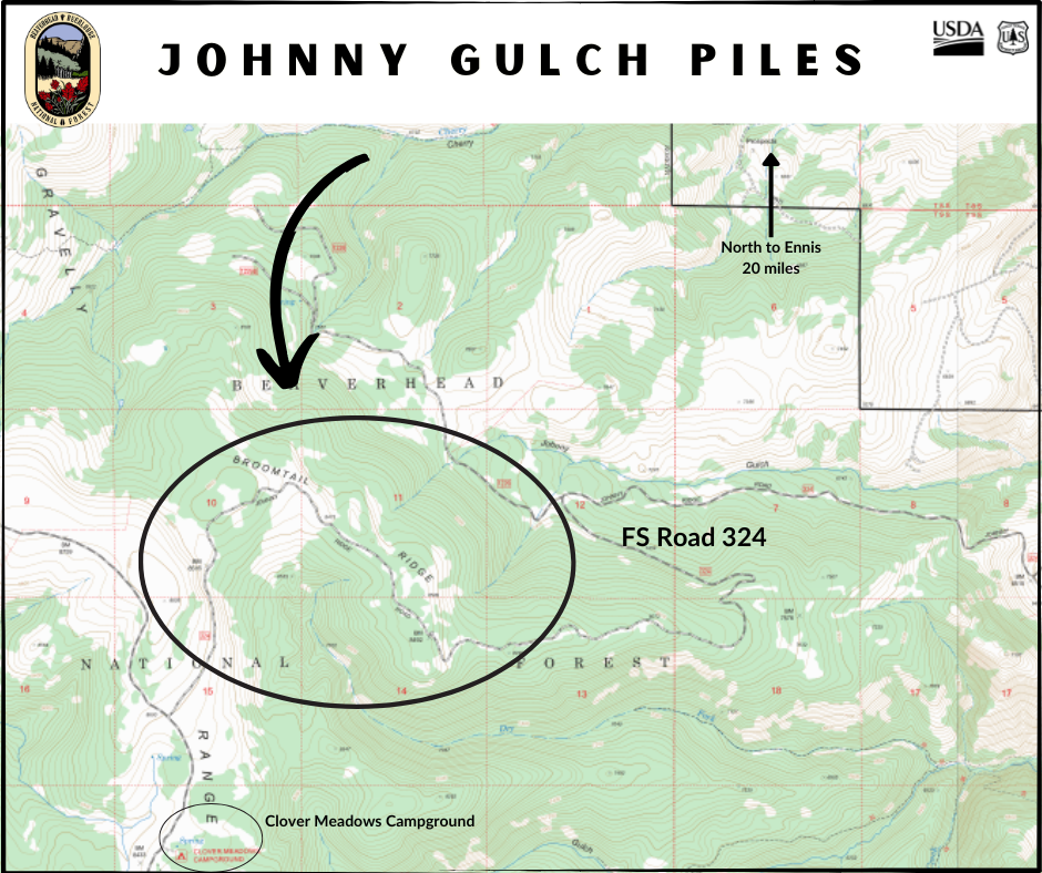
Madison Ranger District Pile Burning Locations 11 05 2024
Related Incident: Beaverhead-Deerlodge NF Prescribed Fire Operations
Publication Type: Announcement
Pile burning locations for the Madison Ranger District include the following:
Johnny Gulch
20 miles south of Ennis
Along Forest Service Road 324, just north of Clover Meadows Campground
Piles remaining from fire suppression operations on the Monument Fire of 2018
Happy Fire Update November 5 2024 11 05 2024
Related Incident: Happy
Publication Type: News
The Happy Fire has provided the opportunity to reintroduce fire back into this landscape. The local management team based on the Sequoia National Forest in coordination with the Sierra National Forest and Kings Canyon National Park has been monitoring and managing the benefits this fire is providing since it began on July 16, 2024.
Forest Officials actively engaged to manage the fire on October 31, 2024 through November 3, 2024 with ignitions north of Hwy 180 along the South Fork of the Kings River, changing the status from a monitored fire to a managed fire.
Aerial and hand crew ignitions over a recent two day period contributed to over 4000 acres of treatment accomplished. Ideal fire effects are providing benefits to natural resources with the treated acreage to 10,571 acres.
Fire activity for the Happy Fire is expected to decrease and smoke has cleared out with the weather change as the fire is now in monitoring status. As the vegetation dries out, smoldering may increase and produce more smoke.
The fire will be monitored until rainfall and winter-like conditions put the fire out. Managed fire can help achieve resource objectives and restore and maintain fire as an essential ecological process. This will be the last update unless there is a significant change in the fire.
Blue Front Fire Update 1152024 11 05 2024
Related Incident: Blue Front Fire
Publication Type: News
Start Date: October 28, 2024
Cause: Unknown
Size: 323 acres
Containment: 75%
Location: 4 miles west of Alto, 9 miles northwest of Ruidoso, located in the Blue 2 wildfire footprint in the White Mountain Wilderness
Resources: One Type 6, USFS engine
Types of vegetation in the area (aka fuels): Grass, shrubs, dead/down fuel
Strategy: Full Suppression with direct and indirect tactics
Road Closures: None
Smoke: There is no smoke showing from the Blue Front Fire
Update: Due to the weather and firefighting efforts there has been no perimeter growth on the Blue Front Fire over a week. Precipitation in the form of snow and rain fell over the fire Sunday and Monday further minimizing any observed fire behavior. Last night’s Infrared flight was canceled due to weather conditions, however, containment has increased to 75%. Additional containment lines will be identified, and an updated map will be released tomorrow.
Fire equipment and personnel remain assigned to the Blue Front fire. Although there are fewer resources, if you are planning to travel in and around the fire area, please use caution and drive carefully.
Weather: Precipitation has diminished. Today is forecasted to be sunny and temperatures in the 50’s. Colder temperatures and snow in the higher elevations are forecast to return on Thursday.
Pile Burn Update 11 05 2024
Related Incident: Lolo National Forest Prescribed Fire Operations
Publication Type: News
Lolo NF fire and fuels staff completed 207 acres of pile burning yesterday across many of our districts, work will continue today and throughout the rest of this week, as conditions allow.
Missoula Ranger District: Firefighters will continue pile burning up to 60 acres, 3.5 miles northwest of Lolo Hot Springs .5 miles south of Wagon Mountain and Howard Creek junction. Smoke may be visible from Highway 12.
Ninemile Ranger District: The district plans to burn up to 24 acres of piles located in the Cromwell Creek drainage 3 miles west of District Office. Smoke may be visible from the Ninemile Valley, Alberton and Interstate 90.
Superior Ranger District:
The Superior Ranger District will continue pile burning on the Hall Wood project area located 5 miles north of Superior. The district also plans to pile burn on the West End project located southwest of Haugan. Smoke may be visible from Superior and Interstate 90.
Plains/Thompson Falls Ranger District:
District personnel plan to conduct up to 60 acres of piles on two different project areas located in the Prospect Creek drainage and 11 miles west of Thompson Falls. Smoke may be visible from Highway 200 and Camas Prairie.
Seeley Lake Ranger District:
Firefighters will conduct up to 50 acres of pile burning on the Westside Bypass Project area located 4 miles northwest of Seeley Lake. Smoke may be visible from Seeley Lake and Highway 83.
To learn more about pile burning visit: https://www.fs.usda.gov/main/lolo/fire.