
Incident Publication
Wisdom Ranger District Pile Burning Locations 11 04 2024
Related Incident: Beaverhead-Deerlodge NF Prescribed Fire Operations
Publication Type: Announcement
Pile burning locations for the Wisdom Ranger District include the following:
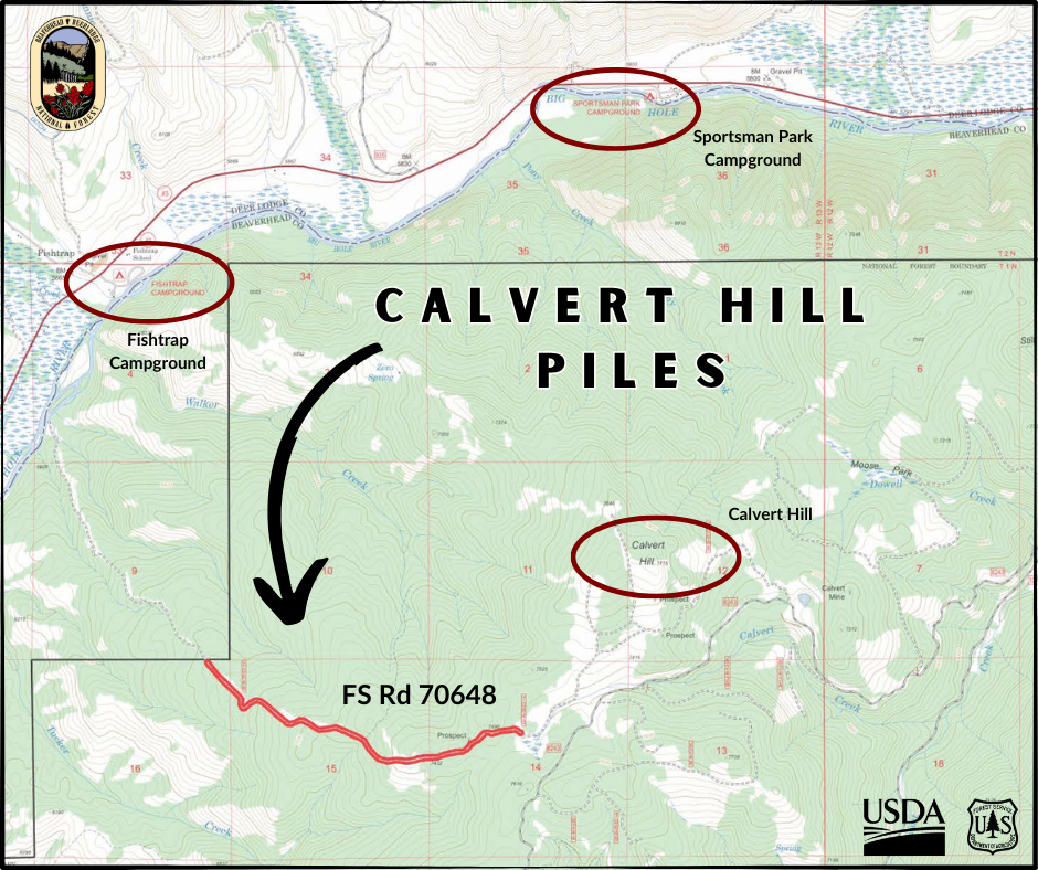
Calvert Hill
19 miles NE of Wisdom
3 miles SE Fishtrap CG
FS Road 70648
Calvert Creek drainage
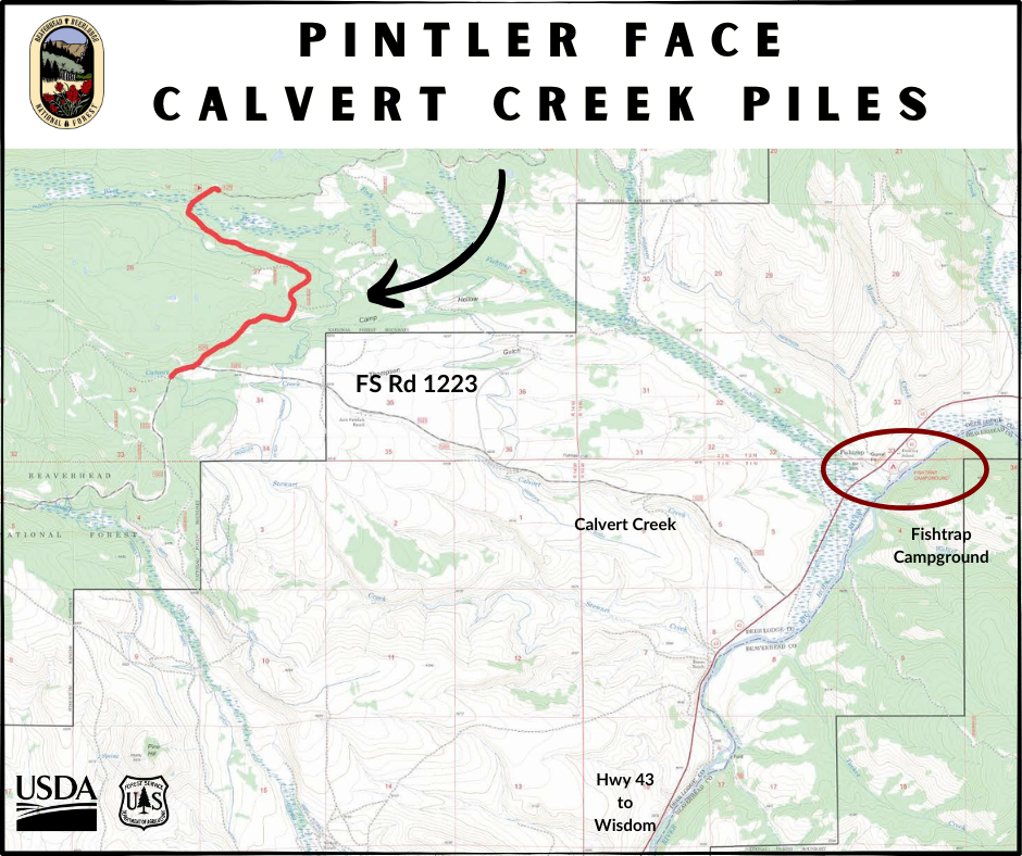
Pintler Face – Calvert
20 miles N Wisdom
5 miles NW Fishtrap CG
FS Road 1223
Calvert Creek drainage
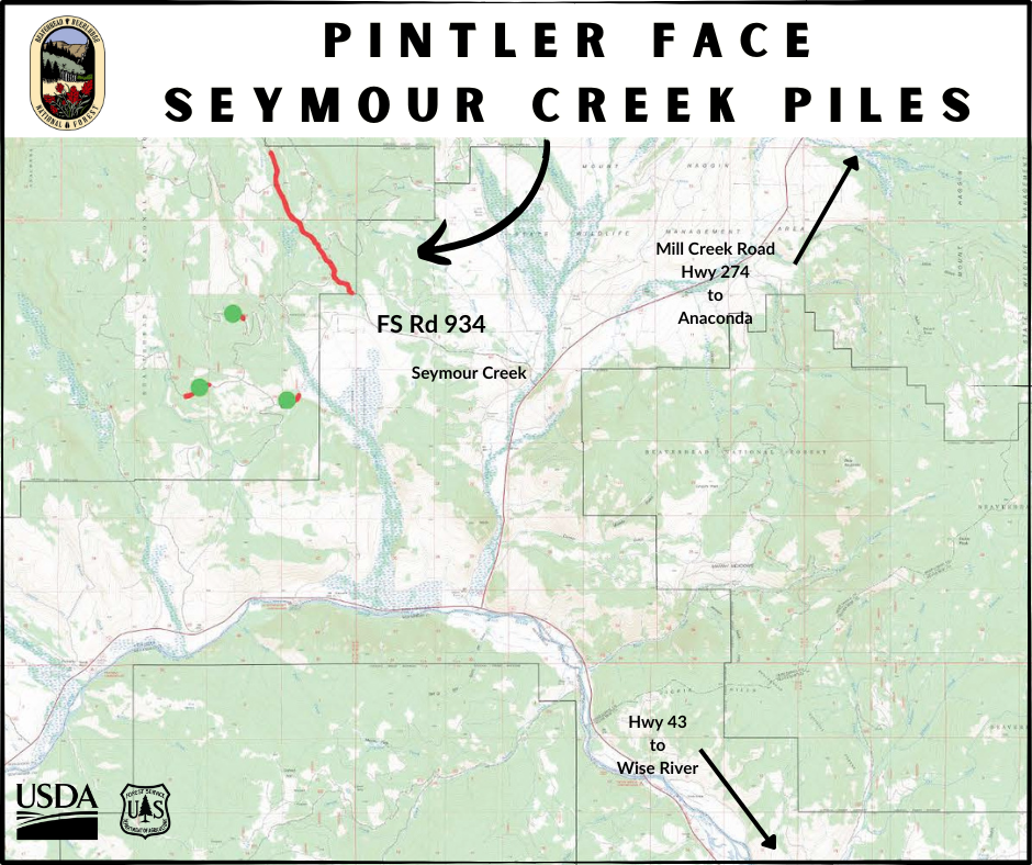
Pintler Face – Seymour
15 miles NW Wise River
W of Mill Creek Hwy 274
FS Road 934
Seymour Creek drainage
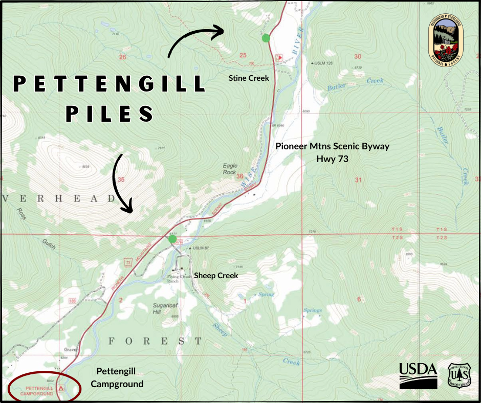
Pettengill Creek
6 miles SW Wise River
Off PMSB Hwy 73
Stine Creek and Sheep Creek
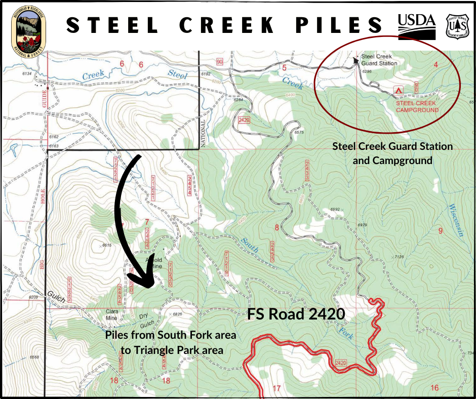
Steel Creek
6 miles E of Wisdom
S of Steel Creek Guard Station & CG
FS Road 2420
From South Fork to Triangle Park area
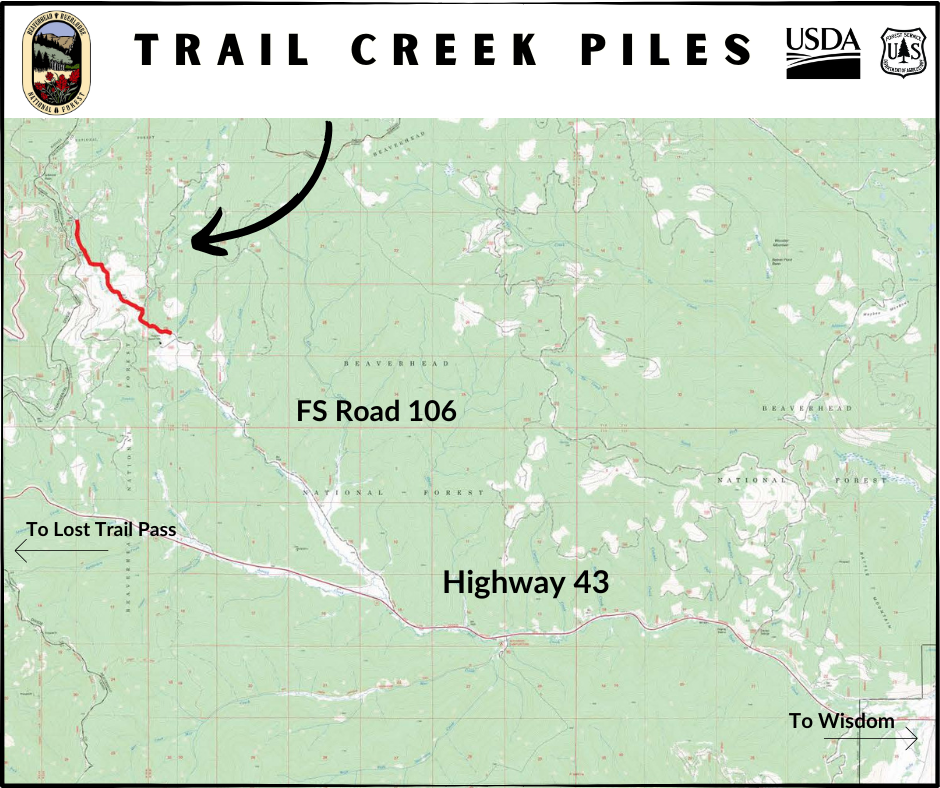
Trail Creek
20 miles W of Wisdom
FS road 106, off Highway 43
Butte Ranger District Pile Burning Locations 11 04 2024
Related Incident: Beaverhead-Deerlodge NF Prescribed Fire Operations
Publication Type: Announcement
Pile burning locations for the Butte Ranger District include the following:
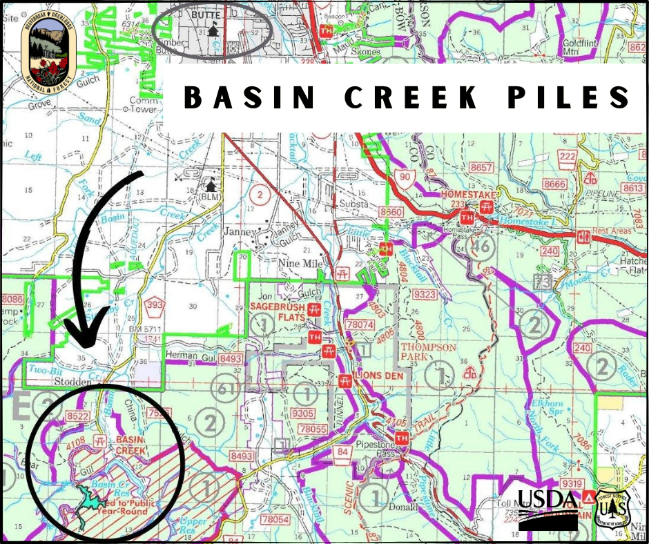
Basin Creek
10 miles south of Butte
Basin Creek Road 393 and in previously treated Basin Creek project area
(10,000+ hand piles)
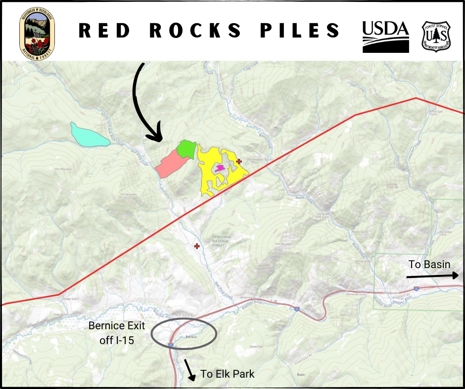
Red Rocks
22 miles north of Butte
2 miles north of Bernice exit off Interstate 15
In Red Rocks drainage
Winter pile burning plans for San Juan NF 10 23 2024
Related Incident: 2025 San Juan National Forest Prescribed Fire Program
Publication Type: News
Slash pile burning planned this fall, winter on San Juan National Forest
Pile burning operations will begin in October 2024, extend into spring 2025
Durango, Colo., Oct. 23, 2024— The San Juan National Forest plans to burn slash piles this fall and winter generated from forest thinning and timber sales. Thinning projects improve forest health and wildlife habitat and reduce the risk of wildfire near private residences and infrastructure. Slash from these projects is piled and burned to remove the debris that could fuel wildfire.
Pile burning will begin as early as this month when there is sufficient snow or rain present to prevent fire spread and will continue as long as conditions allow, possibly through April 2025. Firefighters will ignite and monitor pile burning activities while heat is present. These activities should not affect public access or use of the forest.
Columbine Ranger District plans to burn slash piles near the following locations: Saul’s Creek (50 acres, 100 piles) near Forest Service Road 755. Fossett Gulch (17 acres, 100 piles) near FSR 841. Baldy Mountain (117 acres, 10 piles) near FSRs 69 and 601.
Dolores Ranger District plans to burn slash piles near the following locations: Haycamp Mesa area (250 acres, 800 piles) near FSRs 556, 556.G and 492, south of Beef Pasture Reservoir. Boggy Draw area (14 acres, 4 piles) near FSR 526.B in the Beaver Rim Gravel Pit. Taylor Mesa area (390 acres, 134 piles) near FSRs 545 and 545.J. Salter area (400 acres, 400 piles) near FSRs 514, 504, 519 and 293, northwest of Salter Y. Lake Canyon and Glade areas (3100 acres, 1400 piles) near FSRs 506, 504, 508, 512, 514, 215 , 270, 216 and 218 near Glade Canyon. Smoke may be visible from Highway 184, Highway 145, and U.S. Route 491.
Pagosa Ranger District plans to burn slash piles near the following locations: Turkey Springs Piles, 15 acres, adjacent to Piedra Road and FSR 629. Longest Mile Piles, 7 acres, adjacent to Piedra Stock Driveway Trail. Buckles Lake Road Piles,13 Acres, adjacent to FSR 663 and US Highway 84. Coyote Creek Piles, 15 miles, between FSR 663 and Alpine Lakes Ranch subdivision. Mariposa Timber Sales Piles, 326 acres, 9 miles, near the FSR 024. Huerto Timber Sale Piles, 596 acres, between the Weminuche Valley and Williams Reservoir. Fawn Gulch Piles, 16 acres, north of FSR 666 and Log Park subdivision. Quartz Piles, 20 acres, adjacent to FSR 684.
Burning will only occur when all conditions of the state-issued smoke permit are met. Learn how smoke from wildfires, prescribed burns and pile burns may affect your health by visiting the Colorado Department of Public Health website: https://www.colorado.gov/pacific/cdphe/wood-smoke-and-health.
For additional information on the San Juan National Forest prescribed fire program, visit InciWeb (https://inciweb.wildfire.gov/incident-information/cosjf-2024-san-juan-national-forest-prescribed-fire-program). For information on current conditions and recreation opportunities on the San Juan National Forest, call (970) 247-4874, visit the forest website, or follow us on social media (Twitter and Facebook).
-USDA-
USDA is an equal opportunity provider, employer, and lender.
Shoe Fire Daily Update for 11 09 2024
Related Incident: Shoe Fire
Publication Type: News
![]() SHOE FIRE DAILY UPDATE
SHOE FIRE DAILY UPDATE
November 9, 2024
Quick Facts:
Location: Shasta County, CA │ Start Date: Wednesday, October 9, 2024, at 6:57 PM │ Cause: Human
Size: 5,124 │ Containment: 100%│ Vegetation: Timber, Chapparal │ Total Personnel Assigned: 118
Type 4 team lead by IC Steffen Joss, with trainee’s Terra Perkins and Mike Samaniego assumed command of the fire at 0600 this morning.
Today the fire has been deemed 100% contained, but firefighters will still be patrolling the perimeter of the fire to ensure the minimal smoldering stays within the containment lines. An Excavator will be in Madrone Campground to continue working on cleaning up the hazards caused by the fire. Additional heavy equipment will be on the west side contingency line continuing the repair work on Curl Ridge Jeep Trail, and on the east side contingency line near Garden Ridge completing the repair work in the area. Road graders will continue the repair work on the Salamander Loop.
WEATHER: Sunny skies with lighter winds prevailed today. Relative humidities were in the mid to low 20's with temperatures in the 60's.
Dry weather is expected through the weekend with a cooling trend continuing. Light northeasterly/ downslope winds are expected in the morning, becoming southwesterly in the afternoon. Wetting rain, cooler temperatures and gusty southerly winds spread in Sunday night through Monday.
CLOSURES AND SAFETY:
- Fenders Ferry Road at Pit River 7 Bridge: West-Bound Fenders Ferry Road (Also known as 34N17 - Forest Service Road 27) at the Pit River Bridge/Pit 7
- Ferry Road is closed at McCloud Bridge: East-Bound Fenders Ferry Road at the McCloud River Bridge
- A temporary Forest closure is in effect https://www.fs.usda.gov/detailfull/stnf/alerts- notices/?cid=stelprdb5392380
Email: 2024.shoe@firenet.gov
Facebook: https://www.facebook.com/2024ShoeFire/
Incident Website: https://inciweb.wildfire.gov/incident-information/cashf-shoe-fire-1152024
Forest Website: https://www.fs.usda.gov/stnf
Fire Weather Forecast: https://www.weather.gov/wrh/CAFW?area=ECC005
Fire Information Line: 530-275-1587 (Staffed 8:00 AM – 4:30 PM)
Blue Front Fire Update 1142024 11 04 2024
Related Incident: Blue Front Fire
Publication Type: News
Start Date: October 28, 2024
Cause: Unknown
Size: 323 acres
Containment: 52%
Location: 4 miles west of Alto, 9 miles northwest of Ruidoso, located in the Blue 2 wildfire footprint in the White Mountain Wilderness
Resources: Three engines
Personnel: 21
Types of vegetation in the area (aka fuels): Grass, shrubs, dead/down fuel
Strategy: Full Suppression with direct and indirect tactics
Road Closures: None
Smoke: Smoke will be minimal
Update: Within the Blue Front Fire area fire risk is low with the development of rain, snow and higher humidity. Firefighters are working to complete containment lines around the Blue Front Fire.
The Type 3 organization transferred command to a Type 4 organization at 8 a.m. this morning. Weather dependent, firefighters will continue to engage in full suppression activities.
There are currently no closures in place, please use caution while traveling in the fire area, as there are still firefighters and equipment in the Blue Front fire area. Hunting season has begun, please know your target before you fire.
Weather: Precipitation began in the form of rain in lower elevations and snow on Sierra Blanca. It is forecasted to continue throughout the day, Monday.
November 4 2024 Pile Burn Update 11 04 2024
Related Incident: Lolo National Forest Prescribed Fire Operations
Publication Type: News
Conditions permitting, several districts on the Lolo National Forest are planning to conduct pile burning today to reduce the fuel loading created from previous management operations.
Missoula Ranger District: Firefighters will continue pile burning up to 66 acres, 3.5 miles northwest of Lolo Hot Springs off Forest Road 33 at the junction of Wagon Mountain Road and Howard Creek Road. Smoke may be visible from Highway 12 and Lolo Hot Springs.
Ninemile Ranger District: Firefighters will burn up to 51 acres of piles located in the Cromwell Creek drainage 3 miles west of District Office. Smoke may be visible from the Ninemile Valley, Alberton and Interstate 90.
Plains/Thompson Falls Ranger District:
Firefighters plan to conduct up to 50 acres of landing piles near Henry Peak southeast of Plains. Smoke may be visible from Highway 200.
Seeley Lake Ranger District:
Firefighters will conduct up to 40 acres of pile burning on the Westside Bypass Project area is located 4 miles northwest of Seeley Lake. Smoke may be visible from Seeley Lake and Highway 83.
Shoe Fire Daily Update for 11 03 2024
Related Incident: Shoe Fire
Publication Type: News
SHOE FIRE
DAILY UPDATE
November 3, 2024
Northwest Team 12
Email: 2024.shoe@firenet.gov
Incident Website: https://inciweb.wildfire.gov/incident-information/cashf-shoe-fire
Forest Website: https://www.fs.usda.gov/stnf
Fire Weather Forecast: https://www.weather.gov/wrh/CAFW?area=ECC005
Fire Information Line: 530-338-0317 (Staffed 8:00 AM – 8:00 PM)
Quick Facts:
Location: Shasta County, CA │ Start Date: Wednesday, October 9, 2024, at 6:57 PM │ Cause: Human
Size: 5,124 │ Containment: 96%│ Vegetation: Timber, Chapparal │ Total Personnel Assigned: 282
Extremely wet conditions persisted throughout the fire area yesterday, impacting operations across all divisions on the fire. Roadways were saturated and slippery making it too hazardous for vehicles and equipment to travel. Fire resources had the most success continuing to repair contingency line with four pieces of heavy equipment working northward along Curl Ridge. Another excavator repaired mechanically constructed containment line on the north side of the fire. More fire resources are being released from the incident as they reach the end of their assignment, including another 20-person hand crew and a heavy helicopter. A warming and drying trend is moving into the area today and fire managers are anticipating increased opportunities to complete remaining repairs as access improves due to drier roads. Two road graders will be working east of McCloud Bridge along Fenders Ferry Road today. Heavy equipment will continue working on fire suppression repairs along Curl Ridge as well as on the south and east sides of the fire today. A local Type 3 Incident Management Team from the Shasta-Trinity National Forest will arrive today for a briefing on the status of remaining work. This incoming team will shadow NW Team 12 tomorrow as they prepare to take command of the incident Tuesday morning.
WEATHER: High pressure will strengthen over the western states today kicking off a warming and drying trend. An upper-level disturbance will move through the region on Monday to slow the warming for a day. High pressure over the inland western states will result in a northwest to northeast gradient over northern California. This pattern is well known to result in warmer than normal temperatures and dry conditions both day and night. Temperatures are expected to increase to the mid-50s to mid-60s and winds will be north to northeast with gusts 15-20 mph.
CLOSURES AND SAFETY:
• Fenders Ferry Road at Pit River 7 Bridge: West-Bound Fenders Ferry Road (Also known as 34N17 - Forest Service Road 27) at the Pit River Bridge/Pit 7
• Ferry Road is closed at McCloud Bridge: East-Bound Fenders Ferry Road at the McCloud River Bridge
• A Temporary Flight Restriction is in place over the fire area https://tfr.faa.gov/save_pages/detail_4_2632.html. Drones are prohibited from flying in fire areas.
• A temporary Forest closure is in effect https://www.fs.usda.gov/detailfull/stnf/alerts-notices/?cid=stelprdb5392380
Blue Front Fire Update 1132024 11 03 2024
Related Incident: Blue Front Fire
Publication Type: News
Start Date: October 28, 2024
Cause: Unknown
Size: 323 acres
Containment: 52%
Location: 4 miles west of Alto, 9 miles northwest of Ruidoso, located in the Blue 2 wildfire footprint in the White Mountain Wilderness
Resources: (3) type 6 engines from the USFS and BLM and 1 helicopter
Personnel: 25
Types of vegetation in the area (aka fuels): Grass, shrubs, dead/down fuel
Strategy: Full Suppression with direct and indirect tactics
Road Closures: None
Smoke: Light smoke may be visible from the surrounding areas
Update: There has been no new growth of the Blue Front Fire in the last three days. Firefighters are working to make sure the perimeter of the South Fork area is secure. Crews will be extinguishing any interior heat spots that might still exist.
Firefighters are utilizing the South Fork Trail to further accomplish their suppression efforts. When the work is complete and public access is deemed safe, a public announcement will be released to advise that the South Fork Trail is officially open. The Crest Trail is being used to access the fire area from the North and is currently open.
There are currently no closures in place, please use caution traveling in the fire area there are still firefighters and equipment in the Blue Front fire area.
Weather: Cooler temperatures have been observed with the approaching front. There is a chance of precipitation in the form of rain and snow beginning Sunday night.
Evacuations: Bonito Corridor remains in “Ready” status
Final Update for the Pack Trail Fire November 3rd 2024 11 03 2024
Related Incident:
Publication Type: News
This is the final Update for the Pack Trail Fire
People & Equipment: 73 Personnel, 2 Crews, 1 Local Engine, 1 Helicopter, 1 Ambulance
Current Situation: The Pack Trail Fire is 89,930 acres, Fire Confinement 95%
Operations – Recent snowfall has restricted access to a large area of the fire perimeter and is expected to persist in the days ahead. The fire is in a patrol and monitor status as interior smoke and heat are still present. The fire will be monitored by the Bridger-Teton and Shoshone National Forests as needed. Winter weather and increased fuel moistures should continue to reduce any threats of continuing fire activity. Suppression repair activities have been completed in all areas still accessible to resources.
Safety – Residents and visitors are reminded to exercise extreme caution when dealing with fires or other possible ignition sources. Please use caution while driving near the fire areas, especially on narrow secondary roads due to snow or ice accumulation. Be Very Careful on reopened roads in and near the fire area. Check with WY-DOT for updated road conditions, especially if you are planning to travel on US-26 across the Continental Divide.
Weather—Widespread snow showers are expected to continue through Wednesday as additional disturbances move across the area and colder air is ushered in. Weather patterns will be seasonal with intermittent snow and cold temperatures. The cold temperatures and snow will continue to decrease any fire activity. The weather forecast is predicted to bring fire-season ending conditions.
Evacuations – The Fremont County Emergency Management Agency has lifted all evacuation levels for the Union Pass subdivision, Lava Mountain Lodge, Triangle C Ranch, and Old Mackenzie Ranch, effective October 30, 2024. All evacuation areas within the Pack Trail Fire have been lifted. See the Fremont County Emergency Management Facebook Page or the Teton County Emergency Management website for additional information.
Road Closures – The Union Pass Road on the Pinedale Ranger District (BTNF) from Mosquito Lake to the Moon Lake Road on the Wind River District (SHO) will be open effective 6:00am Monday, November 4, 2024. Moon Lake Road will be open effective 6:00am Monday, November 4, 2024.
Forest Closures - Closure Order #04-03-24-317 will be rescinded effective 6:00am Monday, November 4, 2024. The forest areas described in Closure Order #04-03-24-317 are now open.
For more information, visit: Bridger-Teton Forest website - https://www.fs.usda.gov/btnf Facebook: USDA Forest Service - Shoshone National Forest Pack Trail Inciweb: https://inciweb.wildfire.gov/incident-information/wybtf-pack-trail-fire
November 2 Front Country Prescribed Fire Updates 11 02 2024
Related Incident: Front Country Prescribed Fire
Publication Type: News
7:00 p.m. Ignitions on the Headquarters Unit of the Front Country Prescribed Fire have been successfully completed, with approximately 100 acres treated during the past two days. Crews were successful in introducing low-to-moderate intensity fire on the landscape and have removed fuels, including grasses and low shrubs. Another goal of this prescribed fire was to raise the bottoms of the canopies of trees and to increase crown spacing within the fire area. To do this, some low branches on trees may burn in addition to the grasses and nearby brush. Raising the “crown base height” of trees decreases the likelihood that a future wildfire would move into the canopies of the trees. This work will help serve as a fuel break against potential future wildfires.
Fire crews will remain on site overnight. Visibility along U.S. Highway 36 has improved and smoke will continue to linger. U.S. Highway 36 inside Rocky Mountain National Park has reopened in both directions.
Fire Managers at Rocky Mountain National Park would like to thank all of the personnel involved in this operation over the past two days. Numerous cooperators, including federal, state, and local partners have been working with NPS staff in a variety of roles to ensure the safety of both firefighters and the visiting public. An evening video update will be available on Rocky Mountain National Park's social media and Rocky's YouTube Channel.
4:00 p.m. Crews have completed ignitions for the day. Firefighters will be patrolling unit boundaries until dark, when night shift will begin patrolling through the night. Due to low visibility and smoke from late afternoon ignitions, highway 36 from Beaver Meadows Visitor Center to Bear Lake Road junction was temporarily closed. Visitors traveling to Rocky Mountain National Park should use U.S. Highway 34 via Fall River Entrance to enter and exit Rocky Mountain National Park.
2:30 p.m. Crews have completed the first section of today's prescribed fire and are moving on to another section, which will move operations south of Highway 36 and the Beaver Meadows Entrance Station. Motorists are asked to be vigilant as fire operations continue along the roadway. All eastbound traffic continues to be routed through the Fall River Entrance/U.S. Highway 34 back to Estes Park.
1:00 p.m. Winds have shifted to being out of the east/southeast, which has caused smoke to largely blow into Rocky Mountain National Park. Crews will be reconfiguring to continue firing operations with the wind shift.
11:30 a.m. Weather & conditions are favorable for crews to continue with firing operations today, Saturday, November 2. Approximately 50 firefighters representing several cooperating agencies will be part of today’s operations. Ignitions began at 11:00 a.m. just south of Highway 36, south of the Beaver Meadows Entrance Station.
Visitors traveling to the east side of Rocky Mountain National Park are encouraged to use Fall River Entrance via U.S. Highway 34 when entering and exiting the park. Expect traffic delays and smoke on the roadway along U.S. Highway 36 inside RMNP.
Today, U.S. Highway 36 will be open to west-bound traffic only from Beaver Meadows Visitor Center to Beaver Meadows Entrance. Motorists are encouraged to use caution when driving on U.S. Highway 36 between the Beaver Meadows Visitor Center and Bear Lake Road due to smoke, visibility, and fire crews working along the road. To exit RMNP on the east side of the park, use Fall River Entrance/U.S. Highway 34 to return to Estes Park.
Smoke impacts west of the Beaver Meadows Entrance Station and Bear Lake road are expected to be minimal.
In person fire information will be available at Beaver Meadows Visitor Center until 4:30 p.m. Additional updates will be available on the park's official social media channels and on this InciWeb page