
Incident Publication
WYDOT portions of US 14 and US 14A open 10 14 2024
Related Incident: Elk Fire 2024
Publication Type: Closures
WYDOT opens portions of US 14 and US 14A previously closed due to Elk Fire
Sheridan, Wyo – The Wyoming Department of Transportation has opened US 14 from Greybull to Burgess Junction and US 14A from Burgess Junction to Lovell.
US 14 Burgess Junction east to Dayton remains closed.
Due to the heavy fire-fighting traffic of crews working the Elk Fire north and east of these routes, motorists are asked to watch for their presence and yield to them when necessary.
The Bighorn National Forest Service has closed access to the following forest service roads. These roads are within the fire boundary and are not accessible to motorists. These roads include Forest Service Road 26 /Dead Swede to Red Grade on US 14 and Forest Service Roads 14,15, and 178 on US 14A.
The Wyoming Highway Patrol will be monitoring the closure gates at Dayton and Burgess Junction.
Middle Fork Complex NellieBulldogFlat Fires PostFire BAER Soil Burn Severity Map Released 10 14 2024
Related Incident: Boise NF Post-Fire BAER 2024
Publication Type: News
Middle Fork Complex (Nellie-Bulldog-Flat Fires)
Post-Fire BAER Soil Burn Severity Map Released
October 14, 2024
USDA Forest Service Burned Area Emergency Response (BAER) specialists recently completed their data gathering and analysis for the Middle Fork Complex wildfire burned areas to produce a post-fire Soil Burn Severity (SBS) map.
The BAER assessment team used initial remote sensing imagery with their field-validated soils data, to develop and produce a map showing soil burn severity levels for the burned area. The SBS is broken into four different classes: unburned/very low (green), low (blue), moderate (yellow), and high (red). For more information on these different SBS classifications, see the BAER Information Brief at: Idbof Boise Nf Postfire Baer 2024 - | InciWeb (wildfire.gov).
The BAER SBS map and data display categories of unburned/very low, low, moderate, and high soil burn severity in different colors for the different categories along with a table displaying these GIS data totals:
- For the Nellie Fire, approximately 66% of the 50,158 acres analyzed by the BAER team are either unburned/very low or low soil burn severity, while 30% sustained a moderate soil burn severity, and about 4% were identified as having high soil burn severity.
- For the Bulldog Fire, approximately 74% of the 11,420 acres analyzed by the BAER team are either unburned/very low or low soil burn severity, while 25% sustained a moderate soil burn severity, and about 1% were identified as having high soil burn severity.
- For the Flat Fire, approximately 67% of the 3,762 acres analyzed by the BAER team are either unburned/very low or low soil burn severity, while 22% sustained a moderate soil burn severity, and about 11% were identified as having high soil burn severity.
There are several types of fire severity and intensity maps that you may see. Although the maps look different for the same fire, they are accurate. This is because fire severity or intensity are different metrics of the fire effects on a specific resource such as soils, tree canopies, vegetation or wildlife habitat. Burned Area Emergency Response (BAER) maps are primarily measures of fire effects on soils. See also Fire Intensity vs. Soil Severity Effects BAER Information Brief at: Idbof Boise Nf Postfire Baer 2024 - | InciWeb (wildfire.gov).
The BAER team relies on their final soil burn severity map to produce data, which they are using in their subsequent modeling and determination of post-fire runoff, erosion, and sedimentation. The BAER team, and the US Geological Survey (USGS) utilize the soil burn severity map as an analysis tool to estimate post-fire watershed response to precipitation events. In specific areas that experienced moderate to high burn severity, there could be increased runoff from steep hillslopes which could result in increases of post-fire soil erosion, sedimentation, and potential debris flows.
The Middle Fork Complex (Nellie-Bulldog-Flat) SBS map can be downloaded at the Boise NF Post-Fire BAER 2024 InciWeb site: Idbof Boise Nf Postfire Baer 2024 Information | InciWeb (wildfire.gov) under the “Maps” tab.
BAER SAFETY MESSAGE: Everyone near and downstream from the burned areas should remain alert and stay updated on weather conditions that may result in heavy rains and increased water runoff. Flash flooding may occur quickly during heavy rain events--be prepared to act. Current weather and emergency notifications can be found at the National Weather Service website: www.weather.gov/boi/.
###
Shoe Fire Daily Update for 10 14 2024
Related Incident: Shoe Fire
Publication Type: News
Fire Information: 530-338-0317
Media Line: 909-855-4233
Hours: 08:00am to 7:00pm
Location: Shasta County, CA
Start Date: Wednesday, October 9, 2024, at 6:57 p.m.
Cause: Human caused, still under investigation
Size: 3,231 acres
Percent Contained: 7%
Vegetation: Timber, Chapparal
Number of Personnel Assigned: 485
Last night, during the evening shift on October 13, activity continues to increase in the Beartrap area.
Additional resources have arrived and been put into place to bolster existing equipment and personnel. Fire fighters have reported successful firing operations along with the utilization of dozer lines in the north and west sides of the fire to create containment lines. The south and east sides of the fire, primarily in the Beartrap creek continue to have an increase in fire behavior. Dozers have had some limited capabilities due to road access. Aircraft and dozer operations will remain a key priority to create access to the south and east sides of the fire. Dozers continue to work to gain better access for direct fire line attack. The safety of our firefighters is priority and they will continue to make progress in a safe manner.
Fire is progressing northward fueled by down slope and down valley winds. Constant changes in wind direction will be observed today along with wind gusts, gusting between 10 to 15 miles per hour.
Mandatory evacuations remain in place for zone LKH-1448-B. Residents who have not evacuated are encouraged to do so. Evacuation information and alerts can be found by visiting protect.genasys.com
Information staff for the Shoe Fire are working diligently to provide timely and accurate information to the public. Fire updates can be found on the Shoe Fire 2024 Facebook page: www.facebook.com/2024ShoeFire/
Additionally, the Shoe fire was named after Shoeinhorse Mountain which is in close proximity to this incident.
WEATHER: The forecast for the area indicates a warming trend over the next few days with increased winds.
EVACUATIONS: Zone LKH-1448-B
ROAD CLOSURES:
- Fenders Ferry Road at Pit River 7 Bridge: West-Bound Fenders Ferry Road (Also known as 34N17 - Forest Service Road 27) at the Pit River Bridge/Pit 7
- Ferry Road is closed at McCloud Bridge: East-Bound Fenders Ferry Road at the McCloud River Bridge
FIRE SUMMARY OCTOBER 14 2024 10 14 2024
Related Incident:
Publication Type: News
The Central Idaho Dispatch Zone is at HIGH Fire Danger
There have been no new fires reported on the Salmon-Challis National Forest since the last update on Monday, October 7, 2024. To date, there have been 64 wildfires reported on the Salmon-Challis National Forest. 53 of the fires have been declared out.
Mowitch (September 29): is approximately three (3) miles north of Indian Creek on the Middle Fork Ranger District in the Frank Church River of No Return Wilderness. On October 9, 2024, the Mowitch and Birch fires merged and are now being reported as the Birch Fire. The fire is burning in grass, brush, spruce, fir, and ponderosa pine. The fire can be found on InciWeb at https://inciweb.wildfire.gov/incident-information/idscf-birch-fire.
Nugget (September 13): is located approximately 40 miles west of Salmon on the North Fork Ranger District in the Frank Church River of No Return Wilderness. The 994 acre fire is burning in fir. The fire is surrounded by and in fire scars from 2005, 2013, and 2015. Fire managers are recommending the public do not enter the Nugget and Cradle Creek drainages. The fire can be found on InciWeb at https://inciweb.wildfire.gov/incident-information/idscf-nugget-fire.
Garden (September 8): is located approximately two (2) miles southwest of the confluence of Panther Creek and the Main Salmon River on the North Fork Ranger District in the Frank Church River of No Return Wilderness. The fire is being managed by a Complex Incident Management Team and is being reported separately. The fire can be found on InciWeb at https://inciweb.wildfire.gov/incident-information/idscf-garden-fire.
Vanity (September 3): is located approximately 42 miles west of Challis on the Middle Fork Ranger District. The approximately 600 acre fire is burning in subalpine fir and is surrounded by the 2012 Halstead Fire. Fire managers are using a point protection strategy (a wildfire response strategy, which protects specific assets or highly valued resources from the wildfire without directly halting the continued spread of the wildfire) to minimize exposure to fire personnel while protecting identified values. Specific values potentially threatened with this fire include Forest Service infrastructure. The fire can be found on InciWeb at https://inciweb.wildfire.gov/incident-information/idscf-vanity.
Red Rock (September 2): is located approximately two (2) miles east of Yellowjacket Guard Station on the Salmon-Cobalt Ranger District. A Complex Incident Management Team is managing the fire and information is being reported separately. The Napias Creek fire was determined to be a spot fire from the Red Rock Fire. The fire can be found on InciWeb at https://inciweb.wildfire.gov/incident-information/idscf-red-rock-fire.
Reynolds (August 22): is located approximately 21 miles northwest of Indianola, approximately 5.5 miles northwest of Horse Creek Hot Springs Campground on the Idaho/Montana border. Fire is estimated to be approximately 2,671 acres burning in spruce and fir. The Bitterroot National Forest is lead on this fire.
Birch (August 17): is located on the west side of the Middle Fork of the Salmon River on Norton Ridge on the Middle Fork Ranger District in the Frank Church River of No Return Wilderness. The 22,163 acre fire is burning in subalpine fir. The fire is surrounded by the 2022 Norton Fire and fire scars from the fires of 2000. The fire can be found on InciWeb at https://inciweb.wildfire.gov/incident-information/idscf-birch-fire.
Greyhound (August 11): is located approximately 46 miles northwest of Challis on the Middle Fork Ranger District. The 97 acre fire is burning in subalpine fir and lodgepole pine on the edge of the 2021 Boundary Creek Fire is 100% contained.
Wapiti (July 24): started on the Boise National Forest, burned onto the Sawtooth National, and around August 24th burned onto the Salmon-Challis National Forest. The fire has been turned back over to the local unit. Information can be found on InciWeb at https://inciweb.wildfire.gov/incident-information/idbof-wapiti-fire.
Thunder (July 24): The lightning fire is located approximately two (2) miles northwest of Williams Lake and approximately 12 miles southwest of Salmon. The fire is 100% contained and controlled, fire size is estimated to be 2,474 acres and is burning in timber, sagebrush, and grass.
Weather: Seasonably warm and very dry conditions will continue into early Wednesday with afternoon humidities in the teens and 20s. High confidence (>90% chance) supports a pattern change starting Wednesday into Thursday as a mix of rain, snow, wind, and much colder temperatures returns to our region along a cold front.
The forest is asking visitors to be aware of the HIGH fire danger for the Salmon-Challis National Forest. Ensure your campfire is dead out. If it is too hot to touch, it is too hot to leave! One Less Spark Means One Less Wildfire. Since June 1, Forest employees have found and extinguished at least 13 abandoned campfires.
Nationally, there are 31 uncontained large fires being managed under a full suppression strategy and 17 large fires managed under a strategy other than full suppression.
Visit our website at: www.fs.usda.gov/scnf/, ‘Like Us’ on Facebook @salmonchallisnf, and ‘Follow Us’ on X @salmonchallisnf.
####
Valley Fire Update 10 14 2024
Related Incident: 2024 Valley Fire
Publication Type: News
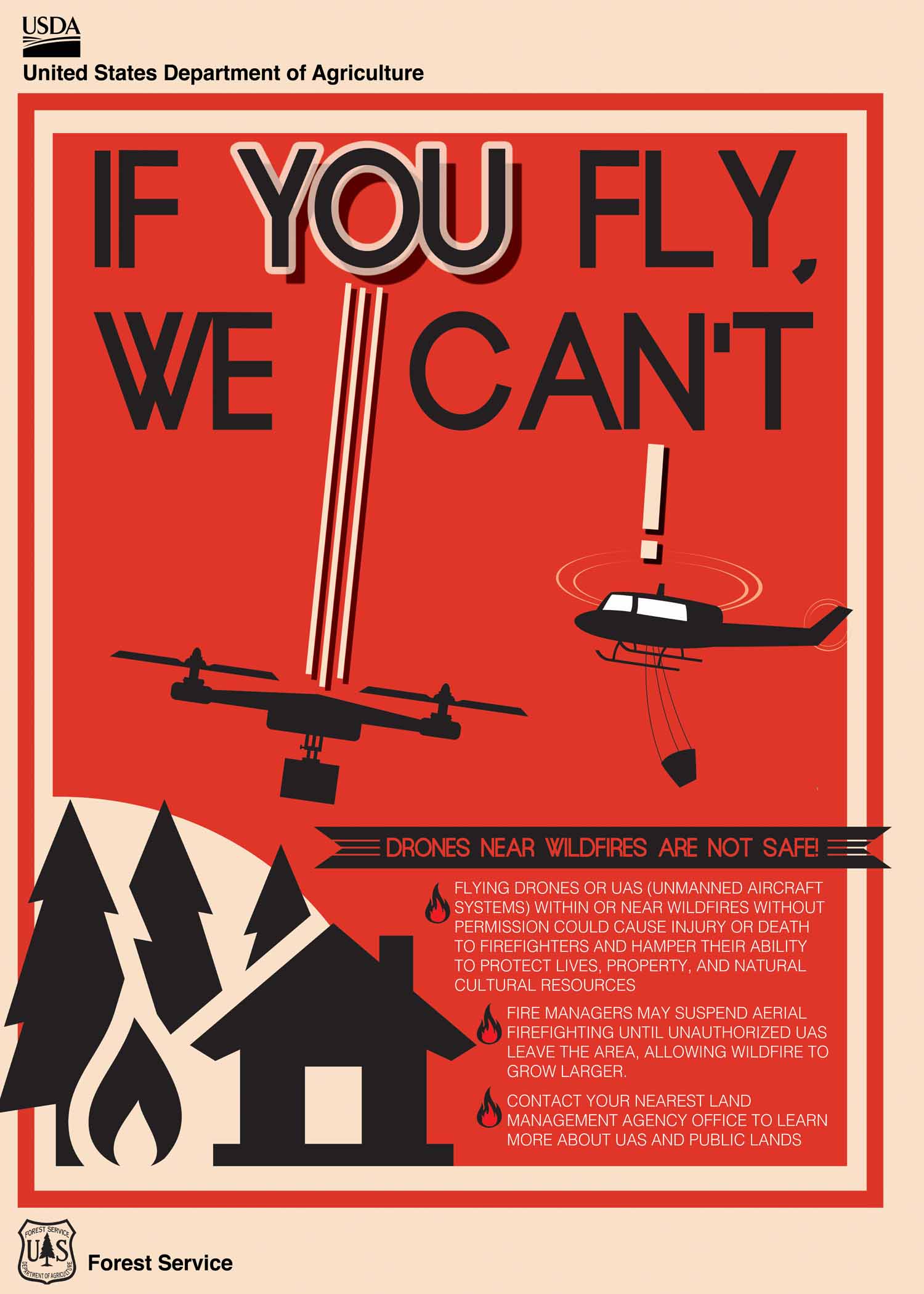
Incident Activity: Firefighting aircraft flights over the Valley Fire were suspended Sunday because another private drone was in the NO FLY ZONE. Please remember, flying drones in the fire area is NOT ALLOWED. Drones pose a safety risk for firefighting aircraft and medical rescues that require an airlift. Fire crews continue making progress in the north/northeast portion of the fire closest to Robie Creek and are extinguishing hot spots further inside the fire perimeter. Fire activity remains a safe distance from the community. Crews continue to monitor the south and west portions of the fire visible from Boise.
Repair of Fire Suppression Activity: The Valley Fire was stopped from reaching homes near the Boise Foothills thanks in large part to dozer containment line and handline built by firefighters on the ground. Equipment and resources are shifting to repairing fire suppression impacts which includes seeding and erosion control on containment lines. The southern area of the fire already has some suppression repair completed.
Recreation Message: The public is asked to be aware of closures prior to being in the area and honor closures. Closures are in place for public safety. Even if there is no visible fire activity, there could be hot spots, damaged trees that could fall, fire traffic, and other safety concerns.
Closures: All roads and trails on the Boise Front segment of the Boise River WMA west of Highway 21 and north of Warm Springs Avenue are closed to all entry until further notice. This closure also extends to all travel off roads and trails. There is a Boise National Forest Valley Fire Area, Road and Trail Closure. Contact the Mountain Home Ranger District at 208-587-7961.
Evacuations: The Robie Creek area is still in a "Ready" or Stage 1 evacuation status.
Fuels and Fire Behavior Advisory: Fuels, such as grasses and timber, are back to critically dry conditions in the Great Basin, with record-level dry conditions in many cases.
Weather: Dry conditions continue with highs averaging 70 degrees in the Valley Fire area and light winds.
Valley Fire Overview: The fire was reported Friday, October 4, 2024, about 1 mile east of Boise on the north side of Idaho State Highway 21. The fire was very visible from East Boise as it burned in mostly grassy fuels in the Boise Foothills. Quick work on initial attack stopped the fire from reaching nearby homes.
Tiger Creek Fire Daily Update 10 14 2024
Related Incident: Tiger Creek Fire
Publication Type: News
Current Situation: The fire remains at 534 acres and containment has increased to 73 percent with 348 firefighting resources still assigned. Crews have achieved containment on the Low Creek Ridge portion of the fire in challenging steep, difficult terrain. Line construction is complete, and hose lays are being removed in areas of containment. Roads crews have repaired and improved Mill Creek Road as well as the bridge leading to the fire area. Road repair will continue up the 65 road to the fire over the next several days.
Unmanned Aerial Systems (UAS) or drones continue to be utilized for aerial reconnaissance for detecting hot spots. As a reminder to the public, the use of personal aircraft (UAS) or drones is restricted within the temporary flight restriction (TFR) airspace over the fire is prohibited. Any unidentified aircraft within the TFR that is detected will result in all aerial operations over the fire to cease and pose a safety hazard to aerial and ground personnel.
Closures and Restrictions: Access through Forest Service Road (FSR) 65 up through FSR 64 to the junction with Indian Camp is closed. Government Mountain Road/FSR 6511 is closed from North Fork Walla Walla trailhead to the junction with FSR 65 at Tiger Saddle. Government Mountain Rd/FSR 6511 is open from the west to North Fork Walla Walla trailhead. The current fire danger rating is MODERATE and public use restrictions phase A for Umatilla National Forest are in effect. For more information regarding restrictions, please contact Umatilla National Forest Toll-free Information Hotline: 1.877.958.9663.
Weather: Today, mostly clear with a few afternoon clouds and temperatures in the mid-60s to mid-70s. Winds are expected to be out of the west at 5-8 mph and gusting 10-15 mph along ridgetops. Relative humidities will drop down to 25-30 percent.
A warm and dry trend is expected for the next two days. Tuesday, a chance of rainfall is forecasted to begin later in the day and into the next several days as a cold front arrives Wednesday. Breezy conditions may exist with the frontal passage.
Smoke: Walla Walla’s air quality for today is good to moderate. Some residents along Mill Creek may experience smoke as the fire continues to burn. Check out https://wasmoke.blogspot.com/?m=1 for more information.
Rail Ridge Daily Update 10 14 2024
Related Incident:
Publication Type: Announcement
Rail Ridge Fire Update
October 14, 2024
Central Oregon Wildfire Information: centraloregonfire.org
Email: 2024.railridge@firenet.gov – Phone: 541-208-7111
Social Media, Evacuation and Closure Information: https://linktr.ee/RailRidgeFire
Acres: 174,936 – Containment: 89% – Detection: 09/02/24 – Cause: Lightning – Personnel: 602
Forest visitors near the Rail Ridge Fire should be aware that Forest and BLM closures as well as fire restrictions around the Rail Ridge Fire remain in place.
NWCIMT8 will be transitioning with NWCIMT2 over the next couple of days. Team 8 has appreciated the support of the local landowners, community and agency administrators during their two week assignment on the Rail Ridge Fire. Team 2 personnel will arrive today and will take command of the fire tomorrow evening.
Operational Update: Yesterday, some areas of the fire near Cougar Ridge were putting up significant smoke in the late afternoon, but there was minimal increase in growth. On the northwest corner of the fire, firefighters finished handline that connects the north side of the Black Canyon Wilderness to the Cougar Ridge edge of the fire perimeter. Heavy equipment and crews continue to construct containment line along the Forest Service Road 3850 on the northwest corner of the fire. Containment line through the BLM and private property is complete and firefighters are prepping the cabins with sprinkler kits and putting in hose lays. Fire personnel continued to patrol the contained perimeter of the fire, searching for hot spots or any increase in fire behavior. Resources were engaged on the Forest Service Road 24 and Forest Service Road 2150 to clear these roads of hazards.
Today, in the northwest corner of the fire expect to see increased smoke and fire behavior as we continue to see the drying trend over the fire area. Crews will continue with the same work from yesterday to create containment line around the active fire area around Cougar Ridge. The team’s meteorologist and fire behavior analyst are monitoring any change in weather, as there is currently a 70% chance of rain midway through the week. This is likely to push cold air in front of it that would result in increased winds on the fire, increasing fire activity. Air operations have three Type 1 helicopters and are using air attack to respond to the fire as needed. Fire crews are continuing mop-up and removal of hazards from across the fire footprint.
The fire team and local agencies continue to work with local landowners, businesses, and affiliates who need access within the fire area closures. Due to the multitude of hazards within the fire area, these requests are being prioritized and official escorts are being provided as safety and availability of escorts are feasible.
Weather: High pressure will be overhead through Tuesday and dry conditions are expected through this period with min RH percent dropping into the upper teens to low 20’s. Winds will be light and mostly terrain driven through Tuesday with gusts of 10 to 15 mph during the peak heating hours of the afternoon. The weather pattern will make a major change on Wednesday, with much cooler conditions and possibly some rainfall and gusty winds.
Forest & BLM Closures / Evacuation Information / Fire Restrictions for the Rail Ridge Fire area can be found at: https://linktr.ee/RailRidgeFire.
Logan Fire Daily Update 10 14 2024
Related Incident: Logan Fire
Publication Type: News
Logan Fire Statistics:
Size: 14,828 acres
Completion: 10%
Total Personnel: 273
Reported: 9/8/24
Cause: Lightning
Weather: Temperatures will remain in the mid 60’s. The stormfront is predicted to approach by midday on Wednesday and may produce a thunderstorm or two. By Thursday, snow is expected at the fire. The fire could receive around ¼-inch to a ½-inch of precipitation from this weather event.
Current Situation: Yesterday, the firefighters confirmed containment of a portion of the fire perimeter, resulting in the black lines you see on the map today. There was a little fire growth in Smith’s Creek, resulting in the increase in acres. The firefighters continued to add plumbing and sprinklers around the structures so they can protect the structures from approaching fire. The firefighters held the fire line at Big Creek Road and are prepping the road by removing vegetation south to Jacob’s Ladder Flat. Today, crews will work to get the Elk Creek Road passable and fall the hazard trees along the corridor. There is some heat in the Hogback ridge and firefighters are adding handline to the south and around Edwardsburg as contingency. Crews will be working along the Big Creek Road down to Jacob’s Ladder Flat and extinguish any remaining heat. There are snags along the road, which are hazard trees that are standing dead or fire-weakened trees, in the area. Firefighters will be watching for these and removing them as necessary. Firefighters will be on the Elk Summit Road to the Smith’s Creek Road as the fire is within ½-mile from one of the bridges on the Smith’s Creek side. Those bridges are being checked for options to limit the fire exposure to them.
Evacuations: Logan Fire Edwardsburg Area - The Valley County Sheriff’s Office has placed a "GO" evacuation notice for the Edwardsburg area due to the movement of the Logan Fire. Evacuation orders will be sent out via, CodeRED. Please download the mobile app and sign up. Information is available via the Valley County Idaho website at https://www.co.valley.id.us/WildfireEvacuation or the Valley County Sheriff’s Facebook page, https://www.facebook.com/profile.php?id=100064415776390
Closures: The Logan Fire has a closure around the fire on the Krassel Ranger District and the map and description are located at https://www.fs.usda.gov/alerts/payette/alerts-notices The Sheriff has closed the Warren-Profile Gap Road between Elk Summit and Profile Creek intersection just north of Yellow Pine (this is a County Road). The Big Creek Airstrip is closed.
Also, join members of the Great Basin Complex Incident Management Team and Payette National Forest agency officials for an informational meeting. The meeting will be held on Tuesday, October 15 at 12:00 P.M. at the Corner Pub in Yellow Pine, ID. Teams members and agency personnel will be available to answer questions and share updates.
Pack Trail Daily Update October 14 2024 10 14 2024
Related Incident:
Publication Type: News
Pack Trail Daily Update October 14, 2024
Total Acres: 77,559
Confined: 62%
Total Personnel: 639
Evacuations – Teton Country Emergency Management has announced that the Upper Gros Ventre area, east of Goosewing Ranch, will be placed under a Level 3 “GO” evacuation order at noon today.
Brooks Lake Lodge, Pinnacle Cabins, Falls Camp, and Long Creek have been reduced to a Level 2 “Set” Evacuation Warning. Level 3 “Go” evacuation orders remain in effect for Lava Mountain Lodge and McKenzie Highland Ranch. The Dunoir Road Corridor has been reduced to a Level 1 “Ready” Evacuation Warning. See the Fremont County Emergency Management Facebook Page for alerts and updates. See the Teton County Emergency Management website updates and to sign up for emergency alerts through Everbridge.
Operations – Today, warm, dry, and unstable conditions are expected to lead to increased fire activity. Yesterday, on the east side of the fire, ground crews conducted a firing operation west of Lava Mountain Lodge, taking advantage of favorable winds along 540 Road. On the south side, the Pack Trail Fire continued to move into areas around Cowboy Camp, Strawberry Warming Hut, and Fish Creek Guard Station. Fire behavior was spotted near the guard station, and firefighters used aircraft to suppress persistent activity while mopping up hotspots, patrolling, and refilling tanks for sprinkler systems set up for point protection. The fire remains confined north of Union Pass Road. On the west flank, firefighters are patrolling the Burnt Ridge area, using aircraft as the fire slowly creeps downhill. Structure protection crews continued wrapping buildings, laying hoses, and setting up sprinklers around any and all structures in the Gros Ventre valley. Overnight, on the south side, active fire behavior was observed near Buffalo Meadow, while on the west side, the fire showed moderate activity as it continued to creep downhill. Crews remain focused on patrolling for new smoke and fire growth.
Safety – Yesterday a Drone Incursion occurred over the fire area. Unauthorized flights within a temporary flight restriction are highly dangerous to firefighting aircraft and illegal. DO NOT fly drones in or around the fire airspace. Drivers on US-26 may experience periods of smoke today due to high winds. Please use caution while driving, use headlights, and expect to encounter fire vehicles along the road. If planning travel on US-26 across the Continental Divide monitor WY- DOT for possible closures due to fire activity.
Teton Interagency Fire managers are maintaining the Very High Fire Danger Rating for Grand Teton National Park, the Bridger-Teton National Forest, the Shoshone National Forest , and the National Elk Refuge. Due to excessively dry fuels, any spark can ignite fire which can spread rapidly, becoming a large fire and exhibit extreme fire intensity. Residents and visitors are urged to exercise extreme caution with fire or possible ignition sources.
Always build your campfires away from dry grass, leaves, and overhanging branches to reduce the risk of spreading wildfire. Clear at least a 10-foot perimeter around your fire, removing any flammable material, and make sure your fire is dead out and cool to touch before you go to sleep, or leave the area.
Weather – Today’s weather conditions present the potential for moderate fire behavior. The forecast calls for partly cloudy skies, with temperatures ranging from the low to mid-60s. Winds will come from the west/northwest at 10 MPH, with gusts reaching up to 16 MPH. Relative humidity will be between 19% and 24%. To learn more about air quality, visit Fire.AirNow.Gov.
Road Closures – The Union Pass Road is closed on the Pinedale District (BTNF) from Mosquito Lake to the DuNoir on the Wind River District (SHO).
Forest Closures - Closure Order #04-03-24-316 is in effect from October 9, 2024 at 12:00 p.m. through November 1, 2024 at 6:00 a.m. unless rescinded. This order supersedes previous orders, including #04-03-24-315, prohibiting the same or similar acts in the same described area.
For more information, visit: Facebook: USDA Forest Service - Bridger-Teton National Forest, USDA Forest Service - Shoshone National Forest Pack Trail Inciweb: https://inciweb.wildfire.gov/incident-information/wybtf-pack-trail-fire
###
Quick Facts Birch Fire October 14 10 14 2024
Related Incident:
Publication Type: News
October 13, 2024: Areas of increased fire activity was observed in the Mowitch Creek drainage. The inversion began lifting at approximately 3:00 pm which resulted in the increase in fire behavior. Firefighters observed fire in the East Fork of Indian Creek, fire remains on the west side of the drainage. There was a fair amount of smoke production in the Mowitch Creek drainage as fire continues to back down towards Indian Creek. Between the Mowitch Creek and Middle Fork of Indian Creek drainages, fire has reached the drainage bottom, showing isolated smoke. Burn period was approximately two (2) hours yesterday as smoke began to settle back in around 5:00 pm, limiting large fire growth.