
Incident Publication
Yellow Lake Fire Update 10 14 2024
Related Incident: Yellow Lake Fire
Publication Type: News
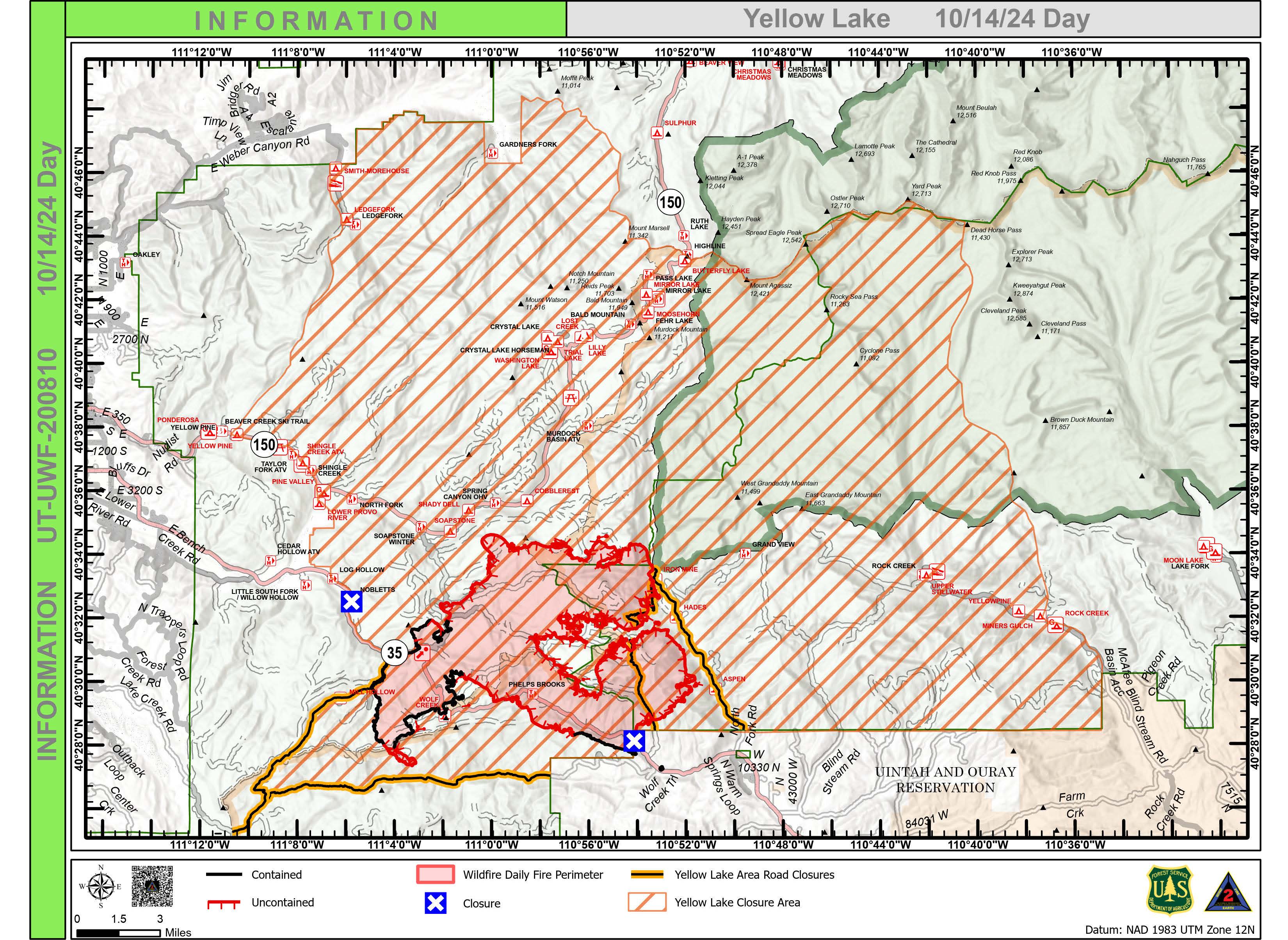
Yellow Lake Fire
Incident Update October 14, 2024
Size at time of update: 31007
Containment: 23%
Personnel: 814
Start: Saturday, September 28, 2024
Cause: Undetermined
Location: 10 miles southeast of Francis, Utah
A public meeting will be held at 6 p.m. this evening at the Tabiona School gymnasium to update conditions on the Yellow Lake Fire. It will be live-streamed on the Uinta-Wasatch-Cache and Ashley National Forest Facebook pages.
On Sunday afternoon, weather conditions increased fire behavior near Iron Mine Road as winds from the South hit exposed areas of jackpot fuels comprised of concentrated beetle kill timber. The fire has not reached Iron Mine Road. Quarter-mile spotting was observed but, the Soapstone Summer Homes near Mirror Lake Highway were not impacted. Air operations were heavily deployed as the fire moved into stands of mixed conifer and dense aspen. Dozers continue to tie in fire line between Iron Mine Road and Soapstone Road.
Fire activity on the east side also increased, eventually shading itself out. Firefighters are observing the re-ignition of dead and down timber in what is known as “re-burn potential.” Moderate torching of snags is being observed nightly.
Above normal temperatures will continue through Wednesday, resulting in the further drying of fuels. A notable change in the weather is expected Thursday bringing freezing temperatures and a greater chance of precipitation.
Patrol and structure protection continue in the North Fork of the Duchesne. Fireline between Rhodes Canyon and Lightning Ridge are being reinforced.
All evacuation orders and closures remain in effect.
Forest Closures:
- Updated October 11, 2024, a closure has been increased on the Uinta-Wasatch-Cache National Forest due to the Yellow Lake Fire. This Order shall remain in effect until October 31, 2024, unless rescinded.
https://www.fs.usda.gov/Internet/FSE_DOCUMENTS/fseprd1208350.pdf - Updated October 11, 2024, a closure has been increased on the Ashley National Forest due to the Yellow Lake Fire. This closure will remain in place through December 31, 2024, or until rescinded, for public safety.
Evacuation Areas: The North and West Forks of the Duchesne River, and Granddaddy Lakes area are under a mandatory GO evacuation meaning all residents, hunters, and recreationists must leave and stay out of the area. Hanna is under a SET order, advising residents to have bags packed and be prepared to evacuate if necessary.
For updated evacuation zones, please visit:
https://emergency-management-operations-wasatch.hub.arcgis.com/
https://tricountyemergencyalert.genasys.com/portal/en
https://www.fs.usda.gov/Internet/FSE_DOCUMENTS/fseprd1208878.pdf
Bingham Fire Daily Update for Monday October 14 2024 10 14 2024
Related Incident: Bingham Fire
Publication Type: News
Crews prepare for wintery weather; incident command shifts to local forest
Daily Update: October 14, 2024
Fire Information Phone: 503-854-3366 (8 a.m.-8 p.m.)
Email: 2024.Bingham@firenet.gov
Acres: 199 Containment: 94%
Location: Areas of the Mount Jefferson Wilderness, east of Marion Forks.
Start Date: September 30,2024 Personnel: 131
Resources: 2 crews | 1 water tender | 1 falling module| 1 excavator
Highlights: Firefighters continue to seek out isolated hot spots that could pose a threat to the fire perimeter, repair damage to the landscape caused by suppression activities, and haul equipment out of the forest ahead of wintery weather forecast for Tuesday night.
The Bingham Fire remained at 199 acres today, with containment bumping up to 94 percent.
Crews will have mild weather on the fire line today and Tuesday, with temperatures in the upper 50s to lower 60s. However, by Tuesday evening an 80 percent chance of rain is forecast, and temperatures are expected to plummet. Temperatures will hover in the mid-30s to lower 40s Wednesday through Friday, with waves of precipitation passing through all three days, including a chance of 3 to 6 inches of snow.
Management of the fire will transition back to the Detroit Ranger District’s type 4 incident management team at 6 p.m. today from California Incident Management Team 1. This will be the last update issued from the Bingham Fire unless significant changes warrant otherwise. Additional fire information can be obtained by contacting the Willamette National Forest at 503-854-3366.
Evacuations: The Linn County Sheriff’s Office has reduced the size of LEVEL 3: GO NOW! evacuation areas Oct. 10, converting them to LEVEL 2: GET SET evacuation alerts. The Level 2 evacuation area extends along Highway 22 to a ½-mile west of Highway 22, from Pamelia Road (NFS Road 2246) south to Parrish Lake Road (NFS Road 2266). Please refer to the Linn County Wildfire Map for more information: https://tinyurl.com/LinnCoFireMap. Highway 22 remains open.
The Willamette National Forest also reduced its closure area Oct. 10 within the same footprint as the county’s Level 3 evacuation zone. Details of the closure order can be found here: https://tinyurl.com/2y4sacl8. The Pacific Crest Trail through the Mount Jefferson Wilderness remains open. Impacted trails include Bingham Ridge Trail, Independence Rock Trail, Marion Lake Trail and Lake of the Woods Trail. With hunting season started, Forest Service staff will work with the Linn County Sheriff’s Office to reduce closure areas as soon as it is safe to do so.
Weather: Mild temperatures in the upper 50s to lower 60s are expected today and Tuesday, with wetter and cooler weather ushering in Tuesday evening. Highs in the mid-30s to lower 40s are forecast Wednesday through Friday, with bouts of rain and snow falling sporadically during that time.
Railroad Daly Fire Update 10 14 2024
Related Incident:
Publication Type: News
Type 3 Incident Command Team, Incident Commander Matt Young
Location: Bitterroot NF: Railroad Creek/ Skalkaho Creek confluence, 26 miles southeast of Hamilton
Beaverhead-Deerlodge NF: 20 Miles northwest of Georgetown Lake Dam off Skalkaho Hwy 38
Start Date: 7/25/2024
Cause: Undetermined
Daly Fire Acres: 10,205 Railroad Fire Acres: 1,496 Completion: 56%
Total Personnel: 258
Current Status
An overnight infrared flight showed increased acres from days prior. Crews continued burn out operations to the southwest towards Skalkaho Hwy 38. Dozer and handline continued on the Gird/Skalkaho ridge. Firefighters continued firing off the dozer line creating a wide blackline in efforts to slow fires progression. Multiple helicopters aided firefighters during firing operations. Crews persisted with felling operations to remove hazardous trees along Skalkaho Hy 38.
Today crews will continue chipping along the coal creek road. They will also continue constructing a 100’ shaded fuel break extending from the Hwy 38 corridor to Stoney Creek drainage ridgeline.
On the west side of the fire, crews will hold previous firing operations in the Buckhorn Saddle area as well as cutting hazardous trees along Skalkaho Hwy 38.
Weather and Fire Behavior
Continued high pressure will bring warm and dry conditions with daily winds. Relative humidity recoveries will continue to be poor through Wednesday. Warm and dry conditions are forecasted Monday and Tuesday.
After Wednesday cooler temperature's are expected with periods of precipitation and snow levels lowering to 4,000 feet. There is a 50% Probability for at least 2” of snow over mountain passes by Friday morning.
EVACUATIONS
On October 9, 2024 the Ravalli County Sheriff’s Office issued an Evacuation Warning for residents off of Skalkaho Highway (1700-2500 block) due to the Railroad-Daly Fire. For more information on evacuations visit the Ravalli County Sheriff Facebook page.
To register your phone number for emergency notifications in Ravalli County visit, http://hyper-reach.com/mtravallisignup.html.
CLOSURES
For additional information on the Skalkaho Hwy 38 road closure visit Montana Department of Transportation.
The Beaverhead-Deerlodge National Forest has issued an Area/Road/Trail Closure effective October 4, 2024.
The Bitterroot National Forest has also issued a road closure effective October 10, 2024.
These order’s are for public and firefighter safety during fire suppression efforts on the Fire.
Closure information and maps are posted on the Bitterroot and Beaverhead-Deerlodge National Forests’ website www.fs.usda.gov/alerts/bdnf/alerts-notices and www.fs.usda.gov/alerts/bitterroot/alerts-notices.
Elkhorn Fire Update 10 14 2024
Related Incident: Elkhorn Fire
Publication Type: News
Elkhorn Fire Update: 10/14/2024
Today, containment of the Elkhorn Fire remains at 75%. Firefighters will continue to work on identifying and tending to interior hot spots and suppression repair work.
We are asking the public to help prevent new fire starts by observing and understanding the Dakota Prairie Grasslands Emergency Fire Closure and Restriction. The full Closure can be found at the following link: https://www.fs.usda.gov/alerts/dpg/alerts-notices/?aid=91474.
Logan Fire Informational Meeting Yellow Pine ID on Oct 15 at 1200 PM 10 14 2024
Related Incident: Logan Fire
Publication Type: Announcement
Join members of the Great Basin Complex Incident Management Team and Payette National Forest agency officials for an informational meeting. The meeting will be held on Tuesday, October 15 at 12:00 P.M. at the Corner Pub in Yellow Pine, ID. Teams members and agency personnel will be available to answer questions and share updates.
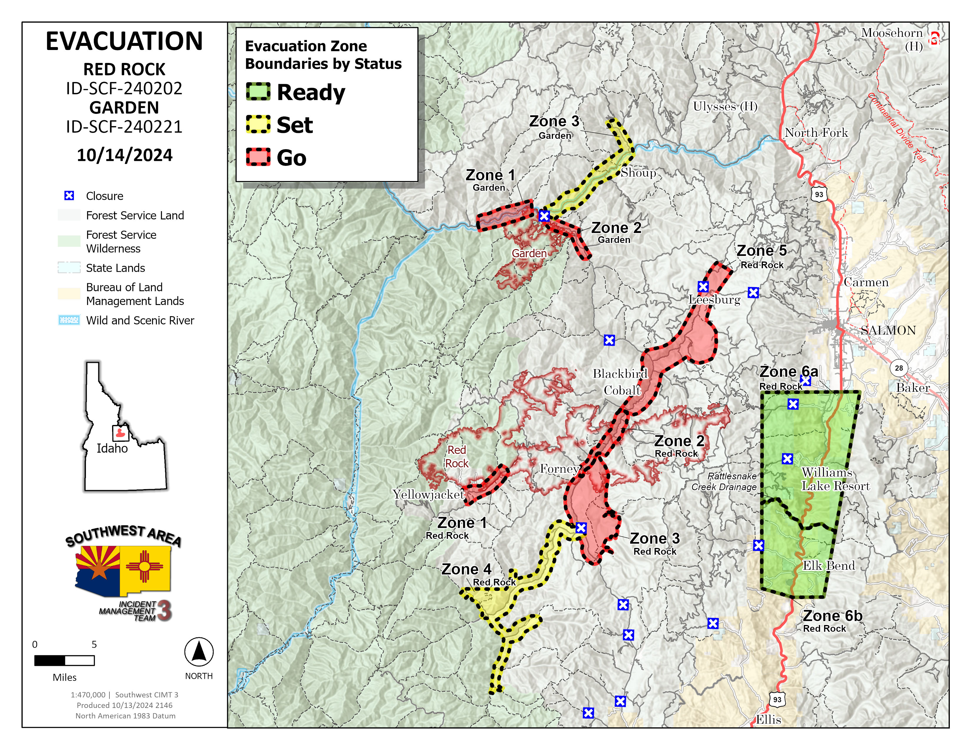
Garden and Red Rock Fires Update 10 14 2024
Related Incident:
Publication Type: News
Crews secure, hold, and patrol
Red Rock Fire
Operations: Yesterday crews made progress building handline south of the cobalt mine and removed vegetation along Blackbird Road (FR 115) and Deep Creek Road (FR 101) to be used as alternate containment line if needed. Unmanned aircraft assisted with interior ignitions to clean up pockets of unburned fuel and crews did ignitions off the Yellowjacket Road (FR 112) to keep the fire from progressing any further south. Dozers constructed line from Ridge Road (FR 020) to Moyer Peak with plans to continue until it connects to FR 103 in Moyer Creek. Containment line was connected around the entire spot fire near Napias Creek.
Today, preparing Blackbird Road and Deep Cr Road will continue with crews removing vegetation along the road. Dozer line construction will also continue on Moyer Peak. Along the Ridge Road (FR 020) crews are ready to start ignitions if needed to prevent fire spread to the east but will assess the need throughout the day. On the spot fire near Napias Creek, crews will remove snags and continue to secure the containment line.
Garden Fire
Operations: Yesterday fire behavior was minimal. Crews continued to patrol and mop up the perimeter in Panther Creek and the Salmon River corridor. Crews are methodically checking for heat sources. Today, monitoring these areas will continue and any hot spots identified will be extinguished.
Additional Information
Weather: There will be little change in the temperature and humidity Monday and Tuesday compared to yesterday, but winds are predicted to shift to the southwest sustained at 3-7 with gusts to 12 mph along the ridgetops and through the Clear Creek drainage.
Smoke: Learn about wildfire smoke and your health. A smoke outlook for the area is available.
Closures:
Salmon‐Challis National Forest has implemented a reduced Red Rock and Garden Fires Closure, Order Number: 04‐13‐24‐026. Please refer to the link below to see further information regarding the closure reduction.
The following roads are open. These roads border the closure.
- The Salmon River Road (#030) is open.
- The Panther/Morgan Creek Road (#055) is open from the junction with the Salmon River Road to Trapper Gulch.
- The Panther/Morgan Creek Road (#055) from the south is open to the junction of the Silver Creek Road (#108).
- The Silver Creek Road (#108) is open.
- The Opal Creek Road (#252) is open.
- The Iron Creek Road (#045) is open until the junction of the #046 road.
- The #046 road is open to the junction of the #047 road (Road to Sheephorn Lookout).
- The Leesburg Stage Road #002 road is open
- The Sharkey Creek Road #272 to Leesburg is open.
- The Jureano Mountain (#300) Road is open.
- The #325 road is open.
Safety: A Temporary Flight Restriction (TFR) is in place over the Red Rock and Garden fire areas, which includes uncrewed aircraft systems or drones. Reminder that if you fly we can’t, unauthorized drone flights pose serious risks to firefighter and public safety and the effectiveness of wildfire suppression operations.
Please stay out of the fire area. There is still active fire behavior in the fire area, including group torching and crown runs. There are multiple roads and bridges that have been destroyed or are impassable. Entry into evacuation zones that are in “Go” status is prohibited. The updated forest closure notice that encompasses both the Red Rock Fire and Garden Fire areas includes multiple road and area closures. Barricade closures will be posted at road intersections and forest boundaries.
Evacuations: For evacuation information in Lemhi County regarding both the Red Rock and Garden fires please go to: https://www.lemhicountyidaho.org/emergency-management-department.
Elk Fire Update 10 14 2024
Related Incident: Elk Fire 2024
Publication Type: News
Elk Fire Update – October 14, 2024
Rocky Mountain Area Complex Incident Management Team 3
Casey Cheesbrough, Incident Commander
Size: 89,315 acres (1,455-acre increase)
Total Personnel: 944
Containment: 27 percent
Cause: Lightning
Resources: 13 aircraft | 19 crews | 59 engines | 8 dozers | 18 water tenders | 5 masticators | 8 skidders | 6 feller bunchers 4 processor | 3 chippers
Key Messages: The Sheridan County Sheriff’s Office has implemented planned changes to evacuation levels today. Residents in the Poverty Flats area have been moved to “Go” status, while others to the north have been changed from “Ready” to “Set”. These changes are due to potential nearby strategic firing operations and increases of personnel, resources and equipment in these areas. For more information on Sheridan County evacuations, go to the Sheridan County Emergency Management website: tinyurl.com/2s38bcc5.
Public information officers will be at the Big Horn post office today from 2:30 pm to 4:30 pm to answer questions about the current fire situation, operational strategies, and evacuations.
Current Situation: Firefighting crews continued strategic firing operations south of the main fire yesterday to reduce fuels, slow the fires spread, and reduce intensity. Firefighters started ignitions at Red Grade Road and the operations progressed to the north. Overnight crews continued the firing operations and were able to complete firing along the seven-mile-long control line. Structure protection crews will continue work near homes and other properties in the Poverty Flats area today, clearing flammable debris and setting up ponds, pumps and sprinkler systems.
Up Red Grade Road on the National Forest, crews are using feller bunchers, masticators and other heavy equipment to clear vegetation on both sides of the FSR 26 in order to create defensible line for strategic firing operations, if needed, to stop the southward movement of the fire.
In the Burgess Junction area, hand crews and heavy equipment will continue work to improve the 15 Road and remove trees and vegetation. Their goal is to reduce potential fire impacts in Burgess Junction. Crews and equipment will move to the 16 Road today, doing similar work.
Crews north of the fire continued chipping debris along the 144 road, as well as patrolling along the dozer lines to prevent any movement west into the Broderick Flats. Patrols along containment line on the eastern side of the fire are ongoing, with very few hotspots being found.
Weather & Fire Behavior: Yesterday there were moderate temperatures, slightly lower relative humidity, and lingering smoke. This resulted in minimal fire activity during the day. Last night, the lower humidity continued early resulting in more fire activity than recent nights. After midnight, temperatures fell and humidity rose resulting in steadily decreasing fire activity. Today is forecasted to be warmer and drier with a westerly wind moving to a northwesterly wind. This will likely increase fire activity on the southern end of the fire; for air-quality and smoke information, go to airnow.gov.
Evacuations and Closures: For information on Johnson County evacuations, go to Johnson County Emergency Management’s Facebook page: facebook.com/JohnsonCoWYEMC. For info on Sheridan County evacuations and road closures, go to the Sheridan County Emergency Management website: tinyurl.com/2s38bcc5. You can also call the Sheridan County Sheriff’s Office (307-672-3455) or Sheridan County Emergency Management (307-752-2174). The Red Cross has an evacuation center at the Sheridan County Fairgrounds that can accommodate people, RVs/campers, pets, and livestock. Call 307-752-2174 or 307-683-6965 to make arrangements. US Highway 14 is closed at Granite Pass/Hunt Mountain Road/FS 10 (milepost 38.3). US Highway 14A is closed at Hunt Mountain Road/FS10 (milepost 85.6). View the Wyoming Department of Transportation road-closure map here: wyoroad.info. Bighorn National Forest lands around the Elk Fire are closed under Order 02-02-06-24-08. The order and map can be viewed here: fs.usda.gov/alerts/bighorn/alerts-notices.
Line Fire Daily Update for 10 14 2024
Related Incident: Line Fire
Publication Type: News
Location: San Bernardino County, CA Start Date: September 5, 2024
Size: 43,978 acres Percent Contained: 97%
Cause: Human Personnel: 510
CURRENT SITUATION:
Heat is diminishing near the confluence of Bear Creek and Siberia Creek thanks to the successful efforts of helitack crews in the steep, resistant terrain. Patrols near Mile Creek and Cold Creek are reporting minimal heat in the area, with little threat to control lines. Fuels are drier than normal for this time of year and receptive to ignition, so firefighters are staying engaged and are prepared for initial attack response if needed. Fire danger remains high. The public is asked to be extremely diligent and fire wise.
Considerable progress has been made with suppression repair on the Line Fire. The goal of this plan is to repair the land, water, and property impacts created by incident suppression activities, returning the area to a more natural condition by rehabilitating impacted areas to the extent practical. The overall goal with suppression repair is to avoid concentration of water runoff onto the fire line and allow for proper drainage of water across slopes. To date, over 79 miles of dozer line have been repaired and 35 miles are in various stages of assessment or repair. Over 22 miles of handline have been repaired, and six miles are in progress.
This will be the final written daily update for the Line Fire. Additional updates regarding the fire will be posted to social media.
WEATHER:
Light winds and clear skies will continue through at least Tuesday. Additional moisture will result in moderate to good relative humidity through the day Thursday. Temperatures will fluctuate a few degrees but top out mainly in the 60s and 70s before cooling down even more on Thursday.
CLOSURES:
San Bernardino National Forest has issued closures for areas surrounding the Line Fire. For more information and to see the map use this link - https://www.fs.usda.gov/detail/sbnf/?cid=FSEPRD1181411.
Highway 330 remains closed from Highland Avenue to Highway 18 as CalTrans performs repairs to the road and guardrails.
EVACUATIONS:
There are currently no evacuation warnings or orders for communities in or around the Line Fire.
La Jara Unit Monitoring and Mopup 10 14 2024
Related Incident:
Publication Type: News
Taos, N.M., Oct. 13, 2024—Here’s the latest for prescribed fires on the Carson National Forest:
- It’s the last day of major operations on the La Jara Prescribed Fire. After today fire crews implement the long-term patrol and monitoring plan for the La Jara Unit to ensure that all hot spots burn out in a timely manner or are mopped up. Crews along the fire perimeter especially near highway 64 are making the fire safer and reducing residual smoke by extinguishing or removing burning material along or near the control line, felling snags, and moving logs so they won't roll downhill. Throughout the last few days, an uncrewed aerial system, or drone, has been used to both help identify hot spots throughout the project area and to identify burned areas that no longer carry heat.
- In recent years, the Carson National Forest has increased our post-ignition monitoring efforts for prescribed fires to ensure the safest outcomes. Use of drones and lengthier waiting periods before officially calling a fire “out” are examples of these efforts. To learn more about how the Carson is improving our prescribed fires, visit this page: (https://www.fs.usda.gov/detail/carson/fire/?cid=fseprd1205804)
- Resources are being gathered to implement the Powderhouse Prescribed Fire in the Valle Vidal as early as Oct. 15. For more details read the October 10 news release available at www.fs.usda.gov/detail/carson/news-event
Shoe Fire Daily Update for 10 13 2024
Related Incident: Shoe Fire
Publication Type: News
Email: 2024.shoe@firenet.gov
Incident Website:
https://inciweb.wildfire.gov/incident-information/cashf-shoe-fire
Forest Website:
Location: Shasta County, CA
Start Date: Wednesday, October 9, 2024, at 6:57 p.m.
Cause: Human caused
Size:2,861 acres
Percent Contained: 0%
Vegetation: Timber, Chapparal
Number of Personnel Assigned: 421
Complex California Interagency Incident Management Team 13 has taken command of the fire as of 7:00 a.m., October 12, 2024.
With new fire growth in the Beartrap creek, crews and aircraft will prioritize suppression efforts for the remainder of the day implementing full suppression tactics. Ground crews continue to do hose lays, structure protection and dozer operations to further establish control lines. Tactical firing operations have been initiated to help protect structures and have been reported successful by fire personnel. As suppression tactics continue the safety of firefighters, and the public will remain our highest priority.
Fire is predominantly moving northward, fueled by timber in steep and rugged terrain. A warming and drying trend will begin today extending until Monday as humidity levels gradually begin to decrease in the area. We expect a slow increase in fire behavior carried by upslope and up canyon winds.
Additionally, the Shoe fire was named after Shoeinhorse Mountain which is in close proximity to this incident.
WEATHER: The forecast for the area indicates a warming trend over the next few days with increased winds.
EVACUATIONS: Mandatory evacuations remain in place for zone LKH-1448-B. Residents who have not evacuated are encouraged to do so. Evacuation information and alerts can be found by visiting protect.genasys.com
ROAD CLOSURES:
- Fenders Ferry Road at Pit River 7 Bridge: West-Bound Fenders Ferry Road (Also known as 34N17 - Forest Service Road 27) at the Pit River Bridge/Pit 7
- Ferry Road is closed at McCloud Bridge: East-Bound Fenders Ferry Road at the McCloud River Bridge
Information staff for the Shoe Fire are working diligently to provide timely and accurate information to the public. Fire updates can be found on the Shoe Fire 2024 Facebook page: www.facebook.com/2024ShoeFire/