
Incident Publication
Forest Service Teams Begin PostFire Assessment of Boise National Forest Wildfires 10 05 2024
Related Incident: Boise NF Post-Fire BAER 2024
Publication Type: News
Forest Service Teams Begin Post-Fire Assessment of Boise National Forest Wildfires
Three Forest Service Burned Area Emergency Response (BAER) teams have been established by the Boise national forest (NF) to begin post-fire burned area assessments of the 1) Lava-Boulder-Wolf Creek, 2) Goat-Snag-Dollar, and 3) Nellie-Bulldog-Flat fires that recently burned on National Forest System (NFS), state, and private lands. Forest Service BAER team assessments typically take approximately two weeks to complete.
BAER teams coordinate with the Natural Resources Conservation Service (NRCS), National Weather Service (NWS), U.S. Geological Survey (USGS), Bureau of Land Management (BLM), and other federal, tribal, state, counties, and other local agencies as they assess potential post-fire impacts to the burned watersheds.
Emergency Stabilization-BAER surveys are rapid assessments to identify imminent post-wildfire threats to human life and safety, property, and critical natural or cultural resources on NFS lands. The BAER team evaluates the burned area to identify watersheds having increased potential for post-fire flooding, sediment delivery, and rockslides, and assists land managers in preparing for seasonal thunder cell storms or winter rainstorms. They also model hydrologic response throughout the burned area and share the team’s findings with the affected downstream agencies.
BAER teams may consist of scientists and specialists including hydrologists, geologists, soil scientists, road engineers, botanists, biologists, archeologists, and geographic information specialists. BAER teams collect field data during their burned area surveys to analyze through GIS and computer models and present their findings along with recommended BAER emergency stabilization treatments in a BAER assessment report.
The BAER teams develop soil burn severity maps for each wildfire utilizing satellite imagery and specialist field-gathered data to analyze fire effects, produce erosion potential and debris-flow maps, and model post-fire flows. This is the first step in assessing potential watershed impacts from wildfires to any federal values that may be at-risk from potential increased flooding, sedimentation, debris flows, mudflows, and rockslides. BAER teams produce a report that describes potential threats associated with the burned area’s post-fire conditions and sometimes include recommended emergency stabilization measures and actions. BAER emergency response efforts are focused on the protection of human life, safety, and property, as well as critical cultural and natural resource values such as the water quality of streams and wetlands on federal lands.
BAER reports are shared with interagency cooperators such as Idaho Office of Emergency Management, NRCS, and the affected counties who work with downstream private homeowners and landowners to prepare for potential post-fire flooding and debris flow impacts. BAER teams coordinate with the local Forest Service units during the assessment of the burned area to ensure post-fire threats are identified for NFS critical values that could be at-risk.
Homes or businesses that could be impacted by flooding from federal land that result from wildfires may be eligible for flood insurance coverage from the National Flood Insurance Program (NFIP). Information about NFIP is available through FEMA at www.fema.gov/national-flood-insurance-program, or www.floodsmart.gov/wildfires. Other flood preparedness information is available at www.ready.gov/floods at www.floodsmart.gov/.
Additional information on understanding the BAER program, process and other post-fire information is posted on the “Boise NF Post-Fire BAER 2024” InciWeb page found at: Idbof Boise Nf Postfire Baer 2024 Information | InciWeb (wildfire.gov).
BAER SAFETY MESSAGE: Everyone near and downstream from the burned areas should remain alert and stay updated on weather conditions that may result in heavy rains and increased water runoff. Flash flooding may occur quickly during heavy rain events--be prepared to act. Current weather and emergency notifications can be found at the National Weather Service website: www.weather.gov/boi/.
###
BinghamFireUpdateforSaturdayOctober5 2024 10 05 2024
Related Incident: Bingham Fire
Publication Type: News
Marcel Potvin, Incident Commander
Start date: Sept. 30, 2024
Location: Detroit Ranger District, Willamette National Forest
Cause: Undetermined
Fire size: 183 acres
Full Suppression
Personnel: 204, including 8Crews, 7 Engines, 2 Dozers
The Bingham Fire, located east of the Bingham Ridge Trailhead near Marion Forks, was reported on the evening of Sept. 30, 2024. The fire is burning partially within an older fire scar along the Bingham Ridge Trail that extends into the Mount Jefferson Wilderness area. Complex Incident Management Team (CIMT) California Team 1 will arrive today for an in brief.
LEVEL 3: GO NOW! Evacuation Alerts have been issued by the Linn County Sheriff’s Office for a large area of the Mount Jefferson Wilderness. Additionally, LEVEL 2: GET SET Evacuation Alerts have been issued for the area around Marion Forks Campground, and Marion Forks Fish Hatchery. The Level 2 evacuation area also extends along Highway 22, to ½-mile west of Highway 22, from Pamelia Road (NFS Road 2246) south to Parrish Lake Road (NFS Road 2266). Please refer to the Linn County Wildfire Map for more information: https://tinyurl.com/LinnCoFireMap. Highway 22 remains open at this time.
The Willamette National Forest issued an updated formal closure yesterday in the same footprint of the Level 3 Evacuation here: https://tinyurl.com/26jpr9a6. A large evacuation area like this is necessary to give wildfire response teams enough space to safely travel to and fight the fire, as crews will be on road systems, trails, and air assets may be utilizing nearby water sources. The fire itself is much smaller than the evacuation area. The Pacific Crest Trail (PCT) through the Mount Jefferson Wilderness is expected to remain open. The trails and roads west of the highway are closed from Pamelia to Big Meadows Loop/Turpentine Loop area. Hunting season will be opening today, and the forest will work with Linn County Sheriff to reduce closure areas as soon as it is safe to do so.
Firefighters are working as direct as possible to the fire’s edge. In the last four days, crews have been working to complete initial primary line construction on the southern side of the fire to the wilderness boundary. Contingency lines have gathered equipment and may be starting construction soon. There is a plan being developed for protecting structures around Marion Forks and Independence Prairie.
WEATHER: Yesterday’s rain was about 0.3 inches of precipitation over the fire. Light easterly winds are forecasted for the fire area through today, temperatures reaching high 60’s with high pressure remaining Sunday. Smoke may be visible from Detroit, Idanha, and along Highway 22 today.
SAFETY: Members of the public are encouraged to heed local evacuation orders issued by the county sheriff’s office and emergency notification systems. Know the Ready, Set, Go levels and make appropriate preparations. READY your belongings; SET your things at the door or prepack them in your car; GO and leave immediately.
Linn County Resources
Fire Evacuation & Status Live Updates: https://www.linnsheriff.org/wildfire_live_updates/
Wildfire Preparedness & Resources: https://www.linnsheriff.org/wildfire-recovery/
Willamette NF Resources
Detroit Ranger District Front Desk: 503-854-3366
https://www.facebook.com/willamettenf
https://www.fs.usda.gov/main/willamette/
Bingham Fire Information
Email: 2024.bingham@firenet.gov
Inciweb: https://inciweb.wildfire.gov/incident-information/orwif-bingham-fire
Fish Creek and Pack Trail Daily Update October 5 2024 10 05 2024
Related Incident:
Publication Type: News
Overnight the Pack Trail Fire and Fish Creek Fires merged along Bull Creek.
The incident will now be managed under one name, the Pack Trail Fire.
Pack Trail Fire Phone: 307-395-2351
Total Acres: 48,640 Email: 2024.fishcreek@firenet.gov
Total Personnel: 444
Contained/Completed: This number is being recalculated due to the merger of the two fires.
Weather - The Red Flag Warning issued yesterday remains in effect through 9:00 p.m. tonight. Wind gusts could exceed 50 mph. Overnight winds were measured at 46mph on the ridgetops and 24 in the valleys. Wind is expected to taper off at 9:00 this morning but will remain in the 30mph range on the ridges. Low humidities, warmer temperatures, and strong, gusty winds remain in play and will continue to influence fire behavior. Winds are expected to shift from the west today which could bring certain parts of the fire into alignment with terrain. Residents and travelers are urged to monitor fire and emergency management announcements closely.
Operations - The Fish Creek fire’s footprint experienced some expansion on the south side overnight, coming down to meet the Pack Trail fire along Bull Creek. On the Pack Trail footprint there was some movement down off the rim of the Lava Mountain escarpment, but it remains above the 540 road as of this morning. On the south side it continued to burn into the Purdy and Lava Mountain burn scars with the most growth from Hackamore Creek to along the north side of Coyote Creek.
Firefighters continued work on the shaded fuel break up the 540 road and are nearing a meeting with crews coming down from the north near Pellham Lake. Structure protection has completed preparations on the US-26 corridor and continue work up towards Pinnacle and Brooks Lake. Hotshot crews in Trout Creek area have started fire line construction between the Lava Mountain and the Purdy fire burn scars, taking advantage of terrain and an existing road.
Safety - Drivers on US-26 may experience periods of smoke today due to high winds. Please use caution while driving, use headlights, and expect to encounter fire vehicles along the road. If planning travel on US-26 across the Continental Divide monitor WY-DOT for possible closures dur to fire activity.
Teton Interagency Fire managers are maintaining the Very High Fire Danger Rating for Grand Teton National Park, the Bridger-Teton National Forest, and the National Elk Refuge. This means fires can start easily from most causes and may spread rapidly, becoming large fires and exhibiting extreme fire intensity, Residents and visitors are urged to exercise extreme caution with fire or possible ignition sources, including campfires.
Forest Closures - Closure Order #04-03-24-314 is in effect from October 1 through October 15, 2024 at 6:00 a.m. unless rescinded. This order supersedes previous orders, including #04-03-24-313, prohibiting the same or similar acts in the same described area. Click here to access the closure order and map on InciWeb.
Evacuations - Evacuations and evacuation alerts for several subdivisions and ranches in Fremont County, WY remain in place. See the Fremont County Emergency Management Facebook Page for alerts and current status.
Facebook: USDA Forest Service - Bridger-Teton National Forest, USDA Forest Service - Shoshone National Forest
Pack Trail Inciweb: https://inciweb.wildfire.gov/incident-information/wybtf-pack-trail-fire
Fish Creek Inciweb: https://inciweb.wildfire.gov/incident-information/wybtf-fish-creek-fire
Red Rock and Black Eagle Fire Daily Update 10 05 2024
Related Incident:
Publication Type: News
FIRE ACTIVITY:
Both the Red Rock and Black Eagle Fires experienced extreme fire behavior with subsequent massive fire growth to the northeast. With wind gusts estimated in excess of 60 mph, the two fires have merged and are at a combined size of an estimated 50,000 acres.
Lemhi County Sherrif’s Office issued several evacuation notices and assisted with evacuations ahead of the fire for the areas of Panther Creek, Forney, Moyer, Cobalt, Blackbird, and Leesburg. Damage to any structures in these areas is still being assessed. Areas along the US-93 corridor between Elk Bend and Salmon were also placed in a “Ready” status as the eastern edge of the fire has made it roughly two-thirds of the way to Highway 93.
All divisions of the fire are eager to reenage where safe to do so and reasses which containment lines are still valid after yesterday’s wind event.
Please stay out of the area. There are multiple roads and bridges that have been destroyed or are impassable. An updated list of road and area closures will be posted as soon as possible. Furthermore, the forest closure notice will most likely be expanded and include additional road, trail, and area closures.
WEATHER:
High pressure builds into the area behind yesterday’s system and will bring cooler temperatures and lighter westerly winds. The high pressure will remain over the area through the weekend resulting in seasonable temperatures and moderate humidity readings near 20% in the afternoon. Winds should remain light with no precipitation forecasted for the next 5 days.
FIRE BEHAVIOR:
Fire behavior will moderate after the frontal passage yesterday with decent humidity recoveries and lighter winds. Fuels are still available with heavy dead and down components and remain most problematic for firefighters. Areas where humidities fall below 25% with gusty afternoon winds can experience increased activity, including short-range spotting. Opportunities to attack the fire directly will likely be confined to morning hours and when effective water support is available. Fire will continue to grow with wind and up slopes/drainages.
FOREST CLOSURES: For forest closure information please go to: https://www.fs.usda.gov/alerts/scnf/alerts-notices
EVACUATIONS: For evacuation information in Lemhi County regarding these fires please go to: Emergency Management Department | Lemhi County, ID (lemhicountyidaho.org).
Line Fire Fact Sheet 10 05 2024
Related Incident: Line Fire
Publication Type: News
Today at 1:00 pm there will be a Public Meeting at the Big Bear Performing Arts Center. The agenda includes Line Fire updates, burned area emergency stabilization efforts, and updates from Cal Trans. The address is 39707 Big Bear Blvd, Big Bear Lake, CA. It will also be live streamed on the San Bernardino National Forest Facebook page.
Crews continued to hold the Line Fire close to its current footprint, with minimal growth since yesterday. Around the fire perimeter where it has been contained, crews monitored and patrolled the lines with no issues or challenges. Where the fire line is still active, crews worked hard to improve and hold the lines, again with no issues or challenges. In the northeast corner of the fire, sawyer crews focused on removing hazardous trees which allowed safer access for firefighters allowing them to mop up deeper into the fire area.
Yesterday, San Bernardino County Sheriff’s Department lifted the remaining evacuation warnings for the city of Big Bear Lake and they downgraded Angelus Oaks to “Evacuation Warning” status. Highway 38 is now open to Angelus Oaks from the west, but it remains closed due to firefighter operations beyond Angelus Oaks to Lake Williams Drive, five miles east of Big Bear Lake. **Correction: The Seven Oaks area remains under an Evacuation Order**.
Today, most crews will continue patrolling, monitoring and strengthening lines. Additional crews will transition to repairing areas impacted by suppression activities. Conditions remain very dry and all crews will remain vigilant for any new or increased fire activity.
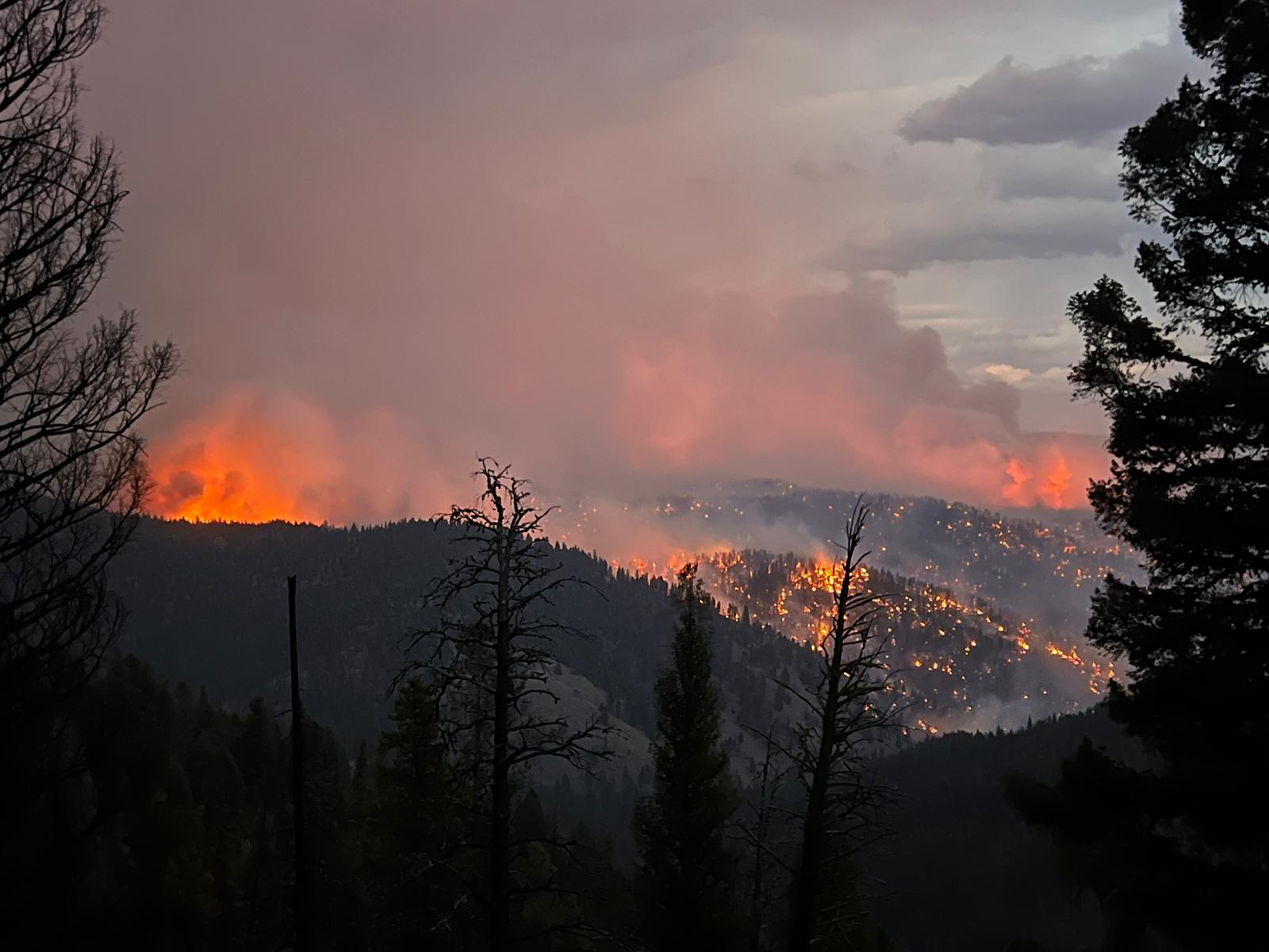
Middle Fork Complex Daily Update Oct 5th 2024 10 05 2024
Related Incident:
Publication Type: News
Middle Fork Complex Fire Update
October 5, 2024
Middle Fork Fire Information: 208-992-3045 (8 a.m. – 8 p.m.) | Email: 2024.middleforkcomplex@firenet.gov
Middle Fork Complex: 61,490 acres, 90% completion, 199 Personnel
Snag Fire: 33,435 acres, 90% completion, 63 Personnel
Goat Fire: 28,557 acres, 41% completion, 111 personnel
Firefighters worked late into the night managing the Goat Fire, which made a significant advance in the northeast corner of Valley County, south of Stolle Valley due to strong, gusty winds during the day. The edge of the fire moved over a mile to the northeast and is now near the Yellow Jacket Creek Trail Bridge.
Firefighters in the area are continuing to focus on protecting bridges and other important structures from the fire which is being fueled by dry grass, brush, and downed trees in an area that burned in 2007. Conditions are expected to improve as the dry cold front moves into the area bringing a wind shift that could help push the fire back on itself. They are also working on contingency and control lines to keep the fire from further impacting the residents in the Warm Lake area.
Fire activity in the rest of the Snag and Middle Fork Complex areas is still mostly smoldering and creeping, and suppression repair work continues in these areas.
The Valley County Sheriff’s Office has issued a "Ready Evacuation” notice for the Warm Lake area due to the Goat Fire's movement. The fire has worked its way around the Silver Creek Lookout, but so far, there are no reports of damage to any structures there.
Valley County residents are encouraged to sign up for Code Red Emergency Alerts to stay informed. For any questions or updates on evacuation readiness, please contact the Valley County dispatch center at 208-382-5160. Currently, the Warm Lake Road remains open for travel without restrictions.
Boise National Forest closures remain in effect and the road closure on the Middle Fork Road remains in place. Visit the Middle Fork Complex Fire Facebook page for a detailed description of where that road closure is. Additional closure information is available at this link: https://www.fs.usda.gov/alerts/boise/alerts-notices.
Air support was limited yesterday due to a new fire near Boise that immediately threatened homes, along with a smaller fire in Valley County called the Bummer Fire.
###
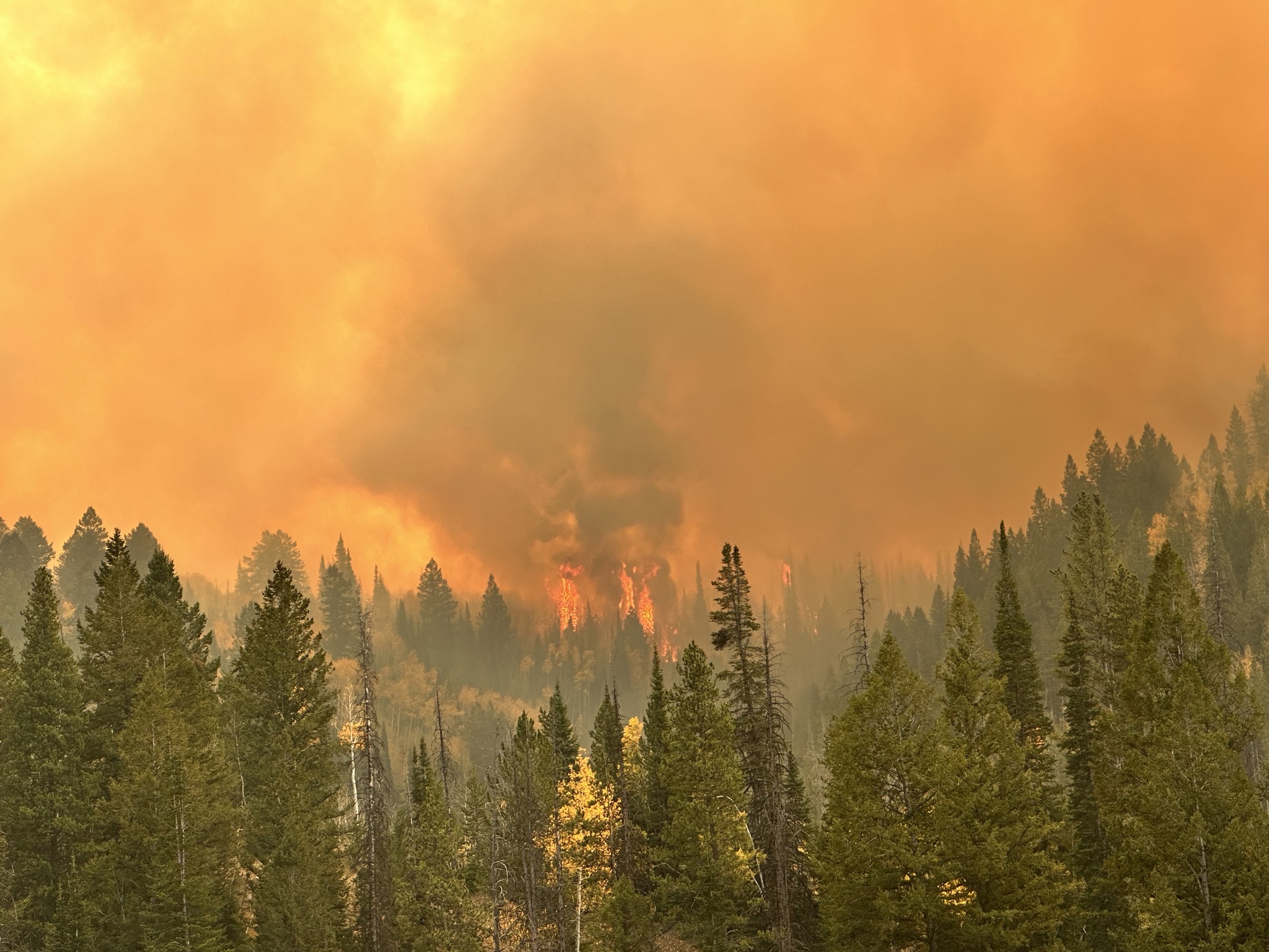
Yellow Lake Fire Update 10 05 2024
Related Incident: Yellow Lake Fire
Publication Type: News
Note: Infrared Flight occurred late, and maps are delayed. They will be added later
October 5, 2024— Yesterday was a particularly challenging day, with red flag conditions that are prime for fire growth—high winds, record-breaking temperatures, extremely low humidity, and unseasonably dry weather. Despite these tough conditions, firefighters worked diligently to reduce the fire’s impact where possible, but the primary focus remained on ensuring the safety of fire personnel and the public. Everyone safely exited the field by the end of the day, which will always be the top priority.
During the predicted wind event, multiple wind-driven spot fires ignited north of Highway 35 and the pipeline, establishing in timber and producing more visible smoke. The fire took advantage of available fuels and favorable winds, causing it to spot and burn in pulses. This led to its spread toward Soapstone Pass and east toward Rhodes Canyon. The fire is now burning south and parallel to Highway 150 (Mirror Lake Highway), though it is not currently impacting that area. The estimated acreage is now 7,798, though this will continue to adjust with updated infrared mapping.
Today’s forecast brings another day of strong winds and shifting directions. Crews will continue their full suppression efforts, focusing on minimizing fire movement into the West Fork of the Duchesne drainage, north into Soapstone Basin, west toward Mill Hollow ,and East towards the North Fork of the Duchesne. They are also working to protect structures and other values. While the fire may continue to grow, crews will prioritize holding the anchor point and keeping the fire in a manageable area where suppression efforts can be most effective.
As of last night, the YMCA camp and ranger station remain safe, with structure protection measures in place, including sprinklers and hose-lays for added defense. Piuta Girls Camps and recreation structures within the closure area were treated with retardant.
A forest closure is now in effect for both the portions of the Uinta-Wasatch-Cache and Ashley National Forests affected by the fire. Yesterday demonstrated how quickly the fire can spot over long distances and spread rapidly in the heavy timber, aided by strong winds and dry conditions. With another red flag warning in effect, forest managers are taking a conservative approach to ensure public and firefighter safety amid the unpredictable weather and unseasonably dangerous conditions.
The fire has been determined to be human-caused and remains under investigation. Further information will be provided once the final investigation report is completed.
The Yellow Lake Fire is burning east of Mill Hollow Reservoir on the Uinta-Wasatch-Cache National Forest, with 423 personnel currently assigned to the incident.
Rail Ridge Update 10 05 2024
Related Incident:
Publication Type: News
Central Oregon Wildfire Information: centraloregonfire.org
Email: 2024.railridge@firenet.gov – Phone: 541-208-7111
Social Media, Evacuation and Closure Information: https://linktr.ee/RailRidgeFire
Acres: 168,002 – Containment: 89% – Detection: 09/02/24 – Cause: Lightning – Personnel: 601
Forest closures around the Rail Ridge and Crazy Creek Fires remain in place. A map with the ODFW hunting management unit areas overlaid with the closure area and fire footprint can be found at: https://linktr.ee/RailRidgeFire. For the safety of firefighters and forest visitors it is of the utmost importance that the closure areas remain in place at this time. Potential hazardous circumstances associated with the area include hazard trees and ground stability in recently burned areas, continued burning within the interior of the fire, firefighters and apparatus traveling and working in the area and there is no means to quickly notify public in the fire area of emerging safety concerns.
Operational Update
Yesterday, the passing cold front brought high winds across the fire area which tested the established containment lines. No significant growth was reported, and current containment lines held. Interior pockets of fuels did become active during the afternoon, and the westerly side of the fire in the Black Canyon Wilderness continued burning through the Honeymoon Creek area. Tactical firing operations were completed to prevent fire from advancing toward Wolf Mountain Lookout and the communication site. Early in the day a smoke column west of the Rail Ridge Fire was reported. Local resources responded and found and unburned island of fuel within the Crazy Creek Fire footprint to be burning and was suppressed quickly.
Last night’s relative humidity recovery is a welcome start to the weekend for firefighters. Coupled with predicted lighter winds, fire activity is expected to be minimal. Interior flare-ups and additional acres of burning in the Black Canyon Wilderness area will continue to produce smoke. Firefighters will continue to strengthen contingency control lines and containment around the Black Canyon Wilderness. As needed, tactical firing operations will be used to add depth to lines that are already in place. Suppression repairs are ongoing with resource advisors, and mop-up and patrolling will continue around the contained portions of the fire.
Weather
Terrain driven winds around 10mph are expected over the fire area with mostly sunny conditions and temperatures in the mid to upper 60’s. Relative humidity will again recover tonight to an estimated 75-80% but will dip into the 20-25% range in the afternoon today.
Evacuations
Level 1 evacuations in Grant County were dropped this week and the level 2 evacuations remain. Wheeler County evacuation remain the same.
For Current Evacuation Levels all affected counties, please visit: https://linktr.ee/RailRidgeFire
Closures
The U.S. Forest Service and Bureau of Land Management have implemented closures for the Rail Ridge Fire. For more details and closure maps, visit https://linktr.ee/RailRidgeFire
HomesteadDiamond Complexes Daily Fire Update 10 05 2024
Related Incident: Lane 1 Fire
Publication Type: News
Homestead/Diamond Complexes Fire Update
Oct. 5, 2024
Fire Information: 541-208-7100, 8 AM - 8 PM
InciWeb-Homestead: https://t.ly/syeHa and InciWeb-Diamond: https://bit.ly/4gCfLsp
Six fires within the Homestead and Diamond Complexes remain under active management by Northwest Team 12. Firefighting resources from the Homestead/Diamond Complexes remain available for initial attack response to new fire starts in the area as needed.
The Oregon Department of Transportation temporarily lowered the speed limit on Hwy 138 in front of the Fire Incident Command Post just east of Glide to 45 MPH for the safety of firefighters and community residents.
Homestead Complex: 10,500 acres, 35% contained │ Diamond Complex: 11,141 acres, 90% contained │ Total personnel: 353
Anticipated precipitation failed to materialize across the fire area yesterday, although cooler temperatures and moisture helped to subdue fire behavior through mid-day. In the afternoon, fire activity picked up again on multiple fires, prompting firefighters and aircraft to engage.
On the Horse Heaven Fire, previously active fire areas were relatively quiet yesterday. Firefighters are successfully keeping the fire on the east side of Horse Heaven Creek. Grading continues along Forest Service Roads (FSRs) 3831 and 2213 and heavy equipment continues to break down dozer berms along FSR 5850. Crews are completing hand line repair and will begin seeding and spreading straw over repaired fire control lines to help prevent erosion.
The Fuller Lake Fire was active again with isolated tree torching and backing fire within the Boulder Creek Wilderness. Firefighters on patrol located and secured a spot fire across FSR 3810 on the east side of the fire. Today, crews will continue to patrol and secure any spot fires that emerge. Sawyers continue to assess and mitigate fire-weakened trees along roads. Road work is ongoing on the Bullpup Fire along FSR 200 and chipping continues along FSRs 3816 and 300.
Engine crews patrolling the No Man Fire yesterday discovered a flare up along the south side of the fire. A heavy helicopter dropped approximately 22,000 gallons of water to cool the flames. Helicopters will remain available today to assist if activity picks up again. Firefighters will also be working on opening up firelines on the south end to keep the fire contained.
Two fires remain uncontained on the Diamond Complex. On the Potter Fire, road graders continue to make progress at the pace of approximately two-three miles per day working along FSR 3703. The Pine Bench Fire continues to show no visible smoke.
Closures: The Umpqua National Forest revised the fire closure area yesterday. The updated Umpqua National Forest closure and map can be found at https://tinyurl.com/bmtfvvz6. The BLM Roseburg District closure order also remains in place https://t.ly/uWX6l. A Temporary Flight Restriction remains in effect https://bit.ly/3XJL0cD.
Weather: There will be a warming and drying trend through Tuesday as a ridge of high pressure builds over the region. Temperatures will be above normal, with 73-78 degrees forecasted in the valleys today.