
Incident Publication
Middle Fork Complex Daily Update Oct 4th 2024 10 04 2024
Related Incident:
Publication Type: News
Middle Fork Complex Fire Update
October 4, 2024
Middle Fork Fire Information: 208-992-3045 (8 a.m. – 8 p.m.) | Email: 2024.middleforkcomplex@firenet.gov
Middle Fork Complex: 61,490 acres, 90% completion, 269 Personnel
Snag Fire: 33,435 acres, 90% completion, 49 Personnel
Goat Fire: 28,037 acres, 41% completion, 108 personnel
Weather Outlook: A red flag warning has been issued for the area around the Middle Fork Complex for Friday, October 4. Relative humidity levels are expected to dip down to the mid to upper teens. Southwest winds of 15-20 mile per hour are likely and gusts to over 30 mph possible as another dry cold front passes. Increased fire activity is expected on the Goat Fire and other fires in the area may also show increased fire activity. An increased amount of smoke from the fire areas will likely be visible.
Goat: Fire behavior is mainly flanking and backing with some isolated torching. Some short duration runs and short-range spotting did occur. Goat Fire still has several areas of intense heat along the southeast and northeast perimeter. These areas are mostly steep, difficult to reach terrain. An increase in surface spread is likely as the winds increase and low relativity humidity continues. Crews are continuing suppression and contingency work to prevent fire spread to the south and are being supported by aircraft and heavy equipment.
Middle Fork Complex: Fire behavior continues to be minimal smoldering and creeping with no intense or scattered heat near the perimeter. There is potential for some areas that still hold heat to become more active with the incoming weather conditions. Some isolated interior torching is also possible. Crews will continue suppression repair work and contingency line work in the area. We do not expect to see significant perimeter growth on these fires.
Snag: Fire behavior continues to be minimal smoldering and creeping. There was some heat detected on the north end of the fire and crews moved to suppress the flare up. Crews continue suppression repair work in the area.
Closures: A revised forest closure has been issued for the areas immediately surrounding the fires. Visit the Boise National Forest page at https://www.fs.usda.gov/boise for more information. Road and trail closures are also in effect for the Middle Fork Road at the intersection of Boiling Springs and Summit Creek Roads. There is a lot of heavy equipment and crews traveling those roads and the public is asked to avoid the area.
###
HomesteadDiamond Complexes Daily Fire Update 10 04 2024
Related Incident: Lane 1 Fire
Publication Type: News
Homestead/Diamond Complexes Fire Update
Oct. 4, 2024
Fire Information: 541-208-7100, 8 AM - 8 PM
InciWeb-Homestead: https://t.ly/syeHa and InciWeb-Diamond: https://bit.ly/4gCfLsp
Six fires within the Homestead and Diamond Complexes remain under active management by Northwest Team 12. Firefighting resources from the Homestead/Diamond Complexes remain available for initial attack response to new fire starts in the area as needed.
The Oregon Department of Transportation temporarily lowered the speed limit on Hwy 138 in front of the Fire Incident Command Post just east of Glide to 45 MPH for the safety of firefighters and community residents.
Homestead Complex: 10,405 acres, 35% contained │ Diamond Complex: 11,141 acres, 90% contained │ Total personnel: 353
More active fire behavior returned yesterday after the morning inversion lifted, bringing very warm and dry weather across the fire area. A heavy helicopter successfully slowed the fire spread into Horse Heaven Creek on the Horse Heaven Fire, dropping about 24,000 gallons of water. Crews completed chipping along Forest Service Road (FSR) 130 and resource advisors will be inspecting the work. Mastication operations are near completion on the north side of the fire area along FSR 920 where crews are also working to cut stumps flush with the ground. More grading work continues along FSRs 3831 and 2213.
There was also an uptick in fire behavior on the Fuller Lake Fire yesterday with isolated tree torching and backing ground fire within the Boulder Creek Wilderness. Firefighters are patrolling along FSR 3810 and are ready to hold the fire within the Wilderness as it approaches the road. Sawyers are engaged in ongoing operations to remove any hazardous, fire-weakened trees along roads. Road work within the Bullpup Fire area continues to progress on FSRs 200 and 300. An excavator is repairing dozer berms along FSR 5850 and chipping continues along FSR 3816.
The No Man Fire continues to be in patrol status, with engine crews monitoring for smokes that may materialize. Two fires remain uncontained on the Diamond Complex. On the Potter Fire, chipping along FSR 100 and in the Diamond Lake area was completed yesterday. Road graders continue to progress approximately two-three miles per day repairing FSR 3703. The Pine Bench Fire continues to show no visible smoke.
Closures: Closure orders from the Umpqua National Forest and the Bureau of Land Management (BLM) remain in place. Two closure orders impact the Umpqua National Forest https://t.ly/Mvn6G. A BLM Roseburg District closure order remain also remains in place https://t.ly/uWX6l. A Temporary Flight Restriction remains in effect https://bit.ly/3XJL0cD.
Weather: A weather system will move through the region this afternoon, bringing a cold front with it. This will result in much cooler temperatures, increased ridgetop winds, and the chance of light precipitation. The Homestead Complex may get trace amounts of rain, but the Diamond Complex will likely not see any precipitation. Temperatures today are forecasted to be 67-72 degrees in the valleys.
Elk Fire Evacuation Information 10 03 2024
Related Incident: Elk Fire 2024
Publication Type: Announcement
For the most up to date evacuation information, please visit Sheridan County Emergency Management's website.
Crews Finish Ignitions on American Creek Prescribed Fire 10 04 2024
Related Incident: American Creek Prescribed Fire
Publication Type: News
Fire crews yesterday treated 500 acres in the American Creek Prescribed Fire unit, wrapping up ignitions on the project. They remain on scene today to mop up and hold the fire, which will continue to burn fuels in the unit's interior. Smoke may continue to be visible.
With a total of 950 acres treated, fire managers opted to not treat the remaining 59 acres to provide for firefighter safety and ease of holding fire lines. Beginning Saturday, a smaller organization will continue to patrol and monitor the fire until it is called out. An uncrewed aerial system, or drone, equipped with infrared will be used to monitor the area for heat during holding.
The American Creek Prescribed Fire is an understory burn, which mimics fire’s natural role in vegetation communities where it is frequent and low intensity. Crews apply fire broadly throughout an area under the forest canopy where grasses, leaf litter, fallen and dried pine needles, downed branches, brush and occasional single or clusters of trees are burned.
The prescribed fire unit is part of the Rio Tusas-Lower San Antonio Landscape Project, which aims to restore the forest health throughout nearly half of the Tres Piedras Ranger District. The project is part of the larger Rio Chama Collaborative Forest Landscape Restoration Project to address forest and watershed health in Northern New Mexico and Southern Colorado.
Two other prescribed fires are tentatively scheduled over the next few days. The Sotano Prescribed Fire near El Rito and Vallecitos (Rio Arriba County) could start as early as Sunday and the La Jara and Apache Prescribed Fire near Angel Fire could start as early as Monday.
Line Fire Fact Sheet 10 04 2024
Related Incident: Line Fire
Publication Type: News
Working through above normal temperatures and occasional wind gusts up to 20 mph, fire crews continued to keep the Line Fire within its current footprint, except for a small, 5-acre growth which was quickly attacked and lined by crews. Pockets of vegetation within the perimeter of the fire generated some fire activity and smoke but did not threaten existing lines as crews and aircraft worked to minimize fire activity. Even with growing confidence in the existing lines, crews and dozers worked on building and strengthening contingency lines to the east of the fire. With the good progress over the last few days, the San Bernardino County Sheriff’s Department lifted some evacuation warnings yesterday. Check the Sheriff’s Facebook page for future updates.
Today, crews will continue to monitor and patrol the north, west and south sides of the fire, and strengthen and improve lines around the remainder of the fire, especially around the small growth yesterday. While helicopters will prioritize supporting fire fighters on the ground, some aircraft may help SCE with replacing burned power poles to speed up the restoration of power.
There will be a Community Meeting at the Big Bear Performing Arts Center at 1:00 p.m. tomorrow, October 5, 2024. The address is 39707 Big Bear Blvd, Big Bear Lake, CA.
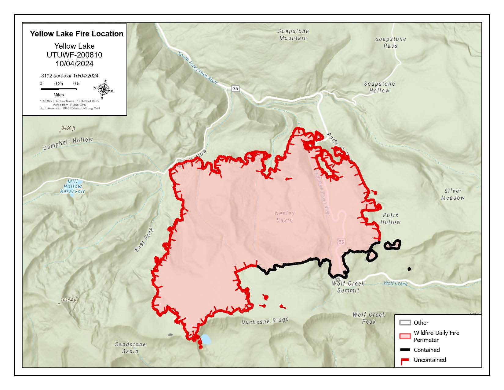
Yellow Lake Fire 10 04 2024
Related Incident: Yellow Lake Fire
Publication Type: News
Oct 4, 2024— Thanks to continued hard work by fire crews, the Yellow Lake Fire is 18% contained, and currently mapped at 3112 acres. With the increased acreage, the containment percentage has decreased slightly. A red flag warning is in effect, and the area continues to see unseasonably high warm and dry conditions.
The fire had been slowly backing down Highway 35. Yesterday’s firing operations were highly successful to reduce the unburned fuel between the road and the fire perimeter. This decreases the potential for spotting and reduces the time a Highway closure is needed. Firing operations did increase smoke, which was expected based on the fuel conditions in the area. The northwest side also completed firing operations from the dozer line towards the fire edge, while winds were favorable. Highway 35 remains closed for at least 24-48 more hours, until fire activity decreases and the road can be cleared of debris.
Most of the containment has been accomplished on the southern perimeter. Where safe to do so, crews are working further into the burned area to extinguish any hot spots. The southwest corner has many snags and hazardous trees. Areas where conditions are too dangerous to put crews in, fire managers are discussing future firing operations aligned with favorable weather. This will minimize the risk to firefighters.
The YMCA camp and ranger station remain safe, with structure protection complete and sprinklers and hose-lay in place for added defense. The previous logging and vegetation thinning done in this area made the structures much more defensible.
A forest closure officially went into effect yesterday for both the Uinta-Wasatch-Cache and Ashley National Forests. While crews are hoping to confine the fire within the current built indirect line, the forest closure is intended for potential fire activity if it crosses the current indirect line. With the heavy timber, high winds, and dry conditions, there is potential for the fire to spot large distances like has already occurred on this fire. Forest managers want to make sure they take a conservative approach with the predicted weather, red flag warning, and unseasonably dangerous conditions to assure public and firefighter safety.
The fire has been determined to be human caused, but it is still under investigation. More information will be released once the final investigation report is completed. There are no reportable accidents or injuries, and still no structures or recreational vehicles lost.
The Yellow Lake Fire is located east of Mill Hollow Reservoir on the Uinta-Wasatch-Cache National Forest, with 423 personnel assigned to the incident.
Happy Fire Update October 23 2024 10 03 2024
Related Incident: Happy
Publication Type: News
Oct 23, 2024 - This morning Firewatch 51 mapped the fire at 6,303 Acres which is a growth of 96 acres since the last mapping on 10/20 with 766 on KNP. The IR flight did pick up a heat signature in the rocks on the SNF side of the Monarch Divide at Happy Gap. There was minimal heat showing on the southern end of the fire with the exception of the Grizzly Creek and Wren Creek confluence where the fire is slowing moving between the rocks. The majority of activity is still within the Lewis Creek drainage as the fire continues to move East and Northeast. Now that the southern portion of the fire has been secured along Highway 180 the resources assigned have continued to prep control lines east from Lewis creek to Hole in the Wall near Cedar Grove in preparation for the fire to move down from Lewis Creek in the future. Line preparation should be completed by Friday 10/25 and so our plan is to return the fire to 100% monitor at 1800 on 10/25/2024. We plan to monitor the weather moving into the area between 10/28-10/29 for possible precipitation over the fire area with amounts still showing light in early models.
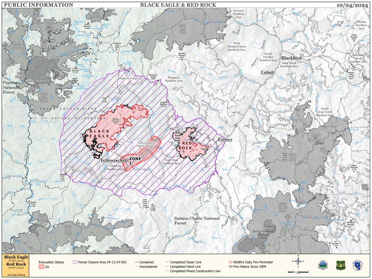
Red Rock and Black Eagle Fire Daily Update 10 04 2024
Related Incident:
Publication Type: News
RED FLAG WARNING ISSUED FOR RED ROCK AND BLACK EAGLE FIRE AREAS
WEATHER:
A Red Flag Warning for strong winds and low humidity is in effect for Friday between 12:00 p.m. and 9:00 p.m. Strong west to southwest winds 20-23 mph with gusts 40-50 mph are forecasted. Humidity will dip into the teens as a strong but dry cold front moves through the area Friday afternoon and evening. This front is not tapping into a large moisture source, so while humidity will go up Friday night, little to no rain is expected. The predicted weather will create an active fire environment in west to east drainages and in heavy dead and down fuels.
FIRE ACTIVITY:
The Red Rock Fire is at 3,576 acres and 78% containment.
Crews were successful in bringing the fire down to the Fourth of July Creek, but today backing fire will test the burnout operations in the area. The heat generated from heavy dead and down fuels will induce single and group tree torching, short range spotting, and short fire runs when alignments with slope or wind occur. Crews continue to monitor the control line, backhaul equipment, and work on suppression repair on the northwest, west, and south sides of the fire.
The Black Eagle Fire is at 7,936 acres and 16% containment.
Good overnight humidity recovery and cooler morning temperatures moderated fire activity on Thursday. As humidity dipped into the teens in the afternoon, and fuels were exposed to sunlight and west-southwest winds, the fire environment became more active, primarily in wilderness. Crews worked on structure preparation and sprinklers yesterday in the Yellowjacket area ahead of today’s wind event. Crews are also working in the Blackeagle Creek area, where fire behavior has increased and the fire is backing down to the creek.
FIRE BEHAVIOR:
Nearly all fuels are available across both fires, though heavy dead and down fuels remain most problematic for firefighters. Areas where humidities fall below 25% with gusty afternoon winds can experience increased activity, including short-range spotting. Opportunities to attack the fire directly will likely be confined to morning hours and when effective water support is available.
FOREST CLOSURES: For forest closure information please go to: https://www.fs.usda.gov/alerts/scnf/alerts-notices
EVACUATIONS: For evacuation information in Lemhi County regarding these fires please go to: Emergency Management Department | Lemhi County, ID (lemhicountyidaho.org).
Elk Fire Daily Update Friday October 4 2024 10 04 2024
Related Incident: Elk Fire 2024
Publication Type: News
Elk Fire Update - October 4, 2024
Rocky Mountain Area Complex Incident Management Team 3
Casey Cheesbrough, Incident Commander
Date Reported: Friday, September 27, 2024
Cause: Lightning
Size: 51,115
Containment: 0%
Total Personnel: 528
Location: Approximately 6 miles northwest of Dayton, Wyoming
Key Messages: A Red Flag Warning has been issued by the National Weather Service for Friday at noon until Saturday at 6:00 p.m. The forecast includes temperatures in the upper 70s to low 80s and relative humidity in the teens. Winds are forecast to shift from the southeast to southwest and west during the day, gusting up to 30pmh in the afternoon. Overnight tonight, the winds are expected to shift to be out of the northwest and gusting up to 50mph; this is associated with the passage of a cold front. With this anticipated hot, windy weather, it is likely that there will be an increase to the size of the fire.
With an anticipated increase in fire activity due to critical fire weather today through Saturday, please keep all county and local roads clear. If you stop to look, you could stop first responders.
Current Situation: After having previously used a bulldozer to create a fireline, fire crews utilized an Unmanned Aircraft System to implement a successful burnout operation west of the Horseshoe Subdivision yesterday. By intentionally placing fire on the ground between the fireline and the main fire, fire managers were able control the rate at which the vegetation was burned under calmer conditions. This tactic was utilized to lessen the chance of fire advancing upon structures in the future. Overnight, crews continued burning vegetation to increase the distance between structures and the southeast side of the main fire.
Today, crews will continue preparing structures to be defensible from fire in the Little Bighorn Canyon. Along the eastern side of the fire, crews will continue to extinguish areas of heat along established firelines. This same work will be done in the vicinity of yesterday's burning operation. Around the perimeter of the fire, crews will use a variety of structure preparation techniques, including the removal of vegetation near structures, constructing fireline, and placing hose and sprinklers where possible.
Firefighter and public safety remain the top priority. The tactics used to suppress the fire will be determined by the terrain, fire and weather conditions, and medical response time with a focus on only implementing plans and tactics that have a high probability of success.
Closures and Evacuations: In advance of the forecast weather, additional evacuation levels were added yesterday afternoon by the Sheridan County Sheriff; all previous evacuation levels remain in place. Please contact the Sheridan County Sheriff’s Office at 307-672-3455 or Sheridan County Emergency Management at 307-752-2174 for more information.
US Highway 14 remains closed from Dayton to Burgess Junction. For additional road closures, please visit the Sheridan County Emergency Management website at Sheridan County (sheridancountywy.gov).
ELK FIRE INFORMATION
Fire Information Phoneline: 307-303-7642 Time: 8:00 a.m. to 8:00 p.m.
Facebook: https://www.facebook.com/bighornnf
Email: 2024.elk@firenet.gov
InciWeb: inciweb.wildfire.gov/incident-information/wybhf-elk-fire-2024