
Incident Publication
KXGV Radio Show Oct 4 2024 10 04 2024
Related Incident:
Publication Type: Announcement
Garden Valley's KXGV Radio Interview with Ryan Leach, Incident Meteorologist (IMET)
Ryan Leach, Incident Meteorologist on for the Middle Fork Complex Fires discusses expected "Red Flag" weather conditions and smoke on Garden Valley Community Radio.
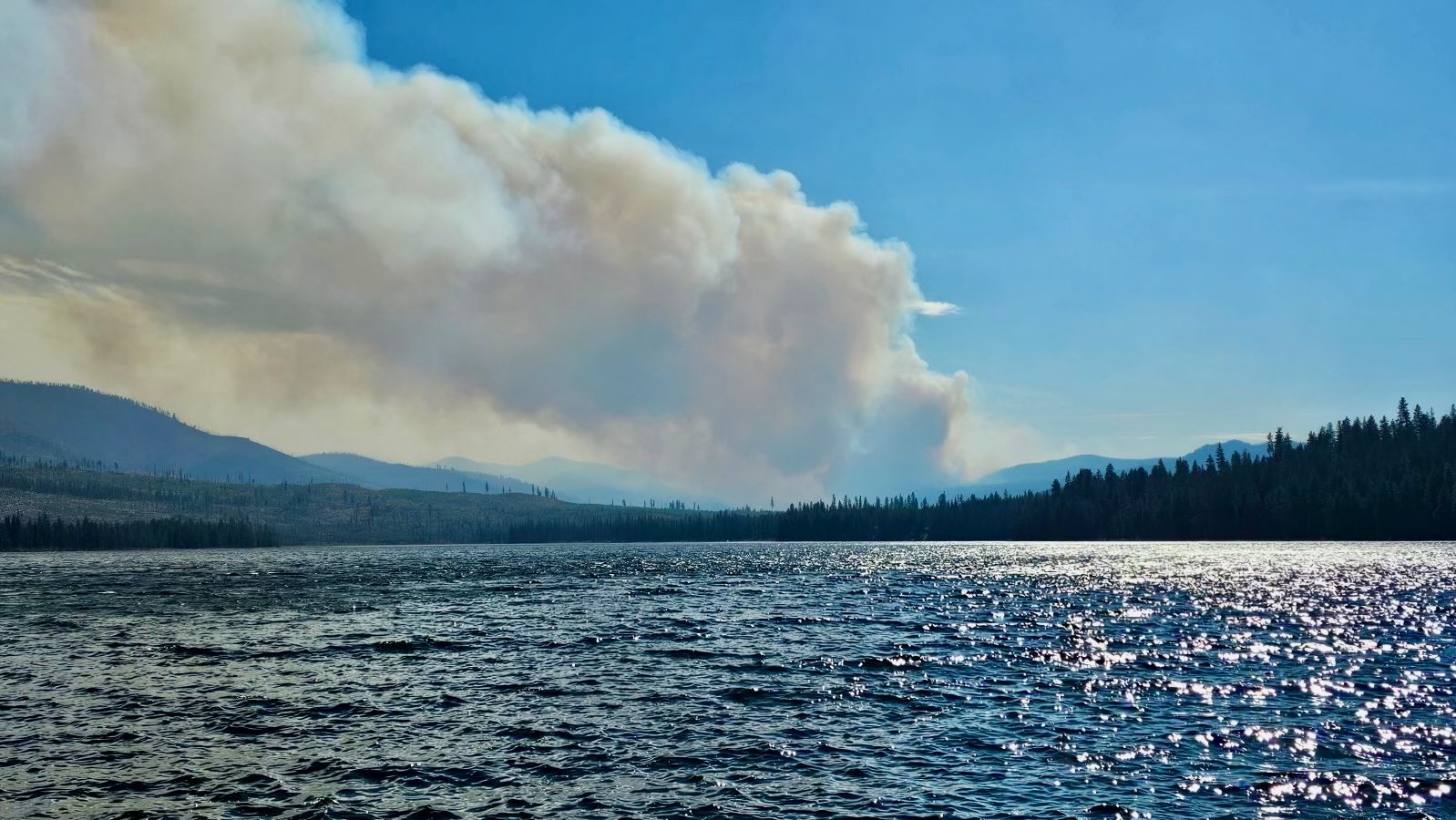
KXGV Radio Show Oct 2 2024 10 02 2024
Related Incident:
Publication Type: Announcement
Garden Valley's KXGV Radio Interviews Jesse Trembly, Operations Section Chief Trainee
Jesse Trembly, Operations Section Chief Trainee with Great Basin Team 6 discusses current operations on the Middle Fork Complex (Nellie, Goat, Snag and Bulldog Fires).
Warm Lake on Ready Evacuation Status 10 04 2024
Related Incident:
Publication Type: Announcement
This message is from the Valley County Sheriff's Office and was issued at 3:42 p.m. on October 4, 2024: Due to the red flag weather warning and windy conditions, the Goat Fire is moving towards Warm Lake. We are placing all of Warm Lake on a "ready" evacuation notice. For more information you can contact our dispatch center at 208-382-5160. Warm Lake Road is open to travel, there are no restrictions at this time.
KXGV Radio Show Sept 30 2024 09 30 2024
Related Incident:
Publication Type: Announcement
Garden Valley's KXGV Radio Interview with Incident Commander's Mack McFarland and Tony DeMasters
KXGV Community Radio 98.5 radio host Uncle Doug interviews two Incident Commanders (IC) for an update on the Middle Fork Fire Complex, Snag and Goat Fires. Outgoing IC Tony DeMasters from the Great Basin Team 2, and incoming IC Mack McFarland with Great Basin Team 6 share latest news about the three fires.
VIDEO 20240930 KXGV Radio Mack McFarland & Tony DeMasters ID BOF 000936 DWalsh - YouTube
Fish Creek and Pack Trail Daily Update 10 04 2024
Related Incident:
Publication Type: News
Public Meeting - A public meeting to discuss the current fire situation is scheduled for today, Friday, October 4 at 6:00 p.m. The meeting will be held in the Canteen Building at the National Museum of Military Vehicles, 6419 US 26, Dubois, WY. The meeting will be livestreamed from the Bridger-Teton FB page. (Video will be titled: Pack Trail & Fish Creek Fire Community Meeting)
Weather - The National Weather Service in Riverton has issued a Red Flag Warning in effect from noon today through 9:00 p.m. Sunday night, including Fremont County. Low humidities, unseasonably warm temperatures, and strong gusty winds could cause erratic fire behavior. Wind gusts could exceed 50 mph.
Operations - The Fish Creek fire experienced minor fire activity on the north side yesterday, but those areas were quickly addressed by ground and air resources. The Pack Trail fire saw small growth in the Trout and Buckskin Creek drainages and some slow backing towards the confluence of North and South forks of Fish Creek was observed.
On the Pack Trail Fire, firefighters worked on the shaded fuel break farther down the 540 road towards Pellham Lake, while structure protection groups continued preparations on the US-26 corridor up towards Pinnacle and Brooks Lake. Hotshot crews in Trout Creek area continue scouting locations to establish control line between the Lava Mountain and the Purdy fire burn scars. Additional resources are enroute to ICP in Dubois and expected to arrive today and tomorrow.
Safety - Teton Interagency Fire managers elevated the fire danger rating to Very High for Grand Teton National Park, the Bridger-Teton National Forest, and the National Elk Refuge. This means fires can start easily from most causes and may spread rapidly, becoming large fires and exhibiting extreme fire intensity, Residents and visitors are urged to exercise extreme caution with fire or possible ignition sources, including campfires.
Drivers on US-26 may experience periods of smoke today due to high winds. Please use caution while driving, use headlights, and expect to encounter fire vehicles along the road.
Closures - Closure Order #04-03-24-314 is in effect from October 1 through October 15, 2024 at 6:00 a.m. unless rescinded. This order supersedes previous orders, including #04-03-24-313, prohibiting the same or similar acts in the same described area. Click here to access the closure order and map on InciWeb.
Evacuations - Evacuations and evacuation alerts for several subdivisions and ranches in Fremont County, WY remain in place. See the Fremont County Emergency Management Fackbook Page for alerts and current status.
Facebook: USDA Forest Service - Bridger-Teton National Forest, USDA Forest Service - Shoshone National Forest
Pack Trail Inciweb: https://inciweb.wildfire.gov/incident-information/wybtf-pack-trail-fire
Fish Creek Inciweb: https://inciweb.wildfire.gov/incident-information/wybtf-fish-creek-fire
daily Update 10 04 2024
Related Incident:
Publication Type: News
Public Meeting - A public meeting to discuss the current fire situation is scheduled for today, Friday, October 4 at 6:00 p.m. The meeting will be held in the Canteen Building at the National Museum of Military Vehicles, 6419 US 26, Dubois, WY. The meeting will be livestreamed from the Bridger-Teton FB page. (Video will be titled: Pack Trail & Fish Creek Fire Community Meeting)
Weather - The National Weather Service in Riverton has issued a Red Flag Warning in effect from noon today through 9:00 p.m. Sunday night, including Fremont County. Low humidities, unseasonably warm temperatures, and strong gusty winds could cause erratic fire behavior. Wind gusts could exceed 50 mph.
Operations - The Fish Creek fire experienced minor fire activity on the north side yesterday, but those areas were quickly addressed by ground and air resources. The Pack Trail fire saw small growth in the Trout and Buckskin Creek drainages and some slow backing towards the confluence of North and South forks of Fish Creek was observed.
On the Pack Trail Fire, firefighters worked on the shaded fuel break farther down the 540 road towards Pellham Lake, while structure protection groups continued preparations on the US-26 corridor up towards Pinnacle and Brooks Lake. Hotshot crews in Trout Creek area continue scouting locations to establish control line between the Lava Mountain and the Purdy fire burn scars. Additional resources are enroute to ICP in Dubois and expected to arrive today and tomorrow.
Safety - Teton Interagency Fire managers elevated the fire danger rating to Very High for Grand Teton National Park, the Bridger-Teton National Forest, and the National Elk Refuge. This means fires can start easily from most causes and may spread rapidly, becoming large fires and exhibiting extreme fire intensity, Residents and visitors are urged to exercise extreme caution with fire or possible ignition sources, including campfires.
Drivers on US-26 may experience periods of smoke today due to high winds. Please use caution while driving, use headlights, and expect to encounter fire vehicles along the road.
Closures - Closure Order #04-03-24-314 is in effect from October 1 through October 15, 2024 at 6:00 a.m. unless rescinded. This order supersedes previous orders, including #04-03-24-313, prohibiting the same or similar acts in the same described area. Click here to access the closure order and map on InciWeb.
Evacuations - Evacuations and evacuation alerts for several subdivisions and ranches in Fremont County, WY remain in place. See the Fremont County Emergency Management Fackbook Page for alerts and current status.
Facebook: USDA Forest Service - Bridger-Teton National Forest, USDA Forest Service - Shoshone National Forest
Pack Trail Inciweb: https://inciweb.wildfire.gov/incident-information/wybtf-pack-trail-fire
Fish Creek Inciweb: https://inciweb.wildfire.gov/incident-information/wybtf-fish-creek-fire
Homestead Emergency Fire Closure USFS Order 0615012501 10 04 2024
Related Incident: Lane 1 Fire
Publication Type: Closures
UNITED STATES DEPARTMENT OF AGRICULTURE, FOREST SERVICE
Umpqua National Forest. Roseburg, OR
ORDER NO. 06-15-01-25-01
HOMESTEAD EMERGENCY FIRE CLOSURE
Pursuant to 16 USC § 551 and 36 CFR § 261.50 (a) and (b), and to provide for public safety, the following acts are prohibited upon the roads, trails, and general forest areas within the Umpqua National Forest as described below and shown in Exhibit A. This Order is effective October 4, 2024, through February 5, 2025, unless rescinded sooner. This order rescinds and supersedes Closure Order No. 06-15-01-24-01, signed September 24, 2024.
PROHIBITIONS:
1. Being on a road. [36 CFR § 261.54 (e)]
2. Going into or being upon an area closed for the protection of public health and safety. [36 CFR§261.52 (e)]
3. Being on a trail. [36 CFR § 261.55(a)]
CLOSURE AREA:
The Closure Area is described as an area starting in T25S, R01W, Section 28 at the intersection of Forest Service Road (FSR) 38 and FSR 3806, following the northern edge of FSR 38 east to FSR 4760, following FSR 4760 east to FSR 3810, following FSR 3810 east to Singe Creek, following Singe Creek southeast to FSR 4760-100, following FSR 4760-100 southwest to FSR 4760, following FSR 4760 south to Eagle Creek, following Eagle Creek southeast to Forest Service Trail (FST) 1414, The North Umpqua Trail, following The North Umpqua Trail east to FSR 4775, following FSR 4775 northeast to FSR 4775-700, following FSR 4775-700 north to FST 1487, following FST 1487 north to FSR 3810, following FSR 3810 north to FST 1486, following FST 1486 north to FSR 3402-801, following FSR 3402-801 east to FSR 3402-800, following FSR 3402-800 east to FSR 3402, following FSR 3402 east to FSR 34, following FSR 34 northeast to The Umpqua National Forest Boundary, following The Umpqua National Forest Boundary northwest to FSR 2213-745, following FSR 2213-745 east to FSR 2212-767, following FSR 2212-767 northwest to FSR 2212, following FSR 2212 southwest to County Road 2460, following County Road 2460 west to FST 1407, following FST 1407 south to FSR 3828-176, following FSR 3828-176 southwest to FSR 2358, following FSR2358 to FSR 23, following FSR 23 south to the Umpqua National Forest Boundary, following the Umpqua National Forest Boundary south to High Power Creek Drainage, following High Power Creek Drainage west to FSR 3806, following FSR 3806 southeast back to the point of origin in T25S, R01W, Section 28 at the intersection of FSR 38 and FSR 3806.
The Closure Area described above is shown on the attached Exhibit A.
EXEMPTIONS:
Pursuant to 36 CFR § 261.50(e), the following persons are exempt from this order:
1. Persons with Forest Service Permit No. FS-7700-48 (permit for Use of Roads, Trails, or AreasRestricted by Regulation or Order), specifically exempting them from this order.
2. Any Federal, State, or local officer, or member of any organized rescue or fire fighting force inthe performance of an official duty.
3. Steamboat Falls Campground will remain open.
4. The closure status of roads, lands, and trails not under Umpqua National Forest jurisdiction willbe determined by the corresponding agency or government entity. For the status of Highway 138,please go to tripcheck.com.
These prohibitions are in addition to the general prohibitions in 36 C.F.R. Part 261, Subpart A. Violations of this prohibition are punishable by a fine of not more than $5,000 for an individual or $10,000 for an organization, or imprisonment for not more than 6 months, or both (16 U.S.C. § 551; 18 U.S.C. §§ 3351, 3559, 3571, and 3581).
Executed on October 4, 2024, in Roseburg, Oregon.
Alice Carlton
Forest Supervisor, Umpqua National Forest
Red Fire Update 10 04 2024
Related Incident: Red Fire
Publication Type: News
Red Fire Quick Facts - Oct. 4, 2024
Size: 2,500 acres
Containment: 11%
Personnel: 73
Crews are prepared for strong winds, warm temperatures, and lower relative humidity levels today. The Incident Management Team has been planning and preparing for the incoming weather. Water tenders have been pretreating the vegetation along control lines to significantly reduce the potential for the fire to spot over established firelines. Resources have also been testing and operating all pumps, hoses, and sprinklers in place along control lines and near structures to ensure they are ready if needed.
Aviation resources will be available to support suppression efforts if needed. Water tenders will continue to pretreat the south side of Forest Service Road (FSR) 60 with water to reduce the potential for spot fires over the road. Firefighters will be patrolling and are prepared to engage the fire as needed with engines and established hose lays along the shaded fuel breaks.
The Red Fire remains north of FSR 60. Recent Infrared (IR) mapping shows the fire has crossed FSR 60, that is not the case and is a misrepresentation from the IR flight. This is being corrected. The fire has reached the established shaded fuel breaks along FSR 60 north of Whitefish Horse Camp in the Tranquil Cove area and between Greenwood Point and Zims Point as anticipated.
Air Attack flew over the fire first thing this morning and the observed fire behavior was low to moderate.
Bachelor Complex Update 10 04 2024
Related Incident: Bachelor Complex Fires
Publication Type: News
Bachelor Complex Quick Facts – Oct. 4, 2024
Size: 11,950
Containment: 55%
Personnel: 70
Start Date: September 8, 2024
Location: 20 miles SW Bend, OR
Today, weather conditions are expected to be warm and dry with strong southwest winds up to 30 mph. Increased fire behavior and smoke are anticipated on the Little Lava Fire due to these conditions. In preparation for the incoming weather, firefighters completed successful strategic burning operations yesterday on the northern flank along Edison #3 Trail to establish a potential control feature with the goal of preventing growth to the east. Forest Service Road 4526 has also been prepared as an alternate control line further east. The fire is expected to continue slowly burning north.
Firefighters will focus on patrolling and holding existing control and containment lines throughout the day. Aircraft will be available to support suppression efforts if needed.
Rail Ridge Update 10 04 2024
Related Incident:
Publication Type: News
Rail Ridge Fire Update
October 04, 2024
Central Oregon Wildfire Information: centraloregonfire.org
Email: 2024.railridge@firenet.gov – Phone: 541-208-7111
Social Media, Evacuation and Closure Information: https://linktr.ee/RailRidgeFire
Acres: 167,718 – Containment: 89% – Detection: 09/02/24 – Cause: Lightning – Personnel: 617
A critical weather day is expected this afternoon over the Rail Ridge Fire. A cold front will pass over the fire around noon with wind gusts of 25-30 mph from the southwest switching to westerly/northwesterly with increasing gusts of 30-35 mph as the front passes. Going into the weekend calmer winds and higher relative humidity will be present over the fire area.
Operational Update
Yesterday, in the Black Canyon Wilderness, on the south side of Black Canyon Creek, the fire continued to burn toward the west. Crews and dozers continued constructing contingency control lines around the north and west sides in preparation of today’s weather. Uncontained areas on the north side of the fire that are inaccessible due to steep terrain were monitored and stayed in place throughout the day. One small slopover was found on the overnight IR flight on the eastern line of the fire and was suppressed early in the day. In anticipation of the strong South/Southwest winds predicted for today, crews worked with a helicopter dropping water on the hottest areas on the Eastern edge of the fire footprint. All around the contained fire edge, firefighters continued mop-up, patrol and suppression repair.
Today, firefighters will be on a heightened alert for the high winds and low relative humidities predicted for the afternoon hours. There is potential for high fire activity in the wilderness and areas throughout the fire that continue to have heat and areas of unburned fuels within the fire footprint. Firefighters continue to work the eastern edge of the fire to mop-up heat along the fires edge that will be tested by the south/southwesterly winds predicted for this afternoon. Firefighters will continue to construct contingency control lines and strengthen containment around the Black Canyon Wilderness, adding depth to lines that are already in place as the weather allows. Suppression repairs are ongoing with resource advisors and mop-up and patrolling will continue around the contained portions of the fire. Much higher relative humidity, cooler night temperatures, and moderating winds through the weekend will be a welcome weather break for fire personnel.
Weather: A cold start in the morning hours today will lead to similar temperatures as yesterday in the low 70’s. Expect gust of winds between 25-35 mph throughout the afternoon before weather conditions moderate and steady out towards the weekend.
Evacuations
Level 1 evacuations in Grant County were dropped yesterday and the level 2 evacuations remain. Wheeler County evacuation remain the same.
For Current Evacuation Levels all affected counties, please visit: https://linktr.ee/RailRidgeFire
Closures: The U.S. Forest Service and Bureau of Land Management have implemented closures for the Rail Ridge Fire. For more details and closure maps, visit https://linktr.ee/RailRidgeFire