
Incident Publication
Forest Service to Conduct Prescribed Burns in Hyalite Canyon and in the North Bridgers near South Fork Brackett Creek and Lower Fairy Lake Road 09 30 2024
Related Incident: 2024 Custer Gallatin National Forest Prescribed Fire Program
Publication Type: News
Bozeman, MT September 29, 2024 - Forest Service fire crews plan to conduct a prescribed burn the week of September 30th – October 4th in Hyalite Canyon, approximately one mile west of Langohr campground. Crews will also focus on prescribed burns in the North Bridgers, near the South Fork Brackett Creek area and near the Lower Fairy Lake Road. Burning may occur as early as October 2, 2024, and will continue as conditions permit.
“Implementing prescribed burns are an essential part in meeting the goals of the Municipal Watershed Project and the N. Bridger Forest Health Project” said Bozeman District Ranger, Corey Lewellen. “We don’t take the use of prescribed fire lightly and we have a very strategic burn plan, with built in contingencies, to successfully conduct our operations.”
Hyalite Area
In Hyalite Canyon, fire managers expect to conduct prescribed burning on 116 acres within the Bozeman Municipal Watershed, BMW Unit 19, off the Langohr Road. Expect closures on the Langohr Road (#6230) and on nearby trails. Langohr Campground will also be closed beginning Monday, September 30th, through the duration of burning activities. This prescribed burn aims to reduce fuel loads and lower the risk of high severity wildland fires in the Bozeman Municipal Watershed.
The prescribed burn is anticipated to last between one and three days. During operations, smoke and flames may be visible and smoke is expected to settle in low-lying areas near the burn overnight. Air quality is a key factor considered by land and fire managers during every phase of the prescribed fire and burning is only permitted when weather conditions are suitable for safe operations. Fire officials collaborate with the National Weather Service to ensure that the weather is favorable before, during, and after burning, as well as with the Montana Department of Environmental Quality to ensure smoke dispersal opportunities.
Hyalite Canyon traffic has only one way in and one way out. To ensure safety during operations, delays may occur as crews utilize Hyalite Canyon Road. Please exercise caution if traveling in the area as roadways may be impacted by smoke and fire traffic.
South Fork Brackett Creek and Lower Fairy Lake Road
Fire managers also expect to conduct prescribed burning on 34 acres in the North Bridgers Forest Health project area located near the South Fork Brackett Creek (North Bridgers Unit 51) and on 18 acres near Lower Fairy Lake Road (North Bridgers Unit 13). Closures may be put in place on the South Brackett Road (#631) to Ross Pass trailhead, nearby trails (#525, #539, and #551), on the Fairy Lake Road (#74), and nearby trails (#500, #527, and #540). Loggers loop, which begins in Crosscut, will also be closed at the forest boundary. The prescribed burns are anticipated to last between one and three days.
For additional information on these prescribed burns or how current closures could impact your visit to the forest, please visit us online at www.bznwatershed.com, on Facebook at Custer Gallatin National Forest, on Inciweb at 2024 Custer Gallatin National Forest Prescribed Fire Program or by calling the Bozeman Ranger District office at 406-522-2520. For additional information on the Forest Service Wildfire Crisis Strategy, please see Confronting the Wildfire Crisis | US Forest Service (usda.gov).
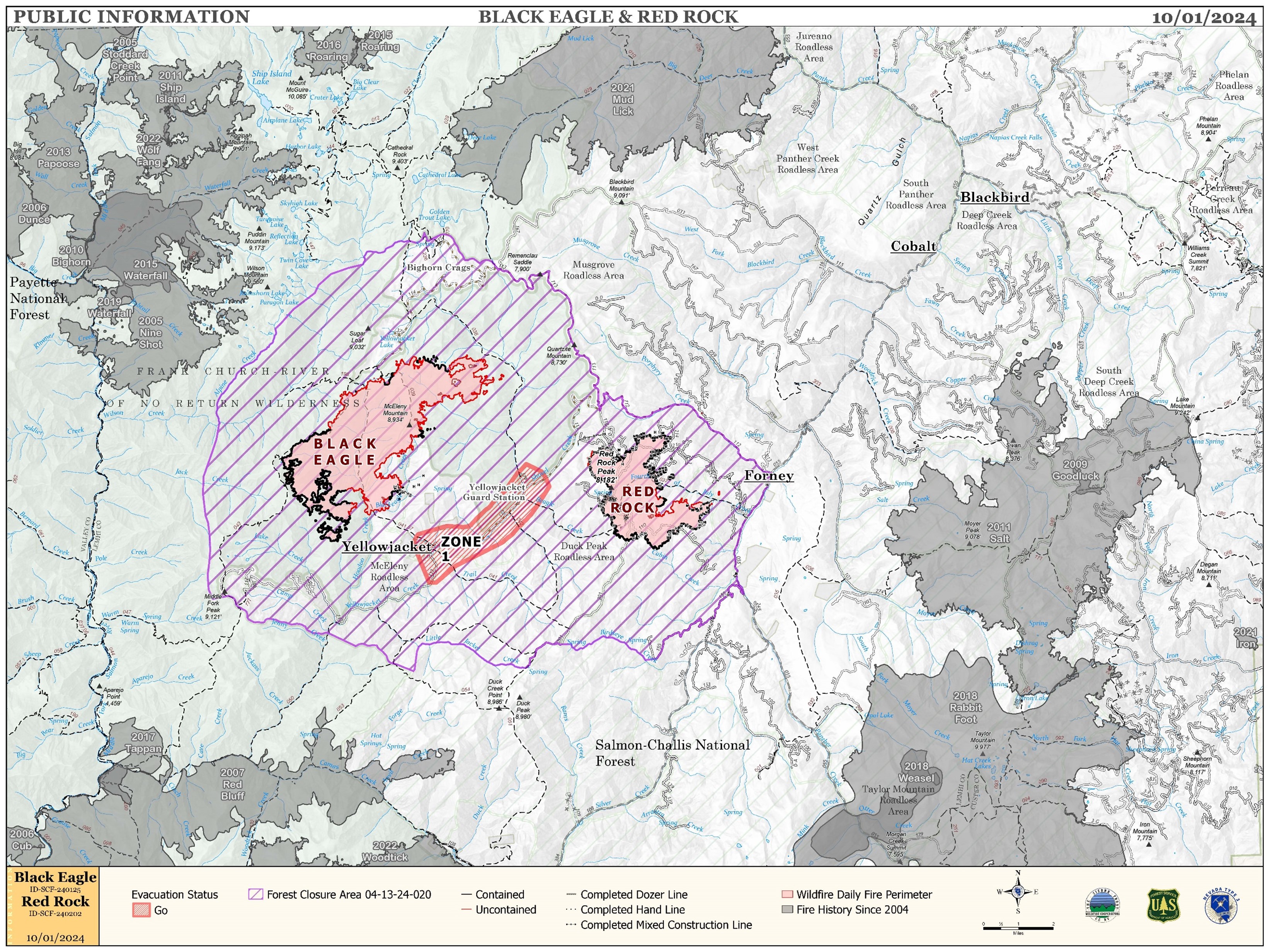
Red Rock and Black Eagle Fire Daily Update 10 01 2024
Related Incident:
Publication Type: News
IRE ACTIVITY:
The Red Rock Fire is at 3,367 acres and 75% containment.
Winds and fire activity moderated overnight with cooler temperatures. The majority of the fire faired very well through Sunday’s high winds; only the northeast side of the fire saw increased growth. The fire burning in the 4th of July drainage still poses control issues due to poor access and unsafe conditions for direct attack. Firefighters are building indirect line ahead of the fire to catch the fire if and when it crosses the drainage.
The Black Eagle Fire is at 7,433 acres and 8% containment.
The Black Eagle Fire saw considerable growth over Sunday’s wind event but nearly all of the added acres were in designated wilderness areas. The division outside of the wilderness is still under a full suppression strategy but areas are also difficult to access safely and indirect attack must be used to control the fire. Aircraft are still supporting both fires with bucket work to slow its progression and cool flare ups to avoid spot fires.
WEATHER:
A weak ridge of high pressure will build over the area today. The winds will remain westerly but increase slightly over yesterday. Much warmer temperatures today with high temperatures 13 degrees warmer than Monday. Slightly higher humidity, but still unseasonably dry for this time of year. A weak system in the north will move through Wednesday bumping winds up slightly. A stronger, but dry, system will move over the area Friday night.
FIRE BEHAVIOR:
Nearly all fuels are available across both fires, though heavy dead and down fuels remain most problematic for firefighters. Areas where humidities fall below 25% with gusty afternoon winds can experience increased activity, including short-range spotting. Opportunities to attack the fire directly will likely be confined to morning hours and when effective water support is available.
FOREST CLOSURES: For forest closure information please go to: https://www.fs.usda.gov/alerts/scnf/alerts-notices
EVACUATIONS: For evacuation information in Lemhi County regarding these fires please go to: Emergency Management Department | Lemhi County, ID (lemhicountyidaho.org).
Boise National Forest Reduces Fire Closure Areas Oct 1 2024 10 01 2024
Related Incident:
Publication Type: Closures
Forest Service News Release
Boise National Forest
Contact: Michael Williamson, Public Affairs Officer, 208-204-4484, michael.williamson@usda.gov
Boise National Forest reduces fire closure areas
BOISE, Idaho, Oct. 1, 2024 – The Boise National Forest has reduced several wildfire closure areas surrounding the Lava, Snag, Goat, and Middle Fork Complex fires. These closure adjustments have been made due to progress by firefighters and reduced fire activity.
Lava Fire: The southern boundary of this closure area has been moved north and west allowing access to Sage Hen Reservoir and Tripod Meadows via roads 644 and 626 west of Smiths Ferry. No adjustments have been made along the Lake Cascade portion of the closure area as Snowbank Road (446) and road 435 remain closed.
Middle Fork Complex: The updated closure area is primarily the footprint of the Bulldog and Nellie fires’ themselves and the area between these two fires. Roads 698 and 671 north of Crouch are now open, allowing access to the Silver Creek Plunge area. However, road 678 and Boiling Springs Campground remain closed due to proximity to the Goat Fire. Road 555 from Highway 21 to Deadwood Reservoir remains closed.
Snag and Goat fires: The closure area’s new northern boundary is the Warm Lake Highway (which remains open), and that portion of the Snag Fire that burned north of the highway. The east side of the closure has moved west, opening the Deadwood River drainage north of Deadwood Reservoir.
Wapiti Fire: We expect reductions to the Wapiti Fire closure area to be announced later this week.
Please refer to the maps and closure orders on the Boise National Forest’s Alerts and Notices webpage and Interactive Forest Closure Map for specific details.
These closure areas are for public and firefighter safety. While some roads are opened back up, please watch for firefighting traffic.
###
Bachelor Complex Update 09 30 2024
Related Incident: Bachelor Complex Fires
Publication Type: News
Bachelor Complex Fire Update
September 30, 2024
Quick Facts: Bachelor Complex
Size: 11,742 acres
Start Date: September 8, 2024
Location: 20 miles SW Bend, OR
Personnel: 135
Containment: 50%
Beginning tomorrow, October 1st, information of significance for the Bachelor Complex will be shared through Central OR Fire X/Twitter (@CentralORFire) and the Deschutes National Forest Facebook page. The Bachelor Complex email and fire information phone line will no longer be staffed and Inciweb will be updated intermittently.
The Central Oregon Interagency Type 3 Management Team continues to manage the Bachelor Complex and are assessing the time frame to transition back to a local unit Type 4 Incident Commander.
A temporary emergency fire closure remains in place for the Bachelor Complex. To view the most recent closure order and map, visit the Deschutes National Forest website at: https://www.fs.usda.gov/alerts/deschutes/alerts-notices.
Bachelor Complex:
Isolated heat and smoke will continue to be seen across the southern edge of the fire. Firefighters are mopping-up areas of heat closest to the fire’s perimeter. Crews continue the cutting and chipping preparation along Forest Service Roads 4525 and 4529 in the southwestern area of the fire to establish containment features. Firefighters will monitor and patrol the lines in the northeast area of the fire as the objectives in that area have been met and suppression repair efforts continue. Backhaul of supplies that are no longer needed is occurring across the fire area.
Weather and Fire Behavior:
A weak ridge of high pressure will begin to move back into the area today becoming stronger on Tuesday. Temperatures will be a few degrees warmer than Sunday with highs ranging from the lower 60s to lower 70s. Northeast winds of 5 to 10 mph are expected with gusts approaching 15 mph. Humidity values will continue to range from the teens to 20s during the afternoon. Temperatures Tuesday will be returning to the 70s and 80s across the fire.
Facbook: https://www.facebook.com/deschutesnationalforest
Twitter/X: https://twitter.com/CentralORFire
InciWeb: https://inciweb.wildfire.gov/incident-information/ordef-bachelor-complex-fires
Smoke & Air Quality Information: fire.airnow.gov
Middle Fork Complex Daily Update Oct 1st 2024 10 01 2024
Related Incident:
Publication Type: News
Middle Fork Complex Fire Update
October 1, 2024
Middle Fork Fire Information: 208-992-3045 (8 a.m. – 8 p.m.) | Email: 2024.middleforkcomplex@firenet.gov
Middle Fork Complex: 61,484 acres, 90% completion, 400 Personnel
Snag Fire: 33,436 acres, 90% completion, 41 Personnel
Goat Fire: 27,131 acres, 46% completion, 41 personnel
Middle Fork Complex: Fire behavior has been mild smoldering and creeping with no intense or scattered heat near the perimeter. Suppression repair continues in the Deadwood Reservoir. The closure areas remain in effect and heavy equipment and crews remain engaged in fire suppression repair work. The public is asked to use extra caution when traveling in the area.
Goat: Fire behavior is mainly smoldering and creeping with several small areas of intense heat along the southern and the northeastern perimeters. There are also several inaccessible interior areas with intense heat. Crews have completed most of the repair work around Clear Creek and continue suppression repair in the private lands near there. Hand crews continue increasing the depth of mop-up efforts along containment lines. Engine companies and crews continue to evaluate and protect confinement lines in the northeast corner of the fire.
Snag: Fire behavior is mostly smoldering with some creeping and no intense or scattered heat near the perimeter. Suppression repair continues across the fire area the primary focus on hand and dozer lines. Firefighters continue to evaluate and strengthening containment lines continues along the western side of the fire. Repair work of many of the roads used by fire personnel in the area will continue.
Great Basin Incident Management Team 6, led by Mack McFarland, Incident Commander, assumed control of Middle Fork Complex at 6 a.m. today as Great Basin Team 2 rotates back home for some much-deserved rest. McFarland pointed out that the diligent planning and hard work of Team 2 was much appreciated and has set Team 6 up for success over the next couple of weeks.
Weather Outlook: High pressure and gusty conditions are expected to continue with overnight, humidity recovery remaining in the teens over most of the fire area. Temperatures are expected to be in the 50s at higher elevations and in the 60s to low 70s at lower elevations.
Closure Orders: https://www.fs.usda.gov/alerts/boise/alerts-notices
An updated forest closure order reducing the size of the closure has been posted to the Boise National Forest Facebook page. To assist with firefighter access to the areas and avoid heavy equipment, hunters and other public members are not allowed access to areas that are still closed.
Fire Restrictions: Stage 1 Fire Restrictions have been rescinded for the Boise National Forest. For more information on the restrictions visit https://www.fs.usda.gov/alerts/boise/alerts-notices.
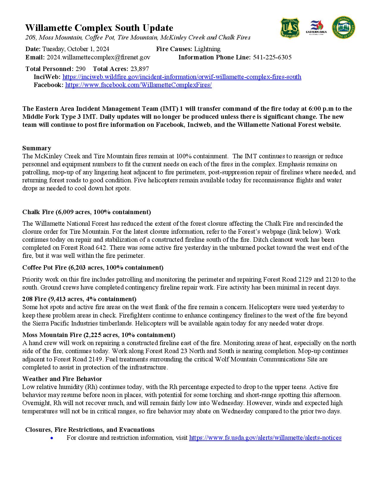
Willamette Complex South Daily Update for Tuesday 10 01 2024
Related Incident: Willamette Complex Fires - South
Publication Type: News
Willamette Complex South Update
208, Moss Mountain, Coffee Pot, Tire Mountain, McKinley Creek and Chalk Fires
Date: Tuesday, October 1, 2024
Fire Causes: Lightning
Email: 2024.willamettecomplex@firenet.gov
Information Phone Line: 541-225-6305
Total Personnel: 290
Total Acres: 23,897
InciWeb: https://inciweb.wildfire.gov/incident-information/orwif-willamette-complex-fires-south
Facebook: https://www.facebook.com/WillametteComplexFires/
The Eastern Area Incident Management Team (IMT) 1 will transfer command of the fire today at 6:00 p.m to the Middle Fork Type 3 IMT. Daily updates will no longer be produced unless there is significant change. The new team will continue to post fire information on Facebook, Inciweb, and the Willamette National Forest website.
Summary
The McKinley Creek and Tire Mountain fires remain at 100% containment. The IMT continues to reassign or reduce personnel and equipment numbers to fit the current needs on each of the fires in the complex. Emphasis remains on patrolling, mop-up of any lingering heat adjacent to fire perimeters, post-suppression repair of firelines where needed, and returning forest roads to good condition. Five helicopters remain available today for reconnaissance flights and water drops as needed to cool down hot spots.
Chalk Fire (6,009 acres, 100% containment)
The Willamette National Forest has reduced the extent of the forest closure affecting the Chalk Fire and rescinded the closure order for Tire Mountain. For the latest closure information, refer to the Forest’s webpage (link below). Work continues today on repair and stabilization of a constructed fireline south of the fire. Ditch cleanout work has been completed on Forest Road 642. There was some active fire yesterday in the unburned pocket toward the west end of the fire, but it was well within the fire perimeter.
Coffee Pot Fire (6,203 acres, 100% containment)
Priority work on this fire includes patrolling and monitoring the perimeter and repairing Forest Road 2129 and 2120 to the south. Ground crews have completed contingency fireline repair work. Fire activity has been minimal in recent days.
208 Fire (9,413 acres, 4% containment)
Some hot spots and active fire areas on the west flank of the fire remain a concern. Helicopters were used yesterday to keep these problem areas in check. Firefighters continue to enhance contingency firelines to the west of the fire beyond the Sierra Pacific Industries timberlands. Helicopters will be available again today for any needed water drops.
Moss Mountain Fire (2,225 acres, 10% containment)
A hand crew will work on repairing a constructed fireline east of the fire. Monitoring areas of heat, especially on the north side of the fire, continues today. Work along Forest Road 23 North and South is nearing completion. Mop-up continues adjacent to Forest Road 2149. Fuel treatments surrounding the critical Wolf Mountain Communications Site are completed to assist in protection of the infrastructure.
Weather and Fire Behavior
Low relative humidity (Rh) continues today, with the Rh percentage expected to drop to the upper teens. Active fire behavior may resume before noon in places, with potential for some torching and short-range spotting this afternoon. Overnight, Rh will not recover much, and will remain fairly low into Wednesday. However, winds and expected high temperatures will not be in critical ranges, so fire behavior may abate on Wednesday compared to the prior two days.
Closures, Fire Restrictions, and Evacuations
- For closure and restriction information, visit https://www.fs.usda.gov/alerts/willamette/alerts-notices
Line Fire fact Sheet 10 01 2024
Related Incident: Line Fire
Publication Type: News
Yesterday, fire behavior moderated on the Line Fire. The most active area was the Santa Ana River drainage with fire moving up the drainage to Sand Creek on the north and also near the community of Pinezanita. The fire burned to the community of Pinezanita but all residential structures were saved with quick action by firefighters. Six night-flying helicopters were dropping water in the Angelus Oaks area.
The fire is active in the Angelus Oaks area and burned up to Highway 38 just north of Angelus Oaks. There was spotting across Highway 38 but all spots were extinguished. Suppression operations are planned in the Angelus Oaks community today. Angelus Oaks was placed under an evacuation order yesterday for the safety of the community.
Crews continue to go direct with fire in the Bear and Siberia creek drainage when safe to do so in this very steep area. The western and southern perimeters of the fire remain in patrol and monitor status.
The closure orders for the Forest remain in place.
Public information line: 909.220.4292
Media Line: 925.542.9164
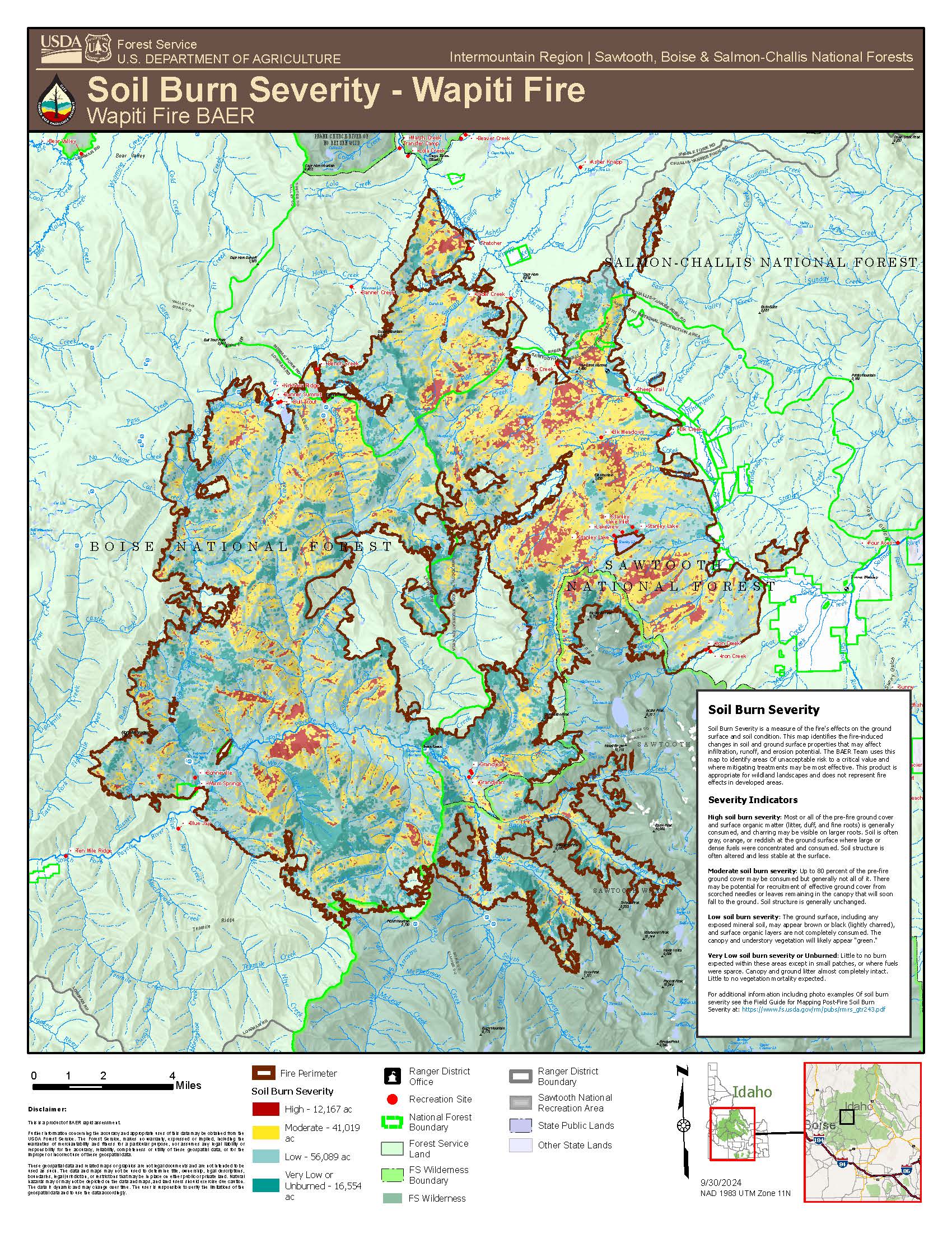
Wapiti Fire Soil Burn Severity Data Released 10 01 2024
Related Incident:
Publication Type: News
Wapiti Fire Soil Burn Severity Data Released
Burned Area Emergency Response (BAER) specialists from the USDA Forest Service have finalized the Soil Burn Severity map for the ~125,000-acre Wapiti Fire. Soil burn severity is classified into 4 levels: unburned, low, moderate and high.
BAER soil scientists used a satellite image product to prioritize locations in the field to assess soil burn severity. These individuals sampled accessible sites to evaluate soil changes caused by the fire. They collected information on ground cover, ash color, soil depth and structure, intact roots, and water repellency in order to build a picture of soil burn severity.
The analysis showed the following distribution of severity by acres and percentage:
Unburned: 16,554 (13%), Low: 56,089 (45%), Moderate: 41,019 (32%), High: 12,167 (10%)
BAER post-fire assessment teams use the soil burn severity data to identify if there are areas of concern where increased soil erosion, accelerated surface water run-off, and debris flows have the potential to impact human life and safety, property, and critical natural and cultural resources from rain events. BAER teams typically consist of scientists and specialists that consider emergency stabilization options for those critical resources.
The Soil Burn Severity map isn’t an erosion risk map, but generally, increases in the rates of erosion and run-off are expected from steep hillslopes with high and moderate soil burn severity. Areas located downstream from moderate and high soil burn severity, even within unburned areas, may experience increased rates of erosion, debris flows, and surface run-off due to cumulative effects.
SPECIAL NOTE: Everyone near and downstream from the Wapiti Fire burned area should remain alert and stay updated on weather conditions that may result in heavy rains over the burned area. Flash flooding could occur quickly during heavy rain events. Current weather and emergency notifications can be found at the National Weather Service (NWS), Pocatello (PIH) (https://www.weather.gov/pih/) or Boise (BOI) (https://www.weather.gov/boi/) websites.
Goosmus Fire Update 10012024 10 01 2024
Related Incident: Goosmus Fire
Publication Type: News
Yesterday, moderate fire behavior continued in the swales on the northeast of the fire (around Upper Danville Road), exhibiting visible smoke and some observed observable flames during minor torching. This activity remains within the interior and is not a threat to established fire lines. Crews have established over 2 miles of hose lay on the west side of the fire (near Big Goosmus Road), helping crews extinguish existing smoldering material along the fire line. In the 4th of July Creek Road area, crews were focused on structure protection measures and identifying areas burning near the fire line.
Today, crews will continue to construct hose lays on the westside of the fire. Crews will monitor areas of internal burning for possible threats to the fire line while working on increasing containment. Structure protection units will continue to patrol and mitigate around structures in the 4th of July Creek Road area. Firefighter and public safety remain our highest priority, crews are continuing to work in the area. Local residences and property owners entering the area should be cautious of crews working along 4th of July Creek Road and traveling along Big Goosmus Road, Brenner Road, and Parelandra Circle, as well as other local roads in the proximity of the fire perimeter.
Daily Fish Creek Fire Update for Tuesday 10 01 2024
Related Incident:
Publication Type: News
Tuesday, October 1, 2024
Total Acres: 25,081
Total Personnel: 115
Contained/Completed: 87%
A new Fish Creek and Pack Trail Fire Area, Road, and Trail Closure Order (order # 04-03-24-314) was issued by the Forest Service this morning. This order is in effect from October 1, 2024 at 6:00 am through October 15, 2024 at 6:00 am unless rescinded. This order supersedes any previous orders, including #04-03-24-313, prohibiting the same or similar acts in the same described area. Click here to access both the map and the closure order or use the links provided at the bottom of this page in the "Related Information" attachment box.
Today’s weather is expected to be similar to yesterday, though slight increases and wind are predicted and could lead to near critical fire weather conditions. Gusts of 25 mph are likely along higher terrain and the Highway 26 corridor this afternoon. Smoke may continue to impact travel along the highway.
There was minimal fire behavior on the Fish Creek Fire yesterday, with isolated areas of fire activity, primarily along the northwest, south, and southwest perimeter. Some helicopter bucket work was done in Split Rock Creek area at the head of Two Ocean Basin to reduce hot spots. Fire activity today is expected to be limited to backing, smoldering and isolated torching.
Crews today will continue to monitor potential threats to Highway 26 and other critical values at risk, track fire activity in the Cottonwood Drainage area and along the fire’s edge, and work on suppression repair on forest system roads in the fire area, including grading the Hatchet and Flagstaff Roads. Some fire personnel were reassigned from the Fish Creek Fire to the nearby Pack Trail Fire in order to strengthen structure protections along the Highway 26 corridor.
Due to current conditions and expected weather, residents and visitors are urged to exercise extreme caution with fire or possible ignition sources, including campfires, as well as stay out of posted closed areas and avoid areas around the fire impacted zones.