
Incident Publication
HomesteadDiamond Complexes Daily Fire Update 10 01 2024
Related Incident: Lane 1 Fire
Publication Type: News
Homestead/Diamond Complexes Fire Update
Oct. 1, 2024
Fire Information: 541-208-7100, 8 AM - 8 PM
InciWeb-Homestead: https://t.ly/syeHa and InciWeb-Diamond: https://bit.ly/4gCfLsp
Six fires within the Homestead and Diamond Complexes remain under active management by Northwest Team 12. Firefighting resources from the Homestead/Diamond Complexes remain available for initial attack response to new fire starts in the area as needed.
The Oregon Department of Transportation temporarily lowered the speed limit on Hwy 138 in front of the Fire Incident Command Post just east of Glide to 45 MPH for the safety of firefighters and community residents.
Homestead Complex: 10,159 acres, 35% contained │ Diamond Complex: 11,141 acres, 90% contained │ Total personnel: 399
Excellent progress was made in fire suppression repair work yesterday on all fires. Fire activity was subdued on the Horse Heaven Fire due to an inversion, but light northeast winds resulted in continued creeping in surface fuels on the Fuller Lake Fire. There will be no further updates for the Lane 1 Fire; all suppression repair work has been successfully completed, and the fire remains in patrol status.
On the Horse Heaven Fire, crews and engines continue repairing and chipping along Forest Service Roads (FSRs) 130, 135, and 3829. Masticators are progressing along FSRs 5850 and 2213. Although fire activity was minimal yesterday, conditions are expected to be warmer and drier today leading to potential for increased fire activity. Fire managers are monitoring the more active northwest corner of the fire and will utilize aviation resources to drop water and check fire spread if necessary.
The Fuller Lake Fire will likely continue to produce visible smoke as it backs and creeps into the Boulder Creek Wilderness. Firefighters successfully repaired hand line and heavy equipment repaired the FSR 136 spur, including installing water bars to protect local aquatic systems from excess sediment. An excavator repaired dozer line at the end of FSR 3810 to prevent possible erosion. Crews and chipping machinery are making progress in chipping numerous FSRs including the 300, 200, and 320 on the Bullpup Fire. An extensive grading operation is continuing along FSR 3850. The No Man Fire remains in patrol and monitor status with no signs of smoke or fire activity.
Two fires remain uncontained on the Diamond Complex. On the Potter Fire, dump trucks continue to haul wood chips from chipping operations along FSR 100 to the Diamond Lake area. Crews are cleaning culverts to promote proper drainage and graders will continue grading along FSR 3704. The Pine Bench Fire continues to show no visible smoke.
Closures: The Umpqua National Forest and the Bureau of Land Management (BLM) have revised closure orders. Two closure orders impact the Umpqua National Forest https://t.ly/Mvn6G. A BLM Roseburg District closure order remain also remains in place https://t.ly/uWX6l. A Temporary Flight Restriction remains in effect https://bit.ly/3XJL0cD.
Weather: Today will see extremely warm and dry conditions for this time of year, with temperatures ranging from 76-82 degrees. Slightly cooler temperatures are forecasted for Wednesday, with returning high pressure and warmer weather expected on Thursday.
Daily Pack Trail Fire Update for Tuesday 10 01 2024
Related Incident:
Publication Type: News
Tuesday, October 1, 2024
Total Acres: 17,859
Total Personnel: 149
Contained/Completed: 0%
New Closure Order
A new Fish Creek and Pack Trail Fire Area, Road, and Trail Closure Order (order #04-03-24-314) was issued by the Forest Service this morning. This order is in effect from October 1, 2024 at 6:00 am through October 15, 2024 at 6:00 am unless rescinded. This order supersedes any previous orders, including #04-03-24-313, prohibiting the same or similar acts in the same described area.
Click here to access both the map and the closure order or use the links provided at the bottom of this page in the "Related Information" attachment box.
Weather
Today’s weather is expected to be similar to yesterday, though slight increases and wind are predicted and could lead to near critical fire weather conditions. Gusts of 25 mph are likely along higher terrain and the Highway 26 corridor this afternoon. Smoke may continue to impact travel along the highway.
Fire Behavior
Fire activity moderated yesterday after Sunday’s push, which was fueled by strong winds ahead of an incoming cold dry front. Monday’s fire behavior, while not as extreme as the previous two days, remained active. Another wind event is forecasted for Wednesday which could affect fire behavior and produce more smoke.
Acreage
An infrared (IF) flight yesterday afternoon mapped the fire at 17,859 acres, adjusting the reported acreage made from earlier visual estimates without the aerial data.
Evacuations
The evacuations and evacuation alert levels for several subdivisions and ranches in Fremont County, WY remain in place.
Operations and Resources
Because of diminished winds, numerous aircraft were able to assist in yesterday’s operations. The fire was largely halted southeast of Lava Mountain and along the Lava Mountain Burn Scar of 2016. Firefighters also scouted potential containment features around Lava Mountain, in the Trout Creek and Warm Springs drainages, and along the 645 Road above Lava Creek.
Additional resources have been ordered as well as reassigned from the nearby Fish Creek Fire, strengthening structure protection along the Highway 26 corridor.
Members of the California Team 10 complex incident management begin arriving today to begin the transition with the current team managing the fire. After a full day of shadowing the current team on Wednesday, California Team 10 is expected to assume command of the fire late Wednesday, October 2 or early Thursday, October 3.
Safety
Due to current conditions and expected weather, residents and visitors are urged to exercise extreme caution with fire or possible ignition sources, including campfires, as well as stay out of posted closed areas and avoid areas around the fire impacted zones.
New Fish Creek and Pack Trail Fire Area Road and Trail Closure Order Effective Tuesday 10 01 2024
Related Incident:
Publication Type: Closures
A new Fish Creek and Pack Trail Fire Area, Road, and Trail Closure Order (order #04-03-24-314) was issued by the Forest Service this morning, Tuesday, Ocober 1. This order is in effect from October 1, 2024 at 6:00 am through October 15, 2024 at 6:00 am unless rescinded. This order supersedes any previous orders, including #04-03-24-313, prohibiting the same or similar acts in the same described area. See the links below to access both the closure order and the closure map.
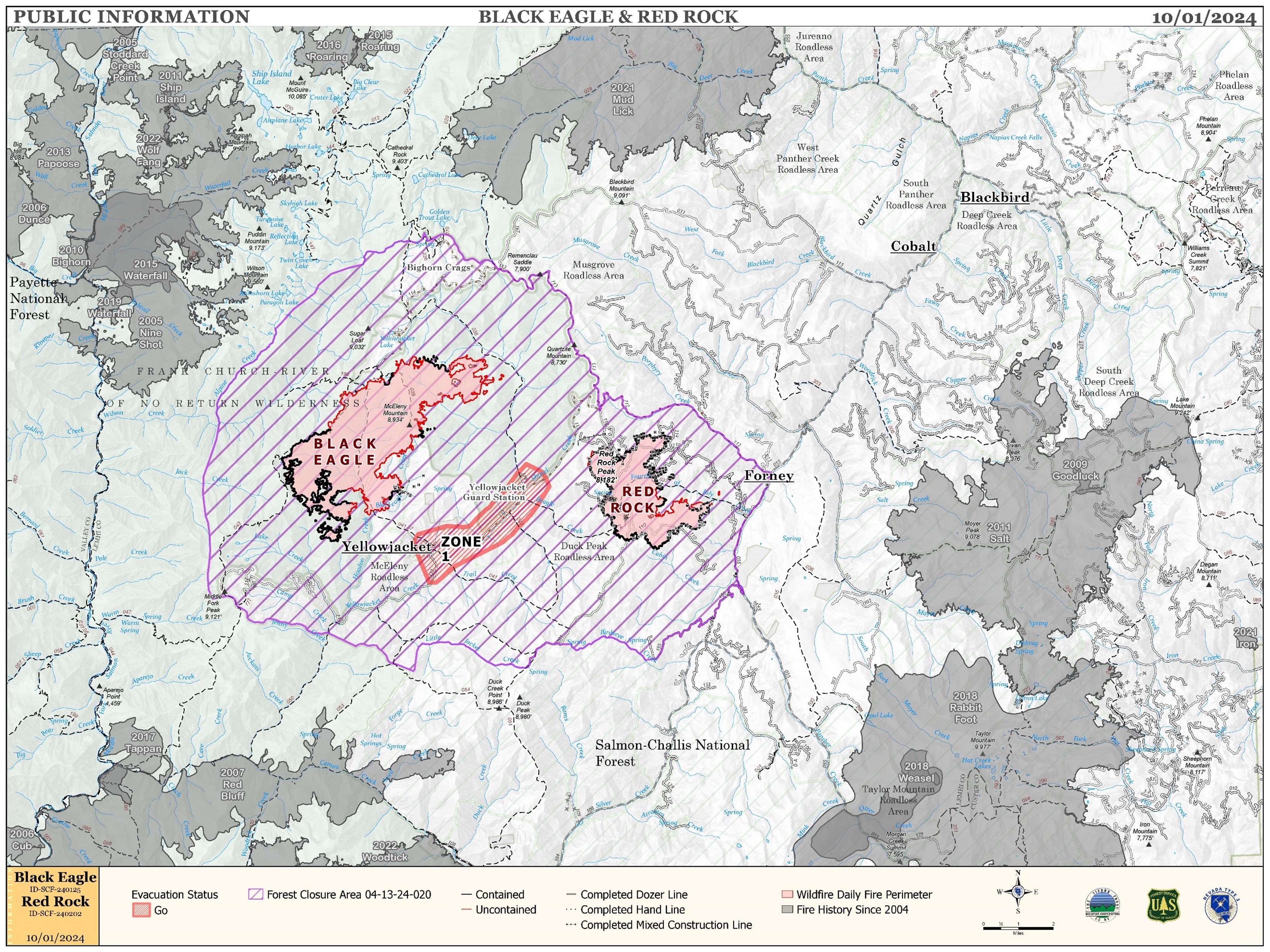
Red Rock and Black Eagle Fire Daily Update 10 01 2024
Related Incident:
Publication Type: News
IRE ACTIVITY:
The Red Rock Fire is at 3,367 acres and 75% containment.
Winds and fire activity moderated overnight with cooler temperatures. The majority of the fire faired very well through Sunday’s high winds; only the northeast side of the fire saw increased growth. The fire burning in the 4th of July drainage still poses control issues due to poor access and unsafe conditions for direct attack. Firefighters are building indirect line ahead of the fire to catch the fire if and when it crosses the drainage.
The Black Eagle Fire is at 7,433 acres and 8% containment.
The Black Eagle Fire saw considerable growth over Sunday’s wind event but nearly all of the added acres were in designated wilderness areas. The division outside of the wilderness is still under a full suppression strategy but areas are also difficult to access safely and indirect attack must be used to control the fire. Aircraft are still supporting both fires with bucket work to slow its progression and cool flare ups to avoid spot fires.
WEATHER:
A weak ridge of high pressure will build over the area today. The winds will remain westerly but increase slightly over yesterday. Much warmer temperatures today with high temperatures 13 degrees warmer than Monday. Slightly higher humidity, but still unseasonably dry for this time of year. A weak system in the north will move through Wednesday bumping winds up slightly. A stronger, but dry, system will move over the area Friday night.
FIRE BEHAVIOR:
Nearly all fuels are available across both fires, though heavy dead and down fuels remain most problematic for firefighters. Areas where humidities fall below 25% with gusty afternoon winds can experience increased activity, including short-range spotting. Opportunities to attack the fire directly will likely be confined to morning hours and when effective water support is available.
FOREST CLOSURES: For forest closure information please go to: https://www.fs.usda.gov/alerts/scnf/alerts-notices
EVACUATIONS: For evacuation information in Lemhi County regarding these fires please go to: Emergency Management Department | Lemhi County, ID (lemhicountyidaho.org).
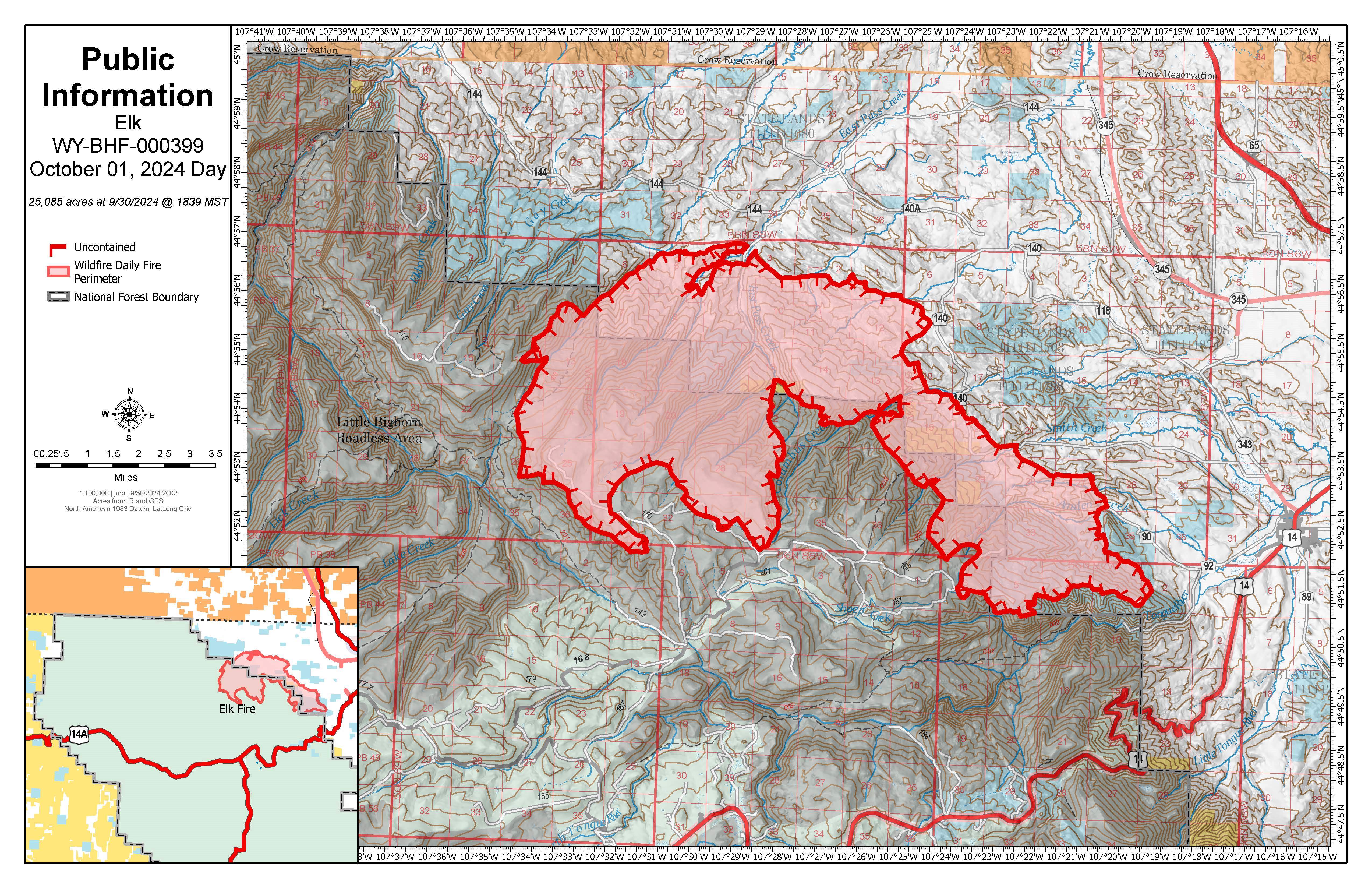
Elk Fire Daily Update Tuesday October 1 202410 01 2024
Related Incident: Elk Fire 2024
Publication Type: News
Wyoming Type 3 Team, Incident Commander: Matt Weakland
Location: Approximately 6 miles northwest of Dayton, Wyoming
Start Date: Friday, September 27, 2024
Cause: Lightning
Size: 25,085
Percent contained: 0%
Resources: 6 Hand Crews, 3 Engines, 4 Heavy Equipment, 2 type 1 Helicopters, 1 type 2 Helicopter, 1 type 3 Helicopter, 2 air attack, and air tankers as needed. Additional resources have been ordered.
KEY MESSAGES:
US Highway 14 remains closed from Dayton to Burgess Junction. Additionally, Sheridan County has closed Pass Creek Road, Twin Creek, Smith Creek Road, and Tongue River Canyon Road. Evacuations remain in place; please contact the Sheridan County Sheriff’s Office at 307-752-3455 or Sheridan County Emergency Management at 307-752-2174 for more information.
Management of the Elk Fire will transition from the Wyoming Type 3 Team to the Rocky Mountain Complex Incident Management Team 3 this evening. Complex Incident Management teams are brought into incidents to provide additional command and control capabilities to assist local units and communities during incidents such as the Elk Fire.
FIRE STATUS:
Yesterday, firefighting operations focused on the northern and eastern sides of the fire with crews working to remove vegetation by use of hand tools and strategically putting fire on the ground to consume vegetation, or fuel, between structures and the fire. Air resources were used to assist ground operations and ensure for firefighter safety.
Today, firefighters will continue to build fire line around the fire, where it is safe to do so, with the assistance of air resources. The strategy being implemented on this fire is full suppression. Firefighter and public safety remain the top priority, and the tactics used to suppress the fire will be determined by the terrain, fire and weather conditions, and medical response time.
CLOSURES:
A Bighorn National Forest Closure Order is in place for firefighter and public safety. The area closed is the area north of US Highway 14 and east of the border of the Medicine Wheel Ranger District and the Tongue Ranger District.
WEATHER AND FIRE BEHAVIOR:
Temperatures are expected to be in the mid-60s on the fire area today with winds changing to be out of the southwest and relative humidity around 18%. The shift in wind may cause the fire to be active in different areas than yesterday.
AIR QUALITY AND SMOKE:
It is expected that the fire will continue to put up a smoke column, please check the AirNow website at https://www.airnow.gov/ to monitor smoke movement.
Morning Update Frog Fire Tuesday 10 01 2024
Related Incident: Frog
Publication Type: News
Frog Fire Statistics
- Size: 3,114 acres
- Containment: 69%
- Total Personnel: 81
- Location: east of Clayton, ID
- Reported: September 7, 2024
- Cause: Lightning
For More Information
InciWeb: https://inciweb.wildfire.gov/incident-information/idstf-frog
Facebook: https://www.facebook.com/sawtoothnationalforest
Current Situation: Crews assigned to the Frog Fire had another day of good progress; containment was added to the north edge. The next few days will be spent ensuring containment lines are secure and any active fire near the perimeter is extinguished. Today, most crews and resources will be reassigned to the Wapiti or other fires in the area and the current camp on Big Boulder Creek will be dismantled. Minimal staffing will remain on the Frog Fire to make sure containment holds.
Evacuations: There are currently no evacuations related to the Frog Fire.
Closures: The area closure in place around the Frog Fire includes FS 667 (Big Boulder Creek Road) and Trail 047 where adjacent to the closure boundary. The closure excludes FS Roads 669 and 670 and Trail 682. Hunters and recreationalists should familiarize themselves with this closure information prior to entering the vicinity. Please reference the map and read the full closure description at https://inciweb.wildfire.gov/incident-closures/idstf-frog.
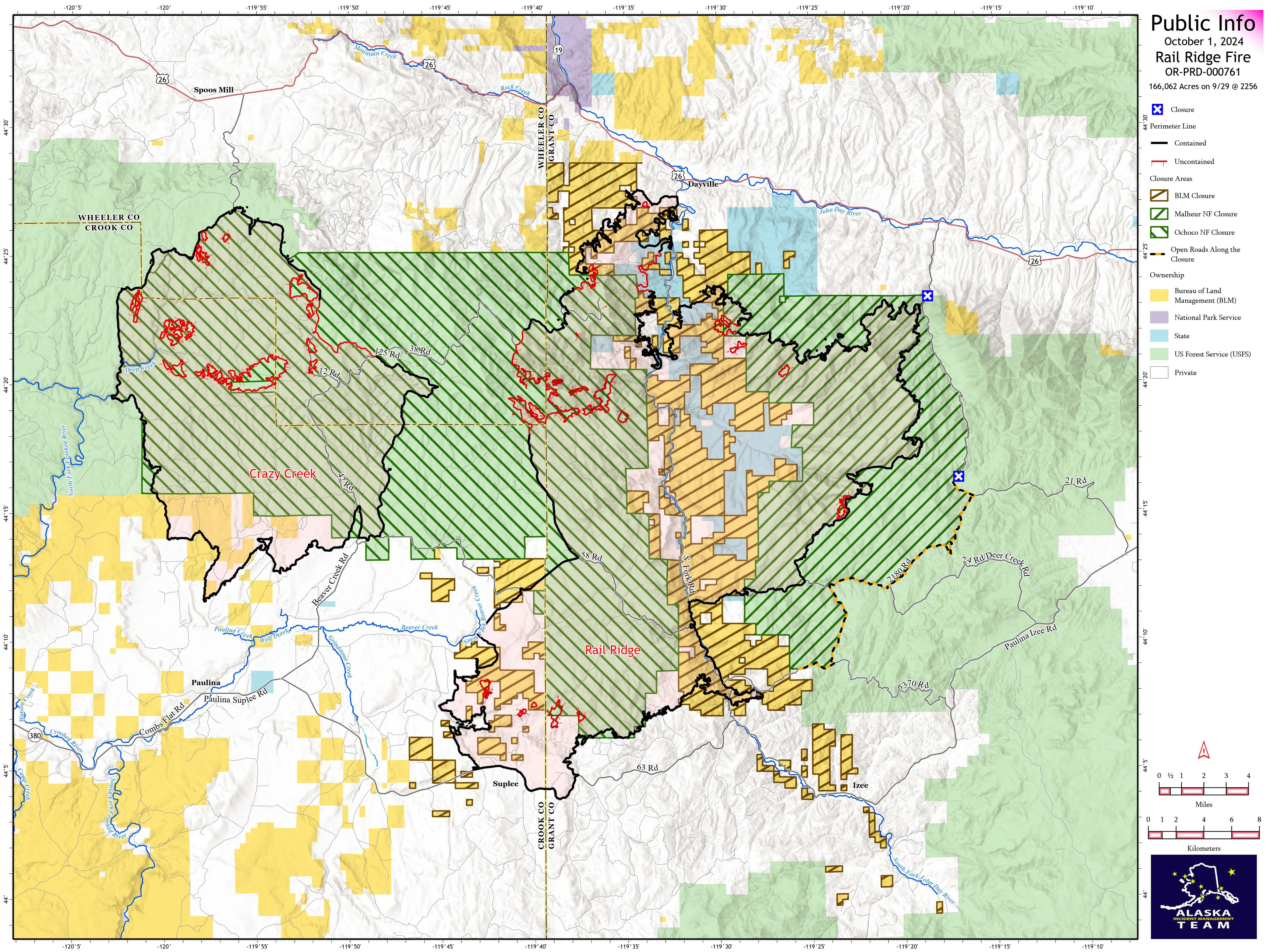
Rail Ridge Fire Daily Update 10 01 2024
Related Incident:
Publication Type: News
Rail Ridge Fire
Acres: 166,062 – Containment: 82% – Detection: 09/02/24 – Cause: Lightning – Personnel: 912
Operational Update
Yesterday’s weather gave a slight reprieve to firefighters in terms of fire behavior. Cooler temps and lighter winds gave crews on the ground an opportunity to use tactical burning operations in a defensive move to build a more robust “catcher’s mitt” in front of the fire on the south side of the Black Canyon Wilderness). Today’s critically dry weather may bring an uptick in fire behavior but is not anticipated to pose a threat to containment lines.
In the northwest corner of the fire where growth has increased in recent days, firefighting efforts have proven effective and containment lines have held for the past two shifts despite challenging winds and dry, hot weather. In the other northern part of the fire, firefighters gained more containment yesterday, while the work to locate and suppress hot spots is ongoing. In the southern end of the fire, repairs are being made to roads and dozer lines and hazard trees are being felled anywhere that may pose a threat to firefighters or the public.
Weather
The concerning dry trend continues today, with relative humidity possibly dipping into the single digits. Temperatures will get into the 70’s today. Winds will be from the southwest but will be light and terrain driven.
Evacuations
Rail Ridge Evacuations: Level 1 and 2 evacuation zones for the Rail Ridge Fire remain in Grant County.
For Current Evacuation Levels all affected counties, please visit: https://linktr.ee/RailRidgeFire
Closures: The U.S. Forest Service and Bureau of Land Management have implemented closures for the Rail Ridge Fire. For more details and closure maps, visit https://linktr.ee/RailRidgeFire

Morning Update Wapiti Fire Tuesday 10 01 2024
Related Incident:
Publication Type: News
Wapiti Fire Statistics
- Size: 125,624 acres
- Completion: 77%
- Total Personnel: 329
- Location: near Grandjean, ID
- Reported: July 24, 2024
- Cause: Lightning
For More Information
InciWeb: https://inciweb.wildfire.gov/incident-information/idbof-wapiti-fire
Facebook: https://www.facebook.com/wapitifireinfo2024
Linktree: https://linktr.ee/WapitiFireInfo2024
Interactive Map: https://tinyurl.com/WapitiFireInfoMap
Special Emphasis: Fire personnel saw fire activity on the Corral Fire yesterday during their daily observation flight of the area but do not anticipate significant potential growth since it is near rocky outcroppings that will limit fire spread. The fire has shown no sign of smoke in about 12 days. Fire managers will continue to keep an eye on this increase in activity.
There will be a temporary closure of Highway 21 around mile marker 126 today at 11 a.m. to allow removal of heavy equipment used for tree felling. The closure is expected to last less than an hour.
Collection of firewood within the closure areas is prohibited; any firewood collection in open areas must be done with a valid firewood permit. For questions on firewood collection on the Sawtooth National Forest, please contact the Stanley Ranger Station at 208.774.3000.
Weather: Winds in the fire area yesterday were calmer with very low humidity around or below 5%. Weather today will be similar with warm temperatures and gusts around 10-15 miles per hour picking up in the afternoon. Another cold front is predicted to move through Wednesday but brings no major concerns about increasing fire activity.
Current Situation: Crews added containment to the north part of the Wapiti Fire around Cape Horn. Some heat remains around Copper Mountain, Iron Creek, Big Meadows, and parts of the interior. Firefighters were able to secure most of the spots near Iron Creek yesterday and will continue to suppress fire activity near the perimeter and keep an eye on spots in the interior that are too dangerous to engage with directly. Patrols of the Highway 21 corridor will continue to ensure that containment lines are holding and to quickly respond to any increased fire activity.
Hazard tree removal was completed along Road 630 yesterday and is anticipated to be completed north of Valley Creek within the next shift. The progress made in the past few days has allowed crews to move from areas of low fire activity to assist with suppression and repair. The Idaho Transportation Department crews have made good progress installing guardrails along Highway 21.
Maps for the Wapiti Fire have been updated to better reflect the difference between containment lines and completion lines, since both strategies are in use on the fire area. Containment will continue to be shown as a black line along the fire perimeter; confinement will be shown as a brown line adjacent to the fire perimeter line.
Evacuations: Evacuation status for Stanley Zone 1 is currently at READY. Stanley Zones 2 – 5 and Kasino are no longer in an evacuation status. Sign up for Custer County CodeRED emergency notifications: text CUSTER to 99411 or enroll at https://public.coderedweb.com/CNE/BF28E45537FF.
All Boise County evacuation levels have been lifted; residents should remain alert for any change in conditions which could reinitiate an evacuation status. Sign up for Boise County Alert Sense emergency notifications at https://public.alertsense.com/SignUp/publicUser.aspx?regionid=1163.
For evacuation information on the Wapiti Fire, please see the Custer County Sheriff’s Facebook page, https://www.facebook.com/p/Custer-County-Sheriff-Idaho-61558947312289/, and the Boise County Sheriff’s Facebook page, https://www.facebook.com/boisecountysheriff/.
Closures: The Wapiti Fire area closure covers portions of the Sawtooth, Boise, and Salmon-Challis National Forests. Please reference the map and description at https://inciweb.wildfire.gov/incident-closures/idbof-wapiti-fire. Recreationalists and hunters should reference this map and obey all posted signage regarding the closure area and any related road, trail, and campground closures. Fire managers and local forest officials are evaluating the current closure area for a reduction in size and scope once it is safe to do so.
An interactive map for all closures on the Boise National Forest is found at https://experience.arcgis.com/experience/642380b0eb124c8cab6bd9ad3d7146ad/page/Overview/#data_s=id%3AdataSource_5-1888bd00a2c-layer-13-1888bd00b53-layer-16%3A82.
Daily Update Lava Fire October 1 2024 10 01 2024
Related Incident:
Publication Type: News
Current Situation:
- The Lava Fire is 84% contained at 97,625 acres, with 541 personnel assigned.
- Crews are continuing to remove unneeded pumps, hoses, and other equipment from the southeast corner of the fire to return to the cache.
- Firefighters, including two Interagency Hotshot Crews, are continuing to secure several small spot fires in steep terrain along the east and northeast side of the fire.
- Firefighters are now monitoring line near Anderson Creek on the northern edge of the fire to ensure no hot spots remain.
- On the Forest Road 653, north of Sage Hen Reservoir, continuing Unmanned Aerial System (UAS) use allows crews to find and pinpoint hotspots, accelerating firefighter work in the tall and dense brush.
Weather: Yesterday was cool and dry due to a cold front moving through the area. Today, conditions are warming and remaining dry. Warm and dry conditions are expected to persist this week, however fire behavior should remain minimal.
Evacuations: A Level 1 “READY” notice remains for residents south of South Grays Creek, along Little Weiser River Road in Indian Valley, North of South Grays Creek Road to Highway 95, and the Mesa Area. https://www.gemcounty.org/departments_offices/latest_advisories_watch_warnings.php
Valley County Sheriff’s Office has removed Zones 2 & 3 from LEVEL 1 “READY” status. Zones 4 – 6 remain in a LEVEL 1 “READY” status. https://www.co.valley.id.us/departments/Wildfire/WildfireEvacuation
Closures: The Boise and Payette National Forests have adjusted the Lava Fire area closure yesterday, increasing access for the public to select areas north and south of the fire perimeter. For updated map and closure information see: *CLOSURE AREAS... - U.S. Forest Service - Boise National Forest | Facebook.
Gem County Road and Bridge issued the following road closures: Third Fork Road at Nesbitt Lane, Second Fork Road at Nesbitt Lane, and Nesbitt Lane. Check out updated closure information at https://gemcounty.org/departments_offices/latest_advisories_watch_warnings.php
Temporary Flight Restrictions:A temporary flight restriction (TFR) is in effect. View a map of the TFR and details at https://tfr.faa.gov/save_pages/detail_4_8199.html. Fire aviation response is halted or delayed if an unauthorized aircraft enters the TFR. Temporary flight restrictions also apply to unmanned aircraft systems or drones. If you fly, we can’t! Learn more about how to use drones safely and responsibly at Home - Know Before You Fly.
Fire Info Phone: 208-780-5003 Hours: 7:00 a.m. to 7:00 p.m. Email: 2024.Lava@firenet.gov
Facebook:@LavaFire Inciweb: inciweb.wildfire.gov/incident-information/idbof-lava-fire
_0.jpg?VersionId=xo4Wpg4nSEE2.W6hPNMral1IEB3PzXXU)
Willamette NF cancels Tire Mountain closure reduces Chalk Fire closure area 09 30 2024
Related Incident: Willamette Complex Fires - South
Publication Type: Announcement
Willamette NF cancels Tire Mountain Fire closure, reduces Chalk Fire closure area
Ollalie Trailhead, Kiahanie Campground among rec sites to reopen
Springfield, Ore. – Sept. 30, 2024 – The Willamette National Forest will cancel the Tire Mountain Fire Closure Order (06-18-10-24-18) and reduce the Chalk Fire closure area on Oct. 1, 2024, reopening many popular recreation sites in the Middle Fork Ranger District.
The lightning-caused Chalk Fire, located north of Oakridge, is 6,006 acres and 100% contained. The Tire Mountain, Coffee Pot, and McKinley Creek fires also are 100% contained.
“While we still have work to do this fire season, we are committed to keeping the closure areas as small as possible,” said Acting Middle Fork District Ranger Cameron Mitchell. “We will continue to reduce closures as soon as we can while providing for the safety of the public and our responders out there performing critical work.”
Approximately 20 miles of Forest Service Road (FSR) 19, also known as Aufderheide Drive, will reopen, restoring access to Rebel Creek Trailhead, Ollalie Trailhead, and Roaring River Trailhead from the north. FSR 1910 and FSR 1928 are also now open for travel.
A portion of the FSR 19 is still closed between the junctions of FSR 1912 and FSR 1928 (milepost 5-14). The best way to access this area is by going up FSR 1928 and over High Prairie to where it connects with FSR 1900.
Recreation sites and trails that are now open include Huckleberry Flats OHV Area east of FSR 1928, Kiahanie Campground, and Alpine Trail #3450 (accessible from FSR 1910).
Recreation sites that remain closed include Huckleberry Flats OHV Area west of FSR 1928, North Fork Segment #2 Trail #3666.2 and Trailhead, and North Fork Segment #3.
For a map of the closure area and a complete list of recreation sites and roads included in the order, visit our website at https://www.fs.usda.gov/alerts/willamette/alerts-notices.
Follow us on Facebook and X @WillametteNF for the latest updates.