
Daily Update for Lionshead Fire Saturday September 26
Related Incident:
Publication Type: News
Lionshead Fire Update – Saturday, September 26, 2020 - 10 a.m.
More Winds Test Control Lines
Special Notice: The Rocky Mountain Incident Management Team shared a pre-recorded Public Meeting message to discuss the fire situation and evacuation level changes in Marion County.The recording is available on Facebook (https://www.facebook.com/events/1383001042049433/ ).
Current Situation: Friday brought quite a bit of rain to the west side of the fire. This raised fuel moisture and helped reduce the immediate danger of additional spread in that area. The east side received spotty precipitation and gusty southwest winds. Fuel moistures on the east side of the crest remain somewhat lower. The wind and dry fuels have resulted in some fire activity in green islands within the fire perimeter. These islands may put up smoke during expected windy conditions today. Building high pressure could bring east winds to the fire area today, testing control lines throughout.
The high winds yesterday tested some areas of the fire that had been inactive. Other than interior burning, the fire showed minimal spread. In some areas, crews disengaged from their work to avoid the possibility of hazard trees falling due to windy conditions.
Firefighting Efforts by Division: (Refer to the map for division breakdown.)
Very little movement has occurred on the north edge of the fire in Division A over the past few days. High winds slowed firefighting activity due to hazard tree safety concerns. As weather allows, firefighters will continue their work to secure the fire's edge and reinforce the contingency line to the north.
Division E is in monitor and patrol status. Mop up operations continue in this division.
In Division R the fire is still hung up in the lava fields but is not spreading. Patrol of this area and planning for future efforts occurred Friday. The contingency line on Road 12 is done. Hazard tree removal continues.
In Division S and T, the damp conditions have allowed for more direct line construction and mop up.
Structure group worked in the Detroit area assessing structures and roads. Residents were allowed to travel to and from the Detroit area on Friday under pilot car escort.
Division W is being monitored by air and from lookouts. Coordination with Beachie and Riverside fire operations continues in Division Y. The long finger of fire and associated spot fires are being directly addressed and are close to being secured. A hard closure will be maintained on Road 46 due to hazard trees in that corridors.
Some direct actions and chipping operations continue in Division Z. High winds slowed productivity.
Weather and Fuels Conditions: A high pressure system could bring easterly winds along ridges. High winds with moderate temperatures and lower humidity continue. Expect some interior burning. Light rain is possible today on parts of the fire. A slow warming trend is forecast but some showers should linger through Sunday. Monday is forecast to be drier and warmer. Good air quality is expected today and tomorrow throughout the area.
Closures and Evacuations: Evacuation levels changed in Marion County yesterday. The evacuation levels around Detroit, Idanha, and the Elkhorn community along North Fork Road are being reduced to a Level 2 - "Be Set" evacuation level. While residents will be able to return to these communities under strict safety conditions, many hazards remain. Due to the remaining hazards in the cities of Detroit and Idanha and lack of basic services, we request people who are not residents should avoid traveling to this area. The Marion County Sheriff's Office continues to coordinate with partner law enforcement agencies to maintain an enhanced presence in the Detroit and Idanha communities as residents return.
Community members who happen to reside in Linn County may find up to date information at www.LinnSheriff.org .
A map of evacuations in Marion County are available on their website linked here:
https://marioncounty.maps.arcgis.com/apps/webappviewer/index.html?id=5202b602f99647b9a16d488c545113b5&fbclid=IwAR3IWTUcLAF14aB3R-p7v124S3ZLr2j0bTs_Prr16CCJnWkxF9s1RCUffKo .There are no longer evacuation notices for the Sidwalter/Miller flats area.
Roads and trails near the fires remain closed for public safety. The 12 Road and the 46 Road will remain closed to the public for the near future. This includes roads and trails on the Confederated Tribes of Warm Spring lands adjacent to the fire and a 40-mile section of the Pacific Crest Trail between Santiam Pass and Olallie Lake. The Willamette National Forest, Bureau of Land Management, and State lands around the fire remain closed to the public. Go to InciWeb.gov for more information about closures in the area. Forest closures are in place for Deschutes, Mt. Hood and Willamette National Forests: Deschutes NF Alerts Willamette NF Alerts Mt. Hood NF Alerts.
Temporary Flight Restrictions: A Temporary Flight Restriction is in place over the Lionshead Fire and surrounding fires. Wildfires are a No Drone Zone. If you fly, we can’t. Whenever a drone is spotted near the fire all aircraft are grounded until we can be sure the drone is clear of the area. For more information, visit knowbeforeyoufly.org.
Lionshead Fire Statistics:
Size: 204,340 acres
Containment: 28%
Total Personnel: 1,610
Location: 14 miles west of Warm Springs
Reported: 8/16/20, approximately 8:44 p.m.
Cause: Lightning
For More Information:
Information Office: 971-277-5075, 8 a.m. to 8 p.m.
Media Inquiries: 541-904-0542
Email: 2020.lionshead@firenet.gov
Inciweb: https://inciweb.nwcg.gov/incident/7049/
Facebook: www.facebook.com/LionsheadFire
Lionshead YouTube Channel: https://www.youtube.com/channel/UCHSR6_yJRQkHyGjvvqX99gw
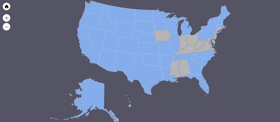
Fire Fighters Come from all over North America
Related Incident:
Publication Type: News
Did you know that often resources assisting on larger or longer duration fires are not always locals? Many of the teams and crews that come in to assist come from out of the area. This is a map highlighting all the states represented here on the
Oregon State Forest Lands Reopen
Related Incident:
Publication Type: Announcement
Most state forest lands re-open -
As of Friday, Sept. 25, all ODF-managed state forest land is open except for the Santiam State Forest and Land in Jackson and Josephine counties. Fire season is still in effect, so know public use restrictions in the area before you go.
Note that some closures related to COVID-19 pandemic remain in effect. Please visit the recreation list for COCVID-19 updates on the specific recreation sites by opening the attached article and clicking on the underlined text. This will lead you to the most up-to-date information on Oregon Department of Forestry information.
Portions of Mt Hood NF to Reopen Saturday
Related Incident:
Publication Type: News
NEWS RELEASE
Release date: September 25, 2020
North and east areas of Mt. Hood National Forest to reopen Saturday
Many forest areas that were closed following the historic Labor Day windstorm that brought down thousands of trees and propelled the Riverside Fire will reopen on Saturday, September 26 at 12:01 a.m. The forest suffered extensive and severe damage as a result of the storm so many areas will remain closed or are still blocked by trees.
On the west side of the forest, areas north of US Highway 26 will reopen. Land, roads, trails, and recreation sites south of Hwy 26 will remain closed due to widespread damage, debris slides, and the Riverside Fire, which is just under 140,000 acres in size and 34% contained. The closed area includes all of Clackamas River Ranger District and a portion of Zigzag Ranger District. The Timberline Trail, Pacific Crest Trail (Timberline to Town Trail), Top Spur Trail, Sandy River Trail (Ramona Falls), and other trails in the immediate vicinity of Mt. Hood, while not formally closed, are nearly impassable due to downed trees.
A few sites south of Hwy 26 will reopen. These closure exceptions are:
- Forest Road 2618 (Old Salmon River Road);
- Mirror Lake Trailhead;
- Trails within the Salmon-Huckleberry Wilderness;
- The following trails: Mirror Lake (#664), Salmon River (#742), Still Creek (#780), McIntyre Ridge (#782), Bonanza (#786), Hunchback (#793), Flag Mountain (#766), Salmon Butte (#791), Green Canyon Way (#793A), Cool Creek (#794)
On the east side of the forest Hood River Ranger District and Barlow Ranger District will reopen except for a fire closure area surrounding the White River Fire. The White River Fire is about 85% contained but is still burning on the interior of the fire and will likely have burning stumps and smoldering hot spots for many weeks.
All campgrounds on the forest have closed for the season, except for the following sites on the east side: Lost Lake, Laurance Lake, Sherwood, Nottingham, Eightmile, Lower Eightmile, Pebble Ford, Wahtum Lake, and Knebel Springs.
Campfires are still prohibited on the entire Mt. Hood National Forest due to high fire danger and ongoing active fires. Portable cooking stoves and lanterns using liquefied or bottled fuel (like propane) are allowed as they can be instantly switched off.
Downed trees and hanging limbs are still being cleaned up. Please use extreme caution when out on the forest, including looking up and around you to assess hazards. While driving, watch out for fallen trees and debris on the roadway, as well as limbs extending over the roadway.
Daily Update for Lionshead Fire Friday September 25
Related Incident:
Publication Type: News
Lionshead Fire Update – Friday, September 25, 2020 - 10 a.m.
Damp Weather & Hard Work Bring Increased Containment
Special Notice: The Rocky Mountain Incident Management Team will be sharing a pre-recorded Public Meeting message to discuss the fire situation and evacuation level changes in Marion County. Although it will be pre-recorded, we will have Information Officers to monitor and answer questions. The recording will be available mid-day on Facebook (https://www.facebook.com/events/1383001042049433/ ). Please see "Closures and Evacuations" section below links to detailed information about these changes.
Current Situation: The cold front that moved through the area yesterday brought rain to most of the fire. This slowed fire activity, but the east side of the fire dried out quickly with gusty southwest winds. Fuel moistures on the east side of the fire were still dropping Thursday afternoon. The wind and drying fuels resulted in some increased burning in green islands well within the fire's perimeter. These islands may put up smoke during expected windy conditions today. Another cold front will bring more damp weather to the fire area today.The combination of damp weather over most of the Lionshead fire and the continued hard work of the firefighters resulted in containment increasing to 28%.
Firefighting Efforts by Division: (Refer to the map for division breakdown.)
Very little movement has occurred on the north edge of the fire in Division A over the past few days. The contingency line north of the fire's active edge is secure. Plans are to go direct on the fire's edge when it is safe and productive to do so.
Division K, N, & R are being patrolled and mopped up. Some chipping operations are ongoing there. In the Jefferson Lake area, the fire is still hung up on the lava fields. The fire there has not spread in days.
In Division E, patrol and chipping operations continue.
In Division S and T, favorable weather conditions have allowed for direct line construction and mop up. New containment is noted on the map in this area. A hard closure will be maintained on Road 46 due to hazard trees.
Coordination with Beachie and Riverside fire operations over future plans for Division W continues. Spot fires in Division Z continue to be the focus of suppression efforts in this division.
Weather and Fuels Conditions: A strong cold front is arriving today with gusty winds along ridges and southwest drainages. Rain is expected to increase throughout the day. Temperatures will be somewhat cooler with high humidity. Saturday, a slow warming trend is forecast , but some showers may linger through Sunday. Monday is forecast to be drier and warmer. Good air quality is expected today and tomorrow throughout the area.
Closures and Evacuations: Today at 9 a.m. evacuation level changes will go into effect in Marion County. The changes are being made following careful consultation between fire management officials and the Oregon Department of Transportation, Marion County Public Works, law enforcement, and many other partner agencies.
The evacuation levels around Detroit, Idanha, and the Elkhorn community along North Fork Road are being reduced to a Level 2 - "Be Set" evacuation level at 9 a.m. Crews have been working tirelessly to restore access to evacuated areas. While residents will be able to return to these communities under strict safety conditions, many hazards remain. Core services have not yet been restored.
"As our residents return to the cities of Detroit and Idanha, we are asking the media and other visitors to be respectful of our community members during this difficult time," said City of Detroit Mayor Jim Trett. "This will be the first time many of our residents are seeing the extent of the damage following the wildfires. Please allow our residents an opportunity to grieve these losses privately."
Due to the remaining hazards in the cities of Detroit and Idanha and lack of basic services, we request people who are not residents to refrain from traveling to this area. The Marion County Sheriff's Office continues to coordinate with partner law enforcement agencies to maintain an enhanced presence in the Detroit and Idanha communities as residents return. Community members who happen to reside in Linn County may find up to date information at www.LinnSheriff.org .
A map of evacuations in Marion County are available on their website linked here:
https://marioncounty.maps.arcgis.com/apps/webappviewer/index.html?id=5202b602f99647b9a16d488c545113b5&fbclid=IwAR3IWTUcLAF14aB3R-p7v124S3ZLr2j0bTs_Prr16CCJnWkxF9s1RCUffKo .There are no longer evacuation notices for the Sidwalter/Miller flats area.
Roads and trails near the fires remain closed for public safety. The 12 Road and the 46 Road will remain closed to the public for the near future. This includes roads and trails on the Confederated Tribes of Warm Spring lands adjacent to the fire and a 40-mile section of the Pacific Crest Trail between Santiam Pass and Olallie Lake. The Willamette National Forest, Bureau of Land Management, and State lands around the fire remain closed to the public. Go to InciWeb.gov for more information about closures in the area. Forest closures are in place for Deschutes, Mt. Hood and Willamette National Forests: Deschutes NF Alerts Willamette NF Alerts Mt. Hood NF Alerts.
Temporary Flight Restrictions: A Temporary Flight Restriction is in place over the Lionshead Fire and surrounding fires. Wildfires are a No Drone Zone. If you fly, we can’t. Whenever a drone is spotted near the fire all aircraft are grounded until we can be sure the drone is clear of the area. For more information, visit knowbeforeyoufly.org.
Lionshead Fire Statistics:
Size: 204,250 acres
Containment: 28%
Total Personnel: 1,515
Location: 14 miles west of Warm Springs
Reported: 8/16/20, approximately 8:44 p.m.
Cause: Lightning
For More Information:
Information Office: 971-277-5075, 8 a.m. to 8 p.m.
Media Inquiries: 541-904-0542
Email: 2020.lionshead@firenet.gov
Inciweb: https://inciweb.nwcg.gov/incident/7049/
Facebook: www.facebook.com/LionsheadFire
Lionshead YouTube Channel: https://www.youtube.com/channel/UCHSR6_yJRQkHyGjvvqX99gw
Air Quality and Smoke Reports for September 25
Related Incident:
Publication Type: News
We are expected another day of unsettled weather due to the passage of a cold front moving in from the west. Expect windy conditions today and rain beginning in the afternoon. Rain amounts could total over 3/4" today and overnight.
Good air quality expected today and tomorrow throughout the forecast area.
Lionshead Fire Containment Grows but the Hazards Remain
Related Incident:
Publication Type: News
Thanks to the hard work from the firefighters, as well as some help with the weather, the
As containment slowly increases, the public may wonder why some closures or evacuations remain in place, and why they are not able to return home. We sympathize with those who have been affected by these fires. However, it's important to note that containment does not mean a fire is out, or that the danger has passed. The containment percentage ...refers to the perimeter of the fire, and doesn’t correlate to safety level within the fire perimeter. The fire itself may still burn within the interior for many weeks. We want the public to know that we are working diligently to make the areas safe for owners to repopulate, but it takes a thorough cooperative effort to do so
First and foremost, fire managers must assure the areas are contained, secured and safe from fire. Pockets of heat can remain, even months after a fire has passed. Crews are combing these areas diligently to eliminate any potential hazards and hot spots, both for the danger they pose to the public, as well as the possibility of them to reignite. Firefighters are working to cut down hazardous trees, and crews are working to open and clear roads for accessibility. The utility companies are coordinating with fire managers to fix dangerous downed power lines, check the water quality, and assure the area is safe from other potential dangers. The Sheriffs must complete their assessments of structures and infrastructure as well.
Once all parties have confirmed the area is safe for repopulation, the Sheriff will make announcements when they are able to repopulate. Thank you for your patience as we work diligently together to make your communities safe for return.
Public Meeting tomorrow will be recorded and shared about 1200 on Sept 25
Related Incident:
Publication Type: Announcement
Prerecorded Information meeting for the public will be shared approximately 12:00 Friday, September 25
The Rocky Mountain IMT will be recording a meeting tomorrow at 11:00 and then shared immediately afterwards (approximately 12:00). The meeting will give updates on evacuation changes, current situation on the fire and other updates. Facebook will be one of the easiest ways to view the video of this meeting. The link to Facebook is www.facebook.com/LionsheadFire
It will also be added here on Inciweb.
You Tube and Facebook have the Daily Ops Videos
Related Incident:
Publication Type: Announcement
Here are the links to the daily operations videos that describe the current status of the fire and the plan for the day.
Facebook: https://www.facebook.com/LionsheadFire
YouTube:https://www.youtube.com/channel/UCHSR6_yJRQkHyGjvvqX99gw
You can also see past videos too.