
Willamette National Forest updates Lionshead Closure Area
Related Incident:
Publication Type: Closures
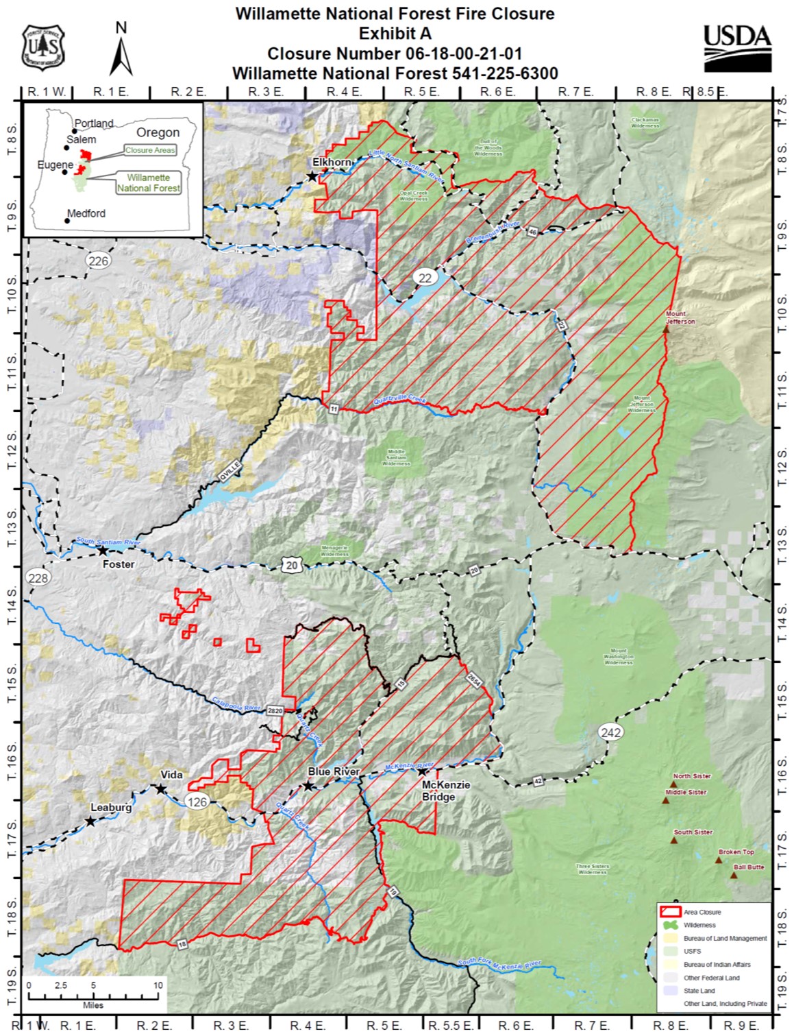
Please see the updated closure map for lands on the Willamette National Forest. We realize this is a large area closure but impacts from the fires over the last month have been far reaching. The closure is in place for public safety and to allow firefighters room to accomplish a variety of tasks such as fire line repair and hazard tree mitigation. Due to the nature of the fires, some areas will likely be closed through the winter, or even longer term. Other areas will open as soon as its safe. Please “know before you go” and check the latest closure information before heading out. Thank you for your patience.
Lionshead Fire update for Friday Oct 9
Related Incident:
Publication Type: News
Lionshead Fire update for Friday, Oct. 9
REDMOND, Ore. – Much of the repair and rehabilitation work firefighters and resource advisors (READs) being done this week has focused on stabilizing and protecting areas of the burn zone against the incoming rains.
Mitigation measures on steep slopes have been prioritized to reduce erosion, particularly in the form of dozer line repair. This work includes loosening soils compacted by heavy equipment to increase absorption; redistributing berms of soil and vegetative material scraped away when bulldozers were cutting line; and creating water bars, which channel water into ditches or unburned green areas.
Thursday, Prineville Hotshots helped guide strategic water drops on a spot fire near the finger to the north. Water drops continued on Mt. Bruno as well.
A contingency line to the north that will benefit both the Lionshead and Riverside fire responses is nearly complete. Hazard tree falling on the Hwy. 46 corridor is nearly complete. Interior burning in the northeast corner was more subdued, but incoming winds could stimulate more activity today as a new weather front moves into the region.
Weather: Abundant rain is expected Saturday, Incident Meteorologist Chuck Redman said, estimating up to 2 inches of rain could fall on the west side of the Cascade Crest, with ½ to ¾ of an inch on the east side.
“We’re looking at a good thread of wetting rain throughout the weekend,” Redman, said, adding showers should continue into Monday morning.
Safety: Rain is good news for suppression, but also poses additional hazards that can put firefighters at risk. Depending on conditions, crews may have to stop work and seek shelter at times.
Many of the hazards firefighters face also apply to communities where residents and landowners have been allowed to return, and also areas reopened to recreation and hunting.
Strong winds can topple trees and cause limbs to fall, while heavy rain can limit visibility, destabilize rocks, logs and trees on slopes, wash out roads and cause mudslides or flash flooding. Cooler temperatures and wet conditions can also lead to hypothermia.
Closures: Closure orders and maps for the Willamette, Mt. Hood and Deschutes National Forests and Prineville District Bureau of Land Management can be found at https://inciweb.nwcg.gov/incident/7049/ Oregon Department of Fish and Wildlife has updated hunting information can be found at https://myodfw.com/articles/2020-wildfires-impact-hunting-fishing-wildlife
Lionshead Update Stahlman residents may now access property Oct 8 2020
Related Incident:
Publication Type: Announcement
Stahlman residents may now access property
REDMOND, Ore. – Stahlman Cabins and Sportsmen Club residents and property owners are now free to re-enter the community, as the Linn County Sheriff’s Office has downgraded the evacuation level to 2 – Be Ready.
Evacuees returning to their communities should remain alert, as many hazards remain. Soils may be unstable; ash can camouflage trip holes and trip hazards; hot embers may still be smoldering in stumps, roots and holes; and trees and branches weakened by fire can fall at any time.
Property owners are advised to stay within the footprint of their cabin property and on roadways, as hazard removal has not been performed outside of those areas.
Increased winds and rain in the coming days could bring additional hazards, including destabilizing previously stable ground, toppling more trees, mudslides and flash flooding.
For complete details, please visit https://www.linnsheriff.org/
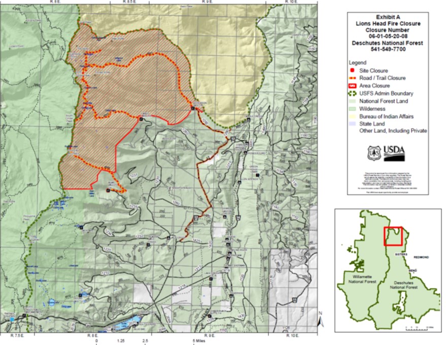
Lionshead Fire Closure Information Map October 8 2020
Related Incident:
Publication Type: Announcement
Lionshead Fire Closure Information Map October 8, 2020
Lionshead Fire Update for October 8 2020
Related Incident:
Publication Type: News
Lionshead Fire update for Thursday, Oct. 8
REDMOND, Ore. – Aviation support is helping cool and slow the progression of hotspots around Mt. Bruno and a spot fire on the finger to the north while firefighters carry on with the many details of repair and rehabilitation.
Before an incident management team embarks on the repair and rehabilitation phase of a fire, the agencies affected provide written standards for the level of work to be performed. While many standards are universal, others set guidelines for specific values.
For the Willamette and Mt. Hood National Forests, there are added standards for visual mitigation along the West Cascades Scenic Byway, including minimizing stump height, following natural contours where feasible, leaving 3 to 5 down trees per acre, leaving clumps of small diameter trees where they do not pose a hazard to the roadway. These same standards apply to the Olallie Lake viewshed on the MHNF.
Today, the structure group will be removing protective aluminized wrapping from Gold Butte Lookout.
Weather: Wednesday’s winds drew smoke from the California wildfires into the area, which could settle into the valleys today. A cold front moving in from Canada will lower temperatures into in the 50s and 60s, with higher humidity levels and 20 percent chance of precipitation. Winds could gust up to 23 mph.
Closures: Deschutes National Forest officials have reduced the Lionshead Fire Closure area, reopening some popular locations on the Sisters Ranger District. The public can now access to Round Lake, Jack Lake Trailhead and Jack Creek, as well as the southern portion of the Mt. Jefferson Wilderness.
Due to continued fire activity, the Mt. Jefferson Wilderness remains closed north of Minto Lake, which includes entry from Bear Valley, Cabot Lake and Jefferson Lake Trailheads. Forest Service Road (FSR) 12 remains closed between the junction with FSR 1425 north to the junction with FSR 1290 as firefighters continue active fire suppression and suppression repair activities. FSR 1290 and 1292 also remain closed.
The southern half of Mt. Hood National Forest is closed, however, the forest has reopened a large area on the east side. Complete details can be found at https://www.fs.usda.gov/detail/mthood/news-events/?cid=FSEPRD811247
Hunters and others wanting to recreate should watch for fire traffic on highways and secondary roads, and also be aware the Sept. 7 wind event also left many downed trees and other hazards in areas not affected by the fire. Incoming wind and rain could cause stressed trees and branches to fall in the coming days.
Evacuations: Evacuation levels remain unchanged for the communities on the west side of the fire. More information can be found at https://inciweb.nwcg.gov/incident/closures/7049/
Deschutes National Forest Officials Further Decrease Lionshead Fire Closure
Related Incident:
Publication Type: Announcement
Revised closure allows increased access for hunting and recreation on Sisters Ranger District. See attached map and News Release below.
Lionshead Fire update for Wednesday Oct 7
Related Incident:
Publication Type: News
Lionshead Fire update for Wednesday, Oct. 7
REDMOND, Ore. – As additional portions of line are secured each day, more resources are focusing on removing hazard trees and slash, removing equipment from the fire line and conducting suppression repair work.
“Little things add up to big successes in terms of our tactical and strategic goals for the fire,” said John Spencer, operations chief trainee.
Planning is under way to escort residents of the Stahlman Cabins and Sportsman Club into the area to retrieve belongings. In other work, Resource Advisors (READs) coordinated with engineers to develop a plan that will allow loggers to retrieve equipment from three harvest plots located in the interior of the fire.
Tuesday, crews finished clearing hazard trees and fire debris from around Detroit’s water treatment site and the intake from Breitenbush Creek, making it safe for work to resume.
Two helicopters dropped 72,000 gallons of water on Mt. Bruno and in the fire finger to the north. READs from Mt. Hood National Forest conducted a survey of Bull trout – which are listed as a threatened species along Pinhead Creek.
As resources move around the fire to work in different areas, firefighters take care to prevent the transfer of non-native or potentially invasive species. For example, crews take care to clean their boots and pressure wash the undercarriages of equipment and vehicles to remove plants and seeds. Pumps, hoses and fish screens are also sanitized. Helicopter buckets are cleaned and sanitized before they begin dipping out of a new water source.
Weather: Winds are expected to pick up today and also change from a southeast-west trajectory to a southwest-west path. Temperatures will be in the 60s and 70s, then start tapering off to the low 50s by Saturday. Significant rain is expected west of the Cascade Crest, with typically lighter rainfall on the east side of the fire zone.
Closures: Most fire area closures remain in effect, but the vast majority of public lands managed by the USDA Forest Service and Bureau of Land Management that were closed as a precautionary action during the period of high potential for fire starts and rapid growth have reopened.
Hunters can visit https://myodfw.com/articles/2020-wildfires-impact-hunting-fishing-wildlife for information about hunt status, unit accessibility and more.
Weather: Winds are expected to pick up today and also change from a southeast-west trajectory to a southwest-west path. Temperatures will be in the 80s, then start tapering off to the low 50s by Saturday.
Evacuations: Evacuation levels remain unchanged for the communities on the west side of the fire. More information can be found at https://inciweb.nwcg.gov/incident/closures/7049/
Deschutes National Forest Summer Trail Access Update Sept30 to Oct14
Related Incident:
Publication Type: Announcement
SUMMER TRAIL ACCESS AND CONDITION UPDATE
SEPTEMBER 30 TO OCTOBER 14, 2020
Summer Trail Highlights
SEVERAL TRAIL AND AREA CLOSURES are in effect due to wildfires. These include the Pacific Crest, Green
Ridge and all of the trails within the Mt Jefferson Wilderness. See inside for more details.
All Deschutes National Forest trails are snow free.
Recent wind storms have brought down trees on many area trails. Visitors should anticipate them on the trail, as removal efforts will be limited. The reports below represent the best of our knowledge.
Fire danger is EXTREME and there is a FULL CAMPFIRE BAN in effect. The only open flame that is allowed on the forest is from a gas stove for the purpose of preparing food.
Day use fees are now required at most developed recreation sites. Follow posted instructions. Until further notice, no Wilderness permits are required.
- Motorized bicycles (E-Bikes) are not allowed on non-motorized trails
DESCHUTES NATIONAL FOREST SUMMER TRAIL CONDITIONS AS OF 9/30/20:
Conditions subject to change without notice and at whim of nature.
Bend/Fort Rock Ranger District
· Phil’s Area Trails – All trails are dry and clear. Sandy conditions might exist. E-Bikes are NOT allowed on any non-motorized trails.
o For more information on COTA, go to: http://cotamtb.com/
· Tumalo Falls Area – Road to trailhead open for summer season. North Fork, Mrazek and Farewell have reported light downfall. Bridge Creek is clear. Swampy Lakes unknown, likely light downfall.
Stock, dogs, bikes and camping are all prohibited inside the Bend Municipal Watershed.
Due to very limited parking and high use, there is a 27’ vehicle length limit at Tumalo Falls TH. Even then, the parking area fills early and can often remain at overflow capacity on busy days. Please pay close attention to “NO PARKING” signs on one side of the entrance road. These sections of roadway must remain open to avoid traffic hazards and permit larger emergency vehicle access.
· Deschutes River Trail – Snow free and clear from Meadow to Benham. Blowdowns reported upriver from Benham East. See the NEW ACCESSIBLE TRAIL near Dillon Falls, along the Ryan Ranch slough!
· Sun Lava Paved Path between Sunriver, Benham East and Lava Lands (Trailhead access points at south end of Lava Lands parking lot, Benham East or Circle 7 in Sunriver). Snow free and clear. Heavy use on weekends.
· Lava Lands Trails - Open for the season.
· Tumalo Creek 2 Trail – Unknown. Possible blowdown. Hiker only.
· Wanoga Area – All trails snow free. Possible light blowdown.
· Swampy Lakes – Most trails snow free and clear, with some light blowdown.
· Todd Lake – Snow free with light blowdown. To protect fragile meadow, please stay on system trail and walk single file.
· Tumalo Mountain – Light downfall and snow free. To protect fragile meadow, please stay on system trail and walk single file.
· Broken Top – Snow free and clear. To protect fragile meadow, please stay on system trail and walk single file.
· Metolius Windigo - Todd Creek Horse Camp – Snow free. Possible light downfall. Moderate downfall heading south toward Lava Lake.
· Ray Atkeson Trailhead and Sparks Lake – Snow free and clear.
· Green Lakes/Soda Creek – On Green Lakes Trail, snow free and clear. For Soda Creek, snow free with 1 log down.
· Devil’s Lake/South Sister – South Sister’s Climber Trail mostly snow free. Elk-Devil’s trail clear. Wickiup Plains trail clear.
· Quinn Meadow Horse Camp area trails – Quinn Creek trail snow free and clear from campground to Devil’s Lake TH. Sink Creek trail is clear. Elk-Devils trail is clear from the junction with Sisters Mirror junction to the junction with Horse Lake Trail.
· Moraine Lake – Snow free and clear. To protect fragile meadow, please stay on system trail and walk single file.
· Mirror Lakes – Snow free with blowdown. Logout planned for 10/1.
· Horse Lake – Snow free and cleared as far as PCT.
· Elk Lake – Snow free with unknown blowdown. NEED NEW REPORT.
· Six Lakes – Snow free with 1 tree down.
· Lucky Lake/Senoj – Snow free and clear.
· Corral Swamp – Unknown. Likely light to moderate blowdown.
· Cultus Lk and Winopee – Snow free with light blowdown. Non-Wilderness section of Winopee Lake trail (going around Cultus Lake) clear. Going into Wilderness, trail clear as far as Muskrat Lake.
· Unknown downfall beyond that point. Stock not recommended.
· Many Lakes – Light blowdown on first mile going into Three Sisters Wilderness. Unknown conditions beyond.
· Charlton/Lemish Lake – All trails in area now OPEN. Possible light downfall.
· PCT – CLOSED on entire Deschutes National Forest.
· Osprey Point – Snow free and clear.
· Fall River Trail – Snow free and clear.
· South/North Twin Lakes – Unknown.
· Horse Butte to Swamp Wells area trails – Arnold Ice Cave trail reported as dry/sandy. Swamp Wells trail snow free and clear from SWHC to junction with Crater Rim Trail.
· Newberry Caldera Trails – Trails on Caldera floor snow free and clear. Paulina Lake Loop and Little Crater are clear. Crater Rim snow free with light blowdown.
· Peter Skene Ogden Trail – Snow free and clear.
· Lava Cast Forest Trailhead – Snow free and clear.
· Hoffman Island Trailhead – Snow free and clear.
Sisters Ranger District:
· Black Butte Trail – Snow free and clear.
· Green Ridge Trail – CLOSED due to Green Ridge Fire.
· Metolius River Trails – Open and clear.
· Suttle Lake Trail – Snow free and clear.
· Lake Creek Trail – CLOSED due to Lionshead Fire.
· Whychus Creek – Snow free. Trailhead (6 vehicle capacity) temporarily closed through late October for maintenance. Temporary alternate route is in place. Please, stay on the main designated trail and avoid using posted and closed social trails in restoration sections.
· Whychus Overlook Trail (barrier free, closed to stock and bikes) –Trailhead and trail are in good condition. Please stay on designated trails.
· Peterson Ridge Trails – Snow free and clear. Be sure to check out the NEW TRAILHEAD OFF FOREST ROAD 16!
· Metolius Windigo – CLOSED from Forest Road 380, which is east of Sheep Springs HC, to Bear Valley TH due to Lionshead Fire. Open from FR 380 southward. Sheep Springs HC is closed.
· Tam Rim/Three Creeks Area – Snow free. Moderate blowdown on East Fork and Park Meadow Tie Trails.
· PCT – CLOSED throughout the entire Deschutes NF.
· Scott Pass/Millican Crater – Both trails, plus Trout Creek Tie, are snow free and clear.
· Black Crater – Snow free and clear.
· Chush Falls – Snow free and clear.
· Pole Creek/Green Lakes/Park Meadow/Camp Lake/DeMaris Lake – Pole Creek Trail cleared. Green Lakes cleared from junction with Scott Pass to South Fork of Whychus; heavy blowdown on Green Lakes from Sou
Lionshead Resource Advisors work with Firefighters to Protect Structures
Related Incident:
Publication Type: News
Resource Advisors (READs) worked with firefighters to wrap structures at Olallie Resort, Olallie Guard Station and Hawk Mountain Cabin, which all survived the fire. 


Lionshead Fire Update October 6 2020
Related Incident:
Publication Type: News
Lionshead Fire update for Tuesday, Oct. 6
REDMOND, Ore. –Interior burning to the northeast will continue to generate smoke for the next few days, but that burning is far less intense than the extreme fire behavior seen in early September.
“It’s staying on the ground, with the occasional tree torching, more or less like the activity you would see in prescribed burning activity,” Fire Behavior Analyst Dean Warner said, “But it will produce smoke, enough to drift off and obscure the sun in the late evening hours.”
Crews have completed rehabilitation work in the Stahlman Cabins and Sportsman Club area, and also winterization and repairs to the Olallie Lake recreational cabins. Work at the Sisi Butte Lookout is nearly finished.
Work clearing hazard trees from the Hwy. 46 right of way has progressed from Detroit almost to Breitenbush, and chipping the cleared material has begun. Other Forest Service Roads, like 2231, are still being cleared and assessed.
After a fire has moved through an area, roads used during suppression and repair are assessed in a variety of ways. The edges of roadbeds may have been damaged by engines and heavy equipment parking on the side of the road, which can continue to erode if not repaired.
Plastic culverts exposed to fire can melt or be crushed by heavy traffic, further destabilizing the roadbed. Burned slopes above a road are unstable, too, meaning rocks and logs could come tumbling down at any time.
Even after a season-ending event – enough precipitation to wet exposed fuels so thoroughly they are unlikely to burn fire can remain underground for weeks and even months. Much like banking a fire in a fireplace or woodstove, hot coals can continue smoldering deep within the stumps and root systems without emitting smoke for long periods of time.
“There’s so much heat from [burning] stump holes deep in the ground, smoldering, it’s not unheard of for small fires to appear in late spring or summer from overwintering,” Fire Behavior Analyst Dean Warner said.
In addition to providing water support to the smokes around Mt. Bruno, aviation was able to coordinate infrastructure assessment flights for Consumer Power and Pacific Gas and Electric; a reconnaissance flight for Forest Service Burned Area Emergency Response personnel; and aviation response by Beachie Creek Fire resources dropping water on the spot fire in the 2011 Motherlode Fire burn scar. Late in the day, water was also dropped on some actively burning islands in the northeastern corner of the fire.
Closures and evacuations: Forest area closures remain in place and may for some time. They are enacted to protect the public and firefighters, and consider factors such as ingress and egress in the event that the fire does escape its boundaries, and where the nearest contingency lines can be established. Closure orders and maps can be found individual agencies’ websites and at https://inciweb.nwcg.gov/incident/7049/