
Pacific Southwest Region Regional Order No 2020
Related Incident:
Publication Type: Closures
Pacific Southwest Region
Regional Order No. 20-20
I have decided to issue Regional Order No. 20-20 to prohibit going into or being upon National Forest System lands, roads and trails in the following National Forests: Angeles NF, Cleveland NF, Los Padres NF, and San Bernardino NF. This order will be in effect from October 2, 2020, through October 8, 2020. This Regional Order will protect natural resources and provide for the safety of forest visitors by preventing them from getting trapped on National Forest System lands during emergency circumstances. This Regional Order supersedes Regional Order No. 20-19, which I issued on September 30, 2020.
California is experiencing an unprecedented and dire fire season. There are 18 National Forests in California, totaling approximately 20 million acres. Currently, 13 of 18 National Forests in the Pacific Southwest Region in California have large fires. Nearly all fires are now large, “complex” fires (a series of fires in close proximity to one another that have burned into a single large unit). In a typical fire season, California will see some 300,000 acres burn. This year, more than 3 million acres have already burned statewide.
There are 22 large complex fires that continue to burn on National Forests in various parts of the state, including the August Complex on the Mendocino NF, the North Complex in Northern California, the Creek Fire on the Sierra NF, the El Dorado Fire on the San Bernardino NF, the Bobcat Fire on the Angeles NF, the Dolan Fire on the Los Padres NF, SQF Complex on the Sequoia NF, and the Valley Fire on the Cleveland NF. Each of these fires continue to be very active with containment ranging from 15% to 60%.
This closure order is needed to continue to address public and employee safety associated with these large fires, which are burning on the forests covered by this order. Not only are fire conditions continuing to pose challenges in these areas, but firefighting resources in these areas remain depleted. All local crews are currently assigned to firefighting activities, and all available resources, such as engines, aircrafts, etc., have been assigned to active fires. This closure will provide a tactical advantage and allow resource allocation and firefighting activities an opportunity to get ahead of these fires while protecting the public and Forest Service employees. Meanwhile, in other parts of the state, some units are beginning to experience favorable weather conditions. Therefore, this Regional Order applies only to a subset of National Forests in the Pacific Southwest Region where fire conditions and resource availability remain at critical levels.
It is also important to note that we have recently experienced two line-of-duty fatalities of firefighters in California. One was a Forest Service firefighter on the San Bernardino National Forest and the other, a contract firefighter on the August Complex fire, Mendocino National Forest. These tragic events are a testament to the risks and true cost of the situation this Regional Order is attempting to address.
To date this year in Southern California there have been 555 wildfires burning 197,443 acres of National Forest System lands. Extreme fire behavior and dangerous rates of spread are possible at any time of day. Looking ahead, the potential for extreme fire activity is likely to continue until enough precipitation occurs to significantly increase fuel moisture. Fires currently burning on National Forests in Southern California include: El Dorado on the San Bernardino NF, Bobcat on the Angeles NF, Dolan on the Los Padres NF, and Valley on the Cleveland NF.
Across the state, weather conditions continue to be volatile, leading to increased potential for fire starts and rapid spread. Unusually hot temperatures and gusty wind conditions are also posing significant challenges to firefighting operations.
Nationally, and within California, firefighting resources are operating at maximum capacity and there are significant shortages of resources. Nationally, there are very few Incident Management Teams available to respond to large-scale blazes. All fire engines and major firefighting equipment are already assigned to existing fires or positioned to prevent new fire starts from escaping initial attack. This situation means that should additional fires break, the agency may not be able to respond in a timely manner, further risking life and property.
This scarcity of resources has caused the Forest Service to seek assistance from the U.S. Army as well as other countries including Canada, Mexico, and Australia. Two hundred and thirty-three soldiers from the 14th Brigade Engineer Battalion based out of Joint Base Lewis McChord, Washington, are deployed in support of the August Complex. Two MAFFS C-130 airtankers and support personnel each from the 153rd Airlift Wing (Wyoming Air National Guard) and the 152nd Airlift Wing (Nevada Air National Guard) have been deployed to support other wildland fire operations in California. One fire suppression crew and one overhead personnel from Canada are supporting fire suppression efforts in northern California.
To further add to the complexity of this fire season, National Forests in California have seen record numbers of visitors this summer. Reports indicate that use levels normally associated with peak holidays such as Memorial Day and the 4th of July are being seen every day throughout the summer. This level of visitation held true on Labor Day weekend as well. Campgrounds and dispersed use areas are reportedly full to capacity and overflowing. Overflow parking from parking areas have spilled into roadways. Conflicts between use groups have increased, as has criminal activity. And trash and human waste are collecting faster than staffs are able to clear and clean facilities. These visitor use levels and related management issues further exacerbate a challenging fire situation creating a heightened level of risk.
For example, on the San Bernardino and Angeles National Forests, there are major roads leading up steep canyons accessing remote communities and forest areas. On most days this summer, forest recreation areas were so crowded that parked cars along roadsides blocked traffic. In more than one such instance, emergency vehicles were prevented from accessing those in need because of the crowds.
This Regional Order includes an exemption for persons holding a Forest Permit for Use of Roads, Trails, or Areas Restricted by Regulation or Order (Form FS-7700-48). Authorization under this exemption will only be provided if I or my delegate determine that the risk to personal health and safety is reasonable considering the circumstances of the request. We may also require appropriate personal protective equipment and other necessary safety measures. I hereby delegate the authority to sign Form FS-7700-48 granting an exemption to this Regional Order to Forest Supervisors on the Cleveland NF, Angeles NF, San Bernardino NF, and Los Padres NF.
I have concluded that this decision may be categorically excluded from documentation in an Environmental Impact Statement (EIS) or Environmental Assessment (EA) under the National Environmental Policy Act. This action falls within the category identified in 36 CFR 220.6(d)(1) – prohibitions to provide short-term resource protection or to protect public health and safety – and does not require documentation in a decision memo, decision notice, or record of decision. I have determined that there are no extraordinary circumstances associated with this temporary closure.
XSigned by: RANDY MOORE
RANDY MOORE Regional Forester Pacific Southwest Region
Enclosure – Regional Order No. 20-20
Sequoia National Park to Reopen Thursday October 1
Related Incident:
Publication Type: Closures
Sequoia National Park to Reopen Thursday, October 1
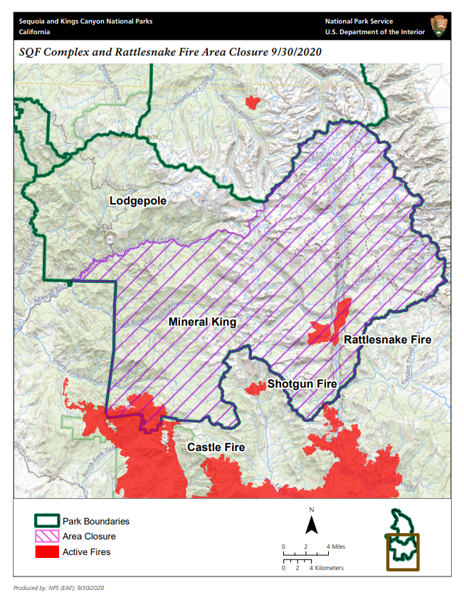
Mineral King will remain closed for the season and some wilderness closures will be in place
SEQUOIA AND KINGS CANYON NATIONAL PARKS, Calif. September 30, 2020 – Sequoia National Park will reopen on Thursday, October 1 as the evacuation warning related to the SQF Complex has been lifted for most of Three Rivers, CA. This reopening includes the Generals Highway from the Ash Mountain entrance station into Sequoia National Park to Highway 180 in Kings Canyon, and national park areas and trails along this route, including the Giant Forest. Exceptions are the Mineral King area and some wilderness lands, which will remain closed due to wildfire concerns, and facilities that are closed due to the pandemic. Sequoia National Forest also remains closed.
Sequoia National Park closed on September 15 in response to the Castle Fire on the SQF Complex. Many park staff were evacuated from the area, and for visitor and resource protection, park managers decided to close the park. The SQF Complex has now grown to over 152,000 acres.
Air quality continues to range from moderate to unhealthy for all, and visitors should take that into consideration when planning a trip. Visit our Air Quality Information web page for more information: www.nps.gov/seki/learn/nature/airqualityinfo.htm.
Potwisha and Lodgepole Campgrounds in Sequoia National Park will reopen on Saturday, October 3 by reservation only. Azalea Campground in Kings Canyon National Park will open for the winter season on Thursday, October 1 with a limited number of first come, first served sites.
Concession services including lodging, market and gift shop will open on Thursday, October 1. For details and information visit www.visitsequoia.com.
For detailed information about current conditions, air quality, and smoke impacts, please visit our Current Conditions web page: www.nps.gov/seki/planyourvisit/conditions.htm.
For updated 24-hour road and weather conditions for Sequoia and Kings Canyon National Parks, please call 559-565-3341, press 1 and press 1 again. Updated information is also available on the park’s website at www.nps.gov/seki.
Sequoia National Park to Reopen Thursday October 1
Related Incident:
Publication Type: News
Sequoia National Park to Reopen Thursday, October 1 Mineral King will remain closed for the season and some wilderness closures will be in place SEQUOIA AND KINGS CANYON NATIONAL PARKS, California September 30, 2020– Sequoia National Park will reopen on Thursday, October 1 as the evacuation warning related to the SQF Complex has been lifted for most of Three Rivers, CA. This reopening includes the Generals Highway from the Ash Mountain entrance station into Sequoia National Park to Highway 180 in Kings Canyon, and national park areas and trails along this route, including the Giant Forest. Exceptions are the Mineral King area and some wilderness lands, which will remain closed due to wildfire concerns, and facilities that are closed due to the pandemic. Sequoia National Forest also remains closed.
Sequoia National Park closed on September 15 in response to the Castle Fire on the SQF Complex. Many park staff were evacuated from the area, and for visitor and resource protection, park managers decided to close the park. The SQF Complex has now grown to over 152,000 acres.
Air quality continues to range from moderate to unhealthy for all, and visitors should take that into consideration when planning a trip. Visit our Air Quality Information web page for more information: www.nps.gov/seki/learn/nature/airqualityinfo.htm.
Potwisha and Lodgepole Campgrounds in Sequoia National Park will reopen on Saturday, October 3 by reservation only. Azalea Campground in Kings Canyon National Park will open for the winter season on Thursday, October 1 with a limited number of first come, first served sites.
Concession services including lodging, market and gift shop will open on Thursday, October 1. For details and information visit www.visitsequoia.com.
For detailed information about current conditions, air quality, and smoke impacts, please visit our Current Conditions web page: www.nps.gov/seki/planyourvisit/conditions.htm.
For updated 24-hour road and weather conditions for Sequoia and Kings Canyon National Parks, please call 559-565-3341, press 1 and press 1 again. Updated information is also available on the park’s website at www.nps.gov/seki.
SQF Complex Daily Update Oct 1
Related Incident:
Publication Type: News
Current Situation:
At 7:00 AM this morning, California Interagency Incident Management Team 2 transitioned into command of the entire SQF Complex Fire. Thank you, Incident Commander Jeff Veik, and all of CAL FIRE Team 6 for the leadership they provided on this incident.
Firefighters had another productive day on the SQF Complex yesterday. In the northwest section of the fire, there was a half-acre spot fire that was spotted in a large timber pile and worked with helicopters. Weather will be a factor in the fight today. Winds will be primarily terrain driven and vary in direction for the rest of the week. Lower relative humidity and temperatures are forecasted to be ten degrees above normal. Containment increased in the southern portion with the fire showing little activity and movement yesterday and overnight.
The primary objective continues to be full perimeter control, and under a full suppression strategy.
Today, mule trains will be traveling from Blackrock to Beach Meadows and Casa Vieja, with assistance from CONAFOR Team 3, to begin removing the structure protection wrap from the cabins in the area. Some of these cabins are over one hundred years old. We are sad to report that although wrapped and prepped, the Jiffy Pop cabin in Grey Meadows was destroyed.
Crews will continue to focus on the area between Coy Flat and the Kern River drainage, securing existing fireline. Shifting winds will have some impact on this portion of the fire. The Northwest perimeter of the fire will be patrolled, and any spot fires will be worked with aircraft. Crews will continue to work on falling many hazard trees and snags that pose a threat to containment and human safety. Areas of containment will continue to be monitored with hazards being identified and removed. This process will help repopulation efforts and lead into suppression repair, removing and identifying hazard trees and minimizing negative fire effects in the area. Large amounts of smoke from interior burning is expected, due to heavy downed fuels that continue to burn slowly inside the fire's perimeter.
The process of backhaul, breaking down and removing equipment and supplies no longer needed in the fire area, remains on the east portion of the fire and around several communities.
Evacuations:
Evacuation Orders, Map and Warnings for Tulare County.
Areas Downgraded to an Evacuation Warning:
Mineral King
Silver City
The remainder of South Fork Drive.
Residences on Blue Ridge Drive
Areas removed from Evacuation Warning List:
Three Rivers area, including but not limited to, areas of Three Rivers, South Fork Drive (below Conley Bridge), south of Heidi Drive and Cherokee Oaks
Balch Park, including Bear Creek to Rancheria Fire Road and Balch Park Road to Blue Ridge Drive
· All remaining Evacuation Orders and Evacuation Warnings remain in place
Tulare County has a structure assessment form for evacuees affected by the fire to provide contact information for County officials as the damage assessment continues.
An interactive map showing damaged structures is available.
Tulare County Health & Human Services Agency hotline for affected citizens - (559) 802-9790
The Red Cross has evacuation centers at Porterville Community College and the North Exeter Community Building. Also, call the Red Cross at 1-800-RED-CROSS or https://tinyurl.com/yafetgkj
Closures:
Sequoia and Inyo National Forests closure is extended due to fire weather severity and resource availability: Regional Order No. 20-19
Regional Emergency Fire Restrictions are in place: Regional Order No. 20-18
The Bureau of Land Management Bakersfield Office has issued a temporary emergency closure.
Road closures due to the SQF Complex may be found by clicking here.
The Temporary Flight Restriction (9/19/20) may be found here. Drones over the fire area are prohibited.
Sequoia National Park remains closed due to fire threat, including Generals Highway from Ash Mountain Entrance in Three Rivers to the Woodward Gate west
Smoke: Current air quality may be found at https://fire.airnow.gov/.
Alert: To receive emergency notifications regarding evacuations and critical events sign up at alerttc.com.
Cooperating and Assisting Organizations: Tulare County Fire Department, Tulare County Sheriff's Department, California Highway Patrol, Tule River Tribe, California Rehabilitation Center Fire Department, California Conservation Corps, California Office of Emergency Services, and Bureau of Land Management.
Safety Message: This will be a long duration event. Residents in the affected areas are encouraged to continue to prepare for the possibility of fire in their area in advance. Go to www.ready.gov/wildfires to learn how to prepare.
Southern Sierra Sequoia Smoke Outlook for Oct 1 and 2
Related Incident:
Publication Type: News
Issued at: 2020-10-01 08:35 PDT
Fire
Current fire size is 151,436 ac. containment remained at 61%. Today will see minimum humidity and increased temperatures, with very dry air. Flareups and spotting are still occurring within the perimeter and the potential to increase along the north.
Smoke
Smoke has the potential to linger with minimal transport winds expected however, communities below 1,000' elevation may see periods of improvement.
Special Notes
Higher temperatures will remain above average and continue throughout the week. Air quality alerts have been issued for areas within this outlook.
Forest Service Revises Closure Orders and Fire Restrictions in California
Related Incident:
Publication Type: Closures
VALLEJO, Calif. – The USDA Forest Service Pacific Southwest Region has revised closure orders and fire prohibitions in California. These decisions will continue to be evaluated daily.
The revisions include:
1. Easing fire restrictions – Propane and gas stove use is now permitted on developed recreation sites on National Forests in California. Developed recreation sites are defined as areas which have been improved or developed for recreation such as campgrounds and day use sites.
2. Forest Closures – Six Rivers and Klamath National Forests are no longer part of the regional closure orders but may have local restrictions. Check the websites, social media accounts, or call those respective forests for specific information on what may be opening.
Seven National Forests (NF) in California remain closed: Angeles NF, Cleveland NF, Los Padres NF, Inyo NF, San Bernardino NF, Sequoia NF, and Sierra NF. This decision will continue to be reviewed daily, taking fire and weather conditions into account.
Eleven National Forests may be open to varying degrees. Visitors should contact the following National Forests for more information on their status: Eldorado NF, Klamath NF, Lake Tahoe Basin Management Unit, Lassen NF, Mendocino NF, Modoc NF, Plumas NF, Shasta-Trinity NF, Six Rivers NF, Stanislaus NF, and Tahoe NF. For additional questions, please contact your local National Forest.
"We understand how important access to national forests is to our visitors," said Randy Moore, Regional Forester for the USDA Forest Service Pacific Southwest Region. "As we evaluate fire and weather conditions on a daily basis, we will continue to make adjustments to ensure safe
visitation. Our aim continues to prevent any new fires on the landscape."
If you do intend to visit a National Forest that is open to visitors, we continue to recommend that you not travel long distances to recreate. If you or anyone in your household is feeling sick, please remain at home and plan your trip for another time. All visitors should practice self-sufficiency during your visits to national forests. Recreating responsibly will help ensure that expanded access to recreational facilities, services, and opportunities continues. Responsible recreation practices should be maintained at all times, including:
• Maintaining at least six feet distancing from others
• Do not gather in groups and please follow the latest guidance from officials
• Communicate with others as you pass. Alert trail users of your presence and step aside to let others pass
• Pack out your trash and leave with everything you bring in and use.
• All services may not be available, so please plan accordingly.
The Forest Service manages 18 National Forests in the Pacific Southwest Region, which encompasses over 20 million acres across California, and assists State and Private forest landowners in California, Hawaii and the U.S. Affiliated Pacific Islands. National forests supply 50 percent of the water in California and form the watershed of most major aqueducts and more than 2,400 reservoirs throughout the state. For more information, visit www.fs.usda.gov/R5.
SQF Complex Actualizacin del incidente 930
Related Incident:
Publication Type: News
Situación actual:
Ayer, los bomberos tuvieron otro día productivo en la zona este del Complejo Sequoia. La contención del complejo ha aumentado a 61 %. El clima será un factor en la lucha de hoy. Los vientos estarán principalmente impulsados por el terreno y variarán en dirección durante el resto de la semana. Se pronostica que habrá humedad relativa más baja y las temperaturas estarán diez grados por encima de lo normal. La contención aumentó en los sectores norte y sur y el fuego mostró poca actividad y movimiento ayer y durante la noche. El objetivo principal sigue siendo el control total del perímetro con una estrategia de extinción total.
Hoy, las cuadrillas de bomberos continuarán enfocándose en el área entre Coy Flat y el drenaje del río Kern, mejorando la línea de control. Los vientos cambiantes tendrán algún impacto en esta parte del perímetro de la zona este. Las cuadrillas se concentrarán en asegurar las líneas existentes. Varios equipos de bomberos especializados Hot Shot y cuadrillas con intervención manual de CONAFOR de México han estado trabajando en esta área. Los equipos continuarán trabajando en la caída de muchos árboles peligrosos y obstáculos que representan una amenaza para la contención y la seguridad humana. Se continuará monitoreando las áreas de contención. Este proceso ayudará a dirigir la reparación de la extinción, identificando y eliminando árboles peligrosos y minimizando los efectos negativos del incendio en el área.
Se espera mínima actividad del fuego en los frentes norte y este del incendio. El apoyo aéreo estaba patrullando en busca de puntos críticos y extinguiéndolos a medida que ocurrían. A medida que se complete el trabajo en las áreas de mayor prioridad del incendio, las cuadrillas se desplazarán hacia arriba para abordar esta línea sin contención.
El proceso de retorno, descomposición y eliminación de equipos y suministros que ya no es necesario en el área del incendio; continúa en el sector este del incendio y alrededor de varias comunidades.
Clima: Una tendencia de calentamiento y sequía afectará el área durante los próximos días. Las temperaturas estarán diez grados por encima de lo normal y la humedad relativa caerá a alrededor de 12 %.
Evacuaciones:
- Órdenes de evacuación, mapa y advertencias para el condado de Tulare.
- Áreas que bajaron su clasificación a advertencias de evacuación:
- Mineral King
- Silver City
- El resto de South Fork Drive
- Residencia en Blue Ridge Drive
Áreas eliminadas de la lista de advertencia de evacuación:
Área de Three Rivers, lo que incluye, entre otras, las áreas de Three Rivers, South Fork Drive (por debajo de Conley Bridge), área al sur de Heidi Drive y Cherokee Oaks
Balch Park, incluido de Bear Creek a Rancheria Fire Road y de Balch Park Road a Blue Ridge Drive
Todas las órdenes y advertencias de evacuación restantes permanecen vigentes.
- El condado de Tulare cuenta con un formulario de evaluación de estructuras para que los evacuados afectados por el incendio proporcionen información de contacto a los funcionarios del condado mientras continúa la evaluación de daños.
- Un mapa interactivo que muestra las estructuras dañadas está ahora disponible.
- Línea directa de la Agencia de Salud y Servicios Humanos del condado de Tulare para ciudadanos afectados – (559) 802-9790
- La Cruz Roja tiene centros de evacuación en Porterville Community College y en North Exeter Community Building. Además, puede llamar a la Cruz Roja al 1-800-RED-CROSS, o visitar https://tinyurl.com/yafetgkj
Cierres:
- Se extendió el cierre de los Bosques Nacionales Sequoia e Inyo Orden Regional Número 20-17
- Existen restricciones regionales de emergencia contra incendios: Orden Regional Número 20-16
- La Oficina de Administración de Tierras de Bakersfield ha emitido un cierre de emergencia temporal.
- Consulte los cierres de carreteras debido al Complejo SQF haciendo clic aquí.
- Consulte la restricción temporal de vuelos (9/19/20) aquí. Los drones sobre el área del fuego están prohibidos.
- El Parque Nacional Sequoia permanece cerrado debido a la amenaza de incendio, incluida Generals Highway desde la entrada Ash Mountain en Three Rivers hasta Woodward Gate West.
Humo: La calidad actual del aire se puede encontrar en https://fire.airnow.gov/.
Alerta: Para recibir notificaciones de emergencia sobre evacuaciones y eventos críticos, regístrese en alerttc.com.
Organizaciones de colaboración y asistencia: Departamento de Bomberos del Condado de Tulare, Departamento del Sheriff del Condado de Tulare, Patrulla de Caminos de California, Tribu del Río Tule, Departamento de Bomberos del Centro de Rehabilitación de California, Cuerpo de Conservación de California, Oficina de Servicios de Emergencia de California y Oficina de Administración de Tierras.
Mensaje de seguridad: Este será un evento de larga duración. Se recomienda a los residentes en las áreas afectadas que continúen con los preparativos anticipados ante un posible incendio en su área. Visite https://www.ready.gov/wildfires para obtener información acerca de cómo prepararse.
Southern Sierra Sequoia Smoke Outlook for Sept 30 and Oct 1
Related Incident:
Publication Type: News
Issued at: 2020-09-30 08:43 PDT
Fire
Current fire size is 151,426 ac. with slight growth of 626 ac. containment increased to 61%. Today will see weather patterns with winds from the north-west. Flareups and spotting are still occurring within the perimeter with runs up to 3 miles.
Smoke
Air quality continues to improve to the east in Owens Valley and within the south of the Outlook area. Regional smoke from the north is expected to impact this outlook area with lingering smoke in the communities around the perimeter
Special Notes
Higher temperatures will remain above average and continue throughout the week. Air quality alerts have been issued for areas within this outlook.
SQF Complex Daily Update Sept 30
Related Incident:
Publication Type: News
Current Situation:
Firefighters had another productive day on the Sequoia Complex East Zone yesterday. Containment of the complex has increased to 61%. Weather will be a factor in the fight today. Winds will be primarily terrain driven and vary in direction for the rest of the week. Lower relative humidity and temperatures are forecasted to be ten degrees above normal. Containment increased in the northern and southern portions with the fire showing little activity and movement yesterday and overnight. The primary objective continues to be full perimeter control under a full suppression strategy.
Today, fire crews will continue to focus on the area between Coy Flat and the Kern River drainage, improving the control line. Shifting winds will have some impact on this portion of the East Zone perimeter. Crews will focus on securing existing lines. Several Hotshot crews and CONAFOR hand crews from Mexico have been working this area. Crews will continue to work on falling many hazard trees and snags that pose a threat to containment and human safety. Areas of containment will continue to be monitored. This process will help lead into suppression repair, removing and identifying hazard trees and minimizing negative fire effects in the area.
Minimal fire activity is expected in the northern and eastern fronts of the fire. Air support was patrolling looking for hotspots and extinguishing them as they occurred. As work is completed in higher priority areas of the fire, crews will shift up to address this uncontained line.
The process of backhaul, breaking down and removing equipment and supplies no longer needed in the fire area, proceeds on the east portion of the fire and around several communities.
Weather: A warming and drying trend will impact the area for the next several days. Temperatures will be ten degrees above normal and relative humidity will dip into the low teens.
Evacuations:
Evacuation Orders, Map and Warnings for Tulare County.
Areas Downgraded to an Evacuation Warning:
Mineral King
Silver City
The remainder of South Fork Drive.
Residences on Blue Ridge Drive
Areas removed from Evacuation Warning List:
Three Rivers area, including but not limited to, areas of Three Rivers, South Fork Drive (below Conley Bridge), south of Heidi Drive and Cherokee Oaks
Balch Park, including Bear Creek to Rancheria Fire Road and Balch Park Road to Blue Ridge Drive
· All remaining Evacuation Orders and Evacuation Warnings remain in place
Tulare County has a structure assessment form for evacuees affected by the fire to provide contact information for County officials as the damage assessment continues.
An interactive map showing damaged structures is available.
Tulare County Health & Human Services Agency hotline for affected citizens – (559) 802-9790
The Red Cross has evacuation centers at Porterville Community College and the North Exeter Community Building. Also, call the Red Cross at 1-800-RED-CROSS or https://tinyurl.com/yafetgkj
Closures:
Sequoia and Inyo National Forests closure is extended: Regional Order No. 20-17
Regional Emergency Fire Restrictions are in place: Regional Order No. 20-16
The Bureau of Land Management Bakersfield Office has issued a temporary emergency closure.
Road closures due to the SQF Complex may be found by clicking here.
The Temporary Flight Restriction (9/19/20) may be found here. Drones over the fire area are prohibited.
Sequoia National Park remains closed due to fire threat, including Generals Highway from Ash Mountain Entrance in Three Rivers to the Woodward Gate west
Smoke: Current air quality may be found at https://fire.airnow.gov/.
Alert: To receive emergency notifications regarding evacuations and critical events sign up at alerttc.com.
Cooperating and Assisting Organizations: Tulare County Fire Department, Tulare County Sheriff’s Department, California Highway Patrol, Tule River Tribe, California Rehabilitation Center Fire Department, California Conservation Corps, California Office of Emergency Services, and Bureau of Land Management.
Safety Message: This will be a long duration event. Residents in the affected areas are encouraged to continue to prepare for the possibility of fire in their area in advance. Go to https://www.ready.gov/wildfires to learn how to prepare.
Actualizacin del incidente 92920
Related Incident:
Publication Type: News
Situación actual:
Ayer, los bomberos tuvieron otro día productivo en la zona este del Complejo Sequoia. La contención del complejo ha aumentado en un 54 %. El clima cambiante será un factor en la lucha de hoy. Los vientos estarán principalmente impulsados por el terreno y variarán en dirección durante el resto de la semana. Se pronostica que la humedad relativa y las temperaturas más bajas estarán diez grados por encima de lo normal. La contención aumentó en los sectores norte y sur y el fuego mostró poca actividad y movimiento ayer y durante la noche. El objetivo principal sigue siendo el control total del perímetro. Este incendio continúa bajo una estrategia de extinción completa.
Hoy, las cuadrillas de bomberos continuarán enfocándose en mejorar los cortafuegos entre Coy Flat y el drenaje del río Kern. Los vientos cambiantes tendrán algún impacto en esta parte del perímetro de la zona este. Los combustibles pesados se siguen quemando, lo que genera más humo y menor visibilidad. Varios equipos de bomberos especializados Hot Shot y cuadrillas con intervención manual de CONAFOR de México han estado trabajando en esta área. Los equipos continuarán trabajando en la caída de muchos árboles peligrosos y obstáculos que representan una amenaza para la contención y la seguridad humana. En las áreas de contención, las cuadrillas continuarán patrullando y limpiando, asegurando la línea existente. Este proceso ayudará a dirigir la reparación de la extinción, eliminando árboles peligrosos y minimizando los efectos negativos del incendio en el área.
Se observó un movimiento mínimo en el sector norte del fuego. El apoyo aéreo estaba patrullando en busca de puntos críticos y extinguiéndolos a medida que ocurrían. Las cuadrillas se trasladaron del sector norte para ayudar a otras áreas del incendio. A medida que se complete el trabajo en las áreas de mayor prioridad del incendio, las cuadrillas se desplazarán hacia arriba para abordar esta línea sin contención.
El proceso de retorno, descomposición y eliminación de equipos y suministros que ya no se necesitan en el área del incendio, se inició en la comunidad de Camp Nelson, en el sector este del incendio y alrededor de varias comunidades.
Clima: Una tendencia de calentamiento y sequía afectará el área durante los próximos días. Las temperaturas estarán diez grados por encima de lo normal y la humedad relativa ronda los 13 o 14 °F. y, potencialmente, a un solo dígito.
Evacuaciones:
Órdenes de evacuación, mapa y advertencias para el condado de Tulare.
Las áreas bajaron su clasificación a advertencias de evacuación:
Todo South Fork Drive por debajo de Cinnamon Canyon Road
Incluido Cinnamon Canyon Road
Todas las órdenes y advertencias de evacuación restantes permanecen vigentes.
El condado de Tulare cuenta con un formulario de evaluación de estructuras para que los evacuados afectados por el incendio proporcionen información de contacto a los funcionarios del condado mientras continúa la evaluación de daños.
Un mapa interactivo que muestra las estructuras dañadas está ahora disponible.
Línea directa de la Agencia de Salud y Servicios Humanos del condado de Tulare para ciudadanos afectados –
(559) 802-9790
La Cruz Roja tiene centros de evacuación en Porterville Community College y en North Exeter Community Building. Además, puede llamar a la Cruz Roja al 1-800-RED-CROSS, o visitar https://tinyurl.com/yafetgkj
Cierres:
Se extendió el cierre de los Bosques Nacionales Sequoia e Inyo: Orden Regional Número 20-17
Existen restricciones regionales de emergencia contra incendios: Orden Regional Número 20-16
La Oficina de Administración de Tierras de Bakersfield ha emitido un cierre de emergencia temporal.
Consulte los cierres de carreteras debido al Complejo SQF haciendo clic aquí.
Consulte la restricción temporal de vuelos (9/19/20) aquí. Los drones sobre el área del fuego están prohibidos.
El Parque Nacional Sequoia permanece cerrado debido a la amenaza de incendio, incluida Generals Highway desde la entrada Ash Mountain en Three Rivers hasta Woodward Gate West.
Humo: La calidad actual del aire se puede encontrar en https://fire.airnow.gov/.
Alerta: Para recibir notificaciones de emergencia sobre evacuaciones y eventos críticos, regístrese en alerttc.com.
Organizaciones de colaboración y asistencia: Departamento de Bomberos del Condado de Tulare, Departamento del Sheriff del Condado de Tulare, Patrulla de Caminos de California, Tribu del Río Tule, Departamento de Bomberos del Centro de Rehabilitación de California, Cuerpo de Conservación de California, Oficina de Servicios de Emergencia de California y Oficina de Administración de Tierras.
Mensaje de seguridad: Este será un evento de larga duración. Se recomienda a los residentes en las áreas afectadas que continúen con los preparativos anticipados ante un posible incendio en su área. Visite https://www.ready.gov/wildfires para obtener información acerca de cómo prepararse.