
Additional Recreation Sites Open in the Sequoia National Forest
Related Incident:
Publication Type: Announcement
Forest revises Sequoia (SQF) Complex Closure Order, opening additional recreation opportunities in the Sequoia National Forest and Giant Sequoia National Monument
On October 14, 2020, the Sequoia National Forest opened additional recreational opportunities for the public originally closed due to the Sequoia (SQF) Complex fires.
Visitors may now access the Trail of 100 Giants. The roads are open from California Hot Springs to the intersection of Western Divide (M107) with Last Chance Road (Forest Road No. 22S02). From there, a visitor can travel down Last Chance Road to the Lloyd Meadow Road (Forest Road No. 22S82) then south to reach Johnsondale. Areas west to the forest boundary and north of this route are closed, while areas south are open.
The public can also travel from the intersection of Mountain Road 99 up Sherman Pass Road (Forest Road No. 22S05) to its intersection with Cherry Hill Road (Forest Road No. 22S12), where the Sherman Pass Road is closed going northeast. The forest area north of that route is closed, while the area south is open to the public.
Sherman Pass Road remains closed from its intersection with Cherry Hill Road to just south of Blackrock, where it intersects with Forest Road No. 21S02. From there, the closure boundary heads north along Forest Road No. 21S02 to tie in with the Forest boundary at Osa Meadows. All areas west of this route are closed. East of this route is open to the public.
Fire equipment continues to travel routes that are closed, extinguishing hot spots, removing hazards, and working on suppression repair. Once work is complete, additional areas will reopen to the public.
Woodcutting – With a valid woodcutting permit, firewood may be cut in the Hume Lake Ranger District and south of the Sherman Pass Road in the Kern River Ranger District. No woodcutting is allowed in the closure area.
While popular activities such as hunting, hiking, boating, and other types of general recreation are now allowed outside of the closure area, several prohibitions are still in place.
Responsible recreation practices should be maintained at all times, including:
· Maintaining at least six feet distancing from others
· Do not gather in groups and please follow the latest guidance from officials
· Communicate with others as you pass. Alert trail users of your presence and step aside to let others pass
· Pack out your trash and leave with everything you bring in and use.
· All services may not be available, so please plan accordingly.
Please call your local Ranger Station Monday – Friday from 8:00 am to 4:30 pm or email SM.FS.SequoiaNF@usda.gov for current information.
Kern River Ranger District 760-549-9533
Western Divide Ranger District 559-920-0460
Hume Lake Ranger District 559-791-5758
Supervisor’s Office 559-920-1588
Stay informed, follow our webpage at www.fs.usda.gov/sequoia, Facebook at #SequoiaNF, Twitter at @sequoiaforest or SequoiaNF OnCell app.
Tulare County Downgrading areas under Evacuation Orders
Related Incident:
Publication Type: News
County of Tulare
For Immediate Release October 13, 2020 Tulare County Downgrading areas under Evacuation Orders
VISALIA, CA –Sheriff Boudreaux has downgraded the following area from Evacuation Order to an Evacuation Warning, effective at 3:00 pm on October 13, 2020
-Cedar Slope (for residents only)
-East of the Sequoia National Forest Boundary to the Mt. Home Demonstration State Forest Boundary, and north of Hwy 190. This includes residential properties both on Balch Park Road and Bear Creek up to the Mt. Home Demonstration State Forest. (This does not include Mt. Home Demonstration State Forest or Balch Park camp ground)
A Voluntary Evacuation Warning means people living in the area are able to return to their homes, but should still be ready to evacuate should fire conditions change. Crews continue to work and travel in the area. Please do not travel into these communities as extra traffic can impact the ability for crews to quickly get in and out of the fire area. At this time, only residents are allowed to return. Please use caution when returning to these areas impacted by the SQF Complex fire.
All remaining Evacuation Orders and Evacuation Warnings remain in place.
###
SQF Complex Update for Oct 13 2020
Related Incident:
Publication Type: News
Incident Information:
Start / Report Date: 8/19/20
Cause: Lightning
Resources:
Hand Crews: 18
Dozers: 9
Size: 167,479 acres
Location: 25 miles N of Kernville, CA
Helicopters: 10
Water Tenders: 24
Containment: 70 %
Injuries: 17
Structures Destroyed: 228
Engines: 45
Total Personnel: 831
Current Situation:
A Virtual Community Meeting is being held today, October 13 at 4 p.m. This meeting will be live streamed on the Sequoia National Forest Facebook page https://www.facebook.com/SequoiaNF The video will also be available for viewing after the meeting on this page. Please send questions in advance to 2020.castle@firenet.gov.
The Mountain Home and South Fork area saw excellent progress yesterday. Squaw Creek remains a priority. Fixed and rotary wing aircraft were effective in slowing the fires spread around Homers Nose. Air operations will continue as weather (smoke) conditions allow. Ongoing operations continue to identify and mitigate potential hazards on access roads and provide structure defense as necessary on the South Fork Community. Tactical firing will continue as necessary and when safe to do so to secure South Fork Rd. to Devils Canyon.
This week warmer weather returns with light winds and decreasing humidity. Fire activity will likely increase due to the warming and drying trend. This trend will likely bring more active fire behavior especially in areas where dry fuels remain.
Structure defensive protection work progresses on Ming and Kern Cabins. Crews continue mop-up work from existing firelines and evaluating lines of engagement in the area of Sheep Mountain to Homer’s Nose. Mop-up and patrol continue on the southern portion of the fire.
A spike camp, a secondary primitive camp site for a fire crews and supported by the main camp, was set up in the Slick Rock area near Three Rivers and near Cahoon Meadow at the Hockett Ranger Station. An additional spike camp was set up near the Kern cabin. Establishing spike camps closer to the fire provides for better efficiency of time and resources.
The communities of Sequoia Crest and Cedar Slope remain a high priority and are being evaluated for repopulation. Crews and aircraft will continue to monitor these areas.
The Regional Emergency Fire Restrictions (Regional Order No. 20-21) remains in place and is extended to Oct. 15, 2020.
Tulare County Sheriff’s Office issued an evacuation order on October 6 for everything south of the intersection of the Cinnamon Canyon Road and South Fork Drive, including Cinnamon Canyon. As residents return to the opened areas, it is extremely important that they remain clear of all closure areas. Activities, such as wood gathering, and hunting are not allowed within the forest closure. For more information visit: https://www.readyforwildfire.org/post-wildfire/returning-home/. South Fork Drive needs to remain available for fire crews and heavy equipment access from Highway 198 to Cinnamon Canyon Road. Please drive with caution.
Mandatory evacuations continue for Alpine Village, Cedar Slope, Pyles Boys Camp, Redwood Drive and Sequoia Crest. Voluntary evacuation warnings for Camp Nelson, Pier Point, Ponderosa, Doyle Springs, (all residents only), Blue Ridge Drive between Balch Park Road and the Gate at Grouse Valley, Bear Creek Road from Rancheria Fire Control Road to the address of 44853 Bear Creek Road, Mineral King, Silver City, Balch Park Road from the intersection of Blue Ridge Drive to Battle Mountain Monument.
For more information visit: https://tularecounty.ca.gov/recovers/.
Tulare County has a Local Assistance Center (LAC) at the Government Plaza, 1055 West Henderson Avenue, Porterville, CA. Hours are 8:00 am to 5:00 pm, Monday through Friday, and 9:00 am to 3:00 pm Saturday and Sunday. A satellite LAC is open in Camp Nelson on Tuesdays and Thursdays, 10:00 am to 4:00 pm.
Evacuations:
- Evacuation Orders, Map and Warnings for Tulare County.
- Tulare County has a structure assessment form for evacuees affected by the fire to provide contact information for County officials as the damage assessment continues. An interactive map showing damaged structures is available.
- Tulare County Health & Human Services Agency hotline for affected citizens – (559) 802-9790
- The Red Cross has evacuation centers at Porterville Community College and the North Exeter Community Building. Also, call the Red Cross at 1-800-RED-CROSS.
Closures:
- Sequoia National Forest closure of area north of Tulare/Kern county line: Forest Order 0513-20-34 SQF Western Divide and Kern River Ranger Districts Complex Fire Area, Trail, and Road Closure
- Regional Emergency Fire Restrictions are in place: Regional Order No. 20-21 https://www.fs.usda.gov/Internet/FSE_DOCUMENTS/fseprd821778.pdf
- The Bureau of Land Management Bakersfield Office has issued a temporary emergency closure.
- Road closures due to the SQF Complex may be found by clicking here.
- The Temporary Flight Restriction (9/19/20) may be found here. Drones are prohibited.
- Sequoia and Kings Canyon National Park are open except for a large portion of the wilderness in Sequoia National Park due to wildfire. For more information please visit www.nps.gov/seki
Smoke: Current air quality may be found at https://fire.airnow.gov/
Alert: To receive emergency notifications regarding evacuations and critical events sign up at alerttc.com
Cooperating and Assisting Organizations: Southern California Edison, Tulare County Fire, Tulare County Sheriff, Tulare County OES, Tulare County Roads, California Highway Patrol, California Department of Corrections and Rehabilitation, California Conservation Corps, California Office of Emergency Services, AT&T, Verizon, California Department of Transportation, California Air National Guard, and California National Guard. CONAFOR, Mexico.
Safety Message: Prepare for the possibility of fire in advance, visit www.ready.gov/wildfires.
Virtual Community Meeting today October 13 at 4 pm
Related Incident:
Publication Type: News
SQF Complex Daily Update for Oct 12 2020
Related Incident:
Publication Type: News
Incident Information:
Start / Report Date: 8/19/20
Cause: Lightning
Resources:
Hand Crews: 18
Dozers: 11
Size: 167,388 acres
Location: 25 miles N of Kernville, CA
Helicopters: 10
Water Tenders: 20
Containment: 70 %
Injuries: 17
Structures Destroyed: 228
Engines: 47
Total Personnel: 822
Current Situation:
Air operations continued Sunday by fixed wings and helicopters. These operations will continue as smoke and weather conditions allow. Fire crews will be working west of the Kern River Drainage, in Devils Canyon, and Mineral King Road today. They will also identify and mitigate potential hazards on access roads and provide structure defense as necessary focusing on the South Fork Community. Tactical firing will continue as necessary to secure South Fork Rd. to Devils Canyon.
Monday through Thursday, warmer weather will return with light winds, and humidity decrease. Fire activity will likely increase due to the warming and drying trend.
Structure defensive protection work progresses on Mings and Kern Cabins. Crews continue mop-up work from existing firelines. Crews continue evaluating lines of engagement in the area of Sheep Mountain to Homer’s Nose. Mop-up and patrol continues on the southern portion of the fire.
Damage inspection has been completed for structures lost in the Castle Fire. The final numbers are 10 single residences damaged, and 173 destroyed 2 other minor structures damaged, and 55 destroyed.
A spike camp, a secondary primitive camp site for a fire crews and supported by the main camp, has been set up in the Slick Rock area near Three Rivers. An additional spike camp will also be set up near Cahoon Meadow at the Hockett Ranger Station. Establishing spike camps closer to the fire provides for better efficiency of time and resources.
The communities of Sequoia Crest and Cedar Slope remain a high priority and are being evaluated for repopulation. Crews and aircraft will continue to monitor these areas.
The Regional Emergency Fire Restrictions (Regional Order No. 20-21) remains in place and is extended to Oct. 15.
Giant sequoias can reach ages of up to 3,400 years. Tree ring studies of giant sequoias provide a long record of climate and fire history, helping park managers and scientists better understand relationships of climate, fire, and the giant sequoia life cycle. https:www.nps.gov/seki/learn/nature/bigtrees.htm
Tulare County Sheriff’s Office issued an evacuation order on October 6 for everything south of the intersection of the Cinnamon Canyon Road and South Fork Drive, including Cinnamon Canyon. As residents return to the opened areas, it is extremely important that they remain clear of all closure areas. Activities, such as wood gathering, and hunting are not allowed within the forest closure. For more information visit: https://www.readyforwildfire.org/post-wildfire/returning-home/. South Fork Drive needs to remain available for fire crews and heavy equipment access from Highway 198 to Cinnamon Canyon Road. Please drive with caution.
Mandatory evacuations continue for Alpine Village, Cedar Slope, Pyles Boys Camp, Redwood Drive and Sequoia Crest. Voluntary evacuation warnings for Camp Nelson, Pier Point, Ponderosa, Doyle Springs, (all residents only), Blue Ridge Drive between Balch Park Road and the Gate at Grouse Valley, Bear Creek Road from Rancheria Fire Control Road to the address of 44853 Bear Creek Road, Mineral King, Silver City, Balch Park Road from the intersection of Blue Ridge Drive to Battle Mountain Monument.
For more information visit: https://tularecounty.ca.gov/recovers/.
Tulare County has a Local Assistance Center (LAC) at the Government Plaza, 1055 West Henderson Avenue, Porterville, CA. Hours are 8:00 am to 5:00 pm, Monday through Friday, and 9:00 am to 3:00 pm Saturday and Sunday. A satellite LAC is open in Camp Nelson on Tuesdays and Thursdays, 10:00 am to 4:00 pm.
Evacuations:
- Evacuation Orders, Map and Warnings for Tulare County.
- Tulare County has a structure assessment form for evacuees affected by the fire to provide contact information for County officials as the damage assessment continues. An interactive map showing damaged structures is available.
- Tulare County Health & Human Services Agency hotline for affected citizens – (559) 802-9790
- The Red Cross has evacuation centers at Porterville Community College and the North Exeter Community Building. Also, call the Red Cross at 1-800-RED-CROSS.
Closures:
- Sequoia National Forest closure of area north of Tulare/Kern county line: Forest Order 0513-20-34 SQF Western Divide and Kern River Ranger Districts Complex Fire Area, Trail, and Road Closure
- Regional Emergency Fire Restrictions are in place: Regional Order No. 20-21 https://www.fs.usda.gov/Internet/FSE_DOCUMENTS/fseprd821778.pdf
- The Bureau of Land Management Bakersfield Office has issued a temporary emergency closure.
- Road closures due to the SQF Complex may be found by clicking here.
- The Temporary Flight Restriction (9/19/20) may be found here. Drones are prohibited.
- Sequoia and Kings Canyon National Park are open except for a large portion of the wilderness in Sequoia National Park due to wildfire. For more information please visit www.nps.gov/seki
Smoke: Current air quality may be found at https://fire.airnow.gov/
Alert: To receive emergency notifications regarding evacuations and critical events sign up at alerttc.com
Cooperating and Assisting Organizations: Southern California Edison, Tulare County Fire, Tulare County Sheriff, Tulare County OES, Tulare County Roads, California Highway Patrol, California Department of Corrections and Rehabilitation, California Conservation Corps, California Office of Emergency Services, AT&T, Verizon, California Department of Transportation, California Air National Guard, and California National Guard. CONAFOR, Mexico.
Safety Message: Prepare for the possibility of fire in advance, visit www.ready.gov/wildfires.
SQF Complex Daily Update for Oct 11 2020
Related Incident:
Publication Type: News
Incident Information:
Start / Report Date: 8/19/20
Cause: Lightning
Resources:
Hand Crews: 19
Dozers: 13
Size: 167,846 acres
Location: 25 miles N of Kernville, CA
Helicopters: 10
Water Tenders: 16
Containment: 65 %
Injuries: 17
Structures Destroyed: 228
Engines: 49
Total Personnel: 801
Current Situation:
The smoke inversion cleared over the fire, allowing for helicopter missions dropping water and retardant. Seven air tankers worked the Northern area on Saturday. Fire crews on the ground were supported by 64 hours of flight time on Saturday by helicopters and fixed-wing aircraft, dropping 135,000 gallons of retardant. Today should provide similar weather with cooling and wind, providing more opportunities for flights. An unmanned aerial system (UAS) has been ordered to assist with tactical firing.
Monday through Thursday, warmer weather will return, and humidity will increase. Air operations will be weather dependent due to smoke.
Structural defense, which includes a hose and portable pump to operate a sprinkler system, is in place for the Peck’s Cabin. Mings cabin is being assessed.
A Spike camp, a secondary primitive camp site for a fire crews and supported by the main camp, has been set up in the Slick Rock area near Three Rivers. This provides for better efficiency of time and resources.
A mobile retardant base was set up in Three Rivers, this enables aircraft to reload closer to the fireline. Residents will continue to see and hear helicopters in the area. The communities of Sequoia Crest and Cedar Slope remain a high priority and is being evaluated for potential return of the residents. Crews and aircraft will continue to monitor these areas.
The Regional Emergency Fire Restrictions (Regional Order No. 20-21) remains in place and is extended to Oct. 15.
The first giant sequoia documented sighting in the Sierras appears to have been made by a bear hunter in the spring of 1852. And although once common throughout the northern hemisphere, many people may not be aware that fossil remains of these giants have been recovered from the Jurassic Period, more than 135 million years ago!
Tulare County Officials are allowing property owners into Alpine Village, Sequoia Crest and Redwood Drive today Sunday, October 11 from 10:00 am to 2:00 pm. to provide short-term access to survey damage and assess their properties. Check in will take place at the Local Assistance Center (LAC) at 1055 W. Henderson in Porterville starting at 8:00 am. After checking in and verification of information, property owners will proceed to Camp Nelson Fire Station to be escorted into their community. Everyone will be escorted out of the area at 2 pm. Only one vehicle per property will be allowed. For more information visit: www.TulareCounty.ca.gov/
As residents return to the areas that have been opened, it is extremely important that they remain clear of all closure areas. Activities, such as wood gathering, and hunting are not allowed within the forest closure. For more information visit: https://www.readyforwildfire.org/post-wildfire/returning-home/.
Tulare County Sheriff’s Office issued an evacuation order on October 6 for everything south of the intersection of the Cinnamon Canyon Road and South Fork Drive, including Cinnamon Canyon. South Fork Drive needs to remain available for fire crews and heavy equipment access from Highway 198 to Cinnamon Canyon Road. Please drive with caution.
Camp Nelson, Pierpoint, Ponderosa, Coy Flat, Doyle Springs, Rogers Camp, and Mountain Aire are under an Evacuation Warning. Mountain Home Camp, South Fork Drive Area, Alpine Village, Cedar Slope, Pyles Boys Camp, Redwood Drive, and Sequoia Crest are under an evacuation order. For more information visit: https://tularecounty.ca.gov/recovers/.
Tulare County has a Local Assistance Center (LAC) at the Government Plaza, 1055 West Henderson Avenue, Porterville, CA. Hours are 8:00 am to 5:00 pm, Monday through Friday, and 9:00 am to 3:00 pm Saturday and Sunday. A satellite LAC is open in Camp Nelson on Tuesdays and Thursdays, 10:00 am to 4:00 pm.
Evacuations:
- Evacuation Orders, Map and Warnings for Tulare County.
- Tulare County has a structure assessment form for evacuees affected by the fire to provide contact information for County officials as the damage assessment continues. An interactive map showing damaged structures is available.
- Tulare County Health & Human Services Agency hotline for affected citizens – (559) 802-9790
- The Red Cross has evacuation centers at Porterville Community College and the North Exeter Community Building. Also, call the Red Cross at 1-800-RED-CROSS.
Closures:
- Sequoia National Forest closure of area north of Tulare/Kern county line: Forest Order 0513-20-34 SQF Western Divide and Kern River Ranger Districts Complex Fire Area, Trail, and Road Closure
- Regional Emergency Fire Restrictions are in place: Regional Order No. 20-21 https://www.fs.usda.gov/Internet/FSE_DOCUMENTS/fseprd821778.pdf
- The Bureau of Land Management Bakersfield Office has issued a temporary emergency closure.
- Road closures due to the SQF Complex may be found by clicking here.
- The Temporary Flight Restriction (9/19/20) may be found here. Drones are prohibited.
- Sequoia and Kings Canyon National Park are open except for a large portion of the wilderness in Sequoia National Park due to wildfire. For more information please visit www.nps.gov/seki
Smoke: Current air quality may be found at https://fire.airnow.gov/
Alert: To receive emergency notifications regarding evacuations and critical events sign up at alerttc.com
Cooperating and Assisting Organizations: Southern California Edison, Tulare County Fire, Tulare County Sheriff, Tulare County OES, Tulare County Roads, California Highway Patrol, California Department of Corrections and Rehabilitation, California Conservation Corps, California Office of Emergency Services, AT&T, Verizon, California Department of Transportation, California Air National Guard, and California National Guard. CONAFOR, Mexico.
Safety Message: Prepare for the possibility of fire in advance, visit www.ready.gov/wildfires.
Tulare County Downgrading areas under Evacuation Orders
Related Incident:
Publication Type: News
County of Tulare
For Immediate Release
October 10, 2020
Tulare County Downgrading areas under Evacuation Orders
VISALIA, CA –Sheriff Boudreaux has downgraded the following area from Evacuation Order to a Voluntary Evacuation Warning:
Nelson Drive, from the intersection of Nelson Drive and Skyline to the end of Nelson Drive.
A Voluntary Evacuation Warning means people living in the area are able to return to their homes, but should still be ready to evacuate should fire conditions change.
All remaining Evacuation Orders and Voluntary Evacuation Warnings remain in place. Crews continue to work and travel in the area. Please do not travel into these communities as extra traffic can impact the ability for crews to quickly get in and out of the fire area.
At this time, only residents are allowed to return.
All remaining Evacuation Orders and Evacuation Warnings remain in place.
SQF Complex Daily Update for Oct 10
Related Incident:
Publication Type: News
Incident Information:
Start / Report Date: 8/19/20
Cause: Lightning
Resources:
Hand Crews: 19
Dozers: 13
Size: 166,318 acres
Location: 25 miles N of Kernville, CA
Helicopters: 10
Water Tenders: 15
Containment: 65 %
Injuries: 17
Structures Destroyed: 228
Engines: 50
Total Personnel: 741
Current Situation:
Smoke inversion was heavy on Friday limiting visibility and flights. As visibility allows, aircraft use will increase, focusing on dropping water and retardant in the areas most at risk. The next few days will remain cool and with some wind today. Reduced fire behavior is expected today. The fireline in and around South Fork is being reinforced. Air operations are weather dependent due to smoke.
The Hockett Meadow Ranger Station has been wrapped. Structural protection for the Kern Cabin was completed on Friday. Peck’s Cabin should be completed today.
A mobile retardant base (MRB) has been set up in Three Rivers. As a result, residents can expect to see and hear helicopters in the area. A high priority continues for crews to prepare the communities of Sequoia Crest and Cedar Slope for people to return. Crews and aircraft will continue to monitor these areas.
Because of their long lives, giant sequoias have an exceptionally long chronology of past fires recorded in their rings.
The communities of Cedar Slope, Alpine Village, Sequoia Crest, and Redwood Drive Tulare County Officials are allowing for short term visits by owners, enabling them to survey damage and salvage items. Cedar Slope residents will have access today, Saturday, October 10 from 10:00 am to 2:00 pm. Alpine Village, Sequoia Crest and Redwood Drive have access tomorrow, Sunday, October 11 from 10:00 am to 2:00 pm. Check in will take place at the Local Assistance Center (LAC) at 1055 W. Henderson in Porterville starting at 8:00 am. After checking in and verification of information, property owners will proceed to Camp Nelson Fire Station to be escorted into their community. Everyone will be escorted out of the area at 2 pm. Only property owners on the designated day will be granted temporary access to their properties, in their respective community. Only one vehicle per property will be allowed. For more information visit: www.TulareCounty.ca.gov/
As residents return to the areas that have been opened, it is extremely important that they remain clear of all closure areas. Activities, such as wood gathering and hunting are not allowed within the forest closure. For more information visit: https://www.readyforwildfire.org/post-wildfire/returning-home/.
Tulare County Sheriff’s Office issued an evacuation order on October 6 for everything south of the intersection of the Cinnamon Canyon Road and South Fork Drive, including Cinnamon Canyon. South Fork Drive needs to remain available for fire crews and heavy equipment access from Highway 198 to Cinnamon Canyon Road. Please drive with caution.
Camp Nelson, Pierpoint, Ponderosa, Coy Flat, Doyle Springs, Rogers Camp, and Mountain Aire are under an Evacuation Warning. Mountain Home Camp, South Fork Drive Area, Alpine Village, Cedar Slope, Pyles Boys Camp, Redwood Drive, and Sequoia Crest are under an evacuation order. For more information visit: https://tularecounty.ca.gov/recovers/.
Tulare County has a Local Assistance Center (LAC) at the Government Plaza (1055 West Henderson Avenue, Porterville, CA). Hours are 8:00 am to 5:00 pm, Monday through Friday, and 9:00 am to 3:00 pm Saturday and Sunday. A satellite LAC is open in Camp Nelson on Tuesdays and Thursdays, 10:00 am to 4:00 pm.
Evacuations:
- Evacuation Orders, Map and Warnings for Tulare County.
- Tulare County has a structure assessment form for evacuees affected by the fire to provide contact information for County officials as the damage assessment continues. An interactive map showing damaged structures is available.
- Tulare County Health & Human Services Agency hotline for affected citizens – (559) 802-9790
- The Red Cross has evacuation centers at Porterville Community College and the North Exeter Community Building. Also, call the Red Cross at 1-800-RED-CROSS.
Closures:
- Sequoia National Forest closure of area north of Tulare/Kern county line: Forest Order 0513-20-34 SQF Western Divide and Kern River Ranger Districts Complex Fire Area, Trail, and Road Closure
- Regional Emergency Fire Restrictions are in place: Regional Order No. 20-18
- The Bureau of Land Management Bakersfield Office has issued a temporary emergency closure.
- Road closures due to the SQF Complex may be found by clicking here.
- The Temporary Flight Restriction (9/19/20) may be found here. Drones are prohibited.
- Sequoia and Kings Canyon National Park are open except for a large portion of the wilderness in Sequoia National Park due to wildfire. For more information please visit www.nps.gov/seki
Smoke: Current air quality may be found at https://fire.airnow.gov/
Alert: To receive emergency notifications regarding evacuations and critical events sign up at alerttc.com
Cooperating and Assisting Organizations: Southern California Edison, Tulare County Fire, Tulare County Sheriff, Tulare County OES, Tulare County Roads, California Highway Patrol, California Department of Corrections and Rehabilitation, California Conservation Corps, California Office of Emergency Services, AT&T, Verizon, California Department of Transportation, California Air National Guard, and California National Guard. CONAFOR, Mexico.
Safety Message: Prepare for the possibility of fire in advance, visit www.ready.gov/wildfires.
SQF Complex Daily Update for Oct 9 2020
Related Incident:
Publication Type: News
Incident Information:
Start / Report Date: 8/19/20
Cause: Lightning
Resources:
Hand Crews: 20
Dozers: 12
Size: 164,993 acres
Location: 25 miles N of Kernville, CA
Helicopters: 10
Water Tenders: 16
Containment: 65 %
Injuries: 17
Structures Destroyed: 228
Engines: 6
Total Personnel: 841
Current Situation:
Firing operations in the Northwest corner of South Fork to Devils Canyon are ongoing. Structure protection was completed yesterday at the Hockett Meadow Ranger Station. It was wrapped with a heat reflective material that helps protect the structure from fire. Peck’s Cabin and Buffalo Cabin will be wrapped today, weather conditions (smoke) permitting.
Hockett Meadow Ranger Station was built in 1934 by the Civilian Conservation Corps. This National Park Service rustic building is in Mineral King, a subalpine glacial valley located in the southern part of Sequoia National Park. The valley lies at the headwaters of the East Fork of the Kaweah River. The Mineral King Road is a long and winding road built in 1873. The Mineral King Valley was added to Sequoia National Park in 1978 and is popular among backpackers and hikers.
Temperatures will be similar to yesterday, with a cooling trend and increased humidity. As the smoke lifts aircraft use will increase, focusing on dropping water and retardant in the areas most at risk.
A high priority for crews is to prepare the communities of Sequoia Crest and Cedar Slope for people to return. There are sections that are unburnt and may burn causing an increase of visible smoke from inside the perimeter. Crews and aircraft will continue to monitor these areas. A mobile retardant base (MRB) is being set up in Three Rivers, residents can expect to see and hear helicopters in the area.
Tulare County Sheriff’s Office issued an evacuation order on October 6 for everything south of the intersection of the Cinnamon Canyon Road and South Fork Drive, including Cinnamon Canyon. South Fork Drive needs to remain available for fire crews and heavy equipment access from Highway 198 to Cinnamon Canyon Road. Please drive with caution.
Camp Nelson, Pierpoint, Ponderosa, Coy Flat, Doyle Springs, Rogers Camp, and Mountain Aire are under an Evacuation Warning. Mountain Home Camp, South Fork Drive Area, Alpine Village, Cedar Slope, Pyles Boys Camp, Redwood Drive, and Sequoia Crest are under an evacuation order. For more information visit: https://tularecounty.ca.gov/recovers/.
Tulare County has a Local Assistance Center (LAC) at the Government Plaza (1055 West Henderson Avenue, Porterville, CA). Hours are 8:00 am to 5:00 pm, Monday through Friday, and 9:00 am to 3:00 pm Saturday and Sunday. A satellite LAC is open in Camp Nelson on Tuesdays and Thursdays, 10:00 am to 4:00 pm.
The communities of Cedar Slope, Alpine Village, Sequoia Crest, and Redwood Drive Tulare County Officials will allow for short term visits by owners, enabling them to survey damage and salvage items. Cedar Slope residents will have access on Saturday, October 10 from 10:00 am to 2:00 pm. Alpine Village, Sequoia Crest and Redwood Drive have access Sunday, October 11 from 10:00 am to 2:00 pm. Check in will take place at the Local Assistance Center (LAC) at 1055 W. Henderson in Porterville starting at 8:00 am. After checking in and verification of information, property owners will proceed to Camp Nelson Fire Station to be escorted into their community. Everyone will be escorted out of the area at 2 pm. Only property owners and on the designated day will be granted temporary access to their properties, in their respective community. Only one vehicle per property will be allowed. For more information visit: www.TulareCounty.ca.gov/
As residents return to the areas that have been opened, it is extremely important that they remain clear of all closure areas. Activities, such as wood gathering and hunting are not allowed within the forest closure. For more information visit: https://www.readyforwildfire.org/post-wildfire/returning-home/.
Evacuations:
- Evacuation Orders, Map and Warnings for Tulare County.
- Tulare County has a structure assessment form for evacuees affected by the fire to provide contact information for County officials as the damage assessment continues. An interactive map showing damaged structures is available.
- Tulare County Health & Human Services Agency hotline for affected citizens – (559) 802-9790
- The Red Cross has evacuation centers at Porterville Community College and the North Exeter Community Building. Also, call the Red Cross at 1-800-RED-CROSS.
Closures:
- Sequoia National Forest closure of area north of Tulare/Kern county line: Forest Order 0513-20-34 SQF Western Divide and Kern River Ranger Districts Complex Fire Area, Trail, and Road Closure
- Regional Emergency Fire Restrictions are in place: Regional Order No. 20-18
- The Bureau of Land Management Bakersfield Office has issued a temporary emergency closure.
- Road closures due to the SQF Complex may be found by clicking here.
- The Temporary Flight Restriction (9/19/20) may be found here. Drones are prohibited.
- Sequoia and Kings Canyon National Park are open except for a large portion of the wilderness in Sequoia National Park due to wildfire. For more information please visit www.nps.gov/seki
Smoke: Current air quality may be found at https://fire.airnow.gov/
Alert: To receive emergency notifications regarding evacuations and critical events sign up at alerttc.com
Cooperating and Assisting Organizations: Southern California Edison, Tulare County Fire, Tulare County Sheriff, Tulare County OES, Tulare County Roads, California Highway Patrol, California Department of Corrections and Rehabilitation, California Conservation Corps, California Office of Emergency Services, AT&T, Verizon, California Department of Transportation, California Air National Guard, and California National Guard. CONAFOR, Mexico.
Safety Message: Prepare for the possibility of fire in in advance, visit www.ready.gov/wildfires.
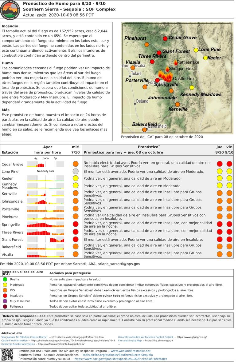
SQF Complex Daily Update for Oct 8
Related Incident:
Publication Type: News
Incident Information:
Start / Report Date: 8/19/20
Cause: Lightning
Resources:
Hand Crews: 18
Dozers: 21
Size: 162,952 acres
Location: 25 miles N of Kernville, CA
Helicopters: 8
Water Tenders: 11
Containment: 65 %
Injuries: 17
Structures Destroyed: 228
Engines: 51
Total Personnel: 749
Current Situation:
The uncontained fire’s edge to the north continues to burn actively. Heavy vegetation, snags, and steep terrain make it difficult to access the fires edge. Threats to infrastructure on Case Mountain, the Hockett Ranger Station, Peck’s Cabin, Buffalo Cabin, several sequoia groves and wilderness values within Sequoia National Park continue. Hockett Meadow ranger station and other structures in South Fork are being prepped for fire protection wrap. Crews are working to stop the fire from spreading and will focus on securing the perimeter and building contingency line along Mineral King Road to Case Mountain.
As the temperatures start to cool and the smoke begins to clear, fire activity is expected to increase. The potential for smoke columns starting to form near Homers Nose may be seen in the South Fork and Three Rivers areas. With clear visibility, there will be an increased use of aircraft and helicopters to focus on dropping water and fire retardant in the areas most at risk.
Tulare County Sheriff’s Office has issued an evacuation order on October 6 for everything south of the intersection of the Cinnamon Canyon Road and South Fork Drive, including Cinnamon Canyon. South Fork Drive needs to remain available for fire crews and heavy equipment access from Highway 198 to Cinnamon Canyon Road. Please drive with caution.
Camp Nelson, Pierpoint, Ponderosa, Coy Flat, Doyle Springs, Rogers Camp, and Mountain Aire are under an Evacuation Warning. Mountain Home Camp, South Fork Drive Area, Alpine Village, Cedar Slope, Pyles Boys Camp, Redwood Drive, and Sequoia Crest are under an evacuation order. For more information visit: https://tularecounty.ca.gov/recovers/.
The southern perimeter is holding. Crews will focus on removing fire weakened trees and hot spots in this area. Preparing the communities of Sequoia Crest and Cedar Slope for people to return to these areas remains a high for fire crews. There are sections that are unburnt and may burn causing an increase of visible smoke from inside the perimeter. Crews and aircraft will continue to monitor these areas.
Tulare County has opened a Local Assistance Center (LAC) at the Government Plaza (1055 West Henderson Avenue, Porterville, CA). Hours are 8:00 am to 5:00 pm, Monday through Friday, and 9:00 am to 3:00 pm on Saturday and Sunday. A satellite LAC is open in Camp Nelson on Tuesdays and Thursdays, 10:00 am 4:00 pm.
For the communities of Cedar Slope, Alpine Village, Sequoia Crest, and Redwood Drive Tulare County Officials will allow for short term visits by owners, enabling them to survey damage and salvage items. Cedar Slope residents will have access on Saturday, October 10 from 10:00 am to 2:00 pm. Alpine Village, Sequoia Crest and Redwood Drive will have access Sunday, October 11 from 10:00 am to 2:00 pm. Check in will take place at the Local Assistance Center (LAC) at 1055 W. Henderson in Porterville starting at 8:00 am. After checking in and verification of information, property owners can then proceed to Camp Nelson Fire Station where they will be escorted into their community. Everyone will be escorted out of the area at 2 pm. Only property owners on the designated day will be granted temporary access to their properties, in their respective community. Only one vehicle per property will be allowed. For more information visit: www.TulareCounty.ca.gov/
As residents return to the areas that have been opened, it is extremely important that they continue remain clear of all closure areas. Activities, such as wood gathering and hunting are not allowed within the forest closure. For more information visit: https://www.readyforwildfire.org/post-wildfire/returning-home/.
We appreciate the outpouring of gratitude from the public and community organizations for our firefighters, including CONAFOR Fire Crews from Mexico and the United States. For those who would like the opportunity to thank our firefighters, you can tag us on Facebook at @sequoiaforest or send cards to: Sequoia National Forest Headquarters, ATTN: SQF Complex Firefighters, 1839 South Newcomb Street Porterville, CA 93257. Please note we are only accepting cards and thank you for your support.
Evacuations:
- Evacuation Orders, Map and Warnings for Tulare County.
- Tulare County has a structure assessment form for evacuees affected by the fire to provide contact information for County officials as the damage assessment continues. An interactive map showing damaged structures is available.
- Tulare County Health & Human Services Agency hotline for affected citizens – (559) 802-9790
- The Red Cross has evacuation centers at Porterville Community College and the North Exeter Community Building. Also, call the Red Cross at 1-800-RED-CROSS.
Closures:
- Sequoia National Forest closure of area north of Tulare/Kern county line: Forest Order 0513-20-34 SQF Western Divide and Kern River Ranger Districts Complex Fire Area, Trail, and Road Closure
- Regional Emergency Fire Restrictions are in place: Regional Order No. 20-18
- The Bureau of Land Management Bakersfield Office has issued a temporary emergency closure.
- Road closures due to the SQF Complex may be found by clicking here.
- The Temporary Flight Restriction (9/19/20) may be found here. Drones are prohibited.
- Sequoia and Kings Canyon National Park are open except for a large portion of the wilderness in Sequoia National Park due to wildfire. For more information please visit www.nps.gov/seki
Smoke: Current air quality may be found at https://fire.airnow.gov/
Alert: To receive emergency notifications regarding evacuations and critical events sign up at alerttc.com
Cooperating and Assisting Organizations: Southern California Edison, Tulare County Fire, Tulare County Sheriff, Tulare County OES, Tulare County Roads, California Highway Patrol, California Department of Corrections and Rehabilitation, California Conservation Corps, California Office of Emergency Services, AT&T, Verizon, California Department of Transportation, California Air National Guard, and California National Guard. CONAFOR, Mexico.
Safety Message: Prepare for the possibility of fire in their area in advance, visit www.ready.gov/wildfires.