
Superstition and Hidden Fires Update August 30 2020
Related Incident:
Publication Type: News
Superstition Fire
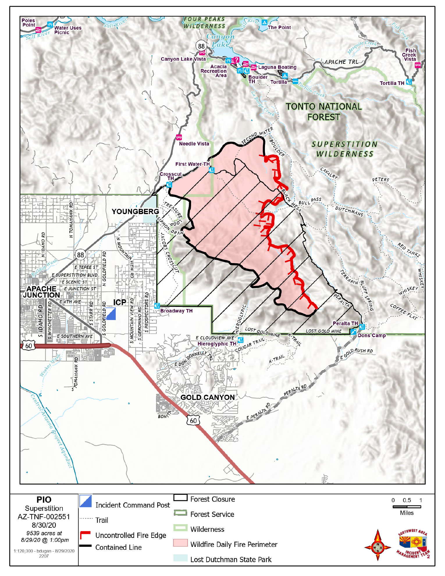
Acres: 9539
Percent Containment: 58%
Start Date: August 20, 2020
Injuries: 0
Cause: Lightning
Origin Location: Superstition Mountains, Tonto NF
Hidden Fire
Acres: 4307
Percent Containment: 0%
Start Date: August 25, 2020
FireInjuries: 0
Origin Location: Sierra Poancha Mountains, Skunk Drainage
Cause: Lightning
Thunderstorms Douse Superstition Fire and Bring Moisture to Hidden Fire: Flash Flood Warnings
SUPERSTITION FIRE:
The HWY 88 corridor will be reopening at 0600 hour today, August 30, 2020 from Lost Dutchman State Park up to Fish Creek where the road was closed at the washout.
YESTERDAY: The Superstition Fire showed minimal growth yesterday and received heavy rain last night. Primary fire activity was in the northeast, within Superstition Wilderness.
TODAY’S ACTIVITY: Minimal fire behavior is expected on the Superstition Fire today. Fire crews will continue to patrol and monitor the fire perimeter. The Southwest Area Incident Management Team 2 will return the fire to the local unit today, Sunday, at 7:00 PM.
ROAD CLOSURES & RECREATION USE OF THE FOREST: This includes the closure of the following areas
AIR SUPPORT: Due to the increased fire activity through-out the Southwest and California air support remains limited. We are using shared air resources of air tankers and helicopters with our neighboring Type 1 Incident Management Team.
HIDDEN FIRE:
Southwest Area Incident Management Team 2 led by Incident Commander John Pierson assumed command of the Hidden Fire on Saturday morning, August 29, 2020 at 0600.
YESTERDAY: Hidden fire was active producing drifting smoke that settled in the Roosevelt Lake Valley overnight. The smoke should begin to clear and lift by mid-morning today. The fire showed moderate behavior on the northwest side within Skunk Tank Canyon as well as backing downslope towards Rock House Springs. Fire activity on the eastern fire perimeter was burning along Road 416 within the 2018 Bear Fire scar in open pine and grasses. A southerly fire growth through pine and pinyon/juniper showed moderate activity with occasional single tree torching and short-range spotting.
TODAY: Fire crews will conduct firing operations on the southern portion of the fire perimeter. Structure protection preparation on the northeast side of the fire perimeter will continue. The fire will continue to grow north, east and west. Fire line construction and fire line improvement will continue within the Tonto Basin.
AIR SUPPORT: Due to the increased fire activity through-out the Southwest and California air support remains limited. We are using shared air resources of air tankers and helicopters with our neighboring Type 1 Incident Management Team.
Gila County Sheriff’s Office placed residents in the communities of Brownsville and Jacks Corner in “SET” Status on 8/28/2020.
Wildfires are a No Drone Zone. The temporary flight restriction in place over the fire area please visit: https://tfr.faa.gov/save_pages/detail_0_8593.html for additional information. As a reminder, every time a drone is seen near the fire all aircraft are grounded until we can be sure the drone is clear of the area. For more information visit Know Before You Fly, http://knowbeforeyoufly.org.
Fire Information Phone Line: 520-261-5021
Fire Media Phone Line: 520-369-3757
InciWeb: https://inciweb.nwcg.gov/incident/7046/
Facebook: https://www.facebook.com/Superstition-Fire-Info-102207198283449
Smoke Outlook: wildlandfiresmoke.net/outlooks/EasternArizona
Hwy 88 Corridor reopens at 6 am Sunday August 30
Related Incident:
Publication Type: News
The Hwy 88 Corridor reopens at 6 a.m. Sunday August 30, 2020. It will be open from Lost Dutchman State Park as far as Fish Creek where the existing washout closure still remains in effect.
Superstition Fire Morning Update August 29 2020
Related Incident:
Publication Type: News
Acres: 9643
Percent Containment: 34%
Start Date: August 20, 2020
Injuries: 0
Cause: Lightning
Origin Location: Superstition Mountains, Tonto NF
Crews Bring Containment to 34% on the Superstition Fire
YESTERDAY: Islands of unburned fuels in the interior of the Superstition Fire atop Black Mesa began showing activity by noon yesterday. Due to increased humidity the night before, fire growth was not significant. In midafternoon, a flank of fire north of Yellow Peak began backing downslope into West Boulder Canyon. Minimal winds and the increase in humidity allowed crews to secure containment lines to 34% along the NW fire perimeter. Arizona DOT focused on mowing the right-of-way between Tortilla Flat and Canyon Lake in order to improve the highway corridor as a potential control line, if needed.
TODAY’S ACTVITY: Fire behavior on the Superstition Fire will continue to be affected by possible afternoon thunderstorm buildup and outflow winds driving fire spread. Crews will remain focused on keeping the fire south of the HWY 88 corridor and continue to protect the infrastructure and values at risk in area communities. The Southwest Area Team 2 led by Incident Commander John Pierson also assumed command of the Hidden Fire today.
Be alert to the possibility of flooding with thunderstorm activity this weekend. Please be extra careful driving with the increase of firefighter presence on roads around Apache Junction.
REMINDER: This is a full suppression fire. Strategic objectives protect the identified values at risk, including surrounding communities, critical infrastructure, state and federal lands. Air quality impacts are being minimized by keeping fire within the Superstition Wilderness. Firefighter and public safety are the highest priority while engaging the fire.
AIR SUPPORT: Due to the increased fire activity through-out the Southwest and California air support remains limited. We are using shared air resources of air tankers and helicopters with our neighboring Type 1 Incident Management Team.
ROAD CLOSURES & RECREATION USE OF THE FOREST: This includes the closure of the following areas
AZ HWY 88
Areas west of Peralta Canyon Road, areas north of Peralta Canyon Road, and the Peralta Trail.
Canyon Lake Recreational areas – please visit Tonto NF website for closure information: https://www.fs.usda.gov/detail/tonto/home/?cid=FSEPRD759501
View the closure order and map at: https://inciweb.nwcg.gov/incident/closures/7046/
Wildfires are a No Drone Zone. The temporary flight restriction in place over the fire area please visit: https://tfr.faa.gov/save_pages/detail_0_8593.html for additional information. As a reminder, every time a drone is seen near the fire all aircraft are grounded until we can be sure the drone is clear of the area. For more information visit Know Before You Fly, http://knowbeforeyoufly.org.
Fire Information Phone Line: 520-261-5021
InciWeb: https://inciweb.nwcg.gov/incident/7046/
Facebook: https://www.facebook.com/Superstition-Fire-Info-102207198283449
Smoke Outlook: wildlandfiresmoke.net/outlooks/EasternArizona
Wildfire Smoke and COVID-19: https://www.cdc.gov/coronavirus/2019-ncov/php/smoke-faq.html
Superstition Fire Update August 28 2020
Related Incident:
Publication Type: News
Superstition Fire – August 28, 2020 Update
Percent Containment: 7%
Start Date: August 20, 2020
CHALLENGES OF SMOKE IMPACTS TO FIREFIGHTERS AND COMMUNITY
Superstition Fire Update Thursday August 27 2020
Related Incident:
Publication Type: News
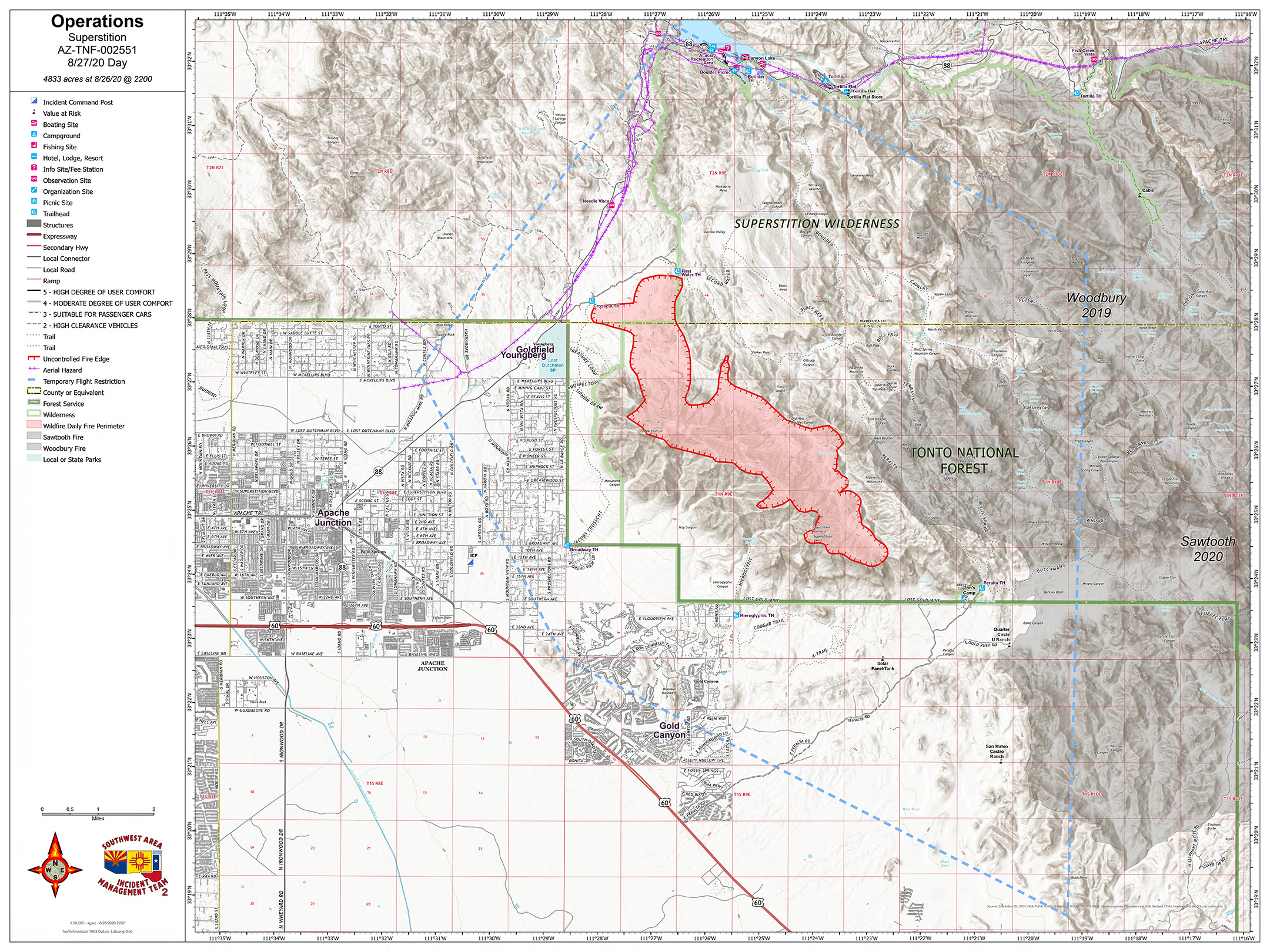
Superstition Fire – August 27, 2020 Morning Update
Southwest Area Type 1 Team 2 Incident Commander John Pierson Has Taken Command of the Superstition Fire
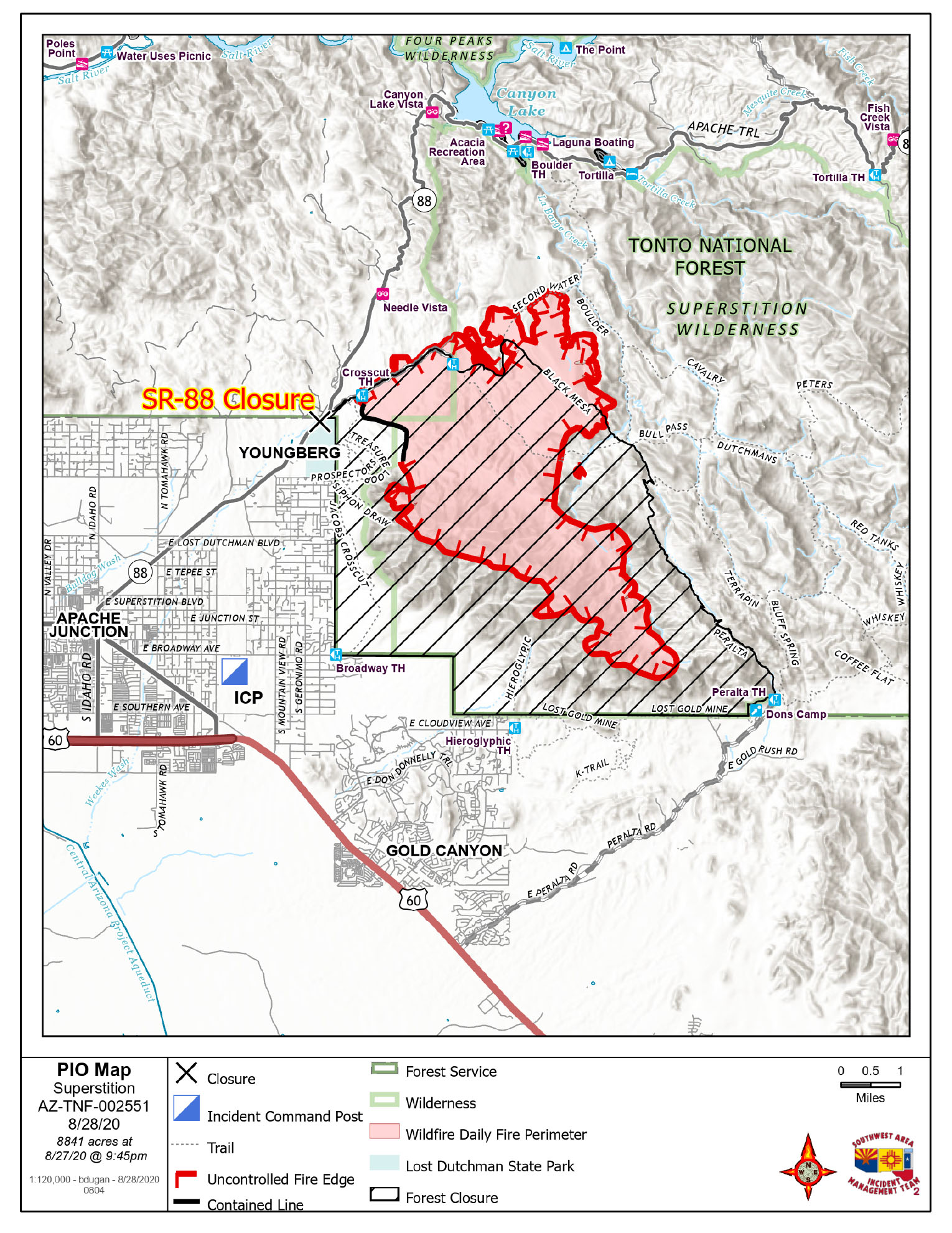
Acres: 4,833
Percent Containment: 0%
Start Date: August 20, 2020
Cause: Lightning
Origin Location: Superstition Mountains, Tonto NF
Injuries: 0
Crews are on scene and additional resources are on order
TODAY: As of 0600 hours today the Southwest Area Type 1 Incident Management Team 2 – Incident Commander John Pierson, assumed the management of the Superstition Fire. The transfer of command from the Tonto National Forest to a Type 1 team will enable ordering of additional support of resources to the incident. Fire crews and support staff will continue to arrive today. “With the extreme temperatures, firefighter safety will be our focus as we develop our strategies to address the fire.” John Pierson-IC.
Today's Activity: The community can expect to see an increased firefighter presence on and around Apache Junction as crews arrive. Firefighters will be given assignments based upon the plan of attack by fire managers. This is a full suppression fire. The strategy for suppression includes constructing fire lines and identifying holding features where safety risks are minimized and there is a greater chance of success in containing the fire on the mountain. In the communities of Apache Junction, Gold Canyon and surrounding areas crews will assess potential threats to homes and infrastructure, identify access routes and develop contingency plans in the event of fire spreading into the area.
Air attack will include both rotary and fixed wing aircraft that are being utilized in the region. Air tankers are just one tool we utilize in the suppression of a fire. The use of retardant in certain areas allows the firefighters to get into the area and continue the hard work of creating fireline to stop the incoming head of the fire spread. With temperatures exceeding 100° and higher this is a continuing challenge for the crews on the ground. Crews will continue to closely monitor the fire’s edge along the southern edge and around to the northern edge to ensure that the communities in the areas of Apache Junction, Gold Canyon, and HWY 88 corridor are minimized.
ROAD CLOSURES & RECREATION USE OF THE FOREST
This includes the closure of the following areas
AZ HWY 88
Areas west of Peralta Canyon Road, areas north of Peralta Canyon Road, and the Peralta Trail.
Canyon Lake Recreational areas – please visit Tonto NF website for closure information: https://www.fs.usda.gov/detail/tonto/home/?cid=FSEPRD759501
View the closure order and map at: https://inciweb.nwcg.gov/incident/closures/7046/
Wildfires are a No Drone Zone. The temporary flight restriction in place over the fire area please visit: https://tfr.faa.gov/save_pages/detail_0_8593.html for additional information. As a reminder, every time a drone is seen near the fire all aircraft are grounded until we can be sure the drone is clear of the area. For more information visit Know Before You Fly, http://knowbeforeyoufly.org.
Fire Information Email: superstitionfire2020@gmail.com
InciWeb: https://inciweb.nwcg.gov/incident/7046/
Facebook: https://www.facebook.com/Superstition-Fire-Info-102207198283449
Smoke Outlook: wildlandfiresmoke.net/outlooks/EasternArizona
Superstition Public Safety Closure
Related Incident:
Publication Type: Closures
UNITED STATES DEPARTMENT OF AGRICULTUREFOREST SERVICE TONTO NATIONAL FOREST MESA RANGER DISTRICTSuperstition Fire Public Safety Closure Order
PROHIBITIONS
Pursuant to 16 U.S.C. § 551 and 36 C.F.R. § 261.50(a), the following acts are prohibited within the area described in this Order (the “Restricted Area”) and as depicted on the attached map, hereby incorporated into this Order as Exhibit A, all within the Tonto National Forest, Pinal County, Arizona.1. Going into or being upon the Restricted Area.36 C.F.R.§261.52(e).
EXEMPTIONS
Pursuant to 36 CFR § 261.50 (e), the following persons are exempt from this order:1. Persons with a written Forest Service authorization specifically exempting them from the effect of this Order.
2. Any Federal, State, or local officer, or member of any organized rescue or firefighting resource in the performance of an official duty.
RESTRICTED AREA
All National Forest System lands contained within the following area.Beginning at NFSR 78/SR 88 Junction, following NFSR 78 northeast to the First Water Trailhead, then following NFST 104 southeast approximately .25 miles to NFST 236, then following NFST 236 northeast to NFST 241, then following NFST 241 southeast to NFST 104, then following NFST southeast to NFST 104, then following NFST 104 southeast to NFST 102, then following NFST 102 southeast to Peralta Trailhead, then proceeding southwest from Peralta Trailhead to the Forest boundary, then following the Forest boundary west then north forapproximately 12 miles to NFSR 78.
Order Number: 03-12-03-20-400
PURPOSE
The purpose of this Order is to close the Restricted Area during firefighting and emergency operations for the protection of public health and safety.
IMPLEMENTATION
1. This Order will be in effect at_0600 . on August 25, 2020 and shall remain in effect until September 30, 2020 or until rescinded, whichever occurs first.
2. A map identifying the Restricted Area is attached and made part of this Order as Exhibit A.
3. Any violation of this prohibition is punishable as a Class B misdemeanor by a fine of not more than $5,000 for individuals or $10,000 for organizations, or by imprisonment for not more than six (6) months, or both (see16 U.S.C.551, 18 U.S.C.3571(b)(6), 18 U.S.C.3581(b)(7)).
4. Further information regarding this Order may be obtained at the Tonto National Forest Supervisor’s Office in Phoenix, Arizona, (602)225-5200, or at Mesa Ranger District Office, (480)610-3300.
Dated this 26th day of August_ 2020, at Phoenix, Arizona
NEIL BOSWORTH
Forest Supervisor
Superstition Fire Grows to 4430 Acres Management Team Assigned
Related Incident:
Publication Type: News
TONTO NATIONAL FOREST – August 26th 2020
Location: Superstition Wilderness Date Reported: 8/20/2020
Size: 4,430 Containment: 0%
Stage 1 Fire Restrictions are currently in effect on the Tonto National Forest. Visit our website for more information at https://www.fs.usda.gov/tonto
Public Safety Closure in Effect 8262020
Related Incident:
Publication Type: Closures
There will be a Public Safety Closure in effect starting tomorrow. The closure will include areas west of Peralta Canyon Road, areas north of Peralta Canyon Road, and the Peralta Trail. A copy of the order will be posted prior to implementation. Please continue to check the Tonto National Forest Facebook page for updates throughout the day.
Superstition Fire Grows to 2664 acres
Related Incident:
Publication Type: News
TONTO NATIONAL FOREST – August 25th 2020
Location: Superstition Wilderness Date Reported: 8/20/2020
Size: 2,664 Containment: 0%
Smoke and Flames will be visible from the East Valley and Gold Canyon areas. There is 1 engine assigned to the Peralta Canyon Rd area, and 1 engine assigned to the First Water area monitoring fire behavior throughout the day.
There will be a Public Safety Closure in effect starting tomorrow. The closure will include areas west of Peralta Canyon Road, areas north of Peralta Canyon Road, and the Peralta Trail. A copy of the order will be posted prior to implementation. Please continue to check the Tonto National Forest Facebook page for updates throughout the day.
For information on National Preparedness Levels, visit the National Interagency Fire Center web site at: https://www.nifc.gov/fireInfo/fireinfo_prepLevels.html
Tonto National Forest Superstition Fire Update 82220
Related Incident:
Publication Type: News
TONTO NATIONAL FOREST – August 22nd 2020
Location: North of Gold Canyon, AZ Date Detected: 8/20/2020
Size: 1,218 acres Containment: 0%
Cause: Lightning Resources: 1 Engine, 1 recon aircraft