
Air quality update Friday Sept 18
Related Incident:
Publication Type: Announcement
Following a week of hazardous air quality, today we'll see heavy smoke with the air quality in the Very Unhealthy to Hazardous category, decreasing into the evening hours. A low pressure system and associated precipitation will clean out the Willamette Valley overnight
La Lluvia Disminuye la Intensidad del Incendio Beachie Creek
Related Incident:
Publication Type: News
La Lluvia Disminuye la Intensidad del Incendio Beachie Creek
Los combatientes monitorean el cambio del tiempo atmosférico, diferentes riesgos.
Salem, Ore. – Se espera que el Incendio Beachie Creek sea menos activo el Viernes ya que la precipitación modera el comportamiento del fuego. La disminución de comportamiento e intensidad del fuego de hoy permitirá a los combatientes continuar conectando y reforzando la líneas de contención alrededor del incendio. El énfasis aun es proteger las comunidades al sur y oeste del incendio. Los combatientes continuaran atacando directamente el fuego alrededor de Scotts Mills, Stayton, Lyons, Mill City, and Detroit. Otras brigadas continuar trabajando para proteger las inversiones de madera en el lado norte del incendio cerca de Scotts Mills. .
Mientras que los combatientes construyen líneas de contención y contingencia, también están monitoreando riesgos adicionales producidos por la lluvia tales como, deslizamientos, inundaciones, y caída de árboles.
El Comandante de Incidente del Equipo continúa trabajando para resolver las necesidades de la infraestructura y de la comunidad asistiendo a las compañías de electricidad, compañías de seguros y empresas de comunicación. El Equipo está proporcionando apoyo con información, logística y transporte a estas empresas. Este trabajo conducirá a que se permita que los residentes y miembros de la comunidad regresen a la área.
Oficiales del incendio también continúan trabajando muy acerca con las Oficinas del Sheriff de los Condados Marion y Linn, ODOT (Departamento de Transportación de Oregon) y con la Policía Estatal de Oregon para coordinar los esfuerzos de recuperación a lo largo de Santiam Canyon. Actualmente, 4,056 estructuras están bajo Nivel 3 de evacuación y otras 3,499 están bajo Nivel 2 de evacuación. Para proteger los socorristas y las comunidades cerca del incendio, es imperativo que todos obedezcan los caminos cerrados y las evacuaciones. Cualquiera que entra al perímetro del incendio pone en peligro las operaciones de combate del incendio y rescate, ponen vidas en riesgo y potencialmente aumentado el tiempo que se tardara en devolver a los residentes a sus hogares.
El cambio del patrón del tiempo atmosférico trae lluvia al área del incendio. Se espera lluvia para la primer parte del Viernes después disminuirá para el resto del día. Las temperaturas máximas de hoy serán alrededor de 64 -75 grados y la humedad relativa mínima será arriba de 70 porciento a través del incendio. Se esperan temperaturas más frescas y más alta humedad para el fin de semana.
El Bosque Nacional Willamette, Bureau of Land Management, y Tierras Estatales alrededor del incendio permanecen cerrados al público. Visite InciWeb (dirección abajo) para más información sobre áreas cerradas en la zona.
Información publica:
Facebook: facebook.com/BeachieCreek
E-mail: BeachieCreek@gmail.com
Teléfono: 541-583-0526, 8 a.m. to 8 p.m.
Inciweb
https://inciweb.nwcg.gov/incident/7001/
Oregon Smoke Blog http://oregonsmoke.blogspot.com/p/air-quality-now.html
Mill City and Gates Reduced to Level 2 with Specific Route for Entry
Related Incident:
Publication Type: Closures
Mill City and Gates Reduced to Level 2 with Specific Route for Entry to These Cities
Evacuation levels for the Cities of Mill City and Gates are being reduced to Level 2 – “Be Set” at 10:00 a.m. Today, September 18th, 2020. In a level 2 evacuation area, community members are permitted to return to the area, though they should remain prepared to evacuate should conditions change.
As access to these cities is reopening, Highway 22 will remain closed between Highway 226 and Mile Post 29, near the west end of Mill City. The four mile sect...ion of Highway 22 between the cities of Mill City and Gates will be open for travel. Community members returning to Gates and Mill City will need to use the following travel route to access their residences and businesses:
- Highway 22 east to Hwy 226
- Hwy 226 turns into Lyons/Mill City Dr
- Lyons/Mill City Dr to SW Kingwood Ave
- Kingwood Ave to Gates School Rd
- Gates School Rd to E Sorbin Ave
- E Sorbin Ave to Highway 22
The areas immediately to the north of the city limits of Mill City and Gates remain at a Level 3 – “Go” evacuation status. Road closures will be in effect on Carr Road, Hudel Road and Gates Hill Road north of the city limits.
Current evacuation areas as of 10:00 am,
9/18/2020:
Level 3 – “Go”
Detroit
Idanha
Breitenbush
Highway 22 @ Highway 226, east to Mile Post 29, including North Fork Road, Pioneer Road, and other roadways in this cooridor.
Level 2 – “Be Set”
Lyons
Mehama
Mill City
Gates
Fernridge Rd west of Shellburg Creek Rd to Basil Hill
Crooked Finger Rd & Moss Lane
Level 1 – “Ready”
Scotts Mills
Areas east of Meridian Road, Davis Creek, and Victor Point south to the Marion County line
To see detailed current Marion County Evacuation Zones please visit: http://bit.ly/MCEvacZones
If you happen to live in fire impacted areas of Linn County, updated evacuation maps can be found at: www.LinnSheriff.org
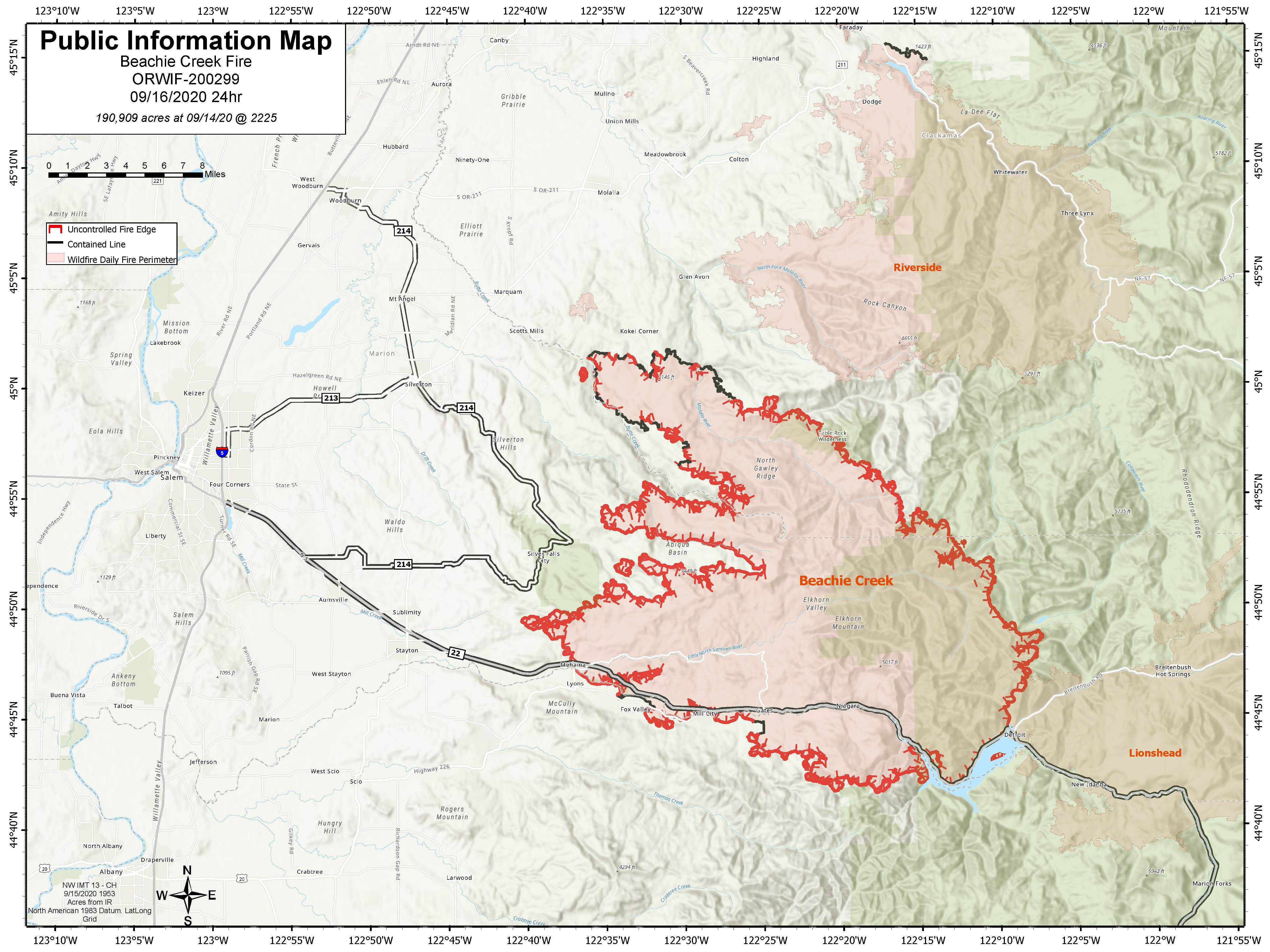
Daily Fire Update for Beachie Creek Fire September 18 2020
Related Incident:
Publication Type: News
BEACHIE CREEK FIRE UPDATE – September 18, 2020
Acres: 192,012 acres Percent Containment: 20%
Start Date: August 16, 2020 Cause: Under Investigation
Origin Location: Opal Creek Wilderness: Fuels: Timber and logging slash two miles south of Jawbone Flats, six miles north of Detroit, Oregon.
Resources: 592
Rainfall Decreases Intensity of Beachie Creek Fire
Firefighters monitor change in weather, different risks.
Salem, Ore. – The Beachie Creek fire is expected to be less active Friday as precipitation moderates fire behavior. The decrease in fire behavior and intensity today will allow firefighters to continue connecting and strengthening the containment lines around the fire. The emphasis is still protecting communities to the south and west of the fire.
Firefighters will continue to directly attack the fire around Scotts Mills, Stayton, Lyons, Mill City, and Detroit. Other crews continue work to protect timber investments on the north side of the fire near Scotts Mills.
While firefighters build containment and contingency lines, they are also monitoring for additional risks from rain such as landslides, flooding, or trees falling.
The Incident Command Team continues to address infrastructure and community needs by assisting power companies, insurance companies, and communication firms. The Team is providing these organizations with information, logistics, and transportation support. This work will lead to allowing residents and community members back into the area.
Fire officials also continue to work closely with the Marion County and Linn County Sheriff’s Offices, ODOT and the Oregon State Police to coordinate recovery efforts along the Santiam Canyon. Currently 4,056 structures are at Level 3 evacuations and another 3,499 are in level 2 evacuations. To protect first responders and communities near the fire, it is imperative that everyone heeds road closures and evacuations. Anyone who enters the fire perimeter jeopardizes firefighting and rescue operations, puts lives at risk, and potentially increases the time it will take to return residents to their homes.
The weather pattern change brings showers to the area of the fire. Rain is expected for the early part of Friday before tapering off later in the day. Maximum temperatures today will be around 65 – 70 degrees and minimum relative humidity will be over 70 percent across the fire area. Cooler temperatures with more humidity are expected over the weekend.
The Willamette National Forest, Bureau of Land Management, and State lands around the fire remain closed to the public. Go to InciWeb (link below) for more information about closures in the area.
Public information:
Facebook: facebook.com/BeachieCreek E-mail: BeachieCreek@gmail.com Phone: 541-583-0526, 8 a.m. to 8 p.m.
Inciweb https://inciweb.nwcg.gov/incident/7001/ Oregon Smoke Blog
http://oregonsmoke.blogspot.com/p/air-quality-now.html
Some state forests to reopen Friday Sept 18
Related Incident:
Publication Type: Closures
Some state forests to re-open Friday, Sept. 18
The Tillamook and Clatsop state forests will re-open to the public on Friday, Sept. 18, along with smaller ODF parcels in northwest Oregon. This also includes ODF-managed lands in Columbia, Lincoln, Polk, and Benton counties. The public is urged to know before you go about potential restrictions on campfires, off-road vehicle use and other fire prevention measures in the midst of an unprecedented fire season in Oregon.
The Gilchrist and Sun Pass state forests along with ODF-managed lands in Klamath, Jackson, Josephine, Coos, Douglas and Lane counties remain closed due to extreme fire danger.
The Santiam State Forest remains closed until further notice.
Heavy smoke on some portions of Hwy 22 as rain mixes with burning stumps
Related Incident:
Publication Type: Announcement
Drivers on State Hwy 22 should be of heavy smoke near the Beachie Creek Fire area. Rains have mixed with burning stumps to create more smoke. This will be expected for the foreseeable future.
ACTUALIZACION DEL INCENDIO BEACHIE CREEK 17 de Septiembre 2020
Related Incident:
Publication Type: News
ACTUALIZACION DEL INCENDIO BEACHIE CREEK – 17 de Septiembre 2020
Acres: 191,661 acres Contención Porcentual: 20%
Fecha de Inicio: 16 de Agosto 2020 Causa: Bajo Investigación
Ubicación de Origen: Opal Creek Wilderness: Combustibles: Madera y desechos de tala 2 millas al sur de Jawbone Flats, 6 millas norte de Detroit, Oregon. Recursos: 571
El Incendio Beachie Creek está bajo el mando del Equipo Núm. 2 de Manejo de Incidentes Tipo 1 del Area del Suroeste
El Equipo Apoya las Agencias Locales en Evaluando la Infraestructura
Salem, Ore. – El Equipo 2 de Manejo de Incidentes Tipo 1 del Area del Suroeste asumió el mando a las 7:00 de la noche el 16 de Septiembre, 2020 del Incendio Beachie Creek del Comandante de Incidente, Brian Gales del Equipo 13 y del Comandante de Incidentes del Equipo Verde de Oregon State Fire Marshall, Les Hallman.
Los combatientes y equipo pesado están trabajando en siete divisiones cual conforman el perímetro alrededor del Incendio Beachie Creek. El énfasis para el Jueves es proteger las comunidades al sur y el oeste del incendio. Los combatientes continuaran atacando directamente el fuego alrededor de Scotts Mills, Stayton, Lyons, Mill City y Detroit. Otras brigadas están trabajando para proteger las inversiones de madera en el lado oeste del incendio cerca de Scotts Mills.
Mientras los combatientes continúan construyendo líneas de contención y contingencia, el Equipo de Mando de Incidentes también está trabajando para resolver las necesidades de la infraestructura y de la comunidad asistiendo a las compañías de electricidad, compañías de seguros y empresas de comunicación. El Equipo está proporcionando información, logística y apoyo de transporte a estas empresas. Este trabajo conducirá a que se permita que los residentes y miembros de la comunidad regresen a la área.
Oficiales del incendio también continúan trabajando muy acerca con las Oficinas del Sheriff de los Condados Marion y Linn, ODOT (Departamento de Transportación de Oregon) y con la Policía Estatal de Oregon para coordinar los esfuerzos de recuperación a lo largo de Santiam Canyon. Actualmente, 4,034 estructuras están bajo Nivel 3 de evacuación y otras 3,801están bajo Nivel 2 de evacuación. Para proteger los socorristas y las comunidades cerca del incendio, es imperativo que todos obedezcan los caminos cerrados y las evacuaciones. Cualquiera que entre en el perímetro del incendio pone en peligro las operaciones de combate del incendio y rescate, ponen vidas en riesgo y potencialmente aumentado el tiempo que se tardara en devolver a los residentes a sus hogares.
El Tiempo atmosférico cambiara el Jueves a medida que se acerca un patrón meteorológico inestable trayendo tormentas eléctricas por la tarde. Antes que empiece la lluvia, los vientos aumentaran, disipando ligeramente el humo. A medida que el humo se despeje, los recursos aéreos podrán volar sobre el incendio. Para el Jueves por la noche, es probable que la lluvia aumente en la mitad del lado este del incendio. Las brigadas estarán monitoreando el tiempo atmosférico y las condiciones del fuego ya que el aumento del viento y la lluvia puede potencialmente resultar en caídas de árboles, deslizamientos, e inundaciones.
El Bosque Nacional Willamette, Bureau of Land Management, y Tierras Estatales permanecen cerrados al público. Visite InciWeb (dirección abajo) para más información sobre áreas cerradas de la zona.
Beachie Creek Fire Daily Update for September 17 2020
Related Incident:
Publication Type: News
BEACHIE CREEK FIRE UPDATE – September 17, 2020
Acres: 191,661 acres Percent Containment: 20%
Start Date: August 16, 2020 Cause: Under Investigation
Origin Location: Opal Creek Wilderness: Fuels: Timber and logging slash two miles south of Jawbone Flats, six miles north of Detroit, Oregon.
Resources: 571
Beachie Creek Fire under command of Southwest Area Type 1 Incident Management Team No. 2
Team Supports Local Agencies in Assessing Infrastructure
Salem, Ore. – The Southwest Area Type 1 Incident Management Team 2 assumed command at 7:00 PM on September 16, 2020 of the Beachie Creak Fire from Northwest Team 13 Incident Commander, Brian Gales and Oregon State Fire Marshall’s Green Team Incident Commander, Les Hallman.
Firefighters and heavy equipment are working in seven divisions that make up the perimeter around the Beachie Creek Fire. The emphasis for Thursday is to protect communities to the south and west of the fire. Firefighters will continue to directly attack the fire around Scotts Mills, Stayton, Lyons, Mill City, and Detroit. Other crews are working to protect timber investments on the north side of the fire near Scotts Mills.
While firefighters continue to build containment and contingency lines, the Incident Command Team is also working to address infrastructure and community needs by assisting power companies, insurance companies, and communication firms. The Team is providing these organizations with information, logistics, and transportation support. This work will lead to allowing residents and community members back into the area.
Fire officials also continue to work closely with the Marion County and Linn County Sheriff’s Offices, ODOT and the Oregon State Police to coordinate recovery efforts along the Santiam Canyon. Currently 4,034 structures are at Level 3 evacuations and another 3,801 are in level 2 evacuations. To protect first responders and communities near the fire, it is imperative that everyone heeds road closures and evacuations. Anyone who enters the fire perimeter jeopardizes firefighting and rescue operations, puts lives at risk, and potentially increases the time it will take to return residents to their homes.
The weather will change on Thursday as an unstable weather pattern approaches bringing late afternoon thunderstorms. Before the rain starts, winds will increase, slightly dissipating smoke. As smoke clears, aircraft will be able to fly over the fire. Thursday night, heavier rain is probable over the east half of the fire. Crews will be monitoring the weather and conditions on the fire as increased wind and rainfall can potentially result in falling trees, landslides, and flashfloods.
The Willamette National Forest, Bureau of Land Management, and State lands around the fire remain closed to the public. Go to InciWeb (link below) for more information about closures in the area.
Public information:
Facebook: facebook.com/BeachieCreek E-mail: BeachieCreek@gmail.com Phone: 541-583-0526, 8 a.m. to 8 p.m.
Inciweb https://inciweb.nwcg.gov/incident/7001/ Oregon Smoke Blog
http://oregonsmoke.blogspot.com/p/air-quality-now.html
Actualizacin del Incendio Beachie Creek Para el Mircoles 16 de Septiembre
Related Incident:
Publication Type: News
Salem, Ore. – Los combatientes continuar haciendo buen progreso asegurando el perímetro del Incendio Beachie Creek. Como resultado a sus esfuerzos, el incendio esta 20% contenido. Tras una evaluación extensiva, por parte de las brigadas, los oficiales han determinado que 470 residencias, 35 estructuras comerciales, y 783 estructuras menores no residenciales fueros destruidas por el incendio. Adicionalmente, 46 residencias, 5 estructuras comerciales, y 83 estructuras menores no residenciales, fueron dañadas.
Las brigadas y equipo pesado continúan trabajando para conectar y reforzar las líneas de control en el lado oeste y noroeste del incendio. Los combatientes continúan trabajando con los dueños de las tierras en el perímetro sureste del incendio para asegurar las líneas de control. El aumento de acres del incendio en las últimas 24 horas, no se debe a la propagación del incendio sino a que se están realizando evaluaciones aéreas, así proporcionando medidas mas precisas y un mejor mapeo. La transferencia de mando del Equipo 13 de Manejo de Incidentes del Noroeste (Northwest Incident Management Team 13) al Equipo 2 de Manejo de Incidentes del Suroeste (Southwest Incident Management Team 2) se llevará a cabo hoy al anochecer. Estos equipos han estado trabajando juntos las ultimas 24 horas para asegurar una transición impecable de mando.
El Incendio Beachie Creek y el Incendio Riverside aún permanecen como una milla de separados. Los oficiales de estos incendios cercanos están coordinando estrategias para minimizar el crecimiento y estabilizar estos incendios. La vegetación extremamente seca y la falta de características naturales de retención en Table Rock Wilderness y áreas circundantes significa que aún existe la posibilidad que estos incendios se junten. Basado en el tiempo atmosférico actual, se anticipa que una futura junta de esos dos incendios no resultara en un comportamiento de fuego dinámico como se vio en la última semana.
Los oficiales del incendio continúan trabajando muy acerca con la Oficina del Sheriff del Condado Marion, ODOT (Departamento de Transportación de Oregon) y con la Policía Estatal de Oregon para coordinar los esfuerzos de recuperación a lo largo del Santiam Canyon. Actualmente 5,845 estructuras están bajo Nivel 3 de evacuación y otras 3,961 casas están bajo Nivel 2 de evacuación. Es imperativo proteger los socorristas y comunidades en el paso de incendio que todos obedezcan las evacuaciones y cierres de caminos establecidos por oficiales del incendio y la ley. Cualquiera que entre en el perímetro del incendio está poniendo en peligro las operaciones de combate del incendio y rescate, ponen vidas en riesgo y potencialmente aumentado el tiempo que se tardara en devolver a los residentes a sus comunidades.
TIEMPO ATMOSFERICO: El Miércoles empezará con otra tapa de neblina cual probablemente se disipará par al medio día. Se espera que hoy esté más caliente y reseco con temperaturas en los 70 grados, se pronostica un humedad relativa mínima de entre 35-50 por ciento a través del incendio, y tan bajo como el 25 por ciento en los cerros. Esto puede resultar que el comportamiento del fuego aumente. Se pronostica un sistema de baja presión cual traerá lluvia al área el Jueves por la noche y el Viernes.
SEGURIDAD: Se les aconseja los miembros del público que obedezcan las órdenes de evacuación emitidas por la Oficina del Sheriff del Condado y sistemas de notificación de emergencia. Conozca cada nivel de Ready, Set, Go (Alistar, Poner, Vallase) Ready-Alistar sus pertenencias; Set-Poner sus cosas en la puerta o poner en el automóvil, Go-Vallase inmediatamente.
HUMO: Otras ves hoy, el humo continuara pesado a través del área del Incendio Beachie Creek. Esto conducirá a condiciones “insanas” y posiblemente “peligrosas”. Personas con problemas respiratorios pueden verse afectadas por el humo intenso. Los niveles de humo pueden cambiar rápidamente dependiendo en el tiempo atmosférico. Revise las condiciones actuales del aire en DEQ’s Air Quality Index (Índice de Calidad del Aire) bajando la aplicación OregonAIR gratis en su smartphone.
CERRADOS: Todo el Bosque Nacional Willamette está cerrado a todo tipo de recreación incluyendo áreas para acampar, senderos, áreas de uso de día y rampas para barcos. Los caminos del bosque están cerrados para el público a menos que estén siendo utilizados para evacuar. Tierras del Bureau of Land Management (BLM) en la vecindad del incendio y tierras Estales administradas por el Departamento Forestal de Oregon (Oregon Department of Forestry -ODF) incluyendo el Bosque Estatal de Santiam (Santiam State Forest) también están cerrados para el público. Visite InciWeb (dirección abajo) para más información sobre áreas cerradas de la zona.
Beachie Creek Fire Update for Wednesday September 16 2020
Related Incident:
Publication Type: News
Beachie Creek Fire Update for Wednesday, September 16, 2020
Brian Gales, Incident Commander, NWIMT13
Les Hallman, Incident Commander, OSFM
Start date: Aug, 16, 2020
Location: Santiam Canyon west of Detroit, OR, Southern Clackamas County
Cause: Unknown
Fire size: 191,238 acres
Air Assets Assigned: 7
Total personnel: 530
Salem, Ore. –Firefighters continue to make good progress securing the perimeter of the Beachie Creek Fire. As a result of their efforts, the fire is 20% contained. Following an extensive assessment by crews, fire officials determined that 470 residences, 35 commercial structures, and 783 minor nonresidential structures were destroyed by the fire. Additionally, 46 residences, 5 commercial structures, and 83 minor nonresidential structures were damaged.
Crews and heavy equipment continue to connect and strengthen control line on the west and northwest sides of the fire. Firefighters continue to work with landowners on the southeastern perimeter to secure control lines. The increased acreage in fire size is not due to fire spread over the past 48 hours but because aerial assessments are being completed, providing more accurate measurements and improved mapping. Transfer of command from Northwest Incident Management Team 13 to Southwest Incident Management Team 2 will take place this evening. The teams have been working closely over the last 24 hours to ensure a seamless transition of command.
The Beachie Creek Fire and the Riverside Fire remain about one mile apart. Officials from nearby fires are coordinating strategies to minimize fire growth and stabilize incidents. Extremely dry vegetation and a lack of natural holding features in the Table Rock Wilderness and surrounding areas mean it is still possible the fires could burn together. Based on current weather, it is anticipated that a future merger would not result in dynamic fire behavior as seen last week.
Fire officials are working closely with the Marion County Sheriff’s Office, ODOT and the Oregon State Police to coordinate recovery efforts along the Santiam Canyon. Currently 5,845 structures are at Level 3 evacuations and another 3,961 are in level 2 evacuations. It is imperative to protect first responders and communities that everyone heeds fire and law enforcement road closures and evacuations. Anyone who enters the fire perimeter jeopardizes firefighting and rescue operations, puts lives at risk, and potentially increases the time it will take to return residents to their communities.
WEATHER: Wednesday will begin with another fog layer likely to dissipate by mid-day. It is expected to be hotter and drier today with temperatures in the 70s, forecasted minimum relative humidity of 35-50 percent across the fire, and as low as 25 percent on ridges. This could result in an increase in fire behavior. A low pressure system bringing rain to the area is forecasted for Thursday night and Friday.
SAFETY: Members of the public are encouraged to heed local evacuation orders issued by the county sheriff’s office and emergency notification systems. Know the Ready, Set, Go levels and make appropriate preparations. READY your belongings; SET your things at the door or prepack them in your car; GO and leave immediately.
SMOKE: Smoke will continue to be heavy across the area of the Beachie Creek Fire again today. This will lead to “unhealthy” and possibly “hazardous” conditions. Individuals with respiratory issues may find themselves affected by the intense smoke. Smoke levels can change rapidly depending on weather. Check current conditions on DEQ's Air Quality Index or by downloading the free OregonAIR app on your smartphone.
CLOSURES: The entire Willamette National Forest is closed to all recreation including campgrounds, trails, days use areas, and boat ramps. Roads on the forest are closed to the public unless being used to evacuate. Bureau of Land Management (BLM) lands in the vicinity of the fire and State lands managed by Oregon Department of Forestry (ODF) including the Santiam State Forest are also closed to the public. Go to InciWeb (link below) for more information about closures in the area