
Actualizacin del Incendio Beachie Creek para el Martes 15 de Sept 2020
Related Incident:
Publication Type: News
Actualización del Incendio Beachie Creek para el Martes 15 de Septiembre, 2020
Salem, Ore. – El aumento de acres en el tamaño del incendio hoy no se debe a la propagación del fuego en las ultimas 24 horas, sino a que se hizo una evolución aérea. Esto permitió una medida más precisa y un mapeo mejor. Los combatientes continuaran trabajando el Martes asegurando el perímetro del Incendio Beachie Creek. Las brigadas y equipo pesado continuaran conectando y fortaleciendo la línea de control existente en la porción oeste y noroeste del incendio. En los últimos par de días se ah logro buen progreso en esta área. Los combatientes continúan trabajando con los dueños de las tierras en el perímetro sureste del incendio construyendo y asegurando líneas de control en esa área. Los combatientes continuaran con la liquidación y evaluando sistemáticamente los daños a las estructuras dentro del incendio. Debido a estos esfuerzos, los combatientes han logrado un 15% de contención.
El Incendio Beachie Creek y el Incendio Riverside aun permanecen como un milla de separados. Los oficiales de los incendios cercanos están coordinando estrategias para minimizar el crecimiento y estabilizar los incendios. Debido a la vegetación extremadamente seca y la falta de características de retención natural en Table Rock Wilderness y las áreas circundantes significa que aún es posible que estos dos incendios ardan juntos. Basado en el tiempo atmosférico actual, se anticipa que si estos dos incendios se juntan en el futuro no resultara en un comportamiento dinámico de fuego tal como fue visto la semana pasada.
Los oficiales del incendio continúan trabajando muy acerca con la Oficina del Sheriff del Condado Marion, ODOT (Departamento de Transportación de Oregon) y con la Policía Estatal de Oregon para coordinar los esfuerzos de recuperación a lo largo del Santiam Canyon. Actualmente 16,776 estructuras están bajo Nivel 3 de evacuación y otras 18,528 casas están bajo Nivel 2 de evacuación. Es imperativo proteger los socorristas y comunidades en el paso del incendio y que todos obedezcan las evacuaciones y caminos cerrados establecidos por oficiales del incendio y la ley. Cualquiera que entre en el perímetro del incendio está poniendo en peligro las operaciones de combate del incendio y rescate, pone vidas en peligro, y potencialmente aumentado el tiempo que se tardara para devolver a los residentes a sus comunidades.
TIEMPO ATMOSFERICO: Probablemente las inversiones persistirán en el lado oeste del incendio el Martes. Las altas temperaturas estarán entre los altos 60s y bajos 70s, con una humedad relativa mínima pronosticada en 50 - 60 por ciento en el lado oeste del incendio. Se espera que la humedad relativa sea más baja, de 30-45 por ciento, en el lado este del incendio y en elevaciones encima de 2,500 pies. Se predice que el patrón del tiempo atmosférico cambiara en las siguientes 24 horas, con la posibilidad de lluvia en el lado oeste del incendio. El sistema meteorológico pronosticaba lluvia para el Martes pero se detuvo y está muy retirado hacia el oeste para agregar precipitación al incendio. Un sistema de baja presión esta pronosticado para esta semana con una mayor posibilidad de lluvia.
SEGURIDAD: Se les aconseja los miembros del público que obedezcan las órdenes de evacuación emitidas por la Oficina del Sheriff del Condado y sistemas de notificación de emergencia. Conozca cada nivel de Ready, Set, Go (Alistar, Poner, Vallase) Ready-Alistar sus pertenencias; Set-Poner sus cosas en la puerta o en el automóvil, Go-Vallase inmediatamente.
HUMO: Otra vez hoy, el humo continuara pesado a través del área del Incendio Beachie Creek. Esto conducirá a condiciones “insanas” y posiblemente “peligrosas”. Personas con problemas respiratorios pueden verse afectadas por el humo intenso. Algún movimiento de nubes de medio nivel tal vez permitan un ligero mejoramiento a la calidad del aire el Martes al medio día. Los niveles de humo pueden cambiar rápidamente dependiendo en el tiempo atmosférico. Revise las condiciones actuales del aire en DEQ’s Air Quality Index (Índice de Calidad del Aire) bajando la aplicación OregonAIR gratis en su smartphone.
CERRADOS: Todo el Bosque Nacional Willamette está cerrado a todo tipo de recreación incluyendo áreas para acampar, senderos, áreas de uso de día y rampas para barcos. Los caminos del bosque están cerrados para el público a menos que estén siendo utilizados para evacuar. Tierras del Bureau of Land Management (BLM) en la vecindad del incendio y tierras Estales administradas por el Departamento Forestal de Oregon (Oregon Department of Forestry -ODF) incluyendo el Bosque Estatal de Santiam (Santiam State Forest) también están cerrados para el público. Visite InciWeb (dirección abajo) para más información sobre áreas cerradas de la zona.
Información pública:
Facebook: facebook.com/BeachieCreek
E-mail: BeachieCreek@gmail.com Phone: 541-583-0526, 8 a.m. to 8 p.m.
Inciweb
https://inciweb.nwcg.gov/incident/7001/
Oregon Smoke Blog http://oregonsmoke.blogspot.com/p/air-quality-now.html
Beachie Creek Fire Update for Tuesday September 15 2020
Related Incident:
Publication Type: News
Beachie Creek Fire Update for Tuesday, September 15, 2020
Brian Gales, Incident Commander, NWIMT13
Les Hallman, Incident Commander, OSFM
Start date: Aug, 16, 2020
Location: Santiam Canyon west of Detroit, OR, Southern Clackamas County
Cause: Unknown
Fire size: 190,138 acres
Air Assets Assigned: 7
Total personnel: 572
Salem, Ore. – The increased acreage in fire size reported today is not due to fire spread over the past 24 hours but because an aerial assessment was completed. This allowed for a more accurate measure and improved mapping of the fire. Firefighters will resume work Tuesday to secure the perimeter of the Beachie Creek Fire. Crews and heavy equipment continue to connect and strengthen existing control line together on the west and northwest portions of the fire. Good progress was made in this area over the last couple days. Firefighters continue to work with landowners on the southeastern perimeter of the fire to build and secure control lines in that area. Firefighters will also continue mopping up and systematically assessing damage to structures inside the fire. Due to these efforts, firefighters have achieved 15% containment.
The Beachie Creek Fire and the Riverside Fire remain about one mile apart. Officials from nearby fires are coordinating strategies to minimize fire growth and stabilize incidents. Extremely dry vegetation and a lack of natural holding features in the Table Rock Wilderness and surrounding areas mean it is still possible the fires could burn together. Based on current weather, it is anticipated that a future merger would not result in dynamic fire behavior as seen last week.
Fire officials are working closely with the Marion County Sheriff’s Office, ODOT and the Oregon State Police to coordinate recovery efforts along the Santiam Canyon. Currently 16,776 structures are at Level 3 evacuations and another 18,528 homes in level 2 evacuations. It is imperative to protect first responders and communities in the path of the fire that everyone heeds fire and law enforcement road closures and evacuations. Anyone who enters the fire perimeter jeopardizes firefighting and rescue operations, puts lives at risk, and potentially increases the time it will take to return residents to their communities.
WEATHER: Inversions are likely to persist on the west side of the fire on Tuesday. High temperatures will be in the upper 60s to low 70s, with forecasted minimum relative humidity of 50 - 60 percent on the west side of the fire. Relative humidity is expected to be lower, 30-45 percent, on the east side of the fire and at elevations above 2,500 feet. The weather system forecasted to bring rain on Tuesday stalled and is too far west to add moisture to the fire. A low pressure system is forecasted for later this week with higher chances of rain.
SAFETY: Members of the public are encouraged to heed local evacuation orders issued by the county sheriff’s office and emergency notification systems. Know the Ready, Set, Go levels and make appropriate preparations. READY your belongings; SET your things at the door or prepack them in your car; GO and leave immediately.
SMOKE: Smoke will continue to be heavy across the area of the Beachie Creek Fire again today. This will lead to "unhealthy" and possibly "hazardous" conditions. Individuals with respiratory issues may find themselves affected by the intense smoke. Some mid-level cloud movement may allow for slight improvements to air quality mid-day, Tuesday. Smoke levels can change rapidly depending on weather. Check current conditions on DEQ's Air Quality Index or by downloading the free OregonAIR app on your smartphone.
Public information:
Facebook: facebook.com/BeachieCreek
E-mail: BeachieCreek@gmail.com Phone: 541-583-0526, 8 a.m. to 8 p.m.
Oregon Smoke Blog: http://oregonsmoke.blogspot.com/p/air-quality-now.html
Inciweb: https://inciweb.nwcg.gov/incident/7001/
Closure Order for Northwest Oregon BLM Lands
Related Incident:
Publication Type: Closures
EMERGENCY CLOSURE OF PUBLIC LANDS:
AGENCY: Bureau of Land Management, Northwest Oregon District, Oregon.
ACTION: Temporary Closure of Public Lands
SUMMARY: Pursuant to 43 CFR 9268.3(d) and 43 CFR 8364.1, the Bureau of Land Management (BLM) hereby provides notice that effective immediately, the public lands described below are closed to all forms of public access. This action is in response to large fires currently active in the area. The BLM is closing public lands in order to reduce conflicts with emergency crews and allow for fire suppression and burned area site recovery.
AFFECTED AREA: All BLM-managed public lands, roads, sites, and trails east of Interstate 5 in the following counties: Lane County, Linn County, Marion County, Clackamas County, Multnomah County. Also, BLM-managed public lands in Lincoln County are closed, with the exception of Yaquina Head Outstanding Natural Area.
DATES: This closure is effective immediately and will remain in effect until such time as conditions allow for safe use of the public lands.
FOR FURTHER INFORMATION CONTACT: David Howell, Associate District Manager, 1717 Fabry Road SE, Salem, OR 97306, telephone (503) 375-5646.
DISCUSSION OF THE RULES: The public must not enter the closure area. All uses within the closure area are prohibited. Exceptions to these prohibitions are noted below under Exemptions. Incidents of extreme fire behavior and extreme fire danger have been observed throughout the District. You must not enter closed recreation sites. Recovery of these areas is expected to continue into next year, 2021.
EXEMPTIONS: The following persons are exempt from the provisions of this Order:
1. Any Federal, State, or Local Officer, or member of an organized medical, rescue or firefighting force engaged in fire, emergency, or law enforcement activities, or public utility employees engaged in emergency repairs.
2. BLM employees, contractors, or agents engaged in official duties:
3. Individuals operating within the scope of their official and legitimate governmental duties.
4. Parties who carry written approval signed by the BLM Authorized Officer (Field Manager or District Manager) allowing access to the described public lands.
PENALTIES:
Any person who violates this may be tried before a United States Magistrate and fined in accordance with 18 U.S.C. 3571, imprisoned for no more than 12 months, or both. Vehicles found in violation of this order may be removed.
EFFECTIVE: This Order is effective immediately upon signature.
September 10, 2020
Public use closure for ODFmanaged state forests extended thru Wed Sep 16
Related Incident:
Publication Type: Closures
Public use closure for ODF-managed state forests extended through Wed., Sept. 16
September 14, 2020, ODF Public Affairs
SALEM, Ore. — All Oregon Department of Forestry-managed forests are closed to public use through at least Wed, Sept. 16. Fire danger remains extreme, air quality is bad to hazardous, & last week’s wind storms caused downed trees on roads & other safety problems that need to be cleared. This covers the Tillamook, Clatsop, Gilchrist, Sun Pass & Santiam state forests as well as other smaller parcels managed by ODF in Lane, Douglas, Coos, Jackson, Josephine, Klamath, Polk, Lincoln, & Benton counties.
ODF appreciates the public’s understanding.
Actualizacin del Incendio Beachie Creek para el Lunes 14 de Sept 2020
Related Incident:
Publication Type: News
Actualización del Incendio Beachie Creek para el Lunes 14 de Septiembre, 2020
Brian Gales, Incident Commander, NWIMT13
Les Hallman, Incident Commander, OSFM
Fecha de inicio: 16 de Agosto, 2020
Ubicación: Santiam Canyon Oeste de of Detroit, OR,
Sur del Condado Clackamas
Causa: Desconocida
Tamaño del incendio: 190,138 acres
Recursos Aéreos Asignados: 7
Personal total: 572
Salem, Ore. – Los combatientes continuaran el trabajo el Lunes para asegurar el perímetro del Incendio Beachie Creek. Brigadas y equipo pesado están trabajando para unir los trozos existentes en la línea de control en las partes del oeste y noroeste del incendio. Los esfuerzos de construcción de línea y reforzarla cual iniciaron el sábado al sur de la Carretera 22 continuaran. Los combatientes continúan trabajando con los dueños de las tierras en el perímetro sureste del incendio construyendo y asegurando líneas de control en esa área. El Domingo los combatientes comenzaron la liquidación y sistemáticamente evaluando los daños a las estructuras dentro del incendio y continuaran con esos esfuerzos hoy.
El Incendio Beachie Creek y el Incendio Riverside permanecen como una milla de separados. Los oficiales de los incendios cercanos están coordinando estrategias para minimizar el crecimiento y estabilizar los incendios. La combinación actual de vientos, sequia historial de los bosques y la falta de características de retención natural en Table Rock Wilderness y las áreas circundantes significa que todavía existe la posibilidad de que estos incendios puedan arder juntos. Basado en el tiempo atmosférico actual, se anticipa que si estos dos incendios se juntan en el futuro no resultara en un comportamiento dinámico de fuego tal como fue visto la semana pasada.
Los oficiales del incendio continúan trabajando muy acerca con la Oficina del Sheriff del Condado Marion, ODOT (Departamento de Transportación de Oregon) y con la Policía Estatal de Oregon para coordinar los esfuerzos de recuperación a lo largo del Santiam Canyon. Actualmente 16,776 estructuras están bajo Nivel 3 de evacuación y otras 18,528 casas están bajo Nivel 2 de evacuación. Es imperativo proteger los socorristas y comunidades en el paso de incendio que todos obedezcan las evacuaciones y cierres de caminos establecidos por oficiales del incendio y la ley. Cualquiera que entre en el perímetro del incendio está poniendo en peligro las operaciones de combate del incendio y rescate, pone vidas en peligro, y potencialmente aumentado el tiempo que se tardara para devolver a los residentes a sus comunidades.
TIEMPO ATMOSFERICO: Es probable que de nuevo las inversiones en el valle persistan a lo largo del día. Para el Lunes las altas temperaturas estarán dentro de los altos 60s a los bajos 70s, con humedad relativa mínima pronosticada en 40-50 por ciento en el lado oeste del incendio. Se espera que la humedad relativa sea mucho mas baja, de 30-45 por ciento en el lado este del incendio y en elevaciones encima de 2,500 pies. Se predice que el patrón del tiempo atmosférico cambiara en las siguientes 24 horas, con la posibilidad de lluvia en el lado oeste del incendio.
SEGURIDAD: Se les aconseja los miembros del público que obedezcan las órdenes de evacuación emitidas por la Oficina del Sheriff del Condado y sistemas de notificación de emergencia. Conozca cada nivel de Ready, Set, Go (Alistar, Poner, Vallase) Ready-Alistar sus pertenencias; Set-Poner sus cosas en la puerta o en el automóvil, Go-Vallase inmediatamente.
HOMO: Otra vez hoy, el humo continuara pesado a través del área del Incendio Beachie Creek. Esto conducirá a condiciones “insanas” y posiblemente “peligrosas”. Personas con problemas respiratorios pueden verse afectadas por el humo intenso. En áreas más cercanas al incendio – cerca de Detroit, Florence, Chiloquin and Eugene – tendran los peores impactos de humo. Los niveles de humo pueden cambiar rápidamente dependiendo en el tiempo atmosférico. Revise las condiciones actuales del aire en DEQ’s Air Quality Index (Índice de Calidad del Aire) bajando la aplicación OregonAIR gratis en su smartphone.
CERRADOS: Caminos del Bosque Willamette, senderos y tierras alrededor del área del incendio están cerradas. Ver la orden oficial (Order 06-18- 04-20-13). Tierras de Bureau of Land Management (BLM) en la vecindad del incendio, y tierras Estatales administradas por el Departamento Forestal de Oregon (Oregon Department of Forestry) incluyendo el Bosque Estatal de Santiam (Santiam State Forest) también están cerrados al público. Visite InciWeb (dirección abajo) para la lista y mapa de caminos, senderos y sitios de recreación cerrados.
Información pública:
Facebook: facebook.com/BeachieCreek
E-mail: BeachieCreek@gmail.com
Phone: 541-583-0526, 8 a.m. to 8 p.m.
Inciweb: https://inciweb.nwcg.gov/incident/7001/
Oregon Smoke Blog: http://oregonsmoke.blogspot.com/p/air-quality-now.html
Beachie Creek Fire Update for Monday September 14 2020
Related Incident:
Publication Type: News
Beachie Creek Fire Update for Monday, September 14, 2020
Brian Gales, Incident Commander, NWIMT13
Les Hallman, Incident Commander, OSFM
Start date: Aug, 16, 2020
Location: Santiam Canyon west of Detroit, OR, Southern Clackamas County
Cause: Unknown
Fire size: 190,138 acres
Air Assets Assigned: 7
Total personnel: 572
Salem, Ore. – Firefighters will resume work on Monday to secure the perimeter of the Beachie Creek Fire. Crews and heavy equipment are working to tie the pieces of existing control line together on the west and northwest portions of the fire. Line construction and reinforcement efforts which began Saturday south of Highway 22 will continue. Firefighters continue to work with landowners on the southeastern perimeter of the fire to build and secure control lines in that area. Firefighters began mopping up and systematically assessing damage to structures inside the fire on Sunday and will continue those efforts today.
The Beachie Creek Fire and the Riverside Fire remain about one mile apart. Officials from nearby fires are coordinating strategies to minimize fire growth and stabilize incidents. The combination of winds, record dry forests, and a lack of natural holding features in the Table Rock Wilderness and surrounding areas mean it is still possible the fires could burn together. Based on current weather, it is anticipated that a future merger would not result in dynamic fire behavior as seen last week.
Fire officials are working closely with the Marion County Sheriff’s Office, ODOT and the Oregon State Police to coordinate recovery efforts along the Santiam Canyon. Currently 16,776 structures are at Level 3 evacuations and another 18,528 homes in level 2 evacuations. It is imperative to protect first responders and communities in the path of the fire that everyone heeds fire and law enforcement road closures and evacuations. Anyone who enters the fire perimeter jeopardizes firefighting and rescue operations, puts lives at risk, and potentially increases the time it will take to return residents to their communities.
WEATHER: Valley inversions are likely to persist through the day again. High temperatures Monday will generally be in the upper 60s to low 70s, with forecast minimum relative humidity of 45-55 percent on the west side of the fire. Relative humidity is expected to be much lower, 30-45 percent, on the east side of the fire and at elevations above 2,500 feet. The weather pattern is predicted to change in the next 24 hours, with a chance of rain on the west side of the fire.
SAFETY: Members of the public are encouraged to heed local evacuation orders issued by the county sheriff’s office and emergency notification systems. Know the Ready, Set, Go levels and make appropriate preparations. READY your belongings; SET your things at the door or prepack them in your car; GO and leave immediately.
SMOKE: Smoke will continue to be heavy across the area of the Beachie Creek Fire again today. This will lead to “unhealthy” and possibly “hazardous” conditions. Individuals with respiratory issues may find themselves affected by the intense smoke. Areas closest to fires - near Detroit, Florence, and Eugene – will have severe smoke impacts. Smoke levels can change rapidly depending on weather.
Check current conditions on DEQ's Air Quality Index or by downloading the free OregonAIR app on your smartphone.
CLOSURES: Willamette National Forest roads, trails, and lands around the fire area are closed. View the official order (Order 06-18- 04-20-13). Bureau of Land Management (BLM) lands in the vicinity of the fire and State lands managed by Oregon Department of Forestry (ODF) including the Santiam State Forest are also closed to the public. Go to InciWeb (link below) for a list and map of closed areas, roads, trails, and recreation sites.
Public information:
Facebook: facebook.com/BeachieCreek
E-mail: BeachieCreek@gmail.com Phone: 541-583-0526, 8 a.m. to 8 p.m.
Inciweb: https://inciweb.nwcg.gov/incident/7001/
Oregon Smoke Blog: http://oregonsmoke.blogspot.com/p/air-quality-now.html
Actualizacin del Incendio Beachie Creek para el Domingo 13 de Sept 2020
Related Incident:
Publication Type: News
Actualización del Incendio Beachie Creek para el Domingo 13 de Septiembre, 2020
Brian Gales, Incident Commander, NWIMT13
Les Hallman, Incident Commander, OSFM
Fecha de Inicio: 16 de Agosto, 2020
Ubicación: Santiam Canyon Oeste de Detroit, OR. Sur del Condado Clackamas
Causa: Desconocida
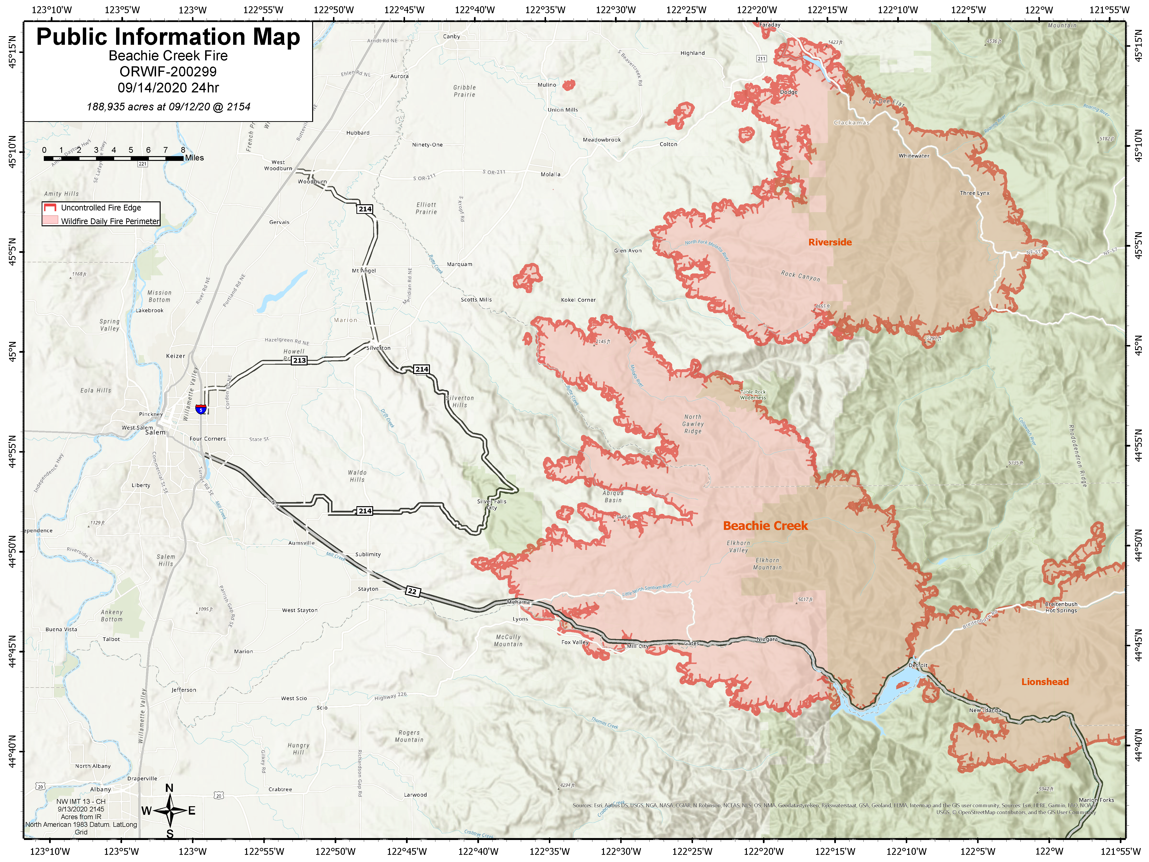
Tamaño del incendio: 188,935 acres
Recursos Aéreos Asignados: 7
Personal total: 563
Salem, Ore. – Una vez que la neblina empiece a disiparse el Domingo, los combatientes resumirán el trabajo alrededor del perímetro del Incendio Beachie Creek. Los combatientes empezaran la liquidación y evaluar sistemáticamente los daños a las estructuras dentro del incendio. Brigadas y equipo pesado trabajaran el Domingo para unir los trozos existentes en la línea de control en las partes del oeste y noroeste del incendio. Los esfuerzos de construcción de línea y refuerzos cual iniciaros el Sábado al sur de la carretera 22 continuaran el Domingo. Los combatientes están trabajando con los dueños de las tierras en el perímetro sureste del incendio construyendo línea de control a lo largo de esa sección del incendio.
El Incendio Beachie Creek y el Incendio Riverside permanecen como una milla de separados. A pesar de los rumores, que estos dos incendios se junten no es inminente. La combinación actual de vientos, sequia historial de los bosques y la falta de características de retención natural en Table Rock Wilderness y las áreas circundantes significa que todavía es posible que los dos incendios puedan arder juntos en los próximos días. Basado en el tiempo atmosférico actual, se anticipa que una futura junta de esos dos incendios no resultaría en un comportamiento de fuego dinámico como se vio en la última semana.
Los oficiales del incendio continúan trabajando muy acerca con la Oficina del Sheriff del Condado Marion, ODOT (Departamento de Transportación de Oregon) y con la Policía Estatal de Oregon para coordinar los esfuerzos de recuperación a lo largo del Santiam Canyon. Actualmente 16,776 estructuras están bajo Nivel 3 de evacuación y otras 18,528 casas están bajo Nivel 2 de evacuación. Es imperativo proteger los socorristas y comunidades en el paso de incendio que todos obedezcan las evacuaciones y cierres de caminos establecidos por oficiales del incendio y la ley. Cualquiera que entre en el perímetro del incendio está poniendo en peligro las operaciones de combate del incendio y rescate, así como aumentado el tiempo que se tardara en devolver a los residentes a sus comunidades y poniendo vidas en riesgo.
TIEMPO ATMOSFERICO: La alta presión de encima continuara debilitándose lentamente el Domingo y el Lunes. Eso significa que podría mejorar la calidad general del aire el domingo por la tarde, pero es probable que las inversiones en el valle sean persistentes a lo largo del día. Altas temperaturas el Domingo generalmente estarán en los altos 60s a los bajos 70s, con humedad relativa mínima pronosticada en 40-50 por ciento. Se predice que el patrón metrológico cambie a los principios de la semana que viene con una buena oportunidad de lluvia para el Lunes en la noche y el Martes.
SEGURIDAD: Se les aconseja los miembros del público que obedezcan las órdenes de evacuación emitidas por la Oficina del Sheriff del Condado y sistemas de notificación de emergencia. Conozca cada nivel de Ready, Set, Go (Alistar, Poner, Vallase) Ready-Alistar sus pertenencias; Set-Poner sus cosas en la puerta o poner en el automóvil, Go-Vallase inmediatamente.
HUMO: Otra vez el Domingo, el humo continuara pesado a través del área del Incendio Beachie Creek. Esto conducirá a condiciones “insanas” y posiblemente “peligrosas”. Personas con problemas respiratorios pueden verse afectadas por el humo intenso. En áreas más cercanas al incendio – cerca de Detroit, Florence, Chiloquin and Eugene – tienen los peores impactos de humo. Los niveles de humo pueden cambiar rápidamente dependiendo en el tiempo atmosférico. Revise las condiciones actuales del aire en DEQ’s Air Quality Index (Índice de Calidad del Aire) bajando la aplicación OregonAIR gratis en su smartphone.
CERRADOS: : Caminos del Bosque Willamette, senderos y tierras alrededor del área del incendio están cerradas. Ver la orden oficial (Order 06-1804- 20-13) or go to InciWeb (link below) for a list and map of the closed roads, trails, and recreation sites.
Información pública:
Facebook: facebook.com/BeachieCreek
E-mail: BeachieCreek@gmail.com Telefono: 541-583-0526, 8 a.m. to 8 p.m.
Inciweb: https://inciweb.nwcg.gov/incident/7001/
Oregon Smoke Blog http://oregonsmoke.blogspot.com/p/air-quality-now.html
All state forests closed to public use due to fire danger
Related Incident:
Publication Type: Closures
Contact:
Jason Cox, ODF Public Affairs Specialist, 503-945-7427, jason.r.cox@oregon.gov
All state forests closed to public use due to fire danger
SALEM, Ore. — All ODF-managed forestland is currently closed to public entry and use, including the Santiam, Tillamook, Clatsop, Gilchrist and Sun Pass state forests.
This also includes ODF-managed forestlands in Lane, Douglas, Coos, Jackson, Josephine, Klamath, Polk, Lincoln, & Benton counties. The Tillamook and Clatsop closures are until at least Sunday, Sept. 13 at 11 p.m. All other closures are until further notice. Closure is necessary due to the current extreme fire conditions that are endangering life, forest resources, and property as well as very limited fire and emergency response resources.
Beachie Creek Fire Information Update for September 13 2020
Related Incident:
Publication Type: News
Beachie Creek Fire Update for Sunday, September 13, 2020
Brian Gales, Incident Commander, NWIMT13
Les Hallman, Incident Commander, OSFM
Start date: Aug, 16, 2020
Location: Santiam Canyon west of Detroit, OR, Southern Clackamas County
Cause: Unknown
Fire size: 188,935 acres
Air Assets Assigned: 7
Total personnel: 563
Salem, Ore. – Once the dense fog begins to dissipate, firefighters will resume work Sunday around the perimeter of the Beachie Creek Fire. Firefighters will begin mopping up and systematically accessing damage to structures inside the fire. Crews and heavy equipment will work Sunday to tie the pieces of existing control line together on the west and northwest portions of the fire. Line construction and reinforcement efforts which began Saturday south of Highway 22 will continue Sunday. Firefighters are working with landowners on the southeastern perimeter of the fire to build and secure control lines along that section of the fire.
The Beachie Creek Fire and the Riverside Fire remain about one mile apart. Despite the rumors, a merger of the two fires is not imminent. The current combination of winds, record dry forests, and a lack of natural holding features in the Table Rock Wilderness and surrounding areas mean it is still possible the fires could burn together in the coming days. Based on current weather, it is anticipated that a future merger would not result in dynamic fire behavior as seen in the last week.
Fire officials continue to work closely with the Marion County Sheriff’s Office, ODOT and the Oregon State Police to coordinate recovery efforts along the Santiam Canyon. Currently 16,776 structures are at Level 3 evacuations and another 18,528 homes in level 2 evacuations. It is imperative to protect first responders and communities in the path of the fire that everyone heeds fire and law enforcement road closures and evacuations. Anyone who enters the fire perimeter is jeopardizing firefighting and rescue operations, increasing the time it will take to return residents to their communities and putting lives at risk.
WEATHER: High pressure aloft will continue to slowly weaken Sunday and Monday. That means there could be some improvement in overall air quality Sunday afternoon, but valley inversions are likely to be persistent through the day. High temperatures Sunday will generally be in the upper 60s to low 70s, with forecast minimum relative humidity of 40-50 percent. The weather pattern is predicted to change early next week, with a good change of some rain Monday night and Tuesday.
SAFETY: Members of the public are encouraged to heed local evacuation orders issued by the county sheriff’s office and emergency notification systems. Know each Ready, Set, Go levels and make appropriate preparations. READY your belongings; SET your things at the door or prepack them in your car; GO and leave immediately.
SMOKE: Smoke will continue to be heavy across the area of the Beachie Creek Fire again on Sunday. This will lead to “unhealthy” and possibly “hazardous” conditions. Individuals with respiratory issues may find themselves affected by the intense smoke. Areas closest to fires - near Detroit, Florence, Chiloquin and Eugene - are having the worst smoke impacts. Smoke levels can change rapidly depending on weather. Check current conditions on DEQ's Air Quality Index or by downloading the free OregonAIR app on your smartphone.
CLOSURES: Willamette National Forest roads, trails, and lands around the fire area are closed. View the official order (Order 06-18-04-20-13) or go to InciWeb (link below) for a list and map of the closed roads, trails, and recreation sites.
Public information:
Facebook: facebook.com/BeachieCreek
E-mail: BeachieCreek@gmail.com
Phone: 541-583-0526, 8 a.m. to 8 p.m.
Inciweb: https://inciweb.nwcg.gov/incident/7001/
Oregon Smoke Blog http://oregonsmoke.blogspot.com/p/air-quality-now.html
Beachie Creek Fire Update for Saturday September 12 2020
Related Incident:
Publication Type: News
Beachie Creek Fire Update for Saturday September 12, 2020
Brian Gales, Incident Commander, NWIMT13
Les Hallman, Incident Commander, OSFM
Start date: Aug, 16, 2020
Location: Santiam Canyon west of Detroit, OR, Southern Clackamas County
Cause: Unknown
Fire size: 186,988 Acres
Air Assets Assigned: 7
Total personnel: 532
Salem, Ore. – Firefighters spent yesterday morning assessing and cleaning up areas along the southern fire front within the Highway 22 corridor. Crews were successful in establishing anchor points in the Mehama and Lyons area. Structural protection and assessment were also done along the Abiqua drainage while additional crews established strategic anchor points to limit fire spread. As the fire continued north, work was performed along the northwest and northern fire fronts and additional anchor points were established. Extremely dry conditions allowed continued growth north toward the Riverside Fire. Because of positive nighttime humidity recovery levels, fire growth has slowed considerably.
Fire Officials continue to work closely with the Marion County Sheriff’s Office, ODOT and the Oregon State Police to coordinate recovery efforts along the Santiam Canyon. Currently 13,764 structures are at Level 3 evacuations and another 18,528 homes are under in level 2 evacuations.
It is imperative to protect first responders and communities in the path of the fire that everyone heeds fire and law enforcement road closures and evacuations. Anyone who enters the fire perimeter is jeopardizing firefighting and rescue operations, increasing the time it will take to return residents to their communities and putting lives at risk.
WEATHER: The strong high pressure over the region for the past several days will weaken today and continue into the weekend. Winds should also begin to fall below critical thresholds elsewhere. Onshore flow will begin today and continue through the weekend. Temperatures are expected to reach 83-88 degrees today. These weather conditions are generally excepted to improve firefighting conditions as crews work to make progress on the fire.
SAFETY: Members of the public are encouraged to heed local evacuation orders issued by the county sheriff’s office and emergency notification systems. Know each Ready, Set, Go levels and make appropriate preparations. READY your belongings; SET your things at the door or prepack them in your car; GO Leave immediately.
SMOKE: Smoke is expected to remain heavy throughout the area for the next several days. Individuals with respiratory issues may find themselves affected by the intense smoke. Smoke levels are fluctuating between unhealthy for sensitive groups (orange) and hazardous (maroon) in these areas. Areas closest to fires - near Detroit, Florence, Chiloquin and Eugene - are having the worst smoke impacts. Smoke levels can change rapidly depending on weather. Check current conditions on DEQ's Air Quality Index or by downloading the free OregonAIR app on your smartphone.
CLOSURES: Willamette National Forest roads, trails, and lands around the fire area are closed. View the official order (Order 06-18-04-20-13) or go to InciWeb (link below) for a list and map of the closed roads, trails, and recreation sites.
Public information:
Facebook: facebook.com/BeachieCreek
E-mail: BeachieCreek@gmail.com
Phone: 541-583-0526, 8 a.m. to 8 p.m.
Inciweb: https://inciweb.nwcg.gov/incident/7001/
Oregon Smoke Blog: http://oregonsmoke.blogspot.com/p/air-quality-now.html