
Bighorn Fire Video Update for July 12 2020
Related Incident:
Publication Type: Announcement
The Bighorn Fire Video Update for July 12, 2020 with Operations Section Chief Buck Wickham is now available on the Bighorn Fire Info Facebook page at https://www.facebook.com/bighornfireinfo/videos/277655470232388/
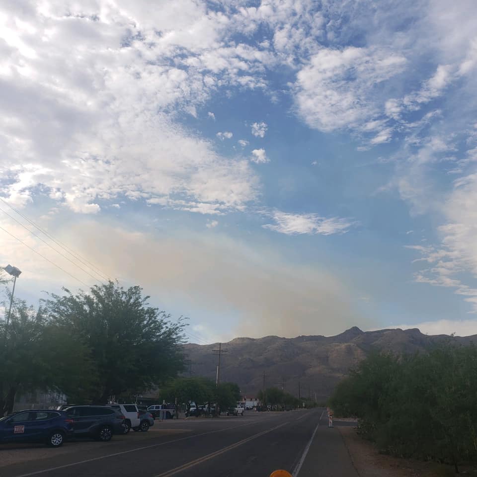
Crews Monitoring Smoke Column Over Bighorn Fire
Related Incident:
Publication Type: Announcement
Fire officials have received several questions from surrounding communities about the smoke column currently visible on the Bighorn Fire. Firefighters are aware of the rising smoke, and have checked the area. The smoke is coming from well within the interior of the fire perimeter and is reacting to outflow winds from passing storms. Crews will continue to monitor.
Online Community Meeting Announced Excessive Heat Warning Through Monday
Related Incident:
Publication Type: News
Bighorn Fire – July 11, 2020 Daily Update
Southwest Area Type 2 Incident Management Team 4
Carl Schwope, Incident Commander
Bighorn Fire Info: (520) 329-7439, 8AM-8PM
Media Phone Line: (520) 329-7640, 8AM-8PM
Website: inciweb.nwcg.gov/incident/6741/
Facebook: www.facebook.com/bighornfireinfo
Smoke: wildlandfiresmoke.net/outlooks/EasternArizona
Burned Area Response: inciweb.nwcg.gov/incident/6796/
NWS Burn Scar: www.weather.gov/twc/bighorn-burn-scar
Incident Statistics
Location: Santa Catalina Mountains
Size: 119,250 acres
Containment: 85%
Date detected: June 5, 2020
Cause: Lightning
Resources: 3 Hand Crews, 8 Engines, 1 Dozer, 1 Water-tender, 1 Helicopter, 263 Personnel
Highlights: A forest closure remains in effect for the areas surrounding the Bighorn Fire. Residents are reminded that it is illegal to enter the forest area closure.
The Pima County Sheriff’s Department has adjusted the restrictions for the Catalina Highway. All Summerhaven, Soldier Camp, and Willow Canyon residents and employees (with proper documentation) will be allowed to return without an escort. More details are available at https://www.facebook.com/pimasheriff
A virtual community meeting is being planned for Sunday, July 12 at 3:00 p.m. at https://www.facebook.com/bighornfireinfo/
An American Sign Language interpreter and CART captioning will be provided. A recording will be posted following the meeting. No account is required to view the video. If a pop-up box appears when you first navigate to the link, you can use the scroll bar on the right to scroll down to the view and/or click “not now” to minimize the login pop-up. We will monitor online Facebook questions during the meeting, or you can email us your questions in advance at 2020.bighorn@firenet.gov. This will be the last meeting hosted by the Southwest Area Incident Management Team 4.
Weather: Mostly sunny to partly cloudy, then late morning and afternoon buildups over the mountains. Isolated thunderstorms are likely in the area but should stay south and east of the fire. Minimum humidity levels will range from around 12% across the lower elevations to 18 to 28% over the higher elevations. Temperatures will range from 106-111 degrees in the valley. The Excessive Heat Warning issued for Southeast Arizona remains in place through Monday evening.
Yesterday’s Activity: Chipping operations were completed in Carter Canyon and Marshall Gulch. On the southwest corner of the Pusch Ridge Wilderness near Pima Canyon, crews disassembled a one-mile long hose lay of firehose, pumps, and water holding tanks.
Today’s Activity:
Crews will be working in the Palisades area today, utilizing a chipper to clean up debris from fireline construction. An excavator will be used in Marshall Gulch to rehabilitate fireline. In addition to working on the suppression and repair projects, firefighters are also available to assist locally with any initial attack response needed for new fire starts.
County Evacuation and Flood Information
PIMA
COCHISE
PINAL
pinalcountyaz.gov/emergencymanagement
Closures: Cascabel Road at the Cochise County/Pima County line is now open. Sabino Canyon, Bear Canyon, Redington Road and Catalina State Park are closed. Catalina Highway is closed to the public at milepost zero. Closures and maps are available at inciweb.nwcg.gov/incident/closures/6741/. A temporary flight restriction is in place over the fire area. If you fly, we can’t – knowbeforeyoufly.org.
Forest conditions available at: fs.usda.gov/alerts/coronado/alerts-notices
Bighorn Fire Video Update for July 11 2020
Related Incident:
Publication Type: Announcement
The Bighorn Fire Video Update for July 11, 2020 with Operations Section Chief Buck Wickham is now available on the Bighorn Fire Info Facebook page at https://www.facebook.com/watch/?v=279111960024772
Forest Closures Remain in Effect Catalina Hwy Closed for Nonresidents
Related Incident:
Publication Type: Announcement
Residents and recreationists are reminded that it is illegal to enter the forest area closure. https://www.fs.usda.gov/alerts/coronado/alerts-notices
The Pima County Sheriff’s Department has adjusted the restrictions for the Catalina Highway.
All Summerhaven, Soldier Camp, and Willow Canyon residents and employees (with proper documentation) will be allowed to return without an escort. The highway remains closed for non-residents.
More details are available at https://www.facebook.com/pimasheriff.
Increase in Containment Excessive Heat Warning Issued
Related Incident:
Publication Type: News
Bighorn Fire – July 10, 2020 Daily Update
Southwest Area Type 2 Incident Management Team 4
Carl Schwope, Incident Commander
Bighorn Fire Info: (520) 329-7439, 8AM-8PM
Media Phone Line: (520) 329-7640, 8AM-8PM
Website: inciweb.nwcg.gov/incident/6741/
Facebook: www.facebook.com/bighornfireinfo
Smoke: wildlandfiresmoke.net/outlooks/EasternArizona
Burned Area Response: inciweb.nwcg.gov/incident/6796/
NWS Burn Scar: www.weather.gov/twc/bighorn-burn-scar
Incident Statistics
Location: Santa Catalina Mountains
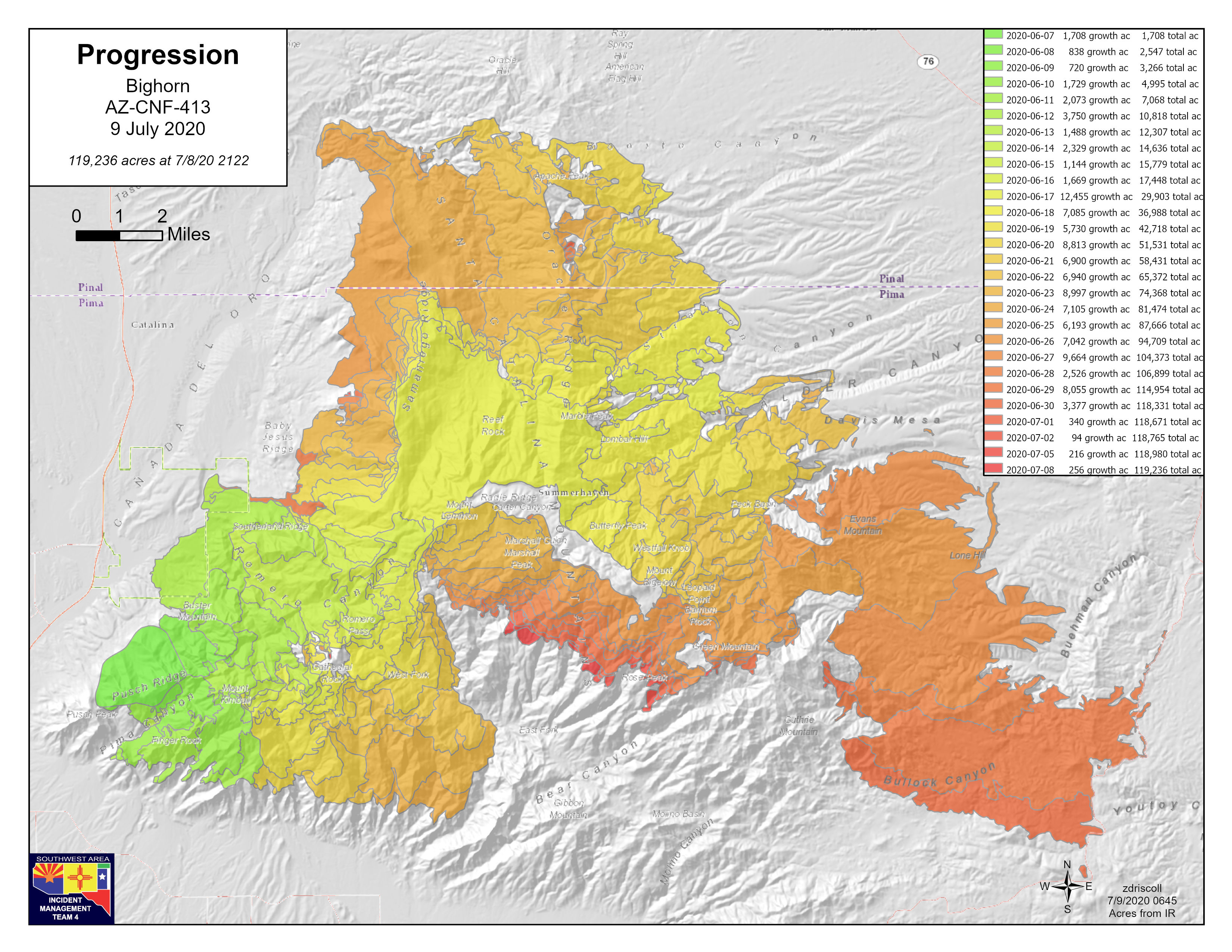
Size: 119,236 acres
Containment: 85%
Date detected: June 5, 2020
Cause: Lightning
Resources: 4 Hand Crews, 10 Engines, 2 Water-tenders, 2 Helicopters, 315 PersonnelHighlights: The Pima County Sheriff’s Department has adjusted the restrictions for the Catalina Highway. All Summerhaven, Soldier Camp, and Willow Canyon residents and employees (with proper documentation) will be allowed to return without an escort. More details are available at https://www.facebook.com/pimasheriff. Residents are reminded that it is illegal to enter the forest area closure.
Residents that have returned to Summerhaven may continue to see smoke during the day along with possible embers glowing at night. Firefighters continue to patrol around Summerhaven to ensure there is no active fire that could pose a threat to the residents in Summerhaven, Soldier Camp, and Willow Canyon. Successful firefighting efforts have resulted in increased containment up to 85%.
Weather: Mostly sunny followed by late morning and afternoon cloud buildups over the mountains. Minimum humidity levels are increasing to 15% across the lower elevations and 20 to 30% in the higher elevations. Temperatures will range from 103‑108 degrees in the valley. Hot temperatures are expected to increase into the weekend, with Sunday being the hottest day. An Excessive Heat Warning has been issued for Southeast Arizona starting Friday afternoon through Monday evening.
Yesterday’s Activity: Chipping operations began in Carter Canyon near Summerhaven to reduce brush and other vegetation material created during fireline construction. Firefighters “ground-truthed” several heat sources that were detected on the Wednesday night infrared flight. After a thorough investigation, firefighters determined that these hot spots were located safely within the containment lines and posed no threat.
A recording of last night’s Online Community Meeting is available at: https://www.facebook.com/bighornfireinfo/
Today’s Activity: Continue backhaul and removal of fire suppression materials. On the southwest corner of the Pusch Ridge Wilderness near Pima Canyon, crews will begin to disassemble a one-mile long hose lay of firehose, pumps, and water holding tanks. Rehabilitation of fireline will continue in the Marshall Gulch area. In addition to working on the suppression and repair projects, firefighters are also available to assist with any initial attack response needed for new fire starts in the area.
County Evacuation and Flood Information
PIMA
COCHISE
PINAL
pinalcountyaz.gov/emergencymanagement
A temporary flight restriction is in place over the fire area. If you fly, we can’t knowbeforeyoufly.org.
Closures: Cascabel Road at the Cochise County/Pima County line is now open. Sabino Canyon, Bear Canyon, and Catalina State Park are closed. Catalina Highway is closed to the public at milepost zero. Closures and maps are available at inciweb.nwcg.gov/incident/closures/6741/.
Forest conditions: fs.usda.gov/alerts/coronado/alerts-notices
Bighorn Fire Video Update for July 10 2020
Related Incident:
Publication Type: Announcement
The Bighorn Fire Video Update for July 10, 2020 with Operations Section Chief Buck Wickham is now available on the Bighorn Fire Info Facebook page at https://www.facebook.com/bighornfireinfo/videos/2649774378592068
Bighorn Fire Video Update for July 9 2020
Related Incident:
Publication Type: Announcement
The Bighorn Fire Video Update for July 9, 2020 with Operations Section Chief Buck Wickham is now available on the Bighorn Fire Info Facebook page at https://www.facebook.com/bighornfireinfo/videos/927294287695137
Bighorn Fire Virtual Community Meeting July 9 at 800 pm
Related Incident:
Publication Type: Announcement
Join fire managers for an online community meeting Tonight July 9, at 8:00 p.m.
An American Sign Language interpreter and captioning will be provided. A recording will be posted following the meeting. No account is required to view the video. If a pop-up box appears when you first navigate to the link, you can use the scroll bar on the right to scroll down to the view and/or click “not now” to minimize the login pop-up. https://www.facebook.com/bighornfireinfo/
We will monitor online Facebook questions during the meeting or you can e-mail us your questions in advance at 2020.bighorn@firenet.gov
We will try to answer as many questions as we can.
A recording of the informational meeting will be available on the Facebook page for later viewing.
Online Community Meeting Scheduled Tonight July 9 800 pm
Related Incident:
Publication Type: News
Southwest Area Type 2 Incident Management Team 4
Carl Schwope, Incident Commander
Bighorn Fire Info: (520) 329-7439, 8AM-8PM
Media Phone Line: (520) 329-7640, 8AM-8PM
Website: inciweb.nwcg.gov/incident/6741/
Facebook: www.facebook.com/bighornfireinfo
Smoke: wildlandfiresmoke.net/outlooks/EasternArizona
Burned Area Response: inciweb.nwcg.gov/incident/6796/
NWS Burn Scar: www.weather.gov/twc/bighorn-burn-scar
Incident Statistics
Location: Santa Catalina Mountains
Size: 119,020 acres
Containment: 79%
Date detected: June 5, 2020
Cause: Lightning
Resources: 4 Hand Crews, 11 Engines, 4 Water-tenders, 2 Helicopters, 302 Personnel
Highlights: A virtual community meeting is being planned for tonight Thursday, July 9 at 8:00 p.m. at https://www.facebook.com/bighornfireinfo/
An American Sign Language interpreter and CART captioning will be provided. A recording will be posted following the meeting. No account is required to view the video. If a pop-up box appears when you first navigate to the link, you can use the scroll bar on the right to scroll down to the view and/or click “not now” to minimize the login pop-up. We will monitor online Facebook questions during the meeting, or you can email us your questions in advance at 2020.bighorn@firenet.gov
Weather: Cumulus clouds will build over the area today, with a chance of thunderstorms near or possibly over the fire that may bring outflow winds and rain. Minimum humidity levels are increasing and will be 15% across the lower elevations and20 to 30% in the higher elevations. Temperatures will range from 102‑106 degrees in the valley.
Yesterday’s Activity: Crews completed chipping operations in Catalina State Park along with some additional trail rehabilitation projects in the park. Firefighters working in Summerhaven continued to repair and rehabilitate firelines. In addition, crews continued efforts to remove unneeded water handling equipment and backhaul over one-mile of firehose from the Summerhaven area, so it can be refurbished and placed back in the cache.
Today’s Activity: Chipping operations will be moving into the Summerhaven area to reduce brush and other vegetation material created during fireline construction. Hotshot crews working in the Summerhaven area will continue to monitor fire activity and prep along the Catalina Highway where fire is still active on the south flank of Rose Peak. Repopulation of Summerhaven continues under restrictions established by the Pima County Sheriff’s Office. More details are available at https://www.facebook.com/pimasheriff
Because of decreased fire activity, pilots had not completed an infrared flight for several days. As a result, the reported fire acreage has remained unchanged since July 6. Today’s increase in acreage reflects the fire growth over the past three days, as detected in an infrared flight conducted last night.
County Evacuation and Flood Information
PIMA
COCHISE
PINAL
pinalcountyaz.gov/emergencymanagement
A temporary flight restriction is in place over the fire area. If you fly, we can’t knowbeforeyoufly.org.
Closures: Cascabel Road at the Cochise County/Pima County line is now open. Sabino Canyon, Bear Canyon, and Catalina State Park are closed. Catalina Highway is closed to the public at milepost zero. Closures and maps are available at inciweb.nwcg.gov/incident/closures/6741/.
Forest conditions: fs.usda.gov/alerts/coronado/alerts-notices