
Bringham Fire Video Update for June 14 2020
Related Incident:
Publication Type: Announcement
Bringham Fire Video Update for June 14, 2020 with Operations Section Chief Buck Wickham is available on Facebook at
https://bit.ly/2ULcPkZ.
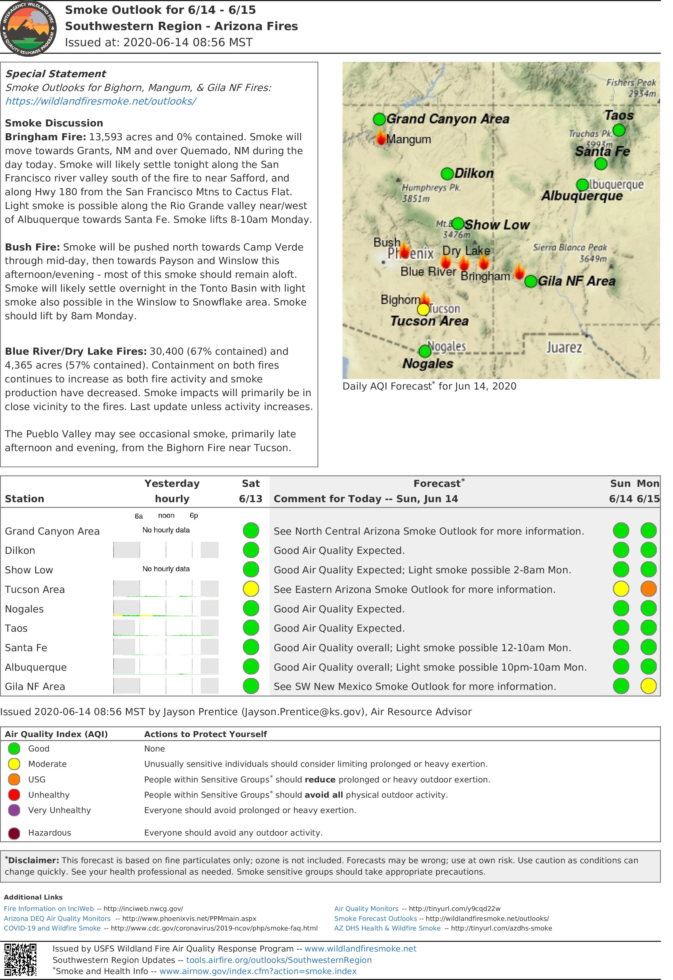
Southwest Area Smoke Outlook
Related Incident:
Publication Type: Announcement
The southwest area smoke outlook for 6/14 and 6/15 is now available at https://wildlandfiresmoke.net/outlooks/SouthwesternRegion.
Firefighters prepare to protect National Scenic Byway from Bringham Fire
Related Incident:
Publication Type: News
Building on the strategies developed by the Type 3 Team, Carl Schwope’s Type 2 Incident Management Team focused yesterday’s efforts on the protection of Highway 191. Throughout the day, firefighters prepared the eastern edge of this National Scenic Byway by manually removing vegetation with mechanical tools ahead of planned burning operations. This advanced preparation allows firefighter to moderate fire behavior and control fire movement. In those areas that were previously prepped, firefighters ignited the remaining vegetation to remove any potential fuel source in advance of the main fire. By removing flammable fuels from along the road, firefighters can better prevent flames from carrying at higher intensities toward this valuable scenic corridor. Firefighters have completed over five miles of prepwork along the roadway and will continue making progress in the days ahead.
For the protection of the public and our firefighters, Highway 191 is closed in both directions between Mile Marker 189 (just past Juan Miller Road) and Mile Marker 225 (Blue Vista). This closure will remain in place through June 21, 2020 and may be extended as firefighters continue this important work to secure the road corridor. Motorists should adjust travel plans accordingly. More information can be found at https://azdot.gov/adot-news/us-191-closed-eastern-arizona-mountains-due-bringham-fire.
The Type 2 Team has ordered additional resources to support this full suppression operation, bringing the total personnel to over 200 people. Crews are operating in small groups and dispersed into isolated camps to provide our firefighters better social distancing. The addition of these crews and fire managers has allowed the Team to increase the number of firefighters on all sides of the fire, and to provide added logistical support to meet their needs. The safety of the public and the wildland fire responders is the number one priority for this incident.
Despite the lightning, light precipitation and strong winds observed yesterday, the fire did not experience significant growth and no new fire starts were detected in the area. Afternoon thunderstorms are again predicted to impact the fire area with gusty and erratic outflow winds that may be further amplified by steep terrain in the fire area.
Fire Information Officers are available from 8:00AM to 8:00PM to respond to questions via phone at (928) 288-2154 or email at 2020.bringham@firenet.gov. Additional fire information can be found at the links below:
InciWeb: https://inciweb.nwcg.gov/incident/6747/
Facebook (updates and daily operational videos): https://www.facebook.com/apachesitgreavesnfs/
Interactive Bringham Fire Map: http://www.fs.usda.gov/goto/BringhamFireWebMap
Temporary Closure Order: https://www.fs.usda.gov/detail/asnf/alerts-notices/?cid=stelprd3793918Bringham Fire Public Information Web Map
Related Incident:
Publication Type: Announcement
Southwest Area Incident Management Team 4 has created an interactive map for the Bringham Fire. It can be viewed at
SW Area Type 2 Incident Management Team 4 Assumes Command of Bringham Fire
Related Incident:
Publication Type: News
The Southwest Area Type 2 Incident Management Team 4, led by Incident Commander Carl Schwope, assumed command of the Bringham Fire this morning, Saturday, June 13, 2020, at 6:00AM. A Type 2 Incident Management Team brings additional resources and more robust management capabilities to manage an increasingly complex fire.
Firefighters are fully suppressing the lightning-caused Bringham Fire to protect natural and cultural resources, including habitat for threatened and endangered species. Other values at risk include various structures such as the Rose Peak Lookout and campground sites along Highway 191. Firefighters will work diligently to keep the fire east of Highway 191, commonly known as the Coronado Trail.
Thunderstorms on Friday evening caused erratic winds over the fire area. Light precipitation was reported as cooler temperatures helped to moderate fire activity. An increased risk of dry lighting and gusty outflow winds up to 35 MPH will persist into Sunday. Despite the chance of rain, these thunderstorm winds may promote slope-driven fire spread north, northeast, west and southwest.
During the past 24 hours, the fire has been burning mostly toward the north from Yerba Basin and backing down the north side of Red Mountain. Today firefighters will prepare for potential burn out operations along Highway 191 to remove vegetation and prevent the main fire from reaching this important corridor. Once burnout operations begin, multiple days of burning may be needed to maintain control of the fire movement and behavior.
A temporary closure order has been issued to assure the protection of public health and safety in the Bringham Fire area. You can view the entire closure order at https://www.fs.usda.gov/detail/asnf/alerts-notices/?cid=stelprd3793918. Highway 191 is closed in both directions between Mile Marker 189 (just past Juan Miller Road) and Mile Marker 225. This closure will remain in place through June 21, 2020 and may be extended as needed. More information can be found at https://azdot.gov/adot-news/us-191-closed-eastern-arizona-mountains-due-bringham-fire.
Fire information can be found on InciWeb at https://inciweb.nwcg.gov/incident/6747/, on the Apache-Sitgreaves National Forests Facebook page at https://www.facebook.com/apachesitgreavesnfs/, and on the Forest website at www.fs.usda.gov/asnf. Fire Information Officers are available from 8:00AM to 8:00PM to respond to questions via phone at (928) 288-2154 or email at 2020.bringham@firenet.gov.
News Release Bringham Fire
Related Incident:
Publication Type: News
Location of Origin: Apache-Sitgreaves National Forests, Clifton Ranger District
Start Date: June 6, 2020
Size: Approximately 10,803 Acres
Cause: Lightning
Percent Contained: 0
Personnel: 180
Resources Assigned: 4 hotshot crews, 1 initial attack crew, 3 Type 6 engines, 1 Type 3 engine, 2 water tenders, 1 Type 1 helicopter, 1 Type 2 helicopter, 1 Type 3 helicopter, various incident management overhead.
Thunderstorm Winds Push Bringham Fire
A thunderstorm moved into the area on Thursday producing strong erratic outflow winds, pushing the head of the fire to the northwest. As the fire progressed toward a trigger point near the Rose Peak lookout facility, fire crews began burnout operations to keep the fire east of Highway 191. Fire managers worked closely with the National Weather Service office in Tucson who provided the team with real-time tracking of the thunderstorm system, which was crucial in informing on-the-ground tactical decisions.
The weather for the Bringham fire is calling for dry thunderstorms today with gusty and erratic winds up to 35 miles per hour. The Bringham Fire is burning in steep, remote, inaccessible terrain, and erratic winds continue to push the fire North, West and Southwest, and continues to threaten US 191/Coronado Trail.
Burnout operations will continue today as needed if the fire reaches established trigger points along Highway 191. Burnout operations can produce large amounts of smoke, and although these tactics are vital to successful firefighting operations, smoke from wildfires can be hazardous to your health. The Arizona Department of Environmental Quality operates a network of portable particulate monitors across Arizona so that anyone can view air quality by visiting their website at https://www.phoenixvis.net/ppmmain.aspx.
Due to the increased complexity of the Bringham fire, a Type 2 Southwest Incident Management Team will be assuming command of the Bringham Fire at 0600 on Saturday, June 13.
A temporary Closure Order has been implemented for the Bringham fire and can be accessed at https://www.fs.usda.gov/detail/asnf/alerts-notices/?cid=stelprd3793918. Highway 191 is closed in both directions between mile-marker 189 (just past Juan Miller road) and mile-marker 225. More information can be found at https://azdot.gov/adot-news/us-191-closed-eastern-arizona-mountains-due-bringham-fire.
Fire information can be found on InciWeb at https://inciweb.nwcg.gov/incident/6747/. Information about the Apache-Sitgreaves National Forests can be found at www.fs.usda.gov/asnf.
News Release Bringham Fire
Related Incident:
Publication Type: News
Location of Origin: Apache-Sitgreaves National Forests, Clifton Ranger District
Start Date: June 6, 2020
Size: Approximately 4,800 Acres
Cause: Lightning
Percent Contained: 0
Personnel: 166
Resources Assigned: 3 hotshot crews, 1 initial attack crew, 3 Type 6 engines, 1 Type 3 engines, 2 water tenders, 1 Type 1 helicopter, 1 Type 2 helicopter, 1 Type 3 helicopter, various incident management overhead.
Wildfire Movement Triggers Burnout Operations
Driven by wind and terrain, the Bringham fire reached a predetermined trigger point at Red Mountain Overlook on Wednesday. In response, firefighters conducted planned burnout operations along Highway 191 to keep the approaching fire front in check and keep the fire to the east of the highway. Values at risk that have been identified include the highway, area cabins, Rose Peak lookout, campground sites, natural and cultural resources, and threatened and endangered species and their habitat.
The Bringham fire is expected to experience isolated showers and thunderstorms today and Friday, although forecasts aren’t calling for much relief in the form of rainfall. Thunderstorms can produce gusty and erratic winds and can cause fire to spread in all directions, and fire managers are prepared for this weather event.
Burnout operations will continue today if the fire reaches established trigger points along Highway 191, and portable water tanks have been set up along the highway to support helicopter resources in this effort. Burnout operations can produce large amounts of smoke, and although these tactics are vital to successful firefighting operations, smoke from wildfires can be hazardous to your health. The Arizona Department of Environmental Quality operates a network of portable particulate monitors across Arizona so that anyone can view air quality by visiting their website at https://www.phoenixvis.net/ppmmain.aspx.
A temporary Closure Order has been implemented for the Bringham fire and includes some forest roads, trails, day-use area facilities, and one campground. The closure order document and map can be found at https://www.fs.usda.gov/detail/asnf/alerts-notices/?cid=stelprd3793918. The public is reminded that Highway 191 is closed in both directions between mile-marker 189 (just past Juan Miller road) and mile-marker 225. More information can be found at https://azdot.gov/adot-news/us-191-closed-eastern-arizona-mountains-due-bringham-fire.
Fire information can be found on InciWeb at https://inciweb.nwcg.gov/incident/6747/. Information about the Apache-Sitgreaves National Forests can be found at www.fs.usda.gov/asnf.
Temporary Area Closure
Related Incident:
Publication Type: Closures
A temporary Closure Order for the Bringham fire area went into effect on June 10, 2020. The closure includes some forest roads, trails, day-use area facilities, and one campground. The purpose of the temporary area closure is to assure the protection of public health and safety in the closure area during the Bringham Fire activities. The closure order document and map can be found at https://www.fs.usda.gov/detail/asnf/alerts-notices/?cid=stelprd3793918.
News Release Bringham Fire
Related Incident:
Publication Type: News
Location of Origin: Apache-Sitgreaves National Forests, Clifton Ranger District
Start Date: June 6, 2020
Size: Approximately 2,700 Acres
Cause: Lightning
Percent Contained: 0
Personnel: Approximately 155
Resources Assigned: 3 hotshot crews, 2 initial attack crews, 3 Type 6 engines, 2 Type 3 engines, 2 water tenders, 1 Type 1 helicopter, 1 Type 2 helicopter, 1 Type 3 helicopter, various incident management overhead.
Fire Activity Increases on Bringham Fire
The Bringham Fire is situated in steep, rugged terrain, and these factors resulted in very active fire behavior today, especially along the southwest flanks. Fire crews successfully completed structure protection at the Rose Peak lookout tower facility, and similar work continues at various cabins of which some are classified as cultural resources.
Preparation for burnout operations along Highway 191 will include the use of helicopters to keep the fire in check, based on predetermined trigger points. The highway is a crucial holding feature, or man-made barrier, that incident managers will utilize to keep the fire contained to the east. To support the planned burnout operations, crews are setting up portable water sources along Highway 191 so that helicopters and crews can have easy access to this vital firefighting resource.
A temporary Closure Order for the Bringham fire area went into effect on June 10, 2020. The closure includes some forest roads, trails, day-use area facilities, and one campground. The purpose of the temporary area closure is to assure the protection of public health and safety in the closure area during the Bringham Fire activities. The closure order document and map can be found at https://www.fs.usda.gov/detail/asnf/alerts-notices/?cid=stelprd3793918.
The public is reminded that Highway 191 is closed in both directions between mile-marker 189 (just past Juan Miller road) and mile-marker 225. ADOT signage is in place near both blockades on the highway. ADOT issued a traffic advisory yesterday for Highway 191, and more information can be found at https://azdot.gov/adot-news/us-191-closed-eastern-arizona-mountains-due-bringham-fire.
A temporary flight restriction is in place over the fire area. Wildfires are a No Drone Zone. For more information visit the Know Before You Fly website at http://knowbeforeyoufly.org.
Fire information can be found on InciWeb at https://inciweb.nwcg.gov/incident/6747/. Information about the Apache-Sitgreaves National Forests can be found at www.fs.usda.gov/asnf.
Highway 191 Closure
Related Incident:
Publication Type: Closures
Tentative burnout operations are being planned to reinforce holding features and could bring smoke and fire close to Highway 191. To ensure public safety, the highway has been closed in both directions and will remain in place through July 4, 2020. The closure is between mile-marker 186 and mile-marker 225. ADOT signage will be in place near both blockades on Highway 191. Only owners or lessees of land within the area will be exempted from the highway closure. ADOT issued a traffic advisory for Highway 191, and more information can be found at https://azdot.gov/adot-news/us-191-closed-eastern-arizona-mountains-due-bringham-fire.