
Prescribed fire planned for March 6th 2021
Related Incident:
Publication Type: Announcement
The Hoosier National Forest is planning on conducting a prescribed fire today. A map of this location can be found attached to this announcement.
Blanton - 215 acres - Orange County - Located off of County Rd 500 near the Wesley Chapel Methodist Church.
Prescribed fires planned for March 5th 2021
Related Incident:
Publication Type: Announcement
The Hoosier National Forest is planning on conducting 2 prescribed fires today. A map of these locations can be found attached to this announcement.
Bottle - 40 acres - Orange County
Johnson Schoolhouse - 134 acres - Orange County
Hoosier National Forest to conduct Prescribed Burns
Related Incident:
Publication Type: News
Hoosier National Forest to conduct prescribed burns
Bedford, Indiana. March 4, 2021 —The U.S. Forest Service has begun to conduct seasonal prescribed burns to maintain, restore or improve early successional habitat, maintain wetlands, restore unique barrens ecosystems, and regenerate oak and hickory. Prescribed burns also improve soil health by recycling nutrients and reduce fuel loads, thereby lowering the risk of catastrophic wildfire.Approximately 5-6,000 acres are planned to receive prescribed burning in the spring of 2021 on National Forest System lands in the following counties: Brown, Crawford, Jackson, Martin, Monroe, Orange, and Perry.U.S. Forest Service fire managers utilize National Weather Service data to determine the best days to burn to achieve desired goals and to maximize safety. Many specific conditions must be met for a burn to occur, including fuel moisture, wind speed and direction, and relative humidity, among other factors. Decisions are generally made the day of the burn once parameters have been measured or forecasted. Therefore, advance specific notification for a particular burn can be difficult. Forest staff notifies the public in the immediate area of the prescribed burn. The public is advised to check the forest’s social media accounts for announcements of burns at www.facebook.com/HoosierNF/ and https://twitter.com/HoosierNF. Maps and additional details of the burn areas will be available at the following website: https://inciweb.nwcg.gov.All designated burn areas will not be accessible to the public on the day of the burn and for some time after the burn until the area is considered safe. If any hazards are identified within the burn area, the area may be inaccessible for several days for public safety. Burning may affect access to hunting areas. For your safety, please contact the Indiana Interagency Coordination Center dispatch (812-547-9262) if you plan to hunt or camp in or near prescribed burn areas.An unfortunate side effect of prescribed burning is smoke. Fire managers burn only under atmospheric conditions specified in a burn plan and rely on scientific data to choose days in which the impacts of smoke are minimized. Smoke plumes from a prescribed fire usually rise high into the air where the smoke dissipates. When smoke is present, motorists should reduce speeds and turn on headlights.All burns are done under carefully planned prescriptions and protocols to mitigate the risk of an escaped fire and smoke exposure to communities. All planned activities have been carefully coordinated with county emergency management agencies. Forest neighbors who wish to benotified of a specific date of a burn, or those who wish to report medical conditions that could be affected by smoke, may contact the Indiana Interagency Coordination Center Dispatcher at 812-547-9262.USDA is an equal opportunity provider, employer, and lender.
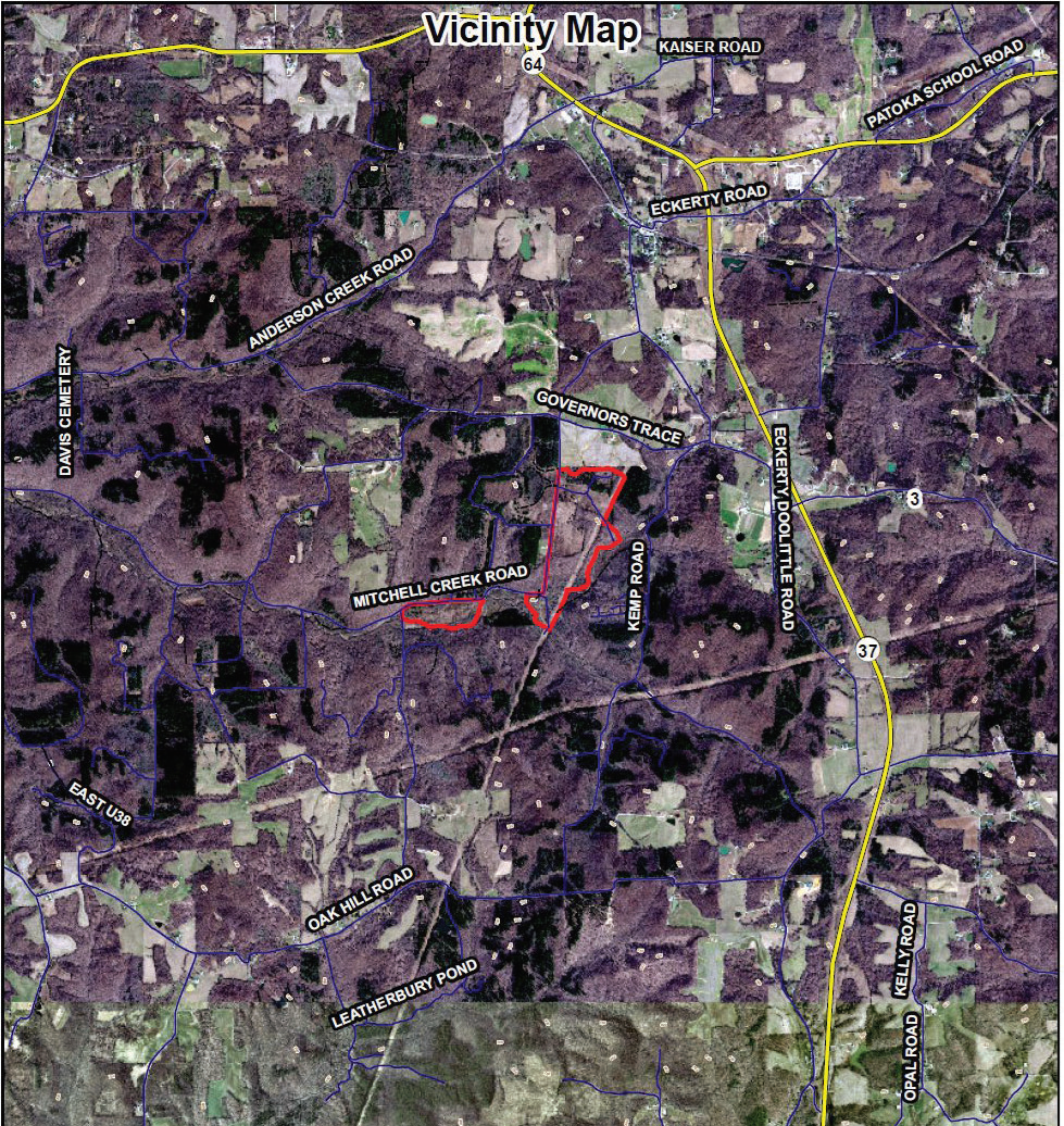
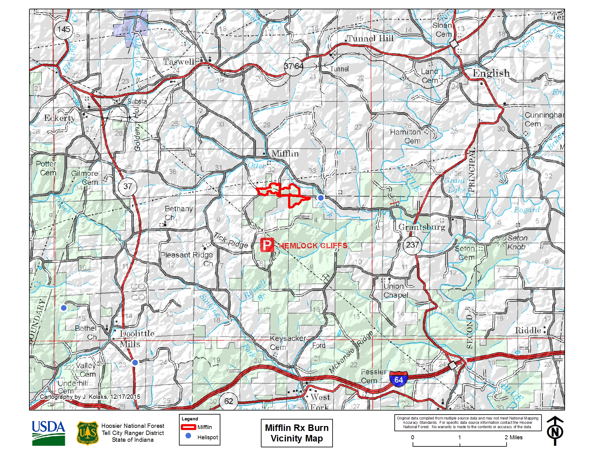
Prescribed fire planned for March 4th 2021
Related Incident:
Publication Type: Announcement
The Hoosier National Forest is planning on conducting a prescribed fire today. A map of this location can be found attached to this announcement.
Mifflin - 46 acres - Crawford County - North of Hemlock Cliffs, off Old Felker Road near Mifflin.
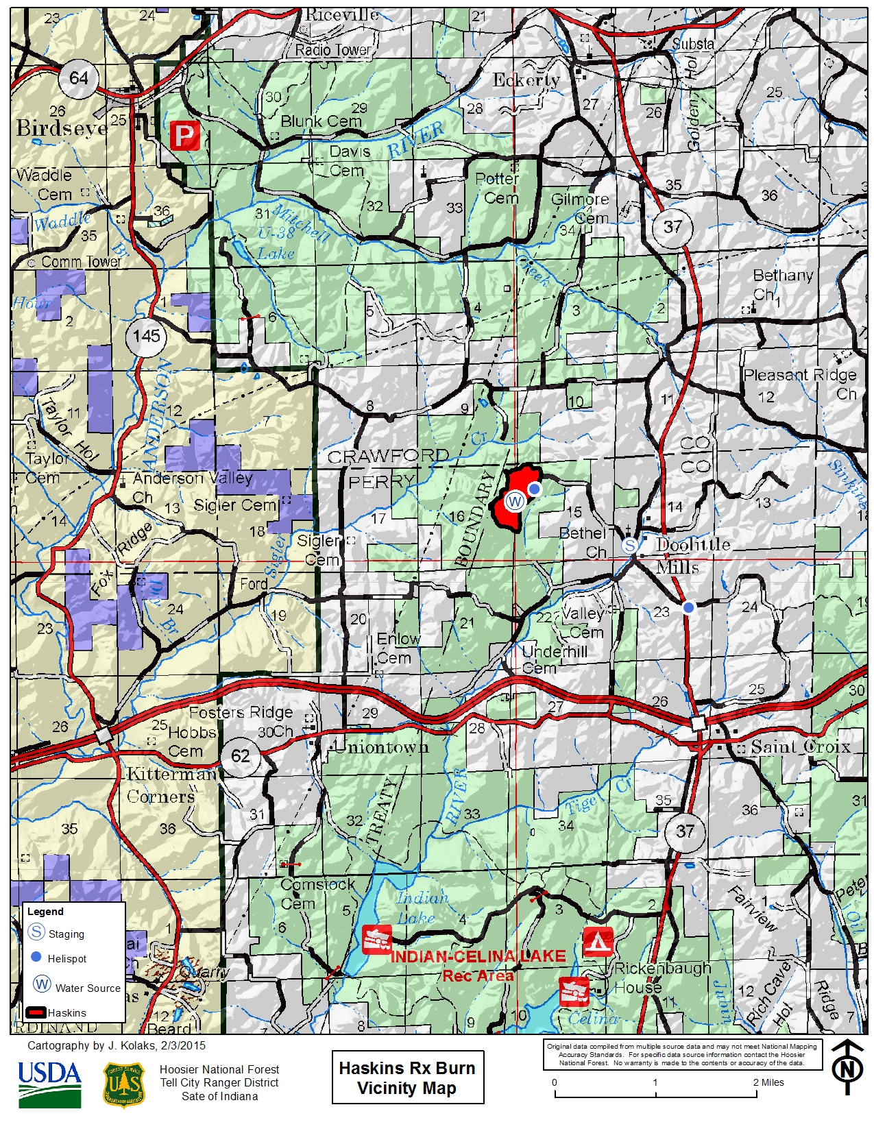
Prescribed fire planned for March 3rd 2021
Related Incident:
Publication Type: Announcement
The Hoosier National Forest is planning on conducting a prescribed fire today. A map of this location can be found attached to this announcement.
Haskins - 113 acres - Perry County, just south of Crawford County line. Located west of Doolittle Mills.
Cave Fire Update November 27 2019
Related Incident:
Publication Type: News
Cave Fire Update
November 27, 2019 9:30 a.m.
Cause: Unknown
Size: 4,330 acres
Containment: 20%
Personnel: 886
Injuries: 0
.
Road Closure and Evacuations: Hwy 154 remains closed. An update from the Santa Barbara County Sheriff’s office is expected today regarding road closures and evacuation areas. Visit www.ReadySBC.org for more information.
Current Fire Restrictions: The Los Padres National Forest currently does not allow open fires, wood or charcoal fires are prohibited in all areas of the forest, to include developed campgrounds. Additional Details are available on the Alerts and Notices page of the Los Padres National Forest Website.
Cave Fire Update November 26 2019
Related Incident:
Publication Type: News
Information Sources: A fire information call center is staffed and available to answer your questions. The phone number is 833-688-5551. Register at www.ReadySBC.org to receive emergency alerts from Santa Barbara County. Also take note of the official social media links at the top of this page. Residents need to prepare to follow directions from emergency management officials.
Road Closure: A soft closure is in place at the 246/154 for residents. A hard closure is in place on Highway 154 at Paradise Road.
Drones: Drones pose a serious risk to firefighting and can cause air operations to cease. The public is reminded that “If you fly, we can’t!”
Current Fire Restrictions: The Los Padres National Forest currently does not allow open fires, campfires or charcoal fires outside of developed recreation sites or designated Campfire Use Sites even with a valid California Campfire Permit. Additional Details are available on the Alerts and Notices page of the Los Padres National Forest Website.
Highway 154 Closure
Related Incident:
Publication Type: Closures
The California Highway Patrol closed Highway 154 in both directions between Highway 246 in the Santa Ynez Valley and Highway 192/Foothill Road in the Santa Barbara area.
Mississippi Woman Found Alive and in Stable Condition
Related Incident:
Publication Type: News
SEQUOIA AND KINGS CANYON NATIONAL PARKS, Calif. October 28, 2019 – Mary Joanna Gomez from Mississippi was found alive and in stable condition by National Park Service personnel on the afternoon of October 28th and has been in contact with her family and will be reunited with them shortly. She was found off trail about 3.5 miles over rocky and steep terrain from her vehicle.
A California Air National Guard aircraft C-130 first located an SOS spelled out with rocks on the ground and later identified a person nearby. Ground searchers responded and were able to find Mrs. Gomez cold, thirsty and hungry, but in otherwise good health.
Mrs. Gomez was reported missing by her family after missing her work shift in the Bay Area on Friday, October 25th. Her last contact with family had been the day prior while visiting Kings Canyon National Park, when she stated her intention to visit Sequoia. Her vehicle was located on the night of October 26th which helped narrow down the search zone.
For trip planning help and current conditions, visit our website www.nps.gov/seki.
Search Continues for Missing Mississippi Woman in Sequoia and Kings Canyon
Related Incident:
Publication Type: News
SEQUOIA AND KINGS CANYON NATIONAL PARKS, Calif. October 28, 2019 – The search for missing Mary Joanna Gomez, 56-year-old from Mississippi, continues with growing search teams and limited clues. Mrs. Gomez has been on assignment in the Bay Area as a traveling nurse, and arrived in Kings Canyon National Park on Wednesday, October 23rd on her day off. Her last communication with family was on October 24th when she text messaged her daughter with photos taken in different areas of Kings Canyon. She was expected back to work on October 25th, missed her shift, and her family reported her missing to the San Francisco Police Department.
National Park Service (NPS) staff place her in the Giant Forest of Sequoia National Park on the morning of Saturday, October 26th. That night, shortly before midnight, her vehicle was located along the Generals Highway near a trailhead by a park ranger. It had not been at that trailhead earlier in the day.
Multiple teams are actively searching the area surrounding her vehicle with search dogs, air craft and search teams on foot. Her husband and daughter arrived in Kings Canyon on Sunday, October 27th and are with NPS staff.
The investigation continues and all updates will be posted to the Inciweb site as it becomes available: https://inciweb.nwcg.gov/incident/6655/.
If you have been in the parks since Wednesday, October 23rd, specifically in the Little Baldy area, and you think you may have seen Mrs. Gomez or her vehicle, please call the tip line at 888-677-2746.
-NPS-
About Sequoia and Kings Canyon National Parks
These two parks, which lie-side-by-side in the southern Sierra Nevada in Central California, serve as a prime example of nature’s size, beauty, and diversity. Over 2 million visitors from across the U.S. and the world visit these parks for the world’s largest trees (by volume), grand mountains, rugged foothills, deep canyons, vast caverns, the highest point in the lower 48 states, and more. Learn more at http://www.nps.gov/seki or 559-565-3341.
-###-