
Miller Fire Update July10 2019
Related Incident:
Publication Type: News
Miller Fire Update July 10, 2019
Acres: 5,772
Start Date: June 29, 2019
Cause: Lightning
Location: Peloncillo Mtns. N.M.
Total Personnel: 297
Fuels: Timber, brush, and grass
Fire Activity: Recent rains have significantly decreased activity within the fire’s perimeter. Hot spots are still located within the interior, but no heat has been detected along the perimeter’s edge.
Operations: This week, crews have been utilizing an Unmanned Aircraft System (UAS). UAS has the capability to map fire progression, identify heat with infrared technology, and is utilized in conjunction with fire Air Operations to search for spot fires to reduce firefighter and aircraft exposure to smoke and hazardous terrain. Additionally, if there is a spot fire detected, the UAS can pinpoint an exact location so that firefighters can respond directly to the area of concern with appropriate resources more quickly. Firefighters are embracing this new technology and using it to their advantage. UAS Operators go through extensive and specific operating and safety courses.
These specific capabilities of a UAS, the training and safety guidelines required for pilots, are what set UAS use apart from recreational drone use in wildfire areas. Unauthorized drone incursions over the fire area are very dangerous and cause all air operations to stop, potentially putting firefighters in extreme danger.
Firefighters and Resource Advisors are working together to perform suppression repair activities in order to return the forest to a more natural state. Fire Managers have achieved 85% of our intended objectives on this incident. For more information on managing fires with multiple objective strategies please see these links.
https://biturl.org/MillerFireMultipleStrategies
https://biturl.org/MillerFireMultipleObjectives
Weather: It will be noticeably hotter today with highs in the 90’s across the fire area with minimum humidity levels dropping into the 10 to 15 percent range. Winds will be changing direction, coming from the north and northeast. They are expected to remain fairly light except for a few afternoon gusts due to the strong afternoon heating.
Closures: The temporary flight restriction closure over the fire is still in place. Crews will continue to be working in the area the next few days so please use caution on roads around the fire to protect your own welfare and that of the fire crews.
Facebook: https://www.facebook.com/CoronadoNF/
NM Fire Information: https://nmfireinfo.com/
Miller Fire Update July 9 2019
Related Incident:
Publication Type: News
Miller Fire Update July 9, 2019
Acres: 5,772
Start Date: June 29, 2019
Cause: Lightning
Total personnel: 325
Location: Peloncillo Mtns N.M.
Fuels: Timber, brush, and grass
Objectives: Objectives for this lightning-caused fire include firefighter and public safety, protecting values at risk, and managing the fire for resource benefit. Efforts have already begun to repair areas affected by firefighting operations. This effort will include dispersing excess vegetation and cutting and stacking larger woody material. Water bars will also be installed on several handlines cut on the eastern side of the fire. All of which will improve range, wildlife habitat, and watershed conditions. For more information on managing fires with multiple objective strategies and objectives please see these links.
https://biturl.org/MillerFireMultipleStrategies
https://biturl.org/MillerFireMultipleObjectives
Fire Activity: Fire activity has decreased significantly over the fire due to recent rains. Hot spots are still located within the interior; however, no heat has been detected along the perimeter edge. Warmer weather and low humidity over the next few days may challenge the security of the fire perimeter.
Operations: Firefighters remain diligent and ready to take action in the unlikely event the fire moves from its current position. On Sunday, a lighting strike started a small fire in the Animas Valley. This fire was quickly mitigated by New Mexico State Forestry crews with assistance from crews working the Miller Fire. Yesterday, crews were assisted by an Unmanned Aerial System (UAS) staffed by fire personnel in a coordinated effort with fire management to search for additional new starts from lightning strikes, remaining hot spots, and mapping the fire perimeter.
Today, fire crews will continue to monitor and evaluate the burn area. In addition, personnel will begin suppression repair activities on areas affected. As these tasks are completed, crews will begin the process of demobilization and become available in the region to assist with future incidents.
Weather: Another sunny and very warm day is expected with a light westerly breeze and temperatures climbing into the lower 90’s across much of the fire area. The air will remain dry with rather poor overnight humidity recovery followed by a low relative humidity in the afternoon.
Closures: There is a temporary flight restriction closure over the fire. No other closures are in the area however, crews will still be working over the next several days. Please use caution on roads around the fire to protect your own welfare and that of the fire crews.
Facebook: https://www.facebook.com/CoronadoNF/
NM Fire Information: https://nmfireinfo.com/Managing the Miller Fire with Multiple Strategies
Related Incident:
Publication Type: News
Fact Sheet
Managing the Miller Fire with Multiple Strategies
Wildland fires have traditionally been managed under one strategy, which usually was full suppression. This strategy implies that a fire will be “put out” as efficiently and effectively as possible while providing for both firefighter and public safety. The measure of success in a full suppression strategy is that a fireline has been completed around the perimeter of a fire to halt fire spread.
But, there are other strategies used to manage wildland fires. Those strategies include:
-
Monitor: This is the strategy of observing activity including fire behavior and fire and smoke effects. It may be done from nearby or farther away depending on fire behavior and intensity, or from aerial observation.
-
Confine: This strategy restricts a wildfire to a defined area using a combination of natural barriers and constructed fireline or other fire suppression activities to stop fire spread beyond the defined area.
-
Point or Zone Protection: This strategy protects points or zones from active fire while not attempting to suppress fire along the entire perimeter. Points or zones being protected may include, but are not limited to, homes, communication sites, communities, range improvements, cultural sites, and other areas with high resource values.
Sometimes a wildfire is managed under a strategy other than full suppression. For example, a fire burning within a remote wilderness area, where there is little or no risk to persons or structures, might be managed under a monitor strategy. At other times, a fire might be managed under two or more strategies that may or may not include full suppression.
An example of multiple strategies for wildland fire management is the Miller Fire, where 80 percent of the fire is being confined, 20 percent is under point or zone protection, and none of the fire is under full suppression.
There are different reasons for using multiple strategies. For example on part of a fire, a full suppression strategy might not be used due to rugged, inaccessible terrain where firefighter safety could not be maintained due to lack of safety zones or escape routes from the fire. Or, it might not be used where firefighters could not work effectively due to difficult terrain or lack of access. In this case, a monitor strategy might be used for this portion of the fire until the fire moved to an area where firefighters could safely and effectively suppress the fire. Naturally-ignited fires burning in areas with low values at risk may be managed to resume fire’s natural role in ecosystems, removing excess vegetation and improving range and wildlife habitat and watershed conditions.
So, how do we measure progress in managing a wildfire under multiple strategies? In a single full suppression strategy, it is easy as we simply measure the percentage of the fire perimeter, which has been suppressed or “contained.” Progress is reported as a percentage of containment.
This method doesn’t work well, however, when there are two or more strategies being used to manage a wildfire. It doesn’t work at all when full suppression is not a strategy being used to manage the fire. In those cases, we measure the amount of work that has been done to complete the various management strategies being used. Progress is reported as a percentage of completion. The Miller Fire is currently at 75 percent completion.Managing the Miller Fire for Multiple Objectives
Related Incident:
Publication Type: News
Fact Sheet
Managing the Miller Fire for Firefighter and Public Safety, and for Resource Benefits
At the beginning of the 20th century, land managers were already debating the role of wildfires in the American West. Some thought fires were a natural part of forest and rangeland ecosystems that should be allowed to burn in order to maintain forest and rangeland health. Others thought that uncontained fires represented too great a threat to timberland, rangeland, and people and they should not be allowed to burn.
In 1910, the “Big Burn” occurred in Northern Idaho and Western Montana. The fire burned 4,687 square miles and caused 87 fatalities including firefighters. The years following the Big Burn defined the ideology of wildfire management, which was full suppression. The policy was to contain wildfires to the smallest size possible as soon as possible, and for over a century land managers were very successful at doing so.
Prior to full suppression, naturally reoccurring wildfires burned through forests and rangelands. The fires were of low intensity since repeated fires kept brush, leaves, and dead logs and branches from accumulating on the ground. The fires also prevented forest overgrowth. This maintained more space between trees making them less susceptible to fire spread. As fires were excluded from the landscape, however, woody fuel on the ground accumulated and overgrowth occurred. Wildfires began to burn with more intensity, were more resistant to control, and became larger as a result. These larger, more intense fires are an increasing threat to both firefighter and public safety, forest and rangeland, personal property, and other values at risk.
While there is still a role for full suppression in wildfire management, such as the wildland-urban interface, it is not the only strategy available to land managers. Other strategies, such as confinement, monitoring, and point or zone protection, offer additional tools for achieving objectives in wildfire management.
On the Miller Fire, for example, over a century of fire suppression has allowed woody fuels such as brush, juniper, and chaparral to expand into grassland areas previously kept open by wildfires. This increases the risk of future high intensity fires, as well as changes in the natural habitat. Fully suppressing the fire would only contribute to the problem.
For that reason, the fire is being managed under two strategies where 80 percent of the fire is being confined, 20 percent is under point or zone protection, and none is under full suppression. These strategies will allow the fire to spread and to clear out woody overgrowth while protecting structures, people, and values at risk. The benefits of this combination of strategies will not only reduce the risk of future high intensity fires, but will also improve rangeland and forest health.
The strategies also provide for firefighter safety. By monitoring areas of the fire in steep, rugged inaccessible terrain, firefighters are not put at risk trying to suppress the fire where they do not have escape routes or safety zones, and cannot be evacuated quickly to medical care in case of an injury.
Miller Fire Update July 8 2019
Related Incident:
Publication Type: News
Miller Fire Update July 8, 2019
Acres: 5,772
Start Date: June 29, 2019
Cause: Lightning
Total personnel: 322
Location: Peloncillo Mtns N.M.
Fuels: Timber, brush, and grass
Fire Activity: Fire activity has lessened significantly over the fire due to recent rains. Today, the fire activity in finer, grassy fuels is expected to increase as they dry out due to hotter and drier weather moving into the area. This weather pattern will continue for the next two days.
Objectives: Objectives for this lightning-caused fire include firefighter and public safety, point protection for structures in the area, and managing the fire to perform its natural role on the landscape of clearing excess vegetation, which will improve range, wildlife habitat, and watershed conditions. Our operational strategies are supporting these objectives with the actions taken on the fire ground.
Operations: Yesterday, Miller Fire personnel assisted New Mexico State Forestry with initial attack on a lightning-caused fire in the Animas River Valley.
Today, an Unmanned Aerial System (UAS) will be used to map the fire’s perimeter, look for hot spots, and patrol for additional new starts from recent lightning.
Fire crews will continue to monitor the fire and are prepared for burnout operations on the upper side of the fire if indicated by today’s fuel and weather conditions. The low-intensity fire will create a buffer zone between the main fire and control lines, and achieve desired resource benefits. Smoke production can be heavy from burnout operations. Smoke will generally move in a north or northeast direction with predicted winds. Smoke and air quality information can be found at https://tinyurl.com/MillerFireAirQuaility.
Weather: Today will be sunny, warm and dry with a southwest to west 12-16 mph wind in the afternoon. Gusts up to 30 mph are expected with temperatures peaking around 90 degrees. The much drier air will result in afternoon minimum humidity levels approaching 10 percent followed by somewhat poor overnight recoveries.
Closures: There is a temporary flight restriction closure over the fire area. Citizens are encouraged to stay safely clear of fire area. The Geronimo Trail Road will close without notice due to fire activity and firefighters performing burnout operations. Check the links below for the most current conditions.
Facebook: https://www.facebook.com/CoronadoNF/
NM Fire Information: https://nmfireinfo.com/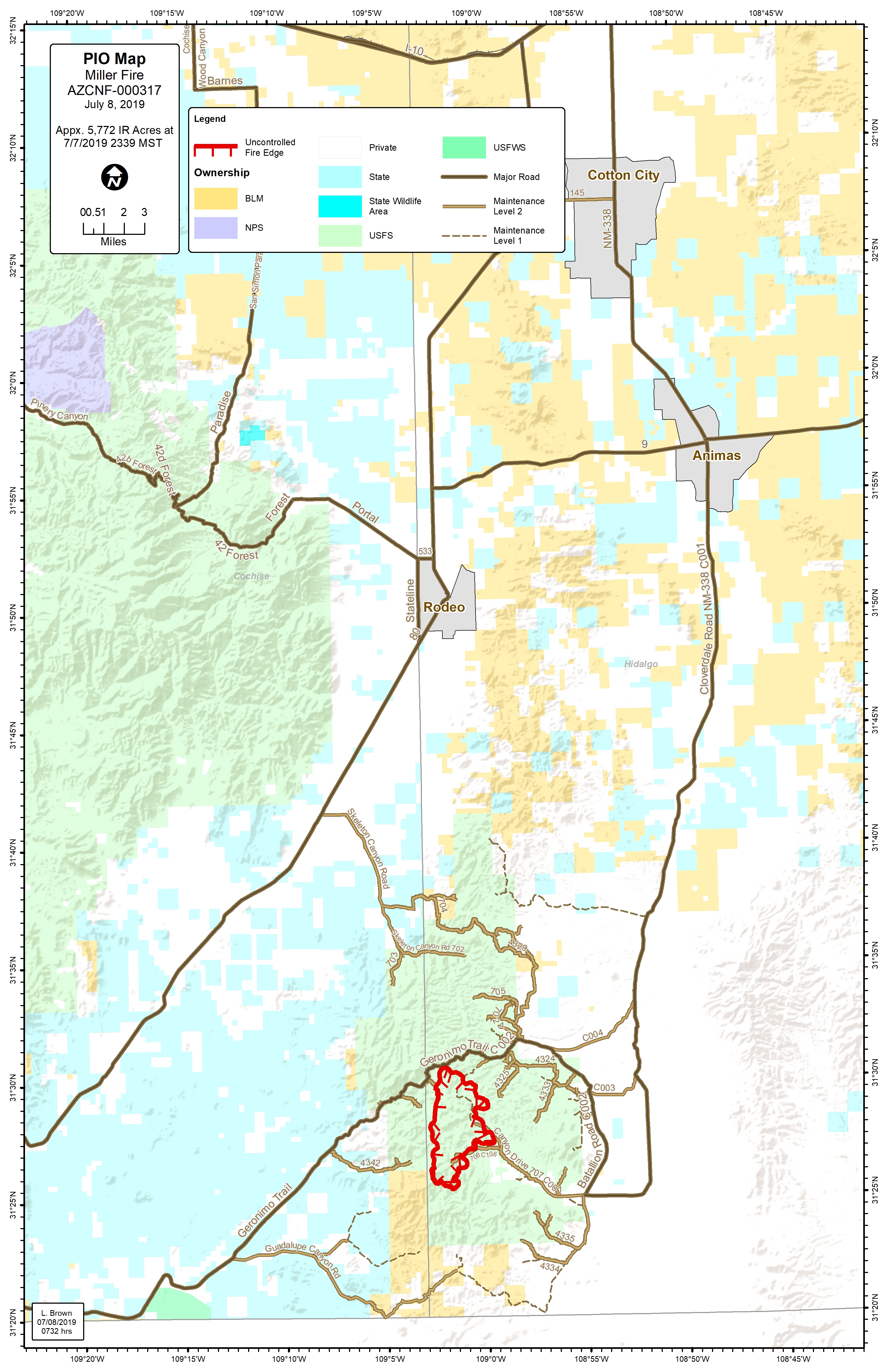
Miller Fire Update July 7 2019
Related Incident:
Publication Type: News
Acres: 5,772
Start Date: June 29, 2019
Cause: Lightning
Total personnel: 336
Location: Peloncillo Mtns N.M.
Fuels: Timber, brush, and grass
Meeting Information: The Miller Fire public meeting was held last night at the Rodeo Community Center. We thank those who attended from surrounding communities. Video excerpts of the meeting will be posted to the Coronado National Forest Facebook page https://biturl.org/MillerPublicMeeting.
Fire Activity: In spite of recent rains, heat and hotspots are occurring throughout the fire perimeter. Fire activity in finer, grassy fuels is expected to increase as they dry out due to hotter, drier weather. This weather pattern will continue into the week. Fire activity may also increase in brushy, woody fuels.
Objectives: Objectives for this lightning-caused fire include firefighter and public safety, point protection for structures in the area, and managing the fire to perform its natural role on the landscape of clearing excess vegetation, which will improve range and wildlife habitat and watershed conditions. Our operational strategies are supporting these objectives with the actions taken on the fire ground.
Operations: Work on the Geronimo Trail Road, spur roads, and hand line has been completed in preparation for burnout operations on the upper side of the fire. The burnout may start today if weather and burning conditions permit. This will create a buffer zone between the main fire and control lines.
Smoke production can be moderate to heavy with planned burnout operations. Generally smoke will move in a north or northeast direction with predicted winds, but can move in other directions depending on specific weather conditions during the week. Smoke and air quality information can be found at https://tinyurl.com/MillerFireAirQuaility.
Weather: There is a slight chance for thunderstorms today before drier air moves into the region with gusty southwest winds later in the afternoon. Those winds will peak at 12 to 17 mph with gusts around 25 mph from the mid-afternoon hours into the early evening. Temperatures will top out in the upper 80s with the humidity dipping into the upper 20s later in the day.
Closures: There is a temporary flight restriction closure over the fire area. Citizens are encouraged to stay safely clear of fire area. The Geronimo Trail Road will close without notice due to fire activity and firefighters performing burnout operations. Check the links below for the most current conditions.
Inciweb: https://inciweb.nwcg.gov/incident/6417/
Facebook: https://www.facebook.com/CoronadoNF/
NM Fire Information: https://nmfireinfo.com/
Miller Fire Update July 6 2019
Related Incident:
Publication Type: News
Acres: 5,772
Start Date: June 29, 2019
Cause: Lightning
Total personnel: 247
Location: Peloncillo Mtns N. M.
Fuels: Timber, brush, and grass
Miller Fire Public Meeting Tonight
Meeting Information: Tonight’s community meeting will be held at the Rodeo Community Center at 16 Hickory St., Rodeo, New Mexico, 88056 at 5:00 MST/6:00 MDT. The meeting, as well as daily operational briefing videos, will be recorded and posted to the Coronado National Forest Facebook page.
Fire Activity: Precipitation from Friday’s storm has hindered fire activity. This has allowed firefighters to get ahead of the fire spread prior to next weeks predicted hotter, drier weather and increased fire behavior.
Objectives: 100% containment is not the goal on the Miller Fire. The objectives are to build a control line around three sides of the fire to prevent further spread, allow the fire to burn south to improve forest health, and for firefighters to actively take structure protection measures around the ranches and properties adjacent to the fire.
Operations: Control line preparation work continues today on the northern half of the fire, as well as outside the perimeter of the Bunk Robinson Wilderness Study Area. Two engines and three helicopters are dedicated to initial attack for any new fires that may arise from the lightning predicted over the next few days. Structure protection plans are being developed for values at risk south of the fire.
Weather: Clouds increasing during the afternoon with a chance for a few showers and thunderstorms again, during the afternoon and evening hours. There is potential for strong outflow winds and dry lightning with the strongest storms. Highs will be in the 80s with an afternoon minimum humidity between 25 to 30 percent. Outside of thunderstorm influences, the general winds will be light out of a south to southwest direction.
Closures: There is a temporary flight restriction closure over the fire area. Citizens are encouraged to stay safely clear of fire area. The Geronimo Trail Road is currently open, but will close without notice due to fire activity and firefighters working off of the road.
Miller Fire Update July 5 2019
Related Incident:
Publication Type: News
Miller Fire Update July 5, 2019
Acres: 5,723
Start Date: June 29, 2019
Cause: Lightning
Containment: 0%
Total personnel: 275
Location: Peloncillo Mtns N. M.
Fuels: Timber, brush, and grass
Rodeo Community Meeting Saturday
Meeting Information: On July 6th, there will be a community meeting held at the Rodeo Community Center at 16 Hickory St., Rodeo, New Mexico, 88056 at 5:00 MST/6:00 MDT. The meeting, as well as daily operational briefing videos, will be recorded and posted to the Coronado National Forest Facebook page.
Fire Activity: There was minimal activity yesterday on the Miller Fire. It is still burning with low to moderate intensity in a mosaic pattern through the Bunk Robinson wilderness study area. While fire activity is expected to remain moderated, strong winds associated with thunderstorms could produce rapid fire spread. Currently, smoke is dissipating within a few miles of the incident, but there may be an increase in smoke production with next weeks predicted weather.
Operations: Helicopters are dropping water on the fire perimeter in areas wherever excessive heat production is not beneficial to forest health and to slow fire progression. Crews constructed three miles of handline east of the Bunk Robinson Wilderness Study Area boundary. Control line preparation work on the Geronimo Trail Road has been completed, but work continues today on spur roads. Two engines and three helicopters will be dedicated to initial attack on any new fires due to forecasted lightning over the next few days. Firefighters may need to conduct burnout operations if the main fire approaches portions of the control lines. With ranches, cultural sites, and other values in the area outside of the fire perimeter, firefighters are taking actions to protect these areas of concern should the fire move to threaten them.
Weather: Mostly cloudy today with a chance for a few showers and thunderstorms mainly during the afternoon and evening hours. There is potential for strong outflow winds and dry lightning with the strongest storms. Highs will be in the lower 80s with an afternoon minimum humidity between 25 to 30 percent. Outside of thunderstorm influences, the general winds will be light out of the southwest.
Closures: There is a temporary flight restriction closure over the fire area. Citizens are encouraged to stay safely clear of fire area. The Geronimo Trail Road is currently open, but will close without notice due to fire activity and firefighters working off of the road. Check the Inciweb page below for updates.Rodeo Community Meeting Saturday July 6th
Related Incident:
Publication Type: Announcement
There will be a community meeting on Saturday, July 6th at the Rodeo Community Center, 16 Hickory St. Rodeo, NM. The meeting will start at 6:00 p.m. New Mexico time, 5:00 p.m. Arizona time. Information will be provided and questions answered about the Miller Fire.
Miller Fire Update July 4 2019
Related Incident:
Publication Type: News
Miller Fire Update July 4, 2019
Acres: 5,723
Start Date: June 29, 2019
Cause: Lightning
Containment: 0%
Total personnel: 151
Location: Peloncillo Mtns N. M.
Fuels: Timber, brush, and grass
Summary:
On June 29th, a lightning storm in the Peloncillo Mountains is believed to have started the Miller Fire within rough, remote country in the Bunk Robinson Wilderness Study Area. The Type 2 Southwest Area Incident Management Team 4, led by Incident Commander Carl Schwope, took over management duties of the fire this morning on the Douglas Ranger District of the Coronado National Forest. Firefighters are “spiked out” in multiple smaller fire camps surrounding the fire. The team was brought in to provide logistical, communication, and operational support for the firefighters on the fireline and communities most impacted with a primary objective of firefighter and public safety.
Fire Activity: The lightning caused Miller Fire is burning with low to moderate intensity in a mosaic pattern through the wilderness study area. The fire is currently burning in a remote uninhabited area. The current conditions allow natural fire to reduce fuel loads by decreasing woody species encroachment, such as oak, juniper, and manzanita, to increase herbaceous species production and enhance wildlife habitat.
Operations: There are ranches, cultural sites, and other values in the area outside of the current fire perimeter. Firefighters are taking actions to protect these areas of concern if the fire were to threaten them. Firefighters are actively working to improve the Geronimo Trail Road and other infrastructure to be utilized as fire control lines. Firefighters are scouting out options to construct fire control lines on the fire’s eastern side while minimizing impact to the roadless area and grazing allotments.
Weather: Today will be cloudy with a few afternoon cumulus clouds. High temperatures will peak in the middle 80s after a morning low near 65 degrees with afternoon minimum humidity levels bottoming out in the middle teens. A westerly breeze of 10 to 20 mph will develop in the afternoon with gusts of 20 to 25 mph.
Closures: There is a temporary flight restriction closure over the fire area. Citizens are encouraged to stay safely clear of fire area. The Geronimo Trail Road is currently open, but will close without notice due to fire activity and firefighters working off of the road. Check the Inciweb page below for updates.