
Dolores Ranger District May 6 2019
Related Incident:
Publication Type: News
The Dolores Ranger District will be burning May 6-7, 2019. South Carver Burn Units 2 & 9 for 544 total acres.
Dolores Ranger District South Carver Units 6 and 8
Related Incident:
Publication Type: News
The Dolores Ranger District is planning a prescribed burn for the South Carver Units 6 and 8. Sunday 4/28/2019 weather permitting.
Prescribed fire scheduled in Chimney Rock National Monument
Related Incident:
Publication Type: News
PAGOSA SPRINGS, Colo., April 16, 2019 – Fire officials on the Pagosa Ranger District in San Juan National Forest will conduct prescribed fire operations in Chimney Rock National Monument as early as April 22, 2019. Less than 100 acres across three burn units are planned. Actual ignition days will depend on weather and fuel conditions, and is expected to continue over multiple days.
This effort is part of a larger hazardous fuels reduction project inside the Monument that involved both mechanical treatment and prescribed fire. Some of the over story vegetation was thinned, piled, and burned in 2009 – 2010, followed by an understory burn operation from 2011 – 2014. Vegetation consists of ponderosa pine, Gambel oak, grass and pinyon/juniper.
Prescribed fire operations will be conducted by Forest Service personnel, assisted by fire resources from cooperating agencies. The purpose is to reduce hazardous ground fuels, reduce the risk of unplanned large scale wildfires, restore ponderosa pine ecosystems and improve wildlife habitat.
Smoke will be visible from U.S. Highway 160 and Colorado Highway 151. Prescribed fires will only be ignited when all weather, fuels and smoke requirements are met. For additional information, please contact Fred Ellis, Assistant Fire Management Officer (Fuels), Pagosa Ranger District (970) 264-1541.
Current information and maps of prescribed fire units in the San Juan National Forest can be found on Inciweb: https://inciweb.nwcg.gov/incident/6288/
Prescribed fire smoke may affect your health. For more information, please go to:
https://www.colorado.gov/pacific/cdphe/wood-smoke-and-health
Plan for prescribed burning in Dolores Ranger District
Related Incident:
Publication Type: News
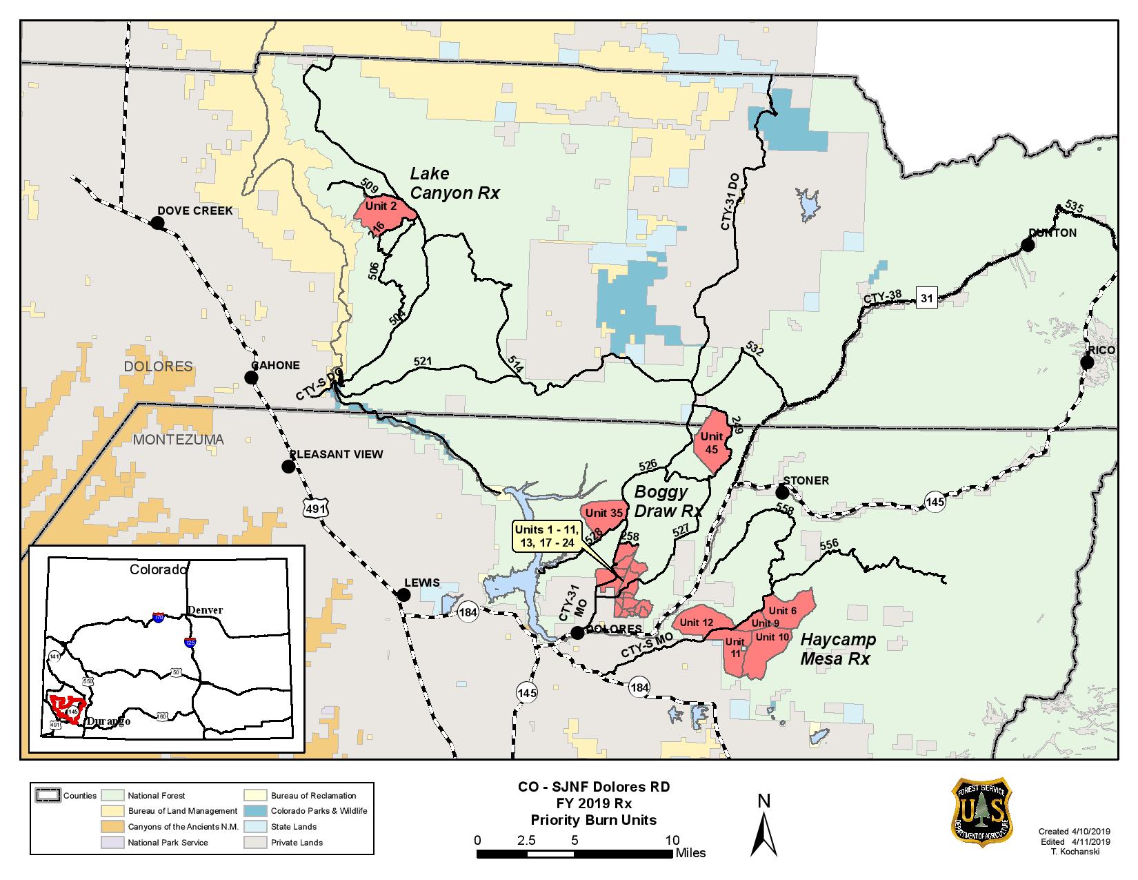
Dolores, Colo., April 11, 2019 –The Dolores Ranger District, San Juan National Forest is planning to conduct several prescribed burns starting in mid-May. Burning operations will take place over multiple days when weather and fuel conditions are favorable. Both hand and aerial ignition methods may be utilized, and continue throughout the summer and into fall based on conditions.
Project areas identified for burn implementation are;
- Lake Canyon, 2700 acres, located 12 miles east of Dove Creek, west of Forest Service Road (FSR) 504 and adjacent to FSR 216 and 509.
- Boggy Draw, 6127 acres along FSR 526, 527, 528 and 529.
- Haycamp Mesa, 3400 acres, east and south of FSR 556 and north of FSR 557.
Burning operations will be conducted by Forest Service personnel, assisted by fire resources from cooperating agencies. During burning operations, smoke will likely be visible from areas around Mancos, Dolores, Dove Creek, Cortez, and HWY 491 between Dove Creek and Pleasant View. Smoke may settle into low lying valleys, and the Dolores River Canyon overnight. Smoke monitoring will be conducted, and ignitions will be scheduled to minimize smoke impacts to communities.
This effort will reduce hazardous ground fuels, lessen the risk of unplanned large scale wildfire, help restore ponderosa pine ecosystems, and improve wildlife habitat. Prescribed burning operations will begin only when weather, fuels and smoke parameters are met. For additional information, please contact Matt Traynham, Assistant Fire Management Officer (Fuels), Dolores Ranger District (970) 882-6838.
Plan for prescribed burning in Pagosa Ranger District
Related Incident:
Publication Type: News
PAGOSA SPRINGS, Colo., April 8, 2019 –The Pagosa Ranger District in San Juan National Forest is planning to conduct several prescribed burns near Pagosa Springs. Burning operations will take place over several days beginning mid-April. Work may continue through June depending on weather and fuel conditions.
Burn units are located in the following areas northwest of town; adjacent to Turkey Springs (FSR Road 629), East Monument (FSR 630), Brockover (FSR 919) and Newt Jack roads (FSR 923). These burn units are within the Brockover I & II, Turkey Springs Piles and Devil Creek II Burn Plans. This year’s efforts expand upon prescribed burning which took place in August/September 2016. It is part of an overall fuels reduction project involving both mechanical treatment and prescribed fire, encompassing approximately 5,000 acres.
Additional burn units are located in Fawn Gulch, Mill Creek and the Piedra River areas. Fawn Gulch are adjacent to Archuleta County Road 113/FSR 666, an area mowed in 2017. Mill Creek are adjacent to Mill Creek Road (Archuleta County Road 302), Nipple Mountain Road (FSR 665) and Echo Canyon Road (FSR 029). These burn units vary in size from 100 to 500 acres. The Piedra River burns include the Horsefly burn units and the Lower Piedra Campground piles.
Burning operations will be conducted by Forest Service personnel, assisted by fire resources from cooperating agencies. The purpose is to reduce hazardous ground fuels, reduce the risk of unplanned large scale wildfires, restore ponderosa pine ecosystems and improve wildlife habitat.
Vegetation in the burn units consists of ponderosa pine, Gambel oak, grass, and small pockets of logging slash. All of the units have received previous fuels-reduction treatments such as mowing of shrubs and small trees, thinning and piling, and timber harvest. Ponderosa pine forests are a fire adapted ecosystem, which historically experienced frequent, low intensity fires on a large scale. Prescribed fire replicates that fire regime under controlled conditions.
Prescribed fires will only be ignited when all weather, fuels and smoke requirements are met. For additional information, please contact Fred Ellis, Assistant Fire Management Officer (Fuels), Pagosa Ranger District (970) 264-1541.
Prescribed Fires near Tusayan tentatively planned for Apr 68
Related Incident: Kaibab NF South Zone Rx Fire
Publication Type: News
This Wednesday through Friday, April 6-8, fire managers are tentatively planning to continue treatments on the Reed Prescribed Fire Project near Tusayan. Pending favorable conditions crews will conduct up to 300 acres of broadcast burning (applying fire across the forest floor) on the Upper Ten-X unit northeast of town.
The National Weather Service is predicting a chance of rain/snow on Monday which could delay operations, potentially to the following week. Precipitation is one of many factors that affect plans to burn. When the ground is too wet, fire cannot effectively move across the forest floor or fully consume the fuels, creating smoke but not meeting restoration objectives.
When crews move forward with ignitions, smoke may be visible from State Route 64, Tusayan, and the Grand Canyon and is expected to disperse northeast during the day. Residual smoke will settle into drainages and low-lying areas around Tusayan overnight. The portion of the Arizona Trail that is nearby will remain open.
This spring, fire mangers on the Williams and Tusayan Ranger Districts are planning treatments on the following projects:
Greenbase Project: Just north of the City Williams; 3500 acres; Smoke likely noticeable around Williams, Highway 64, and Interstate 40. - Marteen Project: Five miles northwest of Spring Valley; 4200 acres; Smoke possible in the areas of Spring Valley Cabin and Forest Road 141.
Reed Project: Just south and northeast of Tusayan; 3300 acres; Overnight smoke generally settles around Forest Road 302, Tusayan, and south toward Red Butte. Blue Stem Project: Remote corner of Tusayan District 15-20 miles east northeast of State Route 64 and Red Butte; Total of approx. 6000 acres; Limited smoke on local roads; minimal impacts to populated areas.
Fire plays a critical role in maintaining a healthy forest and reducing risks of uncharacteristic wildfires that threaten public health and safety. A healthy forest is a resilient forest where fire occurs on regular basis.
Fire managers recognize that smoke can impact residents and visitors. However, because crews have some control over when and how the beneficial fires occur on the landscape, science shows that the amount and duration of smoke from such fires are significantly less than smoke from severe, intense wildfires. The Kaibab National Forest coordinates closely with partners and communities to identify objectives and develop sound and well-informed strategies which include monitoring multiple conditions and taking actions minimize smoke impacts as much as possible.
All prescribed fires on the Kaibab National Forest are subject to approval by the Arizona Department of Environmental Quality. The department provides details about its air quality program online at legacy.azdeq.gov/environ/air/smoke/index.html
Additional fire information for the Kaibab National Forest is available through the following sources:
Fire Information Recorded Hotline: 928-635-8311 Twitter: www.twitter.com/KaibabNF Kaibab Facebook: www.facebook.com/KaibabNF Kaibab website “Recent News”: www.fs.usda.gov/kaibab
Winter Pile Burns Begin on Kaibab National Forest at Various Locations
Related Incident: Kaibab NF South Zone Rx Fire
Publication Type: News
Williams, Arizona, January 3, 2022 — Prescribed fire pile burning will be occurring across the south zone of the Kaibab National Forest beginning the first week of January on both the Williams and Tusayan Ranger Districts.
Winter weather with snow on the ground present excellent opportunities every year for fire crews to burn and consume piled slash and woody debris left over from previous forest restoration projects. For the month of January, approximately 1100 acres of piles south and southwest of the city of Williams are planned for burning with an additional 500 acres on the Tusayan Ranger District.
Operations will be focused on the Williams district this week. On Monday January 3, about 11 acres of piles will be ignited near the peak of Bill Williams Mountain. The following two days crews will be working on the south side of the mountain and along forest road 122 burning another 1100 acres by the weekend.
Smoke will likely be visible from the City of Williams and several areas surrounding these burns including by travelers on Perkinsville Road (FS-73) and Interstate 40.
Smoke production is expected to be minimal after the first few hours with rapid dispersion as piles consume. Some smoke has potential to settle overnight into the lower elevations including on the 73-road due to fluctuating atmospheric temperatures that produce nighttime inversions.
Forest visitors are asked to avoid active hot areas and are reminded to use caution and drive with heightened awareness when passing through any prescribed fire project vicinity.
All prescribed burning on the Kaibab National Forest is subject to approval by the Arizona Department of Environmental Quality.
For additional information about the Smoke Management Division of the ADEQ and to view prescribed burn authorizations, please visit: legacy.azdeq.gov/environ/air/smoke/index.html
Additional fire information for Kaibab National Forest can be obtained through the following sources:
Fire Information Recorded Hotline: 928-635-8311
Twitter: www.twitter.com/KaibabNF
Kaibab Facebook: www.facebook.com/KaibabNF
Kaibab website “Recent News”: www.fs.usda.gov/kaibab
Kaibab South Zone Rx Fire: inciweb.nwcg.gov/incident/5922/
Treatments Continuing on Reed Rx Fire Project Near Tusayan This Month
Related Incident: Kaibab NF South Zone Rx Fire
Publication Type: News
Tusayan Arizona, December 01, 2021 — The Upper Ten X units on the Reed Prescribed Fire Project located 3 miles east of the Town of Tusayan will be active over the next few weeks as weather permits. Kaibab National Forest fire crews will continue low intensity surface burning to reduce fuel loads in forested areas around the community of Tusayan increasing protection from potential negative effects of uncontrolled wildfire.
Beginning Friday December 3, crews will use hand ignitions to burn a 64-acre unit, and then continue with a series of units the following week. The intent is to burn smaller blocks early in the day to allow time for smoke to lift and ventilate away reducing smoke impacts to rural areas nearby. Managers try to schedule units for treatment every few days leaving openings between burns to assist with managing air quality and allow for good smoke dispersion.
Smoke is forecasted to ventilate away from Tusayan during the day, but residual smoke may settle into drainages and low-lying areas overnight due to atmospheric inversion. Some smoke will likely be visible in Tusayan and along Highway 64 in the early morning hours after a burn, however, will generally clear rapidly as surface temperatures increase with sunrise.
The Arizona Trail adjacent to the area being treated will remain open. Hikers and trail users are asked to follow directions posted and comply with any temporary detours that may be in place during operations. Visitors should always use extra caution when passing through any area where prescribed burns are occurring.
The Kaibab National Forest is a fire adapted ecosystem. It is dependent on fire to play a natural role in maintaining vibrant forest health. Lack of fire in the forest has caused an abundance of fuels to build up, which can make the forest vulnerable and susceptible to more dangerous uncontrollable fire incidents. Reintroducing fire back into the ecosystem is a very effective tool to reduce fuel loads and restore the landscape back to a healthier state that is more aligned with historical conditions.
All prescribed burning on the Kaibab National Forest is subject to approval by the Arizona Department of Environmental Quality.
For additional information about the Smoke Management Division of the ADEQ and to view prescribed burn authorizations, please visit: legacy.azdeq.gov/environ/air/smoke/index.html
Additional fire information for Kaibab National Forest can be obtained through the following sources:
Fire Information Recorded Hotline: 928-635-8311
Twitter: www.twitter.com/KaibabNF
Kaibab Facebook: www.facebook.com/KaibabNF
Kaibab website “Recent News”: www.fs.usda.gov/kaibab
Kaibab South Zone Rx Fire: inciweb.nwcg.gov/incident/5922/
Prescribed Burns Continue on Kaibab National Forest
Related Incident: Kaibab NF South Zone Rx Fire
Publication Type: News
Williams, Arizona, Nov 14, 2021 — Prescribed fire operations will continue in the week ahead on both the Tusayan and Williams Ranger Districts at three project locations on the south zone of the Kaibab National Forest.
On Monday, November 15, ignitions will occur on the Reed Rx Project: “Skinner North Unit”, 6 miles southeast of Tusayan. This unit is approximately 1400 acres in size. A helicopter may be utilized to conduct aerial ignitions providing conditions are suitable to meet objectives.
On Tuesday November 16, 155 acres on the “Upper Ten X Unit”, 3 miles east of Tusayan will be treated.
Both these burns will produce visible smoke have the potential to impact Highway 64 and the community of Tusayan with early morning smoke caused by overnight inversion. Smoke is expected to lift and ventilate out rapidly by about 9:00 am each morning.
The Grand Canyon National Park may also be conducting prescribed fire operations on the south rim in the same general vicinity which may also have potential smoke impacts on local communities.
On Wednesday November 17, crews will shift operations to the Williams Ranger District and begin ignitions on the Marteen Rx Project: “Backward Unit”, located 5 miles north of Spring Valley, and west of forest road 144. Approximately 1028 acres are scheduled for treatment on this unit. Aerial ignitions from a helicopter may also be used on this project to shorten ignition time and allow more hours in the day for ventilation reducing long term smoke impacts.
Smoke will be visible from Highways 64 and 180 and have potential to drift into the communities of Red Lake and Valle overnight.
Prescribed fire is used fire as a practical means to reduce risks associated with uncharacteristic wildfires that can pose significant threats to public health and safety. On each day, fire managers evaluate local conditions that include weather patterns, temperatures, relative humidity, wind speed and direction, fuel moistures, and smoke ventilation. Daily ignitions will only occur when environmental factors align with the required prescription that will achieve desired results and meet land management objectives.
The Forest Service’s land management strategy is centered on long-term forest health, which includes reducing forest fuels and using prescribed fire on the landscape.
Although impacts to air quality may be unpleasant at times, the objective is to significantly reduce the amount and limit the duration of smoke more effectively using prescribed methods. Fire managers will actively monitor atmospheric conditions daily and use strategies to minimize smoke impacts to rural developed areas.
During operations, fire personnel and vehicles working in these vicinities may be visible to the public. Motorists are reminded to slow down and drive with heightened caution when passing through active project areas.
All prescribed burning on the Kaibab National Forest is subject to approval by the Arizona Department of Environmental Quality. For additional information about the Smoke Management Division of the ADEQ and to view prescribed burn authorizations, please visit: legacy.azdeq.gov/environ/air/smoke/index.html
For additional information about prescribed fires on the Kaibab National Forest, please visit the following sources:
Fire Information Recorded Hotline: 928-635-8311
Twitter: www.twitter.com/KaibabNF
Kaibab Facebook: www.facebook.com/KaibabNF
Kaibab website “Recent News”: www.fs.usda.gov/kaibab
Kaibab South Zone Rx Fire: inciweb.nwcg.gov/incident/5922/
Prescribed Burns to Occur at Multiple Locations on Tusayan Ranger District
Related Incident: Kaibab NF South Zone Rx Fire
Publication Type: News
Tusayan, Arizona, Nov 8, 2021 — A series of prescribed fire projects will begin today and continue throughout the week at various locations across the Tusayan Ranger District on the Kaibab National Forest. Approximately 3200 acres are scheduled to be ignited at the following specific locations beginning Monday, November 8, and continuing through Friday November 12.
Reed Rx Project: Upper Ten X Unit, 3 miles east of Tusayan. (241 acres)
Reed Rx Project: Skinner North Unit, 6 miles southeast of Tusayan (1560 acres)
Blue Stem Rx Project: Camp 36 Unit, 12 miles southeast of Tusayan (1100 acres)
Blue Stem Rx Project: Skousen Unit, 18 miles southeast of Tusayan, (300 acres)
A helicopter may be utilized to conduct aerial ignitions on the larger units once operations begin. Burning the units rapidly and earlier in the day provides more time for smoke to lift and ventilate away reducing overnight inversion and long-term impacts to local areas.
Prescribed fire is used fire as a practical means to reduce risks associated with uncharacteristic wildfires that can pose significant threats to public health and safety. On each day, fire managers evaluate local conditions that include weather patterns, temperatures, relative humidity, wind speed and direction, fuel moistures, and smoke ventilation. Daily ignitions will only occur when environmental factors align with the required prescription that will achieve desired results and meet land management objectives.
The Forest Service’s land management strategy is centered on long-term forest health, which includes reducing forest fuels and using prescribed fire on the landscape. A healthy forest is a resilient forest that undergoes fire occurrences on a regular basis. The Kaibab National Forest works with partners, collaborators, and communities to clearly identify objectives and address concerns during the planning process for prescribed fires.
Officials recognize that impacts to air quality may be unpleasant at times, however they can significantly reduce the amount and limit the duration of smoke more effectively using prescribed methods than in an uncontrolled wildfire situation. Additionally, fire managers will actively monitor atmospheric conditions daily and use strategies to minimize smoke impacts to rural developed areas.
During operations, fire personnel and vehicles working in these vicinities may be visible to the public. Motorists are reminded to slow down and drive with heightened caution when passing through active project areas.
All prescribed burning on the Kaibab National Forest is subject to approval by the Arizona Department of Environmental Quality. For additional information about the Smoke Management Division of the ADEQ and to view prescribed burn authorizations, please visit: legacy.azdeq.gov/environ/air/smoke/index.html
Fire information for Kaibab National Forest can be obtained from the following sources:
Fire Information Recorded Hotline: 928-635-8311
Twitter: www.twitter.com/KaibabNF
Kaibab Facebook: www.facebook.com/KaibabNF
Kaibab website “Recent News”: www.fs.usda.gov/kaibab
Kaibab South Zone Rx Fire: inciweb.nwcg.gov/incident/5922/