
2021 Dolores Ranger District Prescribed Fire Update
Related Incident:
Publication Type: News
DOLORES, Colo., March 17, 2021—The San Juan National Forest’s Dolores Ranger District is planning to conduct several prescribed burns starting in April. Burning operations will take place over multiple days when weather and fuel conditions are favorable and may continue throughout the summer and into fall based on conditions. Both hand and aerial ignition methods may be utilized, following the weather, fuel and smoke parameters stated in the prescribed fire plan. Burning operations will be conducted by U.S. Forest Service personnel assisted by fire resources from cooperating agencies.
Project areas identified for burn implementation are:
Haycamp Mesa: 5,131 acres located 10 miles east of Dolores along Haycamp Mesa Road, (NFSR 556).
Boggy Draw: 5,041 acres located 3 to 15 miles northeast of Dolores, along the Dolores-Norwood Road near Little Bean Canyon, Boggy Draw Road (NFSR 527), and Cottonwood Canyon Road (NFSR 532).
Salter: 3,904 acres located 7 to 15 miles east of Cahone, near Salter Y and Ormiston Point Road (NFSR 521).
Reintroduction of prescribed fire is necessary to improve and restore vegetative conditions. This effort will reduce hazardous ground fuels, lessen the risk of unplanned large-scale wildfire, help restore ponderosa pine ecosystems, and improve wildlife habitat. Prescribed fire also reduces the ladder fuels that can carry fire into the canopy, killing mature trees.
During burning operations, smoke may be visible around Mancos, Dolores, Dove Creek, Cortez, and Highway 491 between Dove Creek and Pleasant View. Smoke may settle into low lying valleys and the Dolores River Canyon overnight. Smoke monitoring will be conducted and ignitions will be scheduled to minimize smoke impacts to communities. Prescribed fire smoke may affect your health. More information can be found online: https://www.colorado.gov/pacific/cdphe/wood-smoke-and-health
Maps of the prescribed burn units and additional San Juan National Forest prescribed fire program news can be found on InciWeb: https://inciweb.nwcg.gov/incident/6288/. For more information, please contact Acting Fuels Assistant Fire Management Officer Dan Kaufenberg by email at Daniel.kaufenberg@usda.gov or by phone at (970) 882-6834.
All offices on the San Juan National Forest are currently conducting business and providing services virtually. For information on the San Juan National Forest, call (970) 247-4874, visit the forest website, or follow us on social media (Twitter and Facebook).
2021 Columbine Ranger District Prescribed Fire Update
Related Incident:
Publication Type: News
Media contact: Lorena Williams (970) 422-2939 Lorena.williams@usda.gov
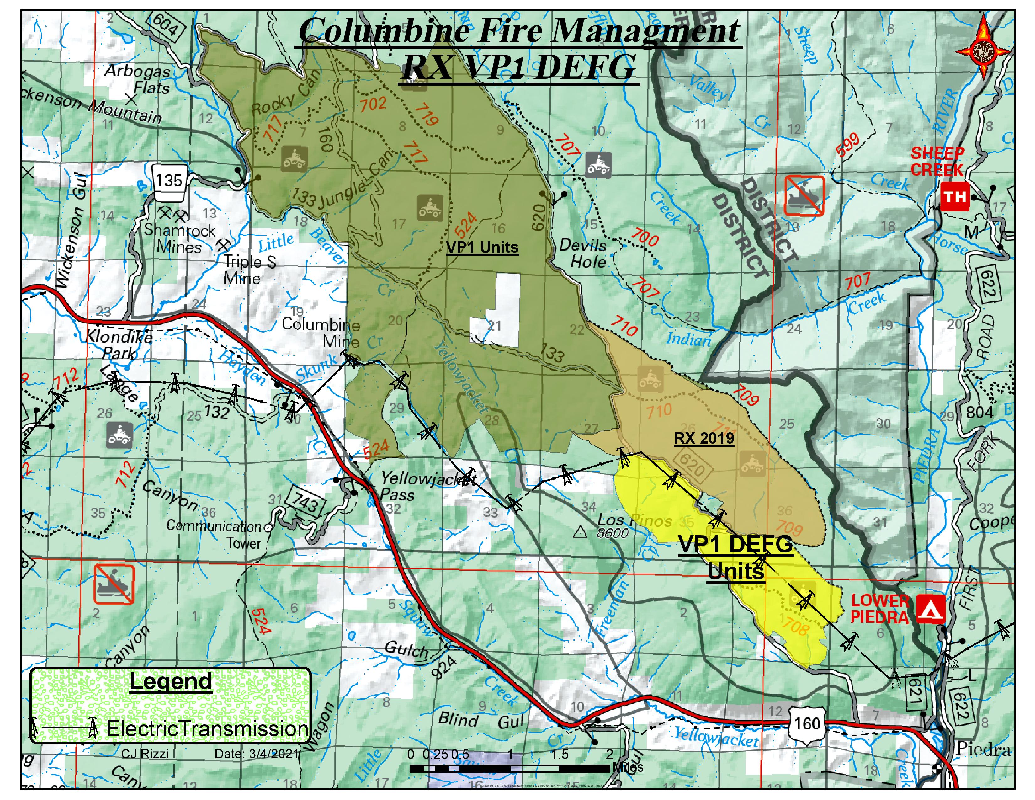
BAYFIELD, Colo., March 15, 2021— The Columbine Ranger District is planning a prescribed burn this spring in the Beaver Meadows/First Notch areas of the San Juan NF. Weather permitting, burning operations in the area will begin in early April and could continue through early May. The Vallecito-Piedra project may take several weeks to complete. This planned event will use both ground and aerial ignition methods while following the weather and fuel parameters stated in the prescribed fire plan.
The Vallecito-Piedra prescribed fire encompasses a total of approximately 3,500 acres between Beaver Creek Road and First Notch Road, north of Highway 160 between Bayfield and Pagosa Springs. Only 1,051 acres are planned for spring prescribed fire; the remaining acres are planned for Autumn of 2021.
Reintroduction of prescribed fire is necessary to improve and restore vegetative conditions. The prescribed burns will improve habitat for deer and elk by encouraging re-sprouting of oak and allowing sunlight to stimulate the growth of grasses and forbs. These projects are also designed to improve the health of ponderosa pine stands by reducing competition from Gambel oak, removing ground litter to expose mineral soil for seed germination, and releasing natural minerals and nutrients into the soil. Prescribed fire also reduces the ladder fuels that can carry fire into the canopy, killing mature trees.
Daytime smoke is expected to travel to the north/northeast and to be lofted high into the atmosphere. However, nighttime smoke will travel downslope into the Beaver Creek drainage, the Piedra River, and south to the Pine River just north of Ignacio. Smoke will be heavier in the mornings following burning operations, lifting and clearing out by mid-day, and will be visible from Bayfield, Pagosa Springs, and along the Highway 160 corridor between those two towns. Prescribed fire smoke may affect your health. For more information see: https://www.colorado.gov/pacific/cdphe/wood-smoke-and-health
Maps of the prescribed burn units and additional San Juan National Forest prescribed fire program news can be found on InciWeb: https://inciweb.nwcg.gov/incident/6288/. For more information, please contact Columbine District Fuels Assistant Fire Management Officer Noah Daniels by email at noah.daniels@usda.gov or by phone at (970) 884-1430.
All offices on the San Juan National Forest are currently conducting business and providing services virtually. For information on the San Juan National Forest, call (970) 247-4874, visit the forest website, or follow us on social media (Twitter and Facebook).
Pile Burns planned for Columbine Ranger District
Related Incident:
Publication Type: News
Media Contact: Esther Godson Email: esther.godson@usda.gov Telephone: 970-385-1219
Durango, CO., November 27, 2019 - The San Juan National Forest Columbine Ranger District plans to burn slash piles beginning in early December. These piles were generated from forest thinning projects to improve forest health, resiliency, and mitigate wildfire risk. Although burning could continue through April, these activities should not affect public access or use of the forest. Operations typically take place after snowfall and firefighters will ignite and closely monitor pile-burning activities.
The slash piles are located in the Rockwood area north of Hermosa; smoke may be visible from Highway 550. Additional piles are between the Enchanted Forest and Tween Lakes subdivisions on the north side of CR 240; smoke may be visible in those subdivisions and along CR 240.
Prescribed fire smoke may affect your health. For more information, please go to: https://www.colorado.gov/pacific/cdphe/wood-smoke-and-health
For additional information on Columbine Ranger District area pile burns, please contact the Columbine Ranger District office at (970) 884-1425.
For information on prescribed burns, wildfires and fire restrictions on the San Juan National Forest, call 970 247- 4874, or visit the Forest Website at: http://www.fs.usda.gov/sanjuan/ and follow us on Twitter at: https://twitter.com/SanJuanNF
Pile Burns planned for Dolores and Pagosa Ranger Districts
Related Incident:
Publication Type: News
Media Contact: Esther Godson Email: esther.godson@usda.gov Telephone: 970-385-1219
Durango, CO., November 18, 2019 - The Dolores and Pagosa Districts are planning to burn slash piles this week. Piles were generated from forest thinning, timber sales, and fuels reduction projects in areas targeted to reduce wildfire hazards to nearby private residences and other infrastructure. Although burning could continue through the winter, these activities should not affect public access or use of the forest. Operations typically take place after significant precipitation events and firefighters will closely monitor pile-burning activities.
Pile burning will take place in the following locations:
Dolores Ranger District:
Chicken Creek area, seven miles north of Mancos, near FSR #385, two miles northeast of Joe Moore Reservoir. Piles may also be burned adjacent to Joe Moore Reservoir along FSR #693. Smoke may be visible from highway 184.
Haycamp Mesa area, near FSR #556 and #556.D, South of Beef Pasture Reservoir. Smoke may be visible from highway 184. Spring Creek area, 12 miles north of Mancos, near FSR #327 and #382. Smoke may be visible from highway 184. Taylor Mesa Area, eight miles northeast of the confluence of the Dolores and West Dolores Rivers, near FSR #547 and Fox Den Creek. Smoke may be visible along highway 145. Lake Canyon Area, 10 miles east of Dove Creek, FSR #504/505 near Big Water Spring, FSR #509 near Glade Point, and FSR #506 near Cow Canyon. Smoke may be visible from highway 491.Pagosa Ranger District:
Turkey Springs FSR #629, Cabazon Canyon (Forest Service land adjacent to Archuleta County Road 917). Smoke may be visible from highway 160, 151 and Archuleta County Road 600.
Highway 151 area north of Southern Ute land. Smoke may be visible from highway 151 and 160.
Prescribed fire smoke may affect your health. For more information, please go to: https://www.colorado.gov/pacific/cdphe/wood-smoke-and-health
For additional information on Dolores area pile burns, please contact the Dolores Ranger District Office at (970) 882-6838.
For additional information on Pagosa Springs area pile burns, please contact the Pagosa Ranger District Office (970) 264-1541.
For information on prescribed burns, wildfires and fire restrictions on the San Juan National Forest, call 970 247- 4874, or visit the Forest Website at: http://www.fs.usda.gov/sanjuan/ and follow us on Twitter at: https://twitter.com/SanJuanNF
Dolores Ranger District Plans to Burn Slash Piles
Related Incident:
Publication Type: News
Dolores Ranger District Plans to Burn Slash Piles
Contact: matthew.traynham@usda.gov Telephone: 970-882-6838
DOLORES, Colo., October 28, 2019 – The San Juan Forest Dolores Ranger District plans to burn slash piles generated from forest thinning and timber sales in the Chicken Creek, Spring Creek, Taylor Mesa and Lake Canyon areas. Although burning could continue through April, these activities should not affect public access or use of the forest. Operations typically take place after snowfall occurs and firefighters will ignite and closely monitor pile- burning activities.
In the Chicken Creek area, seven miles north of Mancos, piles may be burned near FSR #385, two miles northeast of Joe Moore Reservoir. Piles may also be burned adjacent to Joe Moore Reservoir along FSR #693. Smoke may be visible from highway 184.
• In the Haycamp Mesa area, piles may be burned near FSR #556 and #556.D, South of Beef Pasture Reservoir. Smoke may be visible from highway 184.
• In the Spring Creek area, 12 miles north of Mancos, piles may be burned near FSR #327 and #382. Smoke may be visible from highway 184.
• In the Taylor Mesa Area, eight miles northeast of the confluence of the Dolores and West Dolores Rivers, piles may be burned near FSR #547 and Fox Den Creek. Smoke may be visible along highway 145.
• In the Lake Canyon Area, 10 miles east of Dove Creek, piles may be burned near FSR #504/505 near Big Water Spring, FSR #509 near Glade Point, and FSR #506 near Cow Canyon. Smoke may be visible from highway 491.
For additional information, please contact the Dolores District Office at 970 882-7296.
Prescribed fire smoke may affect your health. For more information, please go to: https://www.colorado.gov/pacific/cdphe/wood-smoke-and-health.
For information on prescribed burns, wildfires and fire restrictions on the San Juan National Forest, call 970 247-4874, visit the Forest Website at: http://www.fs.usda.gov/sanjuan/ , or follow us on Twitter at: https://twitter.com/SanJuanNF
Prescribed burning complete on both Pargin and Brockover Prescribed Burns
Related Incident:
Publication Type: News
Prescribed burning operations are now complete in both the Pargin Prescribed Burn and the Brockover Prescribed Burn on the San Juan National Forest
The Columbine Ranger District has completed prescribed burn activities in the Pargin Prescribed Burn, located east of Bayfield Colorado. Aerial ignitions and hand lighting over three days accomplished 5725 acres of prescribed burning. Smoke will likely continue to be visible at times from Bayfield and along Hwy. 160, and will likely settle in low lying areas tonight. For more information, please contact the Columbine Ranger District at 970-884-2512.
Yesterday, the Pagosa Ranger District completed prescribed fire operations in the Brockover Prescribed Burn unit, in the Turkey Springs/Brockover Mesa area west of Pagosa Springs. Smoke will be visible from U.S. Highway 160, Bayfield, and the upper Piedra area. Smoke is expected to move northeast, but will settle into lower lying areas at night. For more information, contact the Pagosa Ranger District Office at 970-264-2268.
After completing the planned ignitions, firefighters will remain on scene to patrol and monitor the perimeter as long as necessary.
Ponderosa pine forests are a fire adapted ecosystem, which historically experienced frequent, low intensity fires on a large scale. Prescribed fire replicates that fire regime under controlled conditions, reduce the risk of future wildfires, and improve wildlife habitat.
Aerial Ignitions planned in VallecitoPiedra prescribed burn units
Related Incident:
Publication Type: News
On the Columbine Ranger District, approximately 700 acres in the Vallecito-Piedra prescribed burn unit are planned for aerial ignitions using a Type 3 helicopter tomorrow Tuesday September 10th. Favorable weather conditions are forecast. This would complete planned prescribed burn operations for the southern portion of Vallecito-Piedra 1 burn units.
Prescribed Burns to Continue Through Weekend on Columbine Ranger District
Related Incident:
Publication Type: News
BAYFIELD, Co., September 6, 2019 –After test-firing the unit on Thursday, more than 75 firefighters successfully implemented 60 acres of prescribed burning in the southern portion of the Vallecito-Piedra (VP) Prescribed Burn Unit 1 in the First Notch area. This burn will set the stage for prescribed burning through the weekend and beyond, as fire management personnel experienced good burning conditions throughout the day. We expect to continue burning the lower elevation portions of the VP Unit 1.
On Saturday, firefighters will continue hand ignitions on the southeastern portion of the unit. This will help ensure the burn stays within established control lines and maintain desired fire effects. Sunday, firefighters expect to complete the southern portion of the burn with both hand and aerial (helicopter) ignitions, implementing a total of approximately 1,400 acres of prescribed burn. After completing the planned ignitions, firefighters will remain on scene to patrol and monitor the perimeter as long as necessary.
Smoke will likely be visible well into next week, usually settling into low-lying areas at night, potentially causing visibility impacts to the south and east at times. The smoke will dissipate through the afternoon.
As with any prescribed fire, the fire area can be dangerous to the public and to firefighters. Forest users are asked to stay out of the burned area, and to be vigilant for fire traffic, falling trees, and other hazards when traveling down FS620.
Prescribed fire smoke may affect your health. For more information see: https://www.colorado.gov/pacific/cdphe/wood-smoke-and-health.
Up-to-date information on the San Juan National Forest Prescribed Burn Program can be found on InciWeb at https://inciweb.nwcg.gov/incident/6288/.
Follow us on Facebook at: https://www.facebook.com/SanJuanNF/ and on the Forest Website at: http://www.fs.usda.gov/sanjuan/.
###
USDA is an equal opportunity provider, employer, and lender
Prescribed Burns Planned for Turkey SpringsBrockover Mesa Area
Related Incident:
Publication Type: News
PAGOSA SPRINGS, Colo, September 6, 2019 – The Pagosa Ranger District is planning to burn approximately 1,500 acres in the Turkey Springs/Brockover Mesa area west of Pagosa Springs, CO. The units are between the Newt Jack Trail and the TriState powerline. Operations may begin September 10, 2019. The actual dates of operations will be dependent on weather and fuels conditions.
Ignition operations may take place over several consecutive days. The units consist of ponderosa pine, Gambel oak and grass. The area has received previous fuels-reduction treatments. This Turkey Springs/Brockover Mesa project expands upon previous prescribed fires. It is part of an overall fuels reduction project involving both mechanical treatment and prescribed fire covering approximately 5,000 acres.
Burning operations will be conducted by district personnel and other fire resources from the San Juan National Forest, other Forest Service units and cooperating agencies. The purpose is to reduce hazardous ground fuels, reduce the risk of unplanned catastrophic wildfire, restore ponderosa pine ecosystems and improve wildlife habitat.
Smoke will be visible from U.S. Highway 160, the Town of Pagosa Springs, Aspen Springs and the upper Piedra area. Smoke is expected to move northeast, but will settle into lower lying areas at night.
Ponderosa pine forests are a fire adapted ecosystem, which historically experienced frequent, low intensity fires on a large scale. Prescribed fire replicates that fire regime under controlled conditions. Prescribed fires will only be ignited when all weather, fuels and smoke requirements are met.
For additional information, please contact the Pagosa Ranger District at 970-264-2268.
Smoke from wildfires and prescribed fires may affect your health. For more information, please go to: https://www.colorado.gov/pacific/cdphe/wood-smoke-and-health.
The following links are for smoke monitors in the Pagosa Lakes area: https://wrcc.dri.edu/cgi-bin/rawMAIN4.pl?ids456+20+08+19+M https://www.purpleair.com/map?#8.8/37.1528/-106.7232
###
USDA is an equal opportunity provider, employer, and lender.
Prescribed Burn Planned for Pargin Mtn and Beaver MeadowsFirst Notch Areas
Related Incident:
Publication Type: News
BAYFIELD, Co., September 4, 2019 –The Columbine Ranger District is planning a prescribed burn this fall in the Pargin Mountain and the Beaver Meadows/First Notch areas of the San Juan National Forest 10 to 18 miles east of Bayfield. Burning operations in the area may continue through October, weather permitting. This planned event will use both ground and aerial ignition methods, while also following the weather and fuel perimeters stated in the prescribed burn plan.
Vallecito-Piedra (VP) Unit 1
The VP Unit 1 prescribed burn encompasses a total of 5,771 acres between Beaver Creek Road and First Notch Road, north of highway 160 between Bayfield and Pagosa Springs.
Pargin
The Pargin prescribed burn covers just under 5675 acres south of highway 160 between Bayfield and Pagosa Springs. This unit was last burned in 2016.
The VP Unit 1 prescribed burn will begin Thursday, September 5 weather permitting. The project will take about a week. Crews will begin work on the Pargin prescribed burn after completing VP Unit 1. The Pargin prescribed burn will also take about a week.
Reintroduction of prescribed burning is necessary to improve and restore vegetative conditions. The prescribed burns will improve habitat for deer and elk by encouraging re-sprouting of oak and allowing sunlight to stimulate the growth of grasses and forbs. These projects are also designed to improve the health of ponderosa pine stands by reducing competition from Gambel oak, removing ground litter to expose mineral soil for seed germination, and releasing natural minerals and nutrients into the soil. Prescribed burning also reduces the ladder fuels that can carry fire into the canopy, killing mature trees.
Daytime smoke is expected to travel to the north/northeast and to be lofted high into the atmosphere. However, nighttime smoke will travel downslope into the Beaver Creek drainage, the Piedra River, and south to the Pine River just north of Ignacio. Smoke will be heavier in the mornings following burning operations, lifting and clearing out by mid-day. Prescribed fire smoke may affect your health. For more information see: https://www.colorado.gov/pacific/cdphe/wood-smoke-and-health.
For more information call 970-884-2512. Up-to-date information on the San Juan National Forest Prescribed Burn Program can be found on InciWeb at https://inciweb.nwcg.gov/incident/6288/.
Follow us on Facebook at: https://www.facebook.com/SanJuanNF/ and on the Forest Website at: http://www.fs.usda.gov/sanjuan/.
###
USDA is an equal opportunity provider, employer, and lender