
Smoke Outlook March 30 03 30 2025
Related Incident: Big Ridge Fire
Publication Type: News
SMOKE
Decreased fire activity and winds from the south will likely combine to reduce smoke in the forecast area. Clemson, Greenville, and Spartanburg will likely have MODERATE to GOOD air. Taylors, Pickens, and Sky Valley will have air that is MODERATE, with potential periods of UNHEALTHY FORSENSITIVE GROUPS. Catawba Nation will likely have GOOD air quality.
SPECIAL STATEMENT
Stay informed of evacuation orders, airquality alerts, fire danger information,and other public safety advisories inyour area. Due to erratic winds fromincoming thunderstorms and largenumber of fires in the area, smokeimpacts have the potential to changequickly.
HEALTH STATEMENT
Smoke can be harmful to your health. Check with your doctor if there are any health concerns and monitor your local air quality conditions using the Fire and Smoke Map.
Rattlesnake Branch Daily Update March 29 2025 03 29 2025
Related Incident:
Publication Type: News
U.S. Forest Service News Release
Media Contact:
Southern Area Red Team
2025.RattlesnakeBranch@firenet.gov
(828) 519-8242
https://inciweb.wildfire.gov/incident-information/ncncf-rattlesnake-branch
https://www.facebook.com/nfsnc/
Rattlesnake Branch Fire Daily Update -- March 29, 2025
Note: Please drive cautiously on Road 276 and other roads around the fire. Please do not stop along the side of the road for your protection and the protection of firefighters and equipment.
CLYDE, N.C., March 29, 2025--The Rattlesnake Branch Fire is on private land and the Shining Rock Wilderness Area on Pisgah National Forest around the community of Cruso, approximately 11 miles southeast of Waynesville, North Carolina. It started on March 26, 2025, and quickly spread due to dry conditions and hardwood leaves and branches on the ground. The cause is under investigation.
The fire is approximately 1,200 acres and 20-percent contained. More than 80 personnel are on the fire, with more firefighters and equipment on the way.
Yesterday’s Activities
Firefighters made good progress protecting homes in Cruso yesterday. They put in a fire containment line between the area where the fire started and Cold Creek, allowing them to burn around homes, igniting from the ground and from a helicopter to reduce burnable vegetation and secure homes. In the Crawford Creek area, the fire continued to flank uphill. Firefighters used tactical burning to keep the fire above homes in this area. They also provided structure protection as a precautionary measure to reduce their fire risk. The fire continued to burn throughout the night under the watch of night crews.
The Southern Area Red Complex Incident Management Team arrived to help the Pisgah National Forest manage the fire.
Today’s Activities
This morning, the Southern Area Red Team joined command of the Rattlesnake Branch Fire. Crews will continue to protect homes in Cruso and identify areas for putting in more bulldozer fire lines from Cold Creek to Burnett Cove to protect private property. They will do strategic firing operations from helicopter, backing the fire down to reduce the risk of it running uncontrolled upslope and potentially spotting into drainages to the west.
Firefighters will continue to keep the fire from burning downhill towards homes in the Crawford Creek area and will expand assessment of structures needing protection, working westward. They will put in a fire containment line and begin to improve road access for firefighting efforts.
Helicopters and fixed-wing “super scoopers” are available to help fight the fire.
Weather/Fire Behavior: Today will be mostly cloudy, moderating fire behavior. Temperature highs will be in the mid-60s with relative humidity in the mid-40s percent. Winds will be south/southwest 8-14 mph, gusting 20-28 mph.
Dead and down hardwood tree litter, rhododendron and laurel shrubs and conifer species such as white pine are the primary fuels burning in the Rattlesnake Branch Fire. With fire activity expected to be minimal today due to the weather, fire behavior analyst Gary Jarvis said to firefighters, “Today should be a good day to get out there and size things up - fire will be on your side today, not the extreme stuff we’ve seen in the past few days.”
Air quality information is available at Smoke Outlook for Western North Carolina and Upstate South Carolina, www.airnow.gov and www.wildlandfiresmoke.net.
Closures and Restrictions: The Pisgah National Forest has issued an area closure of the Shining Rock Wilderness Area to protect the public from wildfire and firefighting operations. This closure includes all National Forest System land between US-276 and NC-215 north of the Blue Ridge Parkway (between mile markers 405 and 420). Please stay safe and keep out of these areas.
Following the statewide burn ban issued for North Carolina, the USDA Forest Service issued a fire restriction on open burning National Forest land, including building, maintaining or using campfires, open stove fires and fire rings, to mitigate wildfire risks.
A temporary flight restriction is in effect in and around the fire area. This includes use of personal drones. If you fly, we cannot fly!
###
USDA is an equal opportunity provider, employer and lender.
Big Ridge Fire Daily Update March 29 03 29 2025
Related Incident: Big Ridge Fire
Publication Type: News
March 29, 2025
Acres: 1,936 acres Start Date: 03/22/2025
Location: Clayton, GA Personnel: 166
Containment: 0% Fuels: Timber
Resources: 8 crews | 6 engines | 2 dozer | 1 helicopter
Highlights: Reduced fire activity is expected today on the Big Ridge Fire because of higher humidity and reduced winds. On Friday, the fire crossed the Bartram Trail near Flat Top, but airtankers kept it from making progress. On the south side, the fire is being held along Hoods Creek. There will be a virtual public meeting today from 12-1 p.m. at https://meet.google.com/qcj-ukgz-mcf or by phone at 440-482-1399, PIN 359 161 763#.
Fire Activity: Today firefighters will be constructing direct line on the part of the fire that crossed the Bartram Trail near Flat Top. On the north side of the fire, crews will be completing handline from Beegum Gap to Hale Ridge Road. Once this line is completed, they will be looking for opportunities to construct direct line on the fire’s edge on the east side. On the southwest side of the fire, crews will be constructing direct line from Walnut Creek to Flat Top following Hoods Creek. Firefighters are also scouting and constructing secondary control lines in case these primary control lines are compromised.
The U.S. Forest Service Law Enforcement and Investigations is seeking information regarding the circumstances around the cause of the Big Ridge Fire. If anyone was in the area on March 22, 2025, and observed suspicious activity please call the Georgia Forestry Commission Arson Hotline 1-800-428-7337.
Weather: Today’s forecast calls for 70 degrees and minimum relative humidity of 40%. Winds will be southeast with sustained speeds of 10 mph and gusts of 15-20 mph. On Sunday there is an 80% chance of showers which continues into Monday. Smoke levels will increase from evening through the morning in the valleys.
Evacuations: None.
Closures: A closure order is in place for the vicinity of the Big Ridge Fire. For details visit https://inciweb.wildfire.gov/incident-closures/gachf-big-ridge-fire
More Information:
Facebook: https://www.facebook.com/ChattOconeeNF
Email: 2025.BigRidge@firenet.gov
Fire Information: 770-530-3950
Inciweb: https://inciweb.wildfire.gov/incident-information/gachf-big-ridge-fire
Pintler Ranger District Rx Fire Operations Spring 2025 03 28 2025
Related Incident: Beaverhead-Deerlodge NF Prescribed Fire Operations
Publication Type: Announcement
The Pintler Ranger District has developed prescribed fire implementation plans for the following units:
Flint Foothills - 11 miles southeast of Drummond
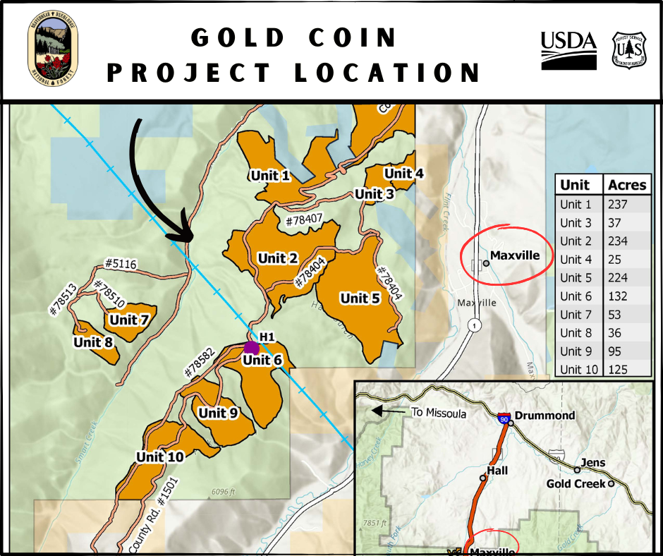
Gold Coin - 2 miles southwest of Maxville
Lone Pine - 18 miles southwest of Philipsburg
East Deer Lodge - 16 miles northeast of Anaconda
Maywood/Meadow Creek - 2 miles northeast of Maxville
Madison Ranger District Rx Fire Operations Spring 2025 03 28 2025
Related Incident: Beaverhead-Deerlodge NF Prescribed Fire Operations
Publication Type: Announcement
The Madison Ranger District has developed prescribed fire implementation plans for the following units:
Greenhorn - 14 miles south of Virginia City
Badger Creek - 21 miles south of Virginia City (Upper Ruby Road)
Antelope - 45 miles south of Ennis, along Highway 87
Magic Feather Update 03 28 2025
Related Incident: Magic Feather Prescribed Burn
Publication Type: Announcement
Crews will continue to patrol and secure the burn perimeter today and into the weekend. Light smoke may be visible. Over the burn area there is a chance of rain tonight and snow into the weekend.
Wisdom Ranger District Rx Fire Operations Spring 2025 03 28 2025
Related Incident: Beaverhead-Deerlodge NF Prescribed Fire Operations
Publication Type: Announcement
The Wisdom Ranger District has developed prescribed fire implementation plans for the following units:
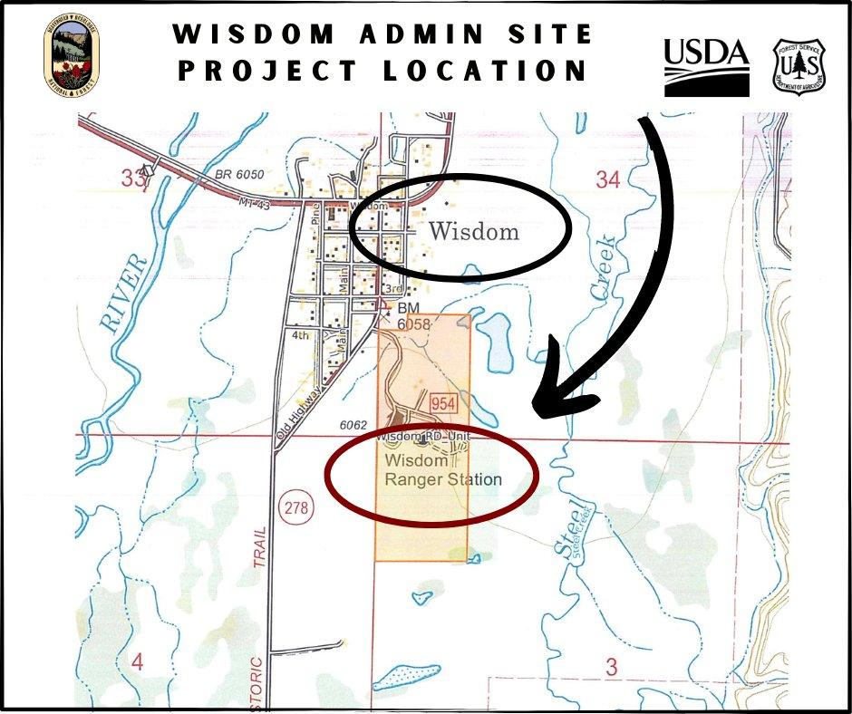
Wisdom Admin Site - just southeast of Wisdom at FS site
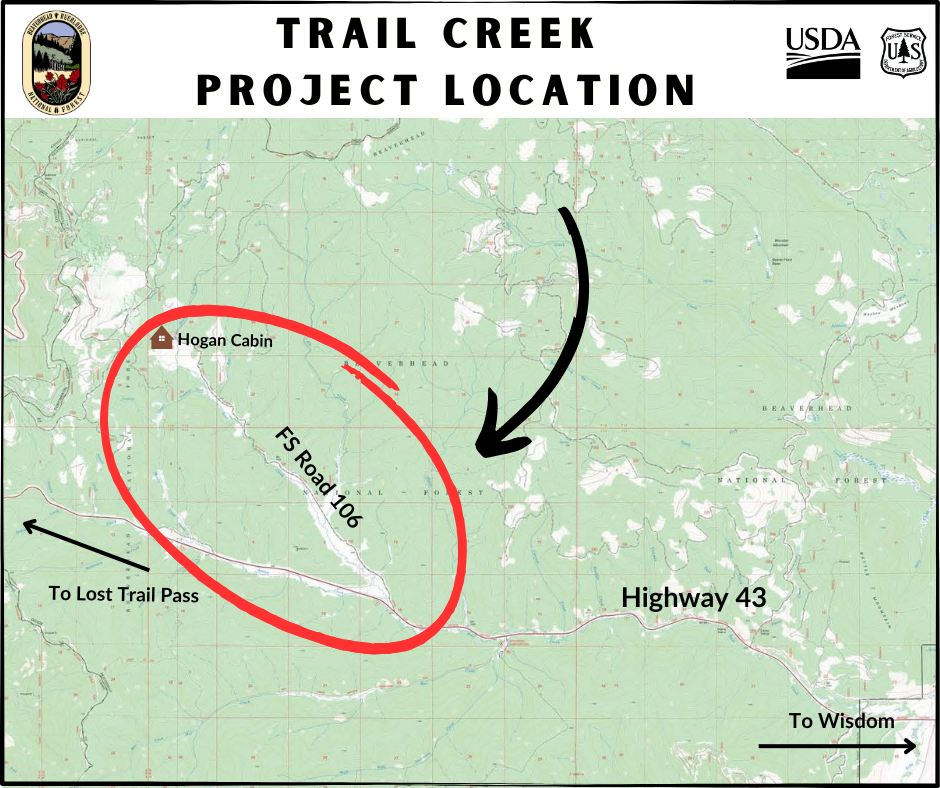
Trail Creek - 17 miles west of Wisdom, along Hwy 43 on Trail Creek Road 106
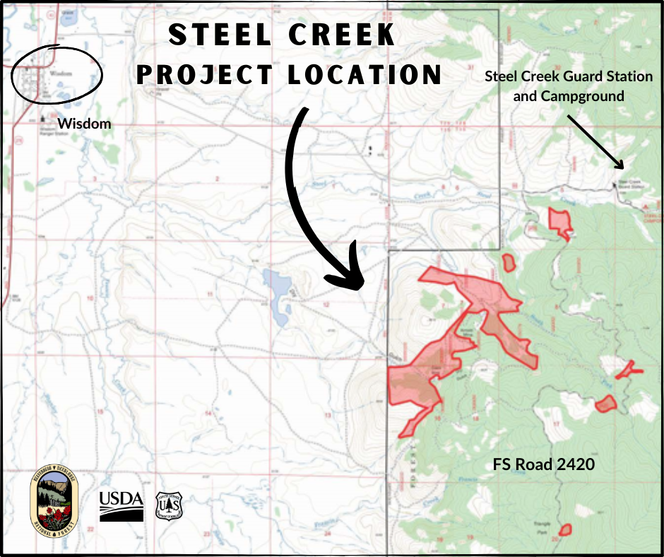
Steel Creek - 2 miles east of Wisdom
Dillon Ranger District Rx Fire Operations Spring 2025 03 28 2025
Related Incident: Beaverhead-Deerlodge NF Prescribed Fire Operations
Publication Type: Announcement
The Dillon Ranger District has developed prescribed fire implementation plans for the following units:
French Creek - 4 miles northwest of Argenta
Middle Fork Little Sheep Creek - 10 miles southwest of Lima
Butte Ranger District Rx Fire Operations Spring 2025 03 28 2025
Related Incident: Beaverhead-Deerlodge NF Prescribed Fire Operations
Publication Type: Announcement
The Butte Ranger District has developed prescribed fire implementation plans for the following units:
Red Rocks - 1 mile west of the Bernice exit on I-15, between Butte and Boulder, MT.
Fleecer - 3 miles west of the Feely exit on I-15, south of Rocker, MT.
Big Ridge Fire Update March 28 03 28 2025
Related Incident: Big Ridge Fire
Publication Type: News
Highlights: Today at 6 a.m. the Southern Area Gold Complex Incident Management Team assumed management of the Big Ridge Fire under the leadership of Incident Commander Paul Varnedoe. The Gold Team expresses its appreciation to the Forest Type 3 Team, Rabun Couty Sheriff’s Office, cooperators, collaborators and the community for their support to the firefighters. Firelines on the north side of the fire continued to hold Thursday and there was growth to the south and east. A virtual public meeting will be held in Sky Valley Saturday with details to follow.
Fire Activity: Today firefighters will focus holding the north line from Rabun Bald to Wilson Knob to keep the fire from Sky Valley. Crews will continue constructing direct line from Wilson Knob to south to Walnut Fork. On the southeast side of the fire line is being constructed from Sara’s Creek to Hale Ridge Road, which will serve as the eastern primary control line. On the north, line is being constructed from Beegum Gap to Hale Ridge Road following Holcomb Creek. Firefighters are also scouting and constructing secondary control lines in case these primary control lines are compromised.
The U.S. Forest Service Law Enforcement and Investigations is seeking information regarding the circumstances around the cause of the Big Ridge Fire. If anyone was in the area on March 22, 2025, and observed suspicious activity please call the Georgia Forestry Commission Arson Hotline 1-800-428-7337.
Weather: A Red Flag Waring is in effect today for critical fire danger. Today’s forecast calls for 72 degrees and minimum relative humidity of 19%. Winds will be southwest with sustained speeds of 10 mph and gusts of 23 mph. Temperatures and wind will increase early Saturday ahead of a change to higher humidity and possible rainfall after dark on Saturday into Sunday morning.
Evacuations: None.
Closures: Visit https://inciweb.wildfire.gov/incident-closures/gachf-big-ridge-fire
More Information:
Facebook: https://www.facebook.com/ChattOconeeNF
Email: 2025.BigRidge@firenet.gov
Fire Information: 770-530-3950
Inciweb: https://inciweb.wildfire.gov/incident-information/gachf-big-ridge-fire