
Hurst Fire Morning Update 01 08 2025
Related Incident:
Publication Type: News
Start Date: Tuesday, January 7th, 2025, at 10:25 p.m.
Location: near the I-210 Freeway and Yarnell St. in Sylmar, CA
Unified Command: Angeles National Forest, Los Angeles County Fire, Los Angele Fire Department, Los Angeles County Sheriff, CAL FIRE
Fire Size: 505 acres
Percent Contained: 0%
Personnel: 250
Cause: Under investigation
CURRENT SITUATION:
On Tuesday, January 7th, 2025, at 10:25 p.m. firefighters responded to a brush fire reported near the 210 Freeway and Yarnell St. in Sylmar, CA. Overnight firefighters fought aggressively and were challenged by extreme weather and fire behavior. Today crews will be focusing on establishing control lines along the 210 Freeway north of the Santa Clara Divide Road. They will also continue reinforcing control lines behind structures along Foothill Boulevard and the 210 Freeway.
A red flag warning remains in effect for the area until 6:00 p.m. Thursday. A high wind watch is in effect until 6:00 p.m. this evening. The Los Angeles Fire Department is in unified command with the Angeles National Forest, Los Angeles County Fire Department, Los Angeles County Sheriff, and CAL FIRE.
Evacuation Map: For the most up-to-date Evacuation information visit Protect Genasys using the link: https://protect.genasys.com/zones/US-CA-XLA-PAS-E019?z=14.003579616721366&latlon=34.16776191835291%2C-118.08215038964448
Road Closures:
Fire Information:
InciWeb Website: https://inciweb.wildfire.gov/incident-information/caanf-hurst-fire
Angeles National Forest: https://www.fs.usda.gov/angeles
Horton Fire Daily Update 01 08 2025
Related Incident: Horton Fire 2024
Publication Type: News
Cold weather event reduces fire behavior; Containment continues to increase.
Daily Update: January 8, 2025
Acres: 8,337
Containment: 23%
Start Date: December 14, 2024
Location: Payson Ranger District, Arizona
Cause: Under Investigation
Personnel: 525
Fuels: Timber, chaparral
Resources: 8 crews | 32 engines | 3 helicopters | 1 bulldozers | 4 water tenders
Highlights: Today’s change in the weather has brought colder temperatures and higher winds into the area. This incoming weather has diminished fire activity, and fire crews are continuing full suppression strategies on the Horton Fire. Yesterday and overnight, firefighters addressed unburned areas on the interior of the fire while also holding and patrolling the edge of the fire, especially along the western edge and the SR-260 corridor.
Smoke: Smoke and flames continue to be visible in the area. Visibility may be poor at times. For more information on local smoke impacts, visit https://outlooks.wildlandfiresmoke.net/outlook/.
Operations: Fire crews will continue patrolling and monitoring the western and southern edges of the fire while also scouting the fire perimeter on the northern and eastern edges today. Work will continue in the interior of the fire, addressing unburned pockets of fuels and hazardous areas where it is safe and appropriate to do so. For this next operational period, firefighters are scouting and preparing the northern and eastern edges of the fire as this cold weather system moves through the area.
Weather: It will be cold today, with average temperatures in the area rising to the mid-20s. Winds are also expected to increase out of the northeast at 18-22 mph and gusting to 35 mph. There is a minimal chance of precipitation. Fire behavior is expected to diminish with this colder weather and possible precipitation, but it is not expected to extinguish the fire.
TFR: A Temporary Flight Restriction (TFR 5/0461) is in place for the Horton Fire through January 31. More information is available at https://tfr.faa.gov/save_pages/detail_5_0461.html.
Evacuations, Road Closures and Forest Orders: The communities of Christopher Creek, Hunter Creek, R-C Scout Camp, Tonto Creek Estates, Tonto Christian Camp, Tonto Fish Hatchery, Kohls Ranch, and Zane Grey Cabins are in SET evacuation status. The health and safety of firefighters and the public are always the priority. Members of the public are asked to avoid the area. Visit https://www.facebook.com/GCPHCS/ for more information on evacuation notifications.
Temporary lane closures are occurring on SR-260 due to smoke from the Horton Fire. Travelers are encouraged to monitor roadway status and conditions via AZ Department of Transportation at https://www.az511.com/.
A Forest closure order is in effect to protect public health and safety during the Horton Fire as well as protecting firefighting personnel engaging in wildland firefighting operations. More information can be found at https://www.fs.usda.gov/alerts/tonto/alerts-notices.
Settings - change map background and toggle additional layers
Filter - control incident types displayed on map.
Zoom to your location
Reset map zoom and position
Could not determine your location.
Show Legend
 Wildfire
 Prescribed Fire
 Burned Area
Response
Burned Area
Response Other
Other
Eaton Fire
Unit Information
Incident Contacts
Horton Fire Daily Update 01 07 2025
Related Incident: Horton Fire 2024
Publication Type: News
Horton Fire reaches SR-260 after successful firing operations; Containment increases.
Daily Update: January 7, 2025
Size: 7,032
Cause: Under Investigation
Containment: 19%
Start Date: December 14, 2024
Location: Payson Ranger District, Arizona
Fuels: Ponderosa pine, mixed conifer, chaparral
Resources: 8 crews | 32 engines | 3 helicopters | 1 bulldozers | 4 water tenders
Highlights: It was a successful 24 hours on the Horton Fire, with ground and aerial fire crews implementing firing operations along the side of the Mogollon Rim, from Horton Creek to Christopher Creek. The Horton Fire is now down to the SR-260 corridor between those two drainages, a significant step in the full suppression strategy of securing the Horton Fire on its western and southern edges. Firefighters will work today on securing and patrolling the fire prior to incoming weather changes.
Smoke: Smoke and flames continue to be visible in the area and can be seen from State Route 260. Visibility may be poor at times, especially in the late evening and early morning with current temperatures and inversions. For more information on local smoke impacts, visit https://outlooks.wildlandfiresmoke.net/outlook/.
Operations: Crews will continue working on securing and monitor the fireline while mitigating hazards today, ahead of predicted weather changes and increasing winds. With this shift in the weather, ground and aerial resources are expected to transition from active firing operations to patrolling and monitoring the Horton Fire during the weather event. Crews will still be working on the fire on both day and night shifts, including structure protection crews in local neighborhoods such as Tonto Estates and Christopher Creek.
Weather: Temperatures will range from mid-30s to low-40s with winds at 12-20mph, gusting from 25-30mph, and relative humidity up to 30%. There is a potential for traces of precipitation today, which could become light showers or flurries depending on temperatures this afternoon. Members of the public are encouraged to practice additional caution today, as roads may become icy.
TFR: A Temporary Flight Restriction (TFR 5/0461) is in place for the Horton Fire through January 31. More information is available at https://tfr.faa.gov/save_pages/detail_5_0461.html.
Evacuations, Road Closures and Forest Orders: The communities of Christopher Creek, Hunter Creek, R-C Scout Camp, Tonto Creek Estates, Tonto Christian Camp, Tonto Fish Hatchery, Kohls Ranch, and Zane Grey Cabins are in SET evacuation status. The health and safety of firefighters and the public are always the priority. Members of the public are asked to avoid the area.
Temporary lane closures are occurring due to the Horton Fire when reduced visibility due to smoke occurs on SR-260. Travelers are encouraged to monitor roadway status and conditions via AZ Department of Transportation at https://www.az511.com/.
A Forest closure order is in effect to protect public health and safety during the Horton Fire as well as protecting firefighting personnel engaging in wildland firefighting operations. More information can be found at https://www.fs.usda.gov/alerts/tonto/alerts-notices.
Settings - change map background and toggle additional layers
Filter - control incident types displayed on map.
Zoom to your location
Reset map zoom and position
Could not determine your location.
Show Legend
- Wildfire
- Prescribed Fire
- Burned Area
Response
- Other
Hill Unit Pile Burn - Jemez Ranger District
Unit Information
Incident Contacts
Current Pile Burning Activity 01 08 2025
Related Incident: Arapaho and Roosevelt National Forests Pile Burning
Publication Type: Announcement
Larimer County, Canyon Lakes Ranger District - Week of Jan 7 to Jan 13, 2025
Fire managers plan to burn piles on Canyon Lakes Ranger District starting as early as tomorrow, Tuesday, Jan 7, if conditions allow. The potential units planned for this week is as follows:
Cow Creek: Machine piles. 4 miles west of Crystal Lakes subdivision at the intersection of FSR 169 (Pearl Beaver Road) and FSR 199.
Elkhorn 3: Machine Piles. 3 miles southwest of Red Feather Lakes and west along FSR 517 (Bald Mountain Road).
Pierson Park: Hand piles. 3.5 miles southeast of Estes Park along Pierson Park Road and Johnny Park Road. (likely delayed to next week)
Boulder and Gilpin Counties, Boulder Ranger District - Week of Jan 7 to Jan 13, 2025
Fire managers are monitoring conditions to burn piles in Boulder Ranger District, with the next possible ignitions window starting on Wednesday, January 8, in the following Boulder and Gilpin County locations:
Forsythe II Unit 44: Hand piles west of Gross Reservoir, 2 miles north of Wondervu and .5 miles south of Lazy Z.
Lump Gulch Units 27 & 37: Hand piles ½ mile north of Highway 119 and South Beaver Creek Road intersection, near Pine Drive
Lump Gulch Unit 35: Hand piles 2 miles south of Rollinsville on the west side of Highway 119.
Lump Gulch Unit 18: Hand piles .5 miles north of Rollinsville on the west side of Highway 119.
Lump Gulch Unit 38: Hand piles off of South Beaver Creek Road on the south side. 1 miles northeast of Highway 119 and the South Beaver Creek Road intersection.
Jefferson County, Clear Creek Ranger District - Week of Jan 7 to Jan 13, 2025
Fire managers are monitoring conditions to burn piles in Clear Creek Ranger District, with the next possible ignitions window starting on Wednesday, January 8, in the following Jefferson County location:
Evergreen: Hand piles Cub Creek Trailhead, 5 miles southwest of Evergreen.
Horton Fire Daily Update 01 06 2025
Related Incident: Horton Fire 2024
Publication Type: News
Acreage increases as fire grows towards handlines and control features; Public meeting tonight
Daily Update: January 6, 2025
Size: 3,598 acres
Cause: Under Investigation
Containment: 17%
Total personnel: 457
Start Date: December 14, 2024
Location: Payson Ranger District, Arizona
Fuels: Ponderosa pine, mixed conifer, chaparral
Resources: 8 crews | 32 engines | 3 helicopters | 1 bulldozer | 4 water tenders
Highlights: Firefighters were successful yesterday and last night in bringing the fire off the rim and closer to established control lines north of SR-260, east of Horton Creek, and west of Christopher Creek. With today’s predicted favorable weather conditions and as part of the full suppression tactics for the Horton Fire, crews plan on continuing strategic burning operations to secure the fire perimeter near neighborhoods and along SR-260.
A public meeting is scheduled for 6 p.m. tonight, at The Church of Jesus Christ of Latter-Day Saints, located at 546 W Ashby Apple Dr., Payson, AZ 85541. Livestream available on the Tonto National Forest Facebook page.
Smoke: Smoke and flames continue to be visible in surrounding areas and from SR- 260. For more information on local smoke impacts, visit https://outlooks.wildlandfiresmoke.net/outlook/.
Operations: Crews will continue work around Promontory Point today and tonight. On the western side, crews continue strengthening the control line along the Horton Creek Trail and in the Tonto Creek Estates area. On the eastern side, crews are working in the Christopher Creek area, bringing fire along ridgelines for increased protection of the Christopher Creek neighborhood. Aviation resources, both helicopters and drones, are working in between these two drainages to help remove ground fuels and move this fire as safely and securely as possible through the forested areas.
Weather: For the Horton Fire area, temperatures will rise a few degrees in the afternoon compared to Sunday. This warming will work to bring down humidity. Winds will be generally light, favoring terrain influences for its direction. Moisture will improve modestly overnight as the next weather system begins. A strong inversion will set up tonight which in the presence of light winds and better humidity may create visibility impacts.
TFR: A Temporary Flight Restriction (TFR 5/0461) is in place for the Horton Fire through January 31. More information is available at https://tfr.faa.gov/save_pages/detail_5_0461.html.
Evacuations, Road Closures and Forest Orders: The communities of Christopher Creek, Hunter Creek, R-C Scout Camp, Tonto Creek Estates, Tonto Christian Camp, Tonto Fish Hatchery, Kohls Ranch, and Zane Grey Cabins are in SET evacuation status. Highway closures are not currently in effect due to the Horton Fire, however reduced visibility due to smoke on SR-260 is possible. The health and safety of firefighters and the public are always the priority. Members of the public are asked to avoid the area. Travelers should monitor roadway status and conditions via AZ Department of Transportation at https://www.az511.com/.
A Forest closure order is in effect to protect public health and safety during the Horton Fire as well as protecting firefighting personnel engaging in wildland firefighting operations. More information can be found at https://www.fs.usda.gov/alerts/tonto/alerts-notices.
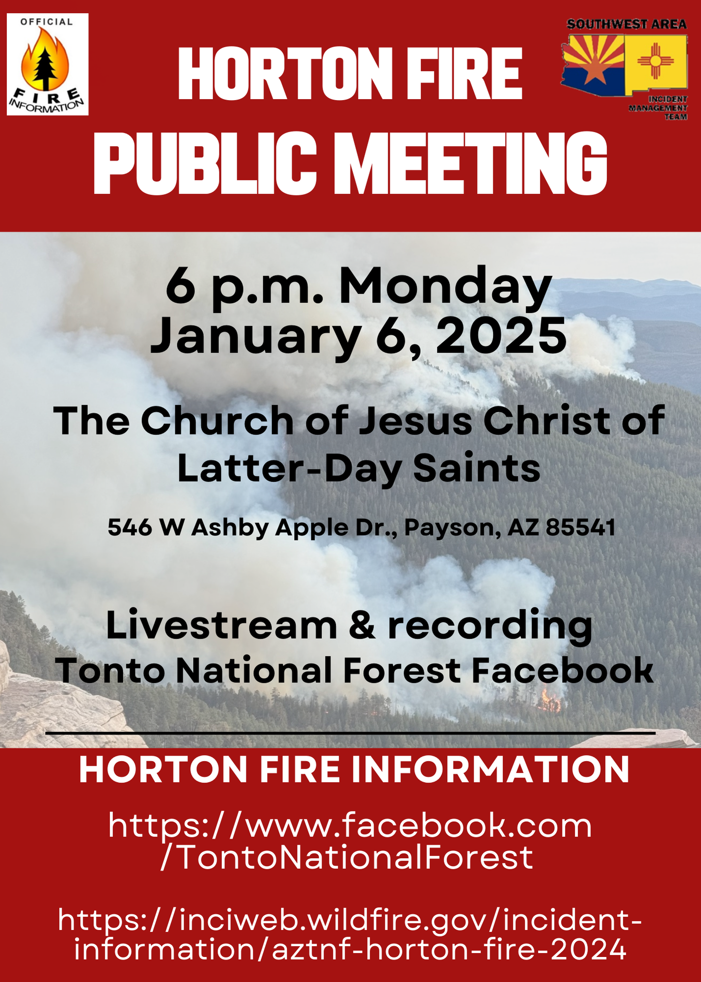
Horton Fire public meeting scheduled for January 6 2025 01 05 2025
Related Incident: Horton Fire 2024
Publication Type: Announcement
A public meeting is scheduled for 6 p.m. on Monday, January 6, 2025, at The Church of Jesus Christ of Latter-Day Saints, located at 546 W Ashby Apple Dr., Payson, AZ 85541. This meeting will also be livestreamed on the Tonto National Forest Facebook page at https://www.facebook.com/TontoNationalForest. A recording will be available.
Horton Fire Daily Update 01 05 2025
Related Incident: Horton Fire 2024
Publication Type: News
Firing operations underway to protect communities near Horton Fire; Smoke impacts expected
Daily Update: January 5, 2025
Size: 1,972 acres
Cause: Under Investigation
Containment: 17%
Total personnel: 416
Start Date: December 14, 2024
Location: Payson Ranger District, Arizona
Fuels: Ponderosa pine, mixed conifer, chaparral
Resources: 7 crews | 32 engines | 2 helicopters | 1 bulldozer | 4 water tenders
Highlights: Firefighters had a successful day of firing operations and fireline enhancement yesterday and last night. Today, work will continue around Promontory Point, with ongoing ignitions below the rim between Horton Creek Trail and eastward towards Christopher Creek as work continues on this full suppression fire.
A public meeting is scheduled for 6 p.m. on Monday, January 6, 2025, at The Church of Jesus Christ of Latter-Day Saints, located at 546 W Ashby Apple Dr., Payson, AZ 85541. This meeting will also be livestreamed on the Tonto National Forest Facebook page.
Smoke: Smoke and flames continue to be visible in the area and can be seen from State Route 260. For more information on local smoke impacts, visit https://outlooks.wildlandfiresmoke.net/outlook/.
Operations: Firefighters continue working on both day and night shifts on the Horton Fire. Yesterday, winds limited aerial firing operations above the rim. Heavy equipment successfully constructed dozer line on the north end of the fire, tying into existing handline and further securing containment features. Today, crews will conduct firing operations along the Mogollon Rim, on the Horton Creek Trail east of the community of Tonto Creek Estates and west/north of Christopher Creek to assist with reducing fuel availability and help control the main fire’s spread. Crews will continue patrolling and securing fireline as structure protection resources lay hose and conduct point protection in nearby communities.
Weather: The fire area is forecasted to experience temperatures from the high-40s to low-50s with relative humidity up to 60% and calmer winds. No precipitation is expected in the next 24-48 hours.
TFR: A Temporary Flight Restriction (TFR 5/0461) is in place for the Horton Fire through January 31. More information is available at https://tfr.faa.gov/save_pages/detail_5_0461.html.
Evacuations, Road Closures and Forest Orders: The communities of Tonto Creek Estates, Tonto Christian Camp, Tonto Fish Hatchery, Kohls Ranch, and Zane Grey Cabins are in SET evacuation status. The health and safety of firefighters and the public are always the priority. Members of the public are asked to avoid the area.
Highway closures are not currently in effect due to the Horton Fire, however reduced visibility due to smoke on SR-260 is possible. Travelers should monitor roadway status and conditions via AZ Department of Transportation at https://www.az511.com/.
A Forest closure order is in effect to protect public health and safety during the Horton Fire as well as protecting firefighting personnel engaging in wildland firefighting operations. More information can be found at https://www.fs.usda.gov/alerts/tonto/alerts-notices.
Information Links and Contacts:
Tonto National Forest https://www.fs.usda.gov/tonto
InciWeb https://inciweb.wildfire.gov/incident-information/aztnf-horton-fire-2024
Fire Email 2024.horton@firenet.gov
Fire Information Line (602)-551-7327 • Office Hours: 8 a.m. – 8 p.m.
Horton Fire Daily Update 01 04 2025
Related Incident: Horton Fire 2024
Publication Type: News
Firing operations continue, creating a potential increase of smoke impacts to the area.
Daily Update: January 4, 2025
Size: 1,890 acres
Cause: Under Investigation
Containment: 17%
Total personnel: 418
Start Date: December 14, 2024
Location: Payson Ranger District, Arizona
Fuels: Ponderosa pine, mixed conifer, chaparral
Resources: 7 crews | 32 engines | 2 helicopters | 1 bulldozer | 4 water tenders
Highlights: With the Horton Fire moving down off the Mogollon Rim and onto the face, in addition to continued firing operations, there is increased visible smoke and flames along the top of the rim which can be seen from State Highway 260. For more information on local smoke impacts, visit https://outlooks.wildlandfiresmoke.net/outlook/.
Operations: Firefighters will continue working below the Mogollon Rim and along the Horton Creek Trail today, enhancing control features by removing available fuels with the use of hand tools and planned ignitions, from both the ground and the air, as conditions allow. Air resources may be less available today due to forecasted increasing and sporadic winds, especially on top of the rim. The fire is expected to continue moving south and off the face of the rim, and into the head of Horton Creek. Firefighters are working around the clock in this area to secure the fire line in this steep and difficult terrain. Structure protection resources laid over 7,000 feet of hose yesterday near the areas of Tonto Creek Estates and Christopher Creek. As additional incident personnel continue to arrive, the public is reminded to please practice caution when traveling in the area.
TFR: A Temporary Flight Restriction (TFR 4/0101) is in place for the Horton Fire. More information is available at https://tfr.faa.gov/save_pages/detail_4_0101.html
Weather: The fire area is forecasted to experience temperatures from the low-30s to mid-50s with relative humidity around 16-25%. SW Winds will increase with localized gusts of 20-30 mph across the Rim. No precipitation is expected in the next 48 hours.
Evacuations, Road Closures and Forest Orders: The communities of Tonto Creek Estates, Tonto Christian Camp, Tonto Fish Hatchery, Kohls Ranch, and Zane Grey Cabins are in SET evacuation status. The health and safety of firefighters and the public are always the priority. Members of the public are asked to avoid the fire area.
Highway closures are not currently in effect due to the Horton Fire, however reduced visibility due to smoke on SR-260 is possible. Travelers are encouraged to monitor roadway status and conditions via AZ Department of Transportation at https://www.az511.com/. A Forest closure order for the Horton Fire is in effect. The purpose of the closure order is to protect public health and safety during the Horton Fire as well as protecting assigned firefighting personnel engaging in wildland firefighting operations. Learn more at https://www.fs.usda.gov/alerts/tonto/alerts-notices.
Information Links and Contacts:
Tonto National Forest https://www.fs.usda.gov/tonto
InciWeb https://inciweb.wildfire.gov/incident-information/aztnf-horton-fire-2024
Fire Email 2024.horton@firenet.gov
Fire Information Line (602)-551-7327 • Office Hours: 8 a.m. – 8 p.m.