
Rush Fire Smoke Outlook 10 31 2024
Related Incident:
Publication Type: News
Rush Fire Smoke Outlook for October 31- November 1, 2024
FIRE
The Rush Fire fire is currently estimated at 12488 acres and is 61% contained. Fire activity for the Rush Fire fire is expected to remain low.
SMOKE
Temperature will stay in the 70's today with Winds this morning out of the north 9-19 mph switching to NNE 11 mph with some gust upward of 18 mph. The winds will be out of the NE - ENE this evening 4-5 mph switching out of the East 5-mph with some gusts 8-15 mph. With overnight light rains on the fire, we may see some light smoke on smoldering heavy fuels. GOOD air quality to continue today within the forecast area.
HEALTH STATEMENT
Smoke can be harmful to your health. Check with your doctor if there are any health concerns and monitor your local air quality conditions using the Fire and Smoke Map.
AIR
October 31 2024 Pile Burn Update 10 31 2024
Related Incident:
Publication Type: News
Pile burning will continue today across the Lolo National Forest. Pile burning reduces the amount of fuels that are available to burn, lowering a wildfire’s intensity and reducing risks to firefighters and communities, a key component of the Wildfire Crisis Strategy.
Missoula Ranger District: Firefighters will conduct approximately 40 acres of pile burning on the Missoula Ranger District. Pending conditions, the pile burning will take place 3.5 miles northwest of Lolo Hot Springs off Forest Road 33 at the junction of Wagon Mountain Road and Howard Creek Road. Smoke may be visible from Highway 12 and Lolo Hot Springs.
Plains/Thompson Falls Ranger District: The Plains/Thompson Falls District will conduct pile burning at the Plains Ranger District. Smoke may be visible from Plains.
Superior Ranger District: Firefighters on the Superior District will conduct up to 35 acres of pile burning on the Hall Wood Timber Sale project located 5 miles northeast of Superior. Smoke may be visible from Superior and Interstate 90.
Front Country Prescribed Fire Closure Order 24001 10 30 2024
Related Incident: Front Country Prescribed Fire
Publication Type: Closures
United States Department of the Interior
NATIONAL PARK SERVICE
Rocky Mountain National Park
Estes Park, Colorado 80517
10D ROMO-VRP
Closure Order #24-001
11/01/2024
Closures, restrictions, and public use limits:
Closure Order – Portions of park area: Under the authority provided to the Superintendent in 36 CFR 1.5, the following areas administered by the National Park Service within Rocky Mountain National Park are closed, effective immediately, until further notice, due to a prescribed burn. The following park areas are closed:
- Specific geographic location for the closure includes an area west of Beaver Meadows Visitors Center (BMVC) and south of U.S. Highway 36, with the western terminus being at the intersection of U.S. Highway 36 and Bear Lake Road. The southern terminus of this closure will extend to Beaver Brook Creek.
Authority: 36 CFR 1.5(a)(1)
Notice: This administrative order applies to all individuals subject to the regulatory authority of the National Park Service (NPS) within the boundaries of Rocky Mountain National Park, including park visitors, government employees, concession employees, park residents and stakeholders, except as follows:
- Government Employees carrying out their official duties.
Finding: The NPS issues this administrative order for the purposes of maintaining public health and safety due to a prescribed burn.
These directives require the NPS to take the actions identified above because:
- This closure is necessary for the maintenance of public safety, and the implementation of management responsibilities, to include rehabilitation of affected areas.
This order is effective immediately and will remain in effect until further notice. The effectiveness of this order will be assessed on an ongoing basis, and the order will be modified or rescinded when conditions warrant.
Approval: /s/ Jay Shields, Acting Superintendent, 10/29/2024
Landowner Resources Flyer 10 30 2024
Related Incident: Elk Fire 2024
Publication Type: Announcement
State and Federal resources for landowners affected by wildfire are available. Please take a look at this flyer for more information, and contact one of the representatives for more information.
Rocky Mountain National Park announces plans for prescribed burn this Friday and Saturday if conditions allow 10 30 2024
Related Incident: Front Country Prescribed Fire
Publication Type: News
October 30, 2024
For Immediate Release
Kyle Patterson 970-586-1363
Rocky Mountain National Park announces plans for prescribed burn this Friday and Saturday, if conditions allow
Based upon the potential for favorable weather and fuels conditions, fire managers at Rocky Mountain National Park are planning to conduct a prescribed burn beginning on Friday, November 1, 2024. Firefighters plan to burn approximately 100 acres of the 334-acre Headquarters Unit on Friday, November 1 and Saturday, November 2. This burn unit is located inside Rocky Mountain National Park, west of the Beaver Meadows Visitor Center and south of U.S. Highway 36. Because of the fuel type that will be burned, which include mainly grasses, heavy and prolonged smoke is not expected from this operation.
The primary goal of the project is to reduce the threat of wildland fire to adjacent communities and NPS infrastructure by using prescribed fire to reduce the amount of fuels available in this area. When fighting the East Troublesome Fire in 2020 and the Fern Lake Fire in 2012, firefighters were able to take advantage of previous and existing prescribed fire and hazardous fuels treatment areas that provided a buffer between the fires and the town of Estes Park. Prior hazard fuels projects were instrumental in stopping both fires from crossing Bear Lake and Trail Ridge Roads.
If conditions are favorable, ignitions are planned to occur on Friday, November 1 and Saturday, November 2. Firefighters will be on scene for the duration of the operation and will be patrolling the burned area overnight after operations conclude each day. Smoke from the prescribed burn will be visible throughout the day of the burn, mostly during the warmest part of the day. With cooler temperatures in the evening, smoke may linger and accumulate in low-lying areas.
Fire operations near the Beaver Meadows Entrance to RMNP may cause brief delays or divert outbound traffic through Fall River Entrance. Motorists should watch for fire vehicles on the roads and allow extra time for entering and exiting the park. Traffic control will be in place on U.S. Highway 36 within the burn area. Additional information will be shared on InciWeb and on RMNP’s official social media channels. NPS Fire Information Officers will be available at Beaver Meadows Visitor Center to answer questions.
For the safety of visitors and firefighters, park visitors will not be allowed to stop along U.S. Highway 36 within the burn area. Visitors will also not be able to walk within the burn area.
Smoke may be visible both inside and outside the park. Every effort will be made to minimize smoke impacts on visitors and the adjacent community; however, some smoke is anticipated to disperse east of the park. Smoke may affect your health: For more information see https://www.colorado.gov/pacific/cdphe/wood-smoke-and-health.
Safety factors, weather conditions, air quality, personnel availability and environmental regulations are continually monitored as part of any fire management operation. For more information please contact the park Information Office at (970) 586-1206.
- NPS -
BDNF FallWinter Planned Pile Burning 10 30 2024
Related Incident: Beaverhead-Deerlodge NF Prescribed Fire Operations
Publication Type: News
Fall Pile Burning Projects Planned
on the Beaverhead-Deerlodge National Forest
The Beaverhead-Deerlodge National Forest may implement prescribed fire pile burning projects this fall/winter, as weather and fuels conditions allow. Prescribed fire and pile burning activities are highly weather dependent, relying on close coordination with the National Weather Service and air quality specialists to determine the best possible weather conditions to promote smoke dispersal and limit smoke impacts.
The Forest has developed pile burning plans for the following units for the respective Ranger Districts. Maps of the specific units can be found under the "Announcements" tab in the Inciweb site.
Black Mountain piles - 12 miles south of Jackson on Forest Service Road 919
Harrison Park Trailhead piles - 10 miles north of Polaris on Pioneer Mountains Scenic Byway
Middle Fork Little Sheep Creek piles - 10 miles southwest of Lima
Pintler Face piles (Calvert Creek) - northwest of Wisdom on the 1223 road in Calvert Creek
Pintler Face piles (Seymour Creek) - west of Mill Creek Highway 274 on Forest Service Road 934
Steele Creek piles - 6 miles east of Wisdom on road 2420, from South Fork to Triangle Park area
Calvert Hill piles - 19 miles northeast of Wisdom, along Forest Service Road 70648
Pettengill Creek piles - south of Wise River, along Pioneer Mountains Scenic Byway, at Stine Creek and Sheep Creek
Trail Creek piles- 20 miles west of Wisdom, along Forest Service Road 106 off Highway 43.
Basin Creek piles - Basin Creek watershed, 10 miles south of Butte
Red Rocks piles - north of the Bernice exit off I-15, 22 miles north of Butte
Johnny Gulch piles - 20 miles south of Ennis along Forest Service Road 324
Bowles piles - 22 miles southwest of Philipsburg, south of MT Hwy 83 near Skalkaho Pass area
Upper Willow piles - 16 miles northwest of Philipsburg, along county road 88
EDLV piles - 10 miles northeast of Opportunity, east of Interstate 90 between Galen and Warm Springs exits
Hand piles - smaller hand piles located at Georgetown Lake, East Fork Reservoir, Middle Fork of Rock Creek, Stony Creek, and Henderson Mountain
Why burn piles? Pile burning operations help reduce accumulations of fuels from previous projects or fire incidents, increasing landscape wildfire resilience and reducing the risk of uncharacteristic wildfire effects on the landscape.
Public notifications: Prior to initiating the prescribed fire or pile burning operations, fire professionals assess conditions, conduct a test burn, and notify local governments and interested publics via website postings, email, social media, and news releases. Implementation and accomplishment updates will also be posted to the Forest website, the Prescribed Fires Inciweb page, and the Forest’s Wildland Fire Information Facebook page.
Smoke: Minimal smoke impacts are expected with pile burning operations. Larger piles will normally consume completely in a few days, with smaller hand piles taking less time. Smoke may be visible from adjacent communities and roadways. Smoke tends to pool in lower elevations and along roadways during the evenings and early morning hours, so motorists should take note during those times.
Contact the B-D Forest Fire PIO, Terina Hill, at (406) 683-3920, or the B-D Fuels Program Manager, Greg Schenk, at (406) 683-3870, for additional information.
Shoe Fire Daily Update for 10 30 2024
Related Incident: Shoe Fire
Publication Type: News
SHOE FIRE
DAILY UPDATE
October 30, 2024
Email: 2024.shoe@firenet.gov
Incident Website: https://inciweb.wildfire.gov/incident-information/cashf-shoe-fire
Forest Website: https://www.fs.usda.gov/stnf
Fire Weather Forecast: https://www.weather.gov/wrh/CAFW?area=ECC005
Fire Information Line: 530-338-0317 (Staffed 8:00 AM – 8:00 PM)
Quick Facts:
Location: Shasta County, CA │ Start Date: Wednesday, October 9, 2024, at 6:57 PM │ Cause: Human
Size: 5,124 │ Containment: 80%│ Vegetation: Timber, Chapparal │ Total Personnel Assigned: 599
Firefighters took advantage of the sunny, dry weather yesterday, engaging in fire suppression repair tasks and patrolling for smokes that could appear due to breezy conditions. Yesterday afternoon, firefighters spotted a smoke that appeared to be a new fire start within the vicinity. A helicopter reconnaissance mission determined the drifting smoke was from a local prescribed burn. Additional water handling equipment, pumps, and portable tanks were backhauled from the fire yesterday to be returned to the North Zone fire cache for refurbishment and reuse. Excavators completed suppression repairs on control lines along Garden Ridge and continue to repair dozer lines in other areas of the fire. Chipping was completed in a few areas to the south and west of the fire and continues along Forest Service Road 38N07. Excavators are moving into areas where chipping has already occurred to install water bars and clean out culverts to ensure adequate drainage. Masticators and graders are working along Fenders Ferry Road and an excavator is repairing control line towards Blue Jay Mountain. Firefighters with heavy equipment are also progressing with fire suppression repairs along Curl Ridge.
WEATHER: The ridge of high pressure over the region will quickly shift east and out of the region. This will allow a vigorous low-pressure system to move into the region Wednesday afternoon bringing what appears to be the first significant winter storm of the season. Temperatures will be cooler than normal with highs mainly in the 40s. Relative humidity will stay well above seasonal averages. Precipitation will show up as showers, with some of these showers being very intense at times. Rain amounts will range from one inch to over two inches from Wednesday night through Saturday morning.
CLOSURES AND SAFETY:
- Fenders Ferry Road at Pit River 7 Bridge: West-Bound Fenders Ferry Road (Also known as 34N17 - Forest Service Road 27) at the Pit River Bridge/Pit 7
- Ferry Road is closed at McCloud Bridge: East-Bound Fenders Ferry Road at the McCloud River Bridge
- A Temporary Flight Restriction is in place over the fire area https://tfr.faa.gov/save_pages/detail_4_2632.html. Drones are prohibited from flying in fire areas. If you fly, we can’t.
- A temporary Forest closure is in effect https://www.fs.usda.gov/detailfull/stnf/alerts-notices/?cid=stelprdb5392380
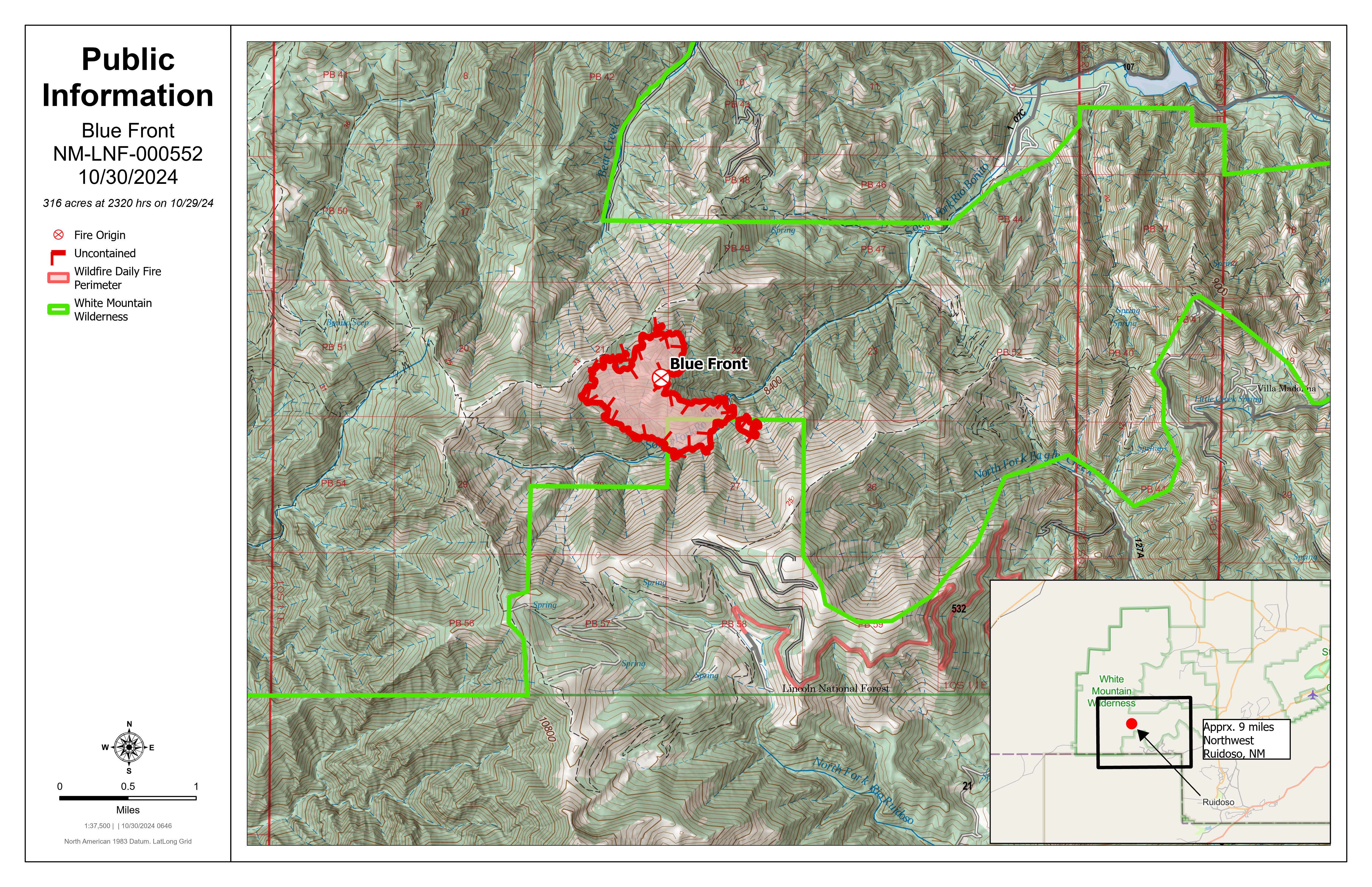
Blue Front Fire Morning Update 10 30 2024
Related Incident: Blue Front Fire
Publication Type: News
Blue Front Fire Morning Update, October 30, 2024
Start Date / Time: October 28, 2024
Cause: Unknown
Size: 316 acres
Location: 4 miles west of Alto, 9 miles northwest of Ruidoso, located in the Blue 2 wildfire footprint in the White Mountain Wilderness.
Resources: Smokey Bear Hotshot Module and Sacramento Hotshot Module, Engine 612 (Type 6), Engine 311 (Type 3), Type 1 helicopter, incoming Type 3 crews and resources arriving
Types of vegetation in the area (aka fuels): Grass, shrubs, dead/down fuels
Containment: 0% Strategy: Full Suppression Road Closures: None Smoke: Light
Update: Yesterday, high wind speeds and gusts, along with warmer temperatures resulted in fire spread through grass and dead/down fuels throughout the wildfire footprint. Aviation assets were grounded due to high winds. Crews worked on the ground to establish containment lines, remaining overnight.
Today, more resources for a Type 3 organization will continue to arrive on-scene and begin work in the area. Crews will focus on an 8-acre spot that crossed the South Fork Trail, and the South Fork Drainage Area. Air support will continue to be utilized as conditions allow.
Weather: Overnight, high winds continued, with minimal moisture. Today and through the rest of the week, unseasonably warm temperatures and high wind speeds will be a factor in fire growth and ability to safely engage both from the ground and air. Minimal-to-no precipitation is anticipated.
Evacuations: None at this time. Homes in the Bonito Lake area are in a ‘ready’ status from the Lincoln County Emergency Management. ‘Ready’ status means that residents should be prepared to evacuate. Please pay close attention to emergency announcements. You can sign up for emergency text notifications from Lincoln County at https://www.onsolve.com/landing/sign-up-for-codered-emergency-alerts/.
More Information:
Facebook: www.facebook.com/LincolnNationalForest NM Fire Info: www.NMFireInfo.com
InciWeb: https://inciweb.wildfire.gov/incident-information/nmlnf-blue-front-fire
Daily Update Rush Fire 10 30 2024
Related Incident:
Publication Type: News
Rush Fire
Fire Information - 580-257-7839 2024.Rush@FireNet.gov
InciWeb: https://inciweb.wildfire.gov/incident-information/okwmr-rush-fire
Facebook: @WichitaMountainsWildlifeRefuge
Wednesday October 30, 2024
Overview: The Rush Fire is on the Wichita Mountains Wildlife Refuge and lands administered by the Bureau of Indian Affairs and Oklahoma Forestry Services. The Rush Fire is currently 12,488 acres and 48% contained. There are currently 26 engines, 1 Type 1 crew, 2 dozers, 3 helicopters, 3 water tenders and 161 people assigned to the fire.
Operations: Yesterday, a wind advisory had the potential to threaten containment with strong sustained winds and gusts over 50 miles per hour throughout the day. Fortunately, firefighters observed minimal fire activity, dominated by interior pockets of vegetation burning, posing no threat to containment. Along the fire perimeter near Mt. Sheridan Estates and Meers, firefighters moved further interior mopping up with the goal of fully extinguishing hot spots to 100 foot inside the fire edge.
Today, on the northeastern edge of the fire, firefighters continue mop up near Mt. Sheridan Estates and Meers. On the northwestern edge of the fire along Black Bear Springs, a hot shot crew and engines continue to identify and extinguish hot spots and areas of heat. Additional engines have been inserted along the southern perimeter to monitor and patrol north of Hwy 49. The fuels on the fire continue to be extremely dry and grasses have the potential to carry fire quickly in shifting winds conditions. Firefighters will be monitoring weather conditions carefully throughout the day with the chance of rain, but also the potential for strong and shifting winds.
Weather/Fire Behavior: Scattered light showers are possible this morning. Gusts near 35 miles per hour will continue with clouds breaking by early afternoon. Highs will be in the 80s. Rain chances increase by late Wednesday. Light fuels will respond well to precipitation and humidity recovery.
Air Quality: Communities around the Rush Fire will experience Good Air Quality today. Current Smoke Outlook
Evacuations: There are no evacuations in place for the Rush Fire. Residents close to the fire area should stay alert and informed on the current fire situation. Changes to evacuations will be made in consultation between fire managers and the Comanche County Emergency Management. Residents can sign up for the Comanche County Emergency Notifications and Alerts through their website at https://www.comanchecounty.us/emergency-notifications-systems
Closures and Restrictions: Wichita Mountains Wildlife Refuge is currently closed due to smoke impacts from the Rush Fire and to ensure the safety of firefighters and the public. This closure is for all public use areas, including Charon’s Garden Wilderness Area, Dog Run Hollow Trail System, Boulder Cabin and Picnic Areas, Lost Lake, Doris Campground, the Environmental Education Center, the Visitor Center, Holy City, the Parallel Forest, and Mount Scott.
All entrance points to the refuge are closed. There are road closures on Highway 115 at the Cache and Meers Gates, on Highway 49 at the West Gate located Northwest of Charon’s Garden Wilderness Area and at the Medicine Park Refuge entrance. Indiahoma Road is also closed South of Charon’s Garden Wilderness Area. Entering a closed National Wildlife Refuge is a violation of federal law and is cause for fine or arrest.
Comanche County has a countywide burn ban in effect.
A temporary flight restriction is in effect in and around the fire area. The use of personal drones is always prohibited on the Wichita Mountains Wildlife Refuge. If you fly, we cannot fly.
Elk Fire Update 10 30 2024
Related Incident: Elk Fire 2024
Publication Type: News
Elk Fire Update
Wednesday, October 30, 2024 - 9:00 a.m.
Wyoming Interagency Management Type 3 Team
Jon Warder, Incident Commander
Current Situation: Precipitation continues to fall over the fire area this morning, and there are several inches of snow on the ground at higher elevations. Crews are staged at the incident command post this morning until conditions allow them to travel out to their work locations in the fire area. Two graders are standing by to clear the route into Red Grade Road from the west side to allow the Equipment Group personnel access. Due to weather conditions and related hazards yesterday, Suppression repair crews and heavy equipment operators were not sent out to the lines.
The Equipment Group will continue its work to widen defensible space on Red Grade Road. They are using logging equipment to clear trees and create a fuel break to provide fire control options for protecting communities and area watersheds.
The Suppression Repair group will focus on projects at lower elevations in the front range, including fence repair and knocking down berms from dozer line and creating water bars on repaired line, which can reduce erosion impact.
The goal of suppression repair is to return areas disrupted by firefighting suppression tactics to the way they were before the fire.
Weather, Fuels, and Fire Behavior: The storm system will be winding down today, with snow lingering through the morning. High temperatures over the fire area will be in the upper 20’s to lower 30’s, with light winds out of the south and southwest. Tonight will be partly cloudy and very cold, with low temperatures of 8-12 degrees.
Closures and Advisories:
The incident management team is working with the Bighorn National Forest, State Game and Fish, and the Sheridan County Sheriff’s Office to reduce closers on public lands and roads as quickly as possible. Currently, Bighorn National Forest closure Order No. 02-02-06-24-08 remains in effect. The order and map can be viewed here: https://www.fs.usda.gov/alerts/bighorn/alerts-notices.
Elk Fire Statistics: Size: 98,352 acres | Containment: 81% | Total Personnel: 186| Location: West of Sheridan, WY
Reported: September 27, 2024 | Cause: lightning