
Daily Update Rush Fire 10 30 2024
Related Incident:
Publication Type: News
Rush Fire
Fire Information - 580-257-7839 2024.Rush@FireNet.gov
InciWeb: https://inciweb.wildfire.gov/incident-information/okwmr-rush-fire
Facebook: @WichitaMountainsWildlifeRefuge
Wednesday October 30, 2024
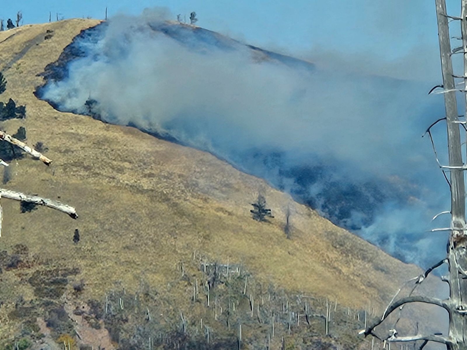
Overview: The Rush Fire is on the Wichita Mountains Wildlife Refuge and lands administered by the Bureau of Indian Affairs and Oklahoma Forestry Services. The Rush Fire is currently 12,488 acres and 48% contained. There are currently 26 engines, 1 Type 1 crew, 2 dozers, 3 helicopters, 3 water tenders and 161 people assigned to the fire.
Operations: Yesterday, a wind advisory had the potential to threaten containment with strong sustained winds and gusts over 50 miles per hour throughout the day. Fortunately, firefighters observed minimal fire activity, dominated by interior pockets of vegetation burning, posing no threat to containment. Along the fire perimeter near Mt. Sheridan Estates and Meers, firefighters moved further interior mopping up with the goal of fully extinguishing hot spots to 100 foot inside the fire edge.
Today, on the northeastern edge of the fire, firefighters continue mop up near Mt. Sheridan Estates and Meers. On the northwestern edge of the fire along Black Bear Springs, a hot shot crew and engines continue to identify and extinguish hot spots and areas of heat. Additional engines have been inserted along the southern perimeter to monitor and patrol north of Hwy 49. The fuels on the fire continue to be extremely dry and grasses have the potential to carry fire quickly in shifting winds conditions. Firefighters will be monitoring weather conditions carefully throughout the day with the chance of rain, but also the potential for strong and shifting winds.
Weather/Fire Behavior: Scattered light showers are possible this morning. Gusts near 35 miles per hour will continue with clouds breaking by early afternoon. Highs will be in the 80s. Rain chances increase by late Wednesday. Light fuels will respond well to precipitation and humidity recovery.
Air Quality: Communities around the Rush Fire will experience Good Air Quality today. Current Smoke Outlook
Evacuations: There are no evacuations in place for the Rush Fire. Residents close to the fire area should stay alert and informed on the current fire situation. Changes to evacuations will be made in consultation between fire managers and the Comanche County Emergency Management. Residents can sign up for the Comanche County Emergency Notifications and Alerts through their website at https://www.comanchecounty.us/emergency-notifications-systems
Closures and Restrictions: Wichita Mountains Wildlife Refuge is currently closed due to smoke impacts from the Rush Fire and to ensure the safety of firefighters and the public. This closure is for all public use areas, including Charon’s Garden Wilderness Area, Dog Run Hollow Trail System, Boulder Cabin and Picnic Areas, Lost Lake, Doris Campground, the Environmental Education Center, the Visitor Center, Holy City, the Parallel Forest, and Mount Scott.
All entrance points to the refuge are closed. There are road closures on Highway 115 at the Cache and Meers Gates, on Highway 49 at the West Gate located Northwest of Charon’s Garden Wilderness Area and at the Medicine Park Refuge entrance. Indiahoma Road is also closed South of Charon’s Garden Wilderness Area. Entering a closed National Wildlife Refuge is a violation of federal law and is cause for fine or arrest.
Comanche County has a countywide burn ban in effect.
A temporary flight restriction is in effect in and around the fire area. The use of personal drones is always prohibited on the Wichita Mountains Wildlife Refuge. If you fly, we cannot fly.
Elk Fire Update 10 30 2024
Related Incident: Elk Fire 2024
Publication Type: News
Elk Fire Update
Wednesday, October 30, 2024 - 9:00 a.m.
Wyoming Interagency Management Type 3 Team
Jon Warder, Incident Commander
Current Situation: Precipitation continues to fall over the fire area this morning, and there are several inches of snow on the ground at higher elevations. Crews are staged at the incident command post this morning until conditions allow them to travel out to their work locations in the fire area. Two graders are standing by to clear the route into Red Grade Road from the west side to allow the Equipment Group personnel access. Due to weather conditions and related hazards yesterday, Suppression repair crews and heavy equipment operators were not sent out to the lines.
The Equipment Group will continue its work to widen defensible space on Red Grade Road. They are using logging equipment to clear trees and create a fuel break to provide fire control options for protecting communities and area watersheds.
The Suppression Repair group will focus on projects at lower elevations in the front range, including fence repair and knocking down berms from dozer line and creating water bars on repaired line, which can reduce erosion impact.
The goal of suppression repair is to return areas disrupted by firefighting suppression tactics to the way they were before the fire.
Weather, Fuels, and Fire Behavior: The storm system will be winding down today, with snow lingering through the morning. High temperatures over the fire area will be in the upper 20’s to lower 30’s, with light winds out of the south and southwest. Tonight will be partly cloudy and very cold, with low temperatures of 8-12 degrees.
Closures and Advisories:
The incident management team is working with the Bighorn National Forest, State Game and Fish, and the Sheridan County Sheriff’s Office to reduce closers on public lands and roads as quickly as possible. Currently, Bighorn National Forest closure Order No. 02-02-06-24-08 remains in effect. The order and map can be viewed here: https://www.fs.usda.gov/alerts/bighorn/alerts-notices.
Elk Fire Statistics: Size: 98,352 acres | Containment: 81% | Total Personnel: 186| Location: West of Sheridan, WY
Reported: September 27, 2024 | Cause: lightning
Comanche County Burn Ban 10 30 2024
Related Incident:
Publication Type: Announcement
The Comanche County Board of County Commissioners pursuant to the authority granted to the Board by
Section 16-26. B of Title 2 of the Oklahoma Statutes, do hereby proclaim that extreme fire danger
exists in Comanche County. This situation (as defined in Section 16-26. B1.a-d, Title 2, 0.5.) has
been verified by a documented concurrence ofthe majority of the County's municipal and rural fire
chiefs, or their designees.
WHEREAS, By virtue of this resolution, it is unlawful for any person to set fire to any forest,
grass, range, crop or other wildlands, or to build a campfire or bonfire, or to burn rubbish or
other material that may cause such a fire. All outdoor burning in progress at the time of the
passage of this resolution not otherwise authorized by law in ordered to be fully extinguished
immediately by the property owner or his/her designate. Controlled/prescribed burns or other
activities stated herein which have occurred prior to the passage of this resolution and are
ongoing at the time of the passage of this resolution shall not be a defense for violation of this
resolution. Fireworks is prohibited. The ignition of fireworks, regarding both private and public
displays, are prohibited for the duration of this burn ban.
WHEREAS, Exception to this fire prohibition and the appropriate precautionary measures to be taken
are as follows:
FOR EQUIPMENT RELATED TO ROAD CONSTRUCTION PROJECTS - Equipment which uses
propane or other controlled-type burners is generally regarded as safe, however it would be prudent
to have a water pumper on standby any time this equipment is used near a grassy right of way.
WELDING/CUTTING TORCH/GRINDING ACTIVITIES - 1. When conducted over a non-combustible surface of at
least 10 feet and when welding blankets or screens are used to cover flammable vegetation; and 2.
Wind speeds must be less than 20 mph; and 3. A fire watch, other than the welder, is posted at the
welding/cutting torch site with pressurized water or fire extinguisher.
CAMPFIRES AND OUTDOOR COOKING - Outdoor campfires or bonfires are prohibited. Charcoal grills, LPG,
and natural gas grills in a grilling receptacle are permitted provided that the activity is
conducted over a non-flammable surface and at least five feet from flammable vegetation.
PRESCRIBED BURNS -Agricultural producers burning cropland, rangeland, forests, or pastures as a
preferred method of managing their property MUST follow Oklahoma Forestry Service
guidelines as outlined in Section 16-26.4, Title 2, O.S.
WHEREAS, Any law enforcement officer of the State of Oklahoma may carry out the enforcement of this
resolution. Any person convicted of violating this resolution shall be guilty of a misdemeanor and shall
be subject to a fine of not more than Fire Hundred Dollars ($500.00}, to imprisonment of not more than
(1) year, or to both such fine and imprisonment.
This resolution shall be effective immediately for a period of fourteen (14) days by the Board of County
Commissioners, with the possibility of extension on a week-to-week basis to be determined at the
Commissioners meeting. If extreme fire danger conditions persist, subsequent resolutions may be
passed. This Burn Ban may be removed at any time by the same method by which it was approved.
This Resolution does NOT apply to Federal Land.
Resolved at a meeting by the Board of Comanche County Commissioners at 2:00 pm on October 29,
2024.
Comanche County
FIRE SUMMARY OCTOBER 28 2024 10 28 2024
Related Incident:
Publication Type: News
The Central Idaho Dispatch Zone is at HIGH Fire Danger
There has been one (1) new fire reported on the Salmon-Challis National Forest since the last update on Monday, October 21, 2024. To date, there have been 67 wildfires reported on the Salmon-Challis National Forest. 59 of the fires have been declared out.
Ellis (October 22): is approximately 10 miles north of Challis on the Challis-Yankee Fork Ranger District. The fire 0.10 acre fire burning in grass, spruce, and fir is out.
Nugget (September 13): is located approximately 40 miles west of Salmon on the North Fork Ranger District in the Frank Church River of No Return Wilderness. The 1,001 acre fire is burning in fir. The fire can be found on InciWeb at https://inciweb.wildfire.gov/incident-information/idscf-nugget-fire.
Garden (September 8): is located approximately two (2) miles southwest of the confluence of Panther Creek and the Main Salmon River on the North Fork Ranger District in the Frank Church River of No Return Wilderness. The fire is 100% complete and is no longer being updated daily. Currently, the fires is being managed by a Complex Incident Management Team.
Vanity (September 3): is located approximately 42 miles west of Challis on the Middle Fork Ranger District. The approximately 600 acre fire is burning in subalpine fir is out.
Red Rock (September 2): is located approximately two (2) miles east of Yellowjacket Guard Station on the Salmon-Cobalt Ranger District. A Complex Incident Management Team is managing the fire, and information is being reported separately. The fire can be found on InciWeb at https://inciweb.wildfire.gov/incident-information/idscf-red-rock-fire.
Reynolds (August 22): is located approximately 21 miles northwest of Indianola on the Idaho/Montana border. Fire is estimated to be approximately 2,671 acres burning in spruce and fir. The Bitterroot National Forest is lead on this fire.
Birch (August 17): is located on the west side of the Middle Fork of the Salmon River on Norton Ridge on the Middle Fork Ranger District in the Frank Church River of No Return Wilderness. The 23,043 acre fire is burning in subalpine fir. The fire can be found on InciWeb at https://inciweb.wildfire.gov/incident-information/idscf-birch-fire.
Greyhound (August 11): is located approximately 46 miles northwest of Challis on the Middle Fork Ranger District. The 97 acre fire is burning in subalpine fir and lodgepole pine is out.
Wapiti (July 24): started on the Boise National Forest, burned onto the Sawtooth National, and around August 24th burned onto the Salmon-Challis National Forest. Information can be found on InciWeb at https://inciweb.wildfire.gov/incident-information/idbof-wapiti-fire.
Thunder (July 24): The lightning fire located approximately 12 miles southwest of Salmon. The 2,474 acre fire burning in timber, sagebrush, and grass is out.
Weather: Seasonably cool and unsettled weather will return for much of this upcoming week as a series of Pacific systems work through the northern Rockies. One system today into Tuesday and another Thursday through Saturday will support isolated to scattered rain and snow showers with high temperatures each day this week in the 30s/40s.
The forest is asking visitors to be aware of the HIGH fire danger for the Salmon-Challis National Forest. Ensure your campfire is dead out. If it is too hot to touch, it is too hot to leave! One Less Spark Means One Less Wildfire. Since June 1, Forest employees have found and extinguished at least 17 abandoned campfires.
Nationally, there are 11 uncontained large fires being managed under a full suppression strategy and 2 large fires managed under a strategy other than full suppression.
Visit our website at: www.fs.usda.gov/scnf/, ‘Like Us’ on Facebook @salmonchallisnf, and ‘Follow Us’ on X @salmonchallisnf.
Smoke Outlook Rush Fire 10 30 2024
Related Incident:
Publication Type: News
Smoke Outlook for Rush Fire for October 30-31, 2024
FIRE
The Rush Fire fire is currently estimated at 12488 acres and is 48% contained. Fire activity for the Rush Fire fire is expected to remain low.
SMOKE
South winds again today 17-23 mph with possible gusts around 38 mph expected in the forecast area. Light periods of smoke will be visible in the interior pockets and north/west corner where fire activity continues. Light showers overnight in the forecast area. Counties directly north of the fire will see periods of light smoke throughout the day. Overall GOOD air quality throughout the forecast area today.
HEALTH STATEMENT
Smoke can be harmful to your health. Check with your doctor if there are any health concerns and monitor your local air quality conditions using the Fire and Smoke Map.
Blue Front Evening Update 10 29 2024
Related Incident: Blue Front Fire
Publication Type: News
Blue Front Fire Evening Update, October 29, 2024
Start Date / Time: October 28, 2024
Cause: Unknown
Size: 270 acres
Location: 4 miles west of Alto, located in the Blue 2 wildfire footprint in the White Mountain Wilderness.
Resources: Smokey Bear Hotshot Module and Sacramento Hotshot Module, Engine 612 (Type 6), Engine 311 (Type 3), Type 1 helicopter, incoming Type 3 crews and resources
Types of vegetation in the area (aka fuels): Grass, shrubs, dead/down fuels
Containment: 0% Strategy: Full Suppression Road Closures: None Smoke: Light
Update: High wind speeds and gusts, along with warmer temperatures resulted in fire spread through grass and dead/down fuels throughout the wildfire footprint. Aviation assets were grounded due to high winds. Crews worked on the ground to establish containment lines.
Resources will remain on-scene through the night, with some stationed along the South Fork Trail to ensure fire remains on the north side of the mountain face.
Resources for a Type 3 organization are currently arriving on the Lincoln to support response efforts. Crews will continue to arrive this week. Air support will also be utilized as often as weather permits.
Weather: Today, unseasonably warm temperatures and high wind speeds will be a factor in fire growth. No precipitation is expected.
Evacuations: None at this time. Homes in the Bonito Lake area are in a ‘ready’ status from the Lincoln County Emergency Management. ‘Ready’ status means that residents should be prepared to evacuate. Please pay close attention to emergency announcements. You can sign up for emergency text notifications from Lincoln County at https://www.onsolve.com/landing/sign-up-for-codered-emergency-alerts/.
More Information:
Facebook: www.facebook.com/LincolnNationalForest NM Fire Info: www.NMFireInfo.com
.jpg?VersionId=ObVLDF0Oaxr0hY3YSNIuMtnPY41XaBj0)
Blue Front Fire Afternoon Update 10 29 2024
Related Incident: Blue Front Fire
Publication Type: News
Start Date / Time: October 28, 2024
Cause: Unknown
Size: 270 acres
Location: 4 miles west of Alto, located in the Blue 2 wildfire footprint in the White Mountain Wilderness.
Resources: Smokey Bear Hotshot Module and Sacramento Hotshot Module, Engine 612 (Type 6), Engine 311 (Type 3), Type 1 helicopter
Types of vegetation in the area (aka fuels): Grass, shrubs, dead/down fuels
Containment: 0% Strategy: Full Suppression Road Closures: None Smoke: Light
Update: The Blue Front Fire was detected on the Smokey Bear Ranger District of the Lincoln National Forest on October 28, 2024. The wildfire is located within the White Mountain Wilderness Area, in the footprint of the 2024 Blue 2 Fire.
Smokey Bear Hotshots, along with local firefighting agencies, responded on-scene yesterday, with resources remaining overnight. Today, crews remain on scene, and helicopter is utilizing bucket drops when possible, however, windy conditions are affecting flight capabilities.
Sustained winds of 25 mph, and gusts of up to 50 mph are expected to continue throughout the day. On the upper west shoulder of the fire, containment lines are holding, and on the east side of the fire, there is a higher concentration of smoke.
Because of the warm weather and high winds, fire activity and growth is expected today, however, no values or resources are threatened at this time.
Weather: Today, unseasonably warm temperatures and high wind speeds will be a factor in fire growth. No precipitation is expected.
Evacuations: None at this time. Homes in the Bonito Lake area are in a ‘ready’ status from the Lincoln County Emergency Management. ‘Ready’ status means that residents should be prepared to evacuate. Please pay close attention to emergency announcements. You can sign up for emergency text notifications from Lincoln County at https://www.onsolve.com/landing/sign-up-for-codered-emergency-alerts/.
More Information:
Facebook: www.facebook.com/LincolnNationalForest NM Fire Info: www.NMFireInfo.com
October 30 2024 Pile Burn Update 10 29 2024
Related Incident:
Publication Type: News
Yesterday was a successful day of prescribed fire operations across many of our districts, work will continue today and throughout the rest of this week, pending conditions.
Plains/Thompson Falls Ranger District: Prescribed fire operations will continue on the River Road East Fire piles located near Pats Knob west of Paradise. Smoke may be visible from Paradise, Knowles, Quinns, Highway 200 and Highway 135.
Seeley Lake Ranger District: Firefighters will conduct up to 10 acres of pile burning on the Westside Bypass Project area is located 4 miles northwest of Seeley Lake. Smoke may be visible from Seeley Lake and Highway 83.
Superior Ranger District: Pile burning operations will continue today on the Superior Ranger District 7 miles southeast of Superior in the Pierson Creek drainage. Fire managers will burn up to 60 acres of landing piles. The piles are a result from previous management operations on the Lost Creek Timber Sale. Smoke may be visible from Superior.
More information on prescribed fire: https://www.fs.usda.gov/main/lolo/fire.
Settings - change map background and toggle additional layers
Filter - control incident types displayed on map.
Zoom to your location
Reset map zoom and position
Could not determine your location.
Show Legend
 Wildfire
 Prescribed Fire
 Burned Area
Response
Burned Area
Response Other
Other
Front Country Prescribed Fire
Unit Information
Incident Contacts
Smoke Outlook Rush Fire 10 29 2024
Related Incident:
Publication Type: News
Rush Fire Smoke Outlook for Oct 29-30, 2024
FIRE
The Rush Fire fire is currently estimated at 12497 acres and is 48% contained. Fire activity for the Rush Fire is expected to decrease.
SMOKE
South winds again today 23-29 mph with possible gusts around 48 mph expected in the forecast area. Light periods of smoke will be visible in the interior pockets and north/west corner where fire activity continues. Counties directly north of the fire will see periods of smoke throughout the day. Overall GOOD air quality throughout theforecast area today.
HEALTH STATEMENT
Smoke can be harmful to your health.Check with your doctor if there are anyhealth concerns and monitor your local air quality conditions using the Fire and Smoke Map.