
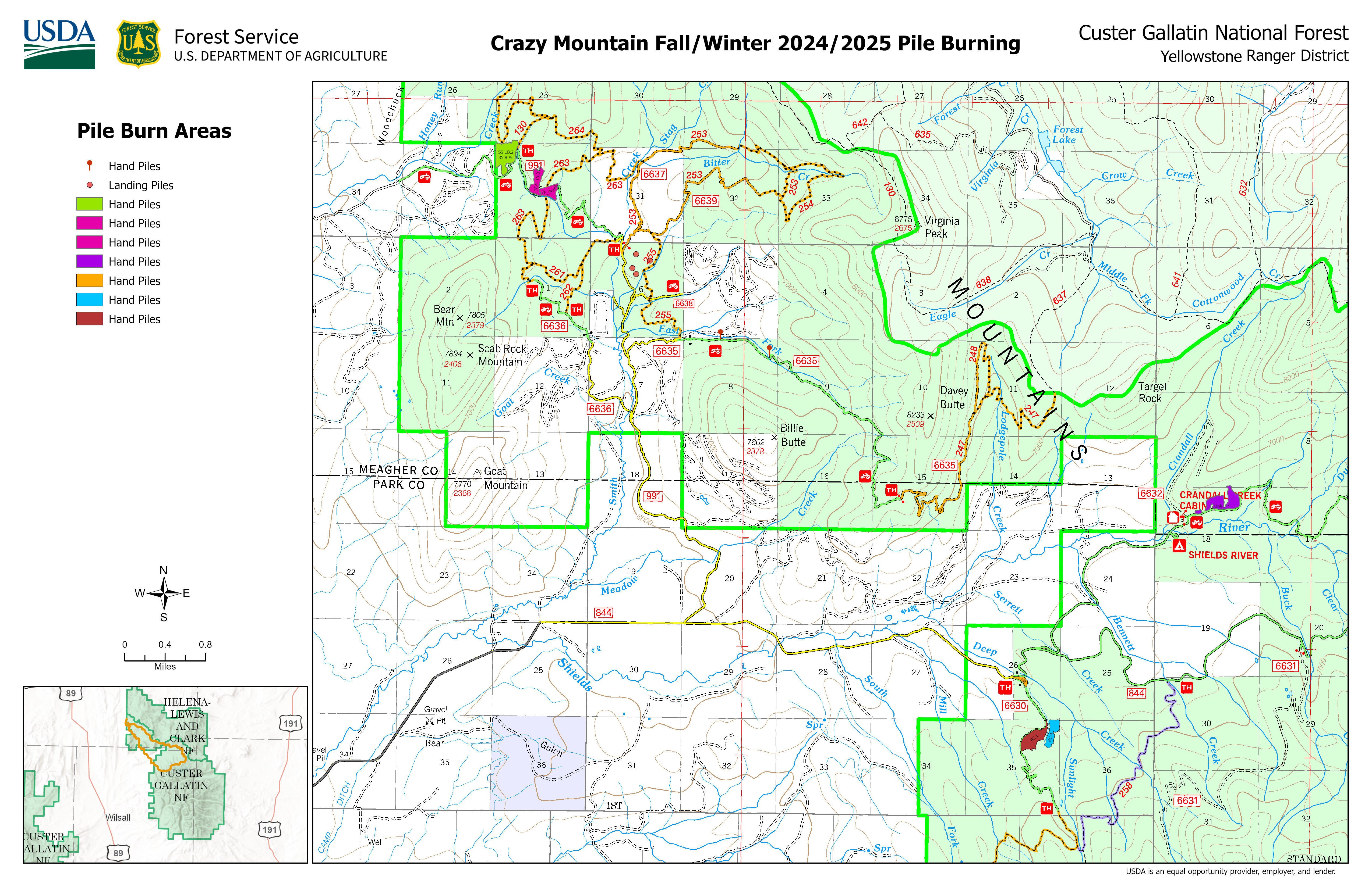
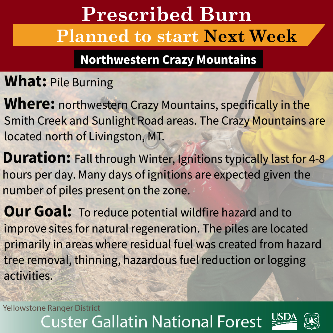
Pile Burning in Northwest Crazy Mountains to begin as soon as Monday Oct 28 2024 and continue through fallwinter 10 24 2024
Related Incident: 2024 Custer Gallatin National Forest Prescribed Fire Program
Publication Type: Announcement
Depending on weather conditions, pile burning activities will likely begin next week, as soon as Monday, October 28, 2024 and will continue as conditions allow this fall through the winter in the northwestern Crazy Mountains, specifically in the Smith Creek and Sunlight Road areas. The Crazy Mountains are located north of Livingston, MT.
The piles to be burned are part of the Smith Shields Forest Health project and are a result of thinning to improve forest health and reduce fuels to moderate fire intensity along key corridors. The piles are located primarily in areas where residual fuel was created from hazard tree removal, thinning, hazardous fuel reduction or logging activities. Adjacent fuels are not expected to be receptive to fire during pile burning due to consistent snowpack or high moisture content.
Pile burning activities in the Crazy Mountains will only be ignited when conditions are met including high fuel moisture or snow.
Fall and winter provides ideal conditions for pile burning, with higher fuel moistures and cooler temperatures. Conducting burns in this season helps prevent out-of-control wildfires during the hotter months.
Pile burning activities in the Crazy Mountains were previously postponed due to drier than expected conditions and high winds.
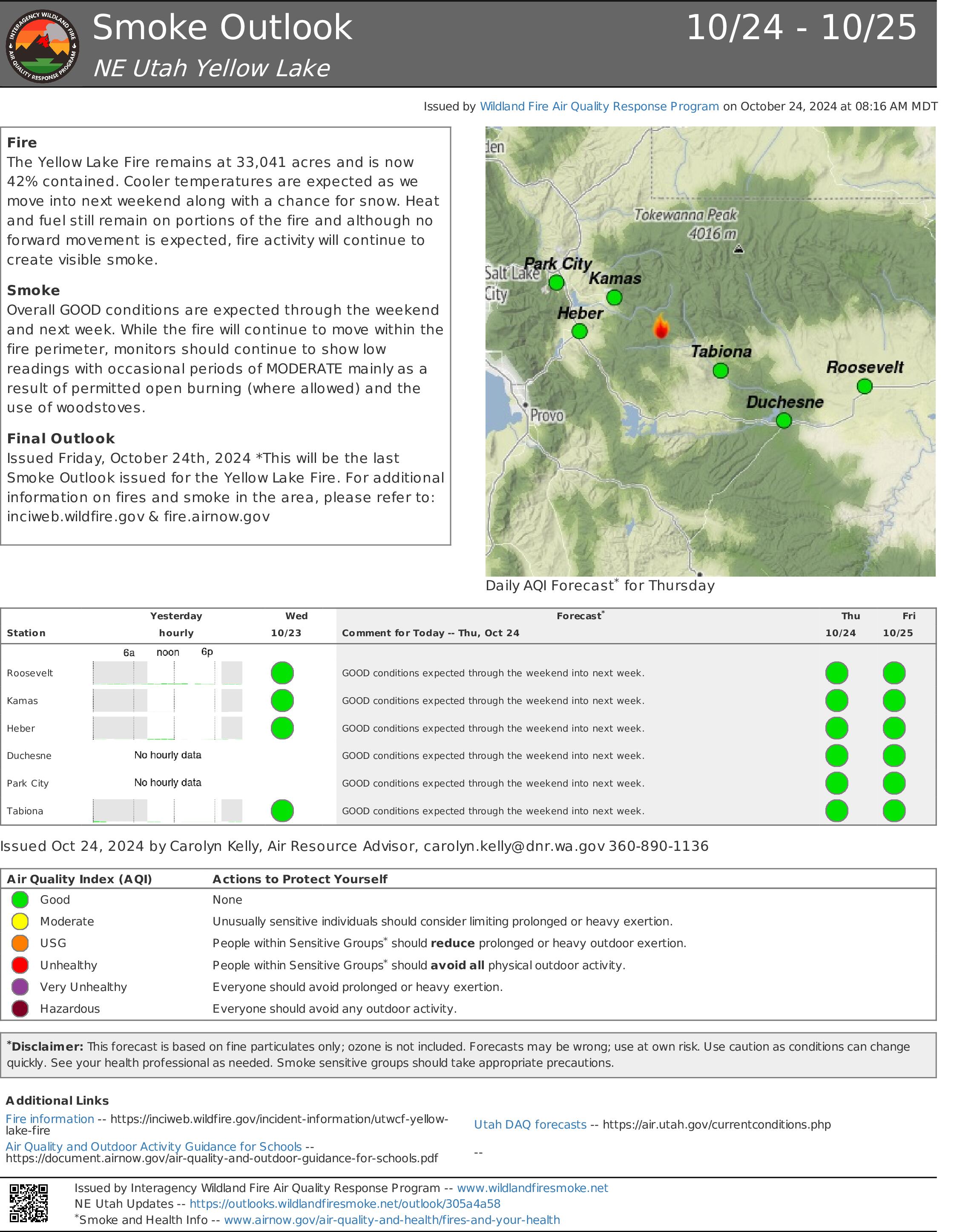
Yellow Lake Fire Update 10 24 2024
Related Incident: Yellow Lake Fire
Publication Type: News
Size at time of update: 33,041 Acres
Containment: 42%
Personnel: 223
There will be a virtual public meeting tonight at 6 p.m. The event will be livestreamed on the Ashley National Forest and Uinta-Wasatch-Cache National Forest Facebook pages.
Resources continued to work sections of the Yellow Lake Fire’s perimeter increasing containment to 42% Wednesday. The fire has not grown in several days.
Crews continue to remove hazard trees, find and extinguish hot spots, and repair handline, dozer line, and other impacts caused while fighting the fire. Along the north half of the fire around Lambert Hollow, firefighters increased containment and remove hazard trees weakened by fire. On the south side of the fire around Tim’s Hole, firefighters worked on extinguishing hot spots still remaining despite the cooler temperatures. Containment will increase once heat is extinguished far enough inside the fire’s perimeter. Resources also helped heavy equipment regrade Soapstone Road, improving the road after increased traffic during suppression efforts. The bulldozer line along West Fork of the Duchesne River was also repaired.
Relative humidity remains low for the time of year, but humidity overnight has been favorable to firefighters extinguishing hot spots along the uncontained fire edge. After days of warmer weather, a cold front moves in today accompanied by stronger winds that will subside this afternoon. Temperatures will then remain cooler for the next few days with snow and rain forecasted next week.
To request a permit to access property within the forest closures to retrieve important items, livestock, or winterize buildings, please contact the liaison officer at 2024.yellowlake.liaison@firenet.gov.
Forest Closures:
- Updated October 18, 2024, the Yellow Lake Fire closure area has been reduced on the Uinta-Wasatch-Cache National Forest. This Order shall remain in effect until November 25, 2024, unless rescinded.
https://www.fs.usda.gov/alerts/uwcnf/alerts-notices
- Updated October 19, 2024, the Yellow Lake Fire closure area has been reduced on the Ashley National Forest. This closure will remain in place through December 31, 2024, or until rescinded. https://www.fs.usda.gov/alerts/ashley/alerts-notices
For Evacuation Information:
https://emergency-management-operations-wasatch.hub.arcgis.com/
Shoe Fire Daily Update for 10 24 2024
Related Incident: Shoe Fire
Publication Type: News
Email: 2024.shoe@firenet.gov
Incident Website: https://inciweb.wildfire.gov/incident-information/cashf-shoe-fire
Forest Website: https://www.fs.usda.gov/stnf
Fire Weather Forecast: https://www.weather.gov/wrh/CAFW?area=ECC005
Fire Information: 530-338-0317
Hours: 08:00am to 8:00pm
Location: Shasta County, CA Start Date: Wednesday, October 9, 2024, at 6:57 p.m.
Cause: Human caused Size: 5,127
Percent Contained: 45% Vegetation: Timber, Chapparal
Number of Personnel Assigned: 856
California Team 13 will transfer command to the Pacific Northwest Team 12 on October 25th. Firefighters have commenced the withdraw of up to five miles of hose lays and heavy equipment from divisions that have been contained and mopped up. Hot, dry and windy conditions persist today across the fire today. Fire crews continue to mop up and secure areas of concern around the clock to ensure the fire stays within the current containment lines. Aircraft will remain on standby to provide suppression support. Incident personnel are actively collaborating with resource advisors to repair and safeguard areas affected by fire damage. Resource advisors work in conjunction with operations to protect cultural, natural, and other forest resources.
WEATHER:
Today winds from the north to northwest are anticipated, with the potential for locally strong gusts, particularly along ridges and in areas characterized by channeled terrain. Relative humidity, which remained low last night is expected to decrease further today with minimum relative humidity levels projected to be in the mid to upper teens for both today and Friday. Additionally, poor overnight recovery of humidity is expected along slopes and ridges tonight.
EVACUATIONS: Due to improving conditions on the Shoe Fire burning north of Lake Shasta, in cooperation with fire officials, the Shasta County Sheriff’s Office is reducing the Evacuation order for zone LKH-1448-B to an Evacuation WARNING.
Information staff for the Shoe Fire are working diligently to provide timely and accurate information to the public. Fire updates can be found on the Shoe Fire 2024 Facebook page: www.facebook.com/2024ShoeFire/
FIRE AND SMOKE MAP:
Updates on smoke conditions can be found under the following link
https://outlooks.wildlandfiresmoke.net/outlook/59ecb6c0?
ROAD CLOSURES:
- Fenders Ferry Road at Pit River 7 Bridge: West-Bound Fenders Ferry Road (Also known as 34N17 - Forest Service Road 27) at the Pit River Bridge/Pit 7
- Ferry Road is closed at McCloud Bridge: East-Bound Fenders Ferry Road at the McCloud River Bridge
FOREST CLOSURES:
https://www.fs.usda.gov/detailfull/stnf/alerts-notices/?cid=stelprdb5392380
Settings - change map background and toggle additional layers
Filter - control incident types displayed on map.
Zoom to your location
Reset map zoom and position
Could not determine your location.
Show Legend
 Wildfire
 Prescribed Fire
 Burned Area
Response
Burned Area
Response Other
Other
Bridge Fire, 10/23/24 Update
Unit Information
Incident Contacts
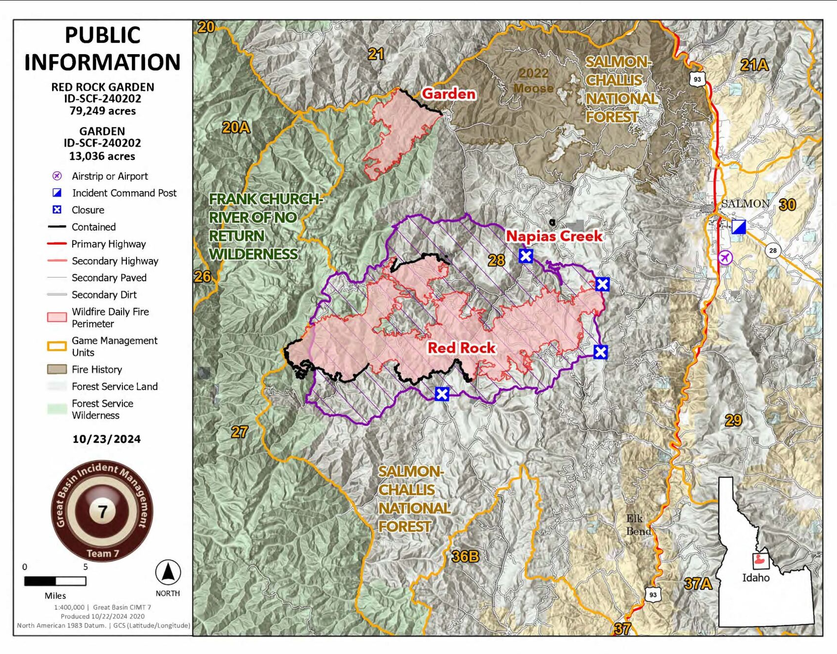
All Red Rock Fire Evacuation Zones Rescinded 10 24 2024
Related Incident:
Publication Type: Announcement
RED ROCK FIRE EVACUATION UPDATE
10/24/2024
9:00 HOURS
Fire Size: 79,249 Acres
Completion: 62%
Total Personnel: 394
THERE HAVE BEEN CHANGES TO THE EVACUATION ZONES, THEY ARE AS FOLLOWS:
ZONE 1 – HAS BEEN RESCINDED
ZONE 2 – HAS BEEN RESCINDED
ZONE 3 – HAS BEEN RESCINDED
ZONE 4 – RESCINDED
ZONE 5 – HAS BEEN RESCINDED
ZONE 6A – RESCINDED
ZONE 6B – RESCINDED
Zone 1: Yellowjacket drainage
Zone 2: Cobalt to Forney
Zone 3: Forney to road #252 to road #103 and back to Moyer
Zone 4: Silver Creek, Rams Creek, and Camas Creek from Hammer
Creek to White Goat Creek
Zone 5: Cobalt to Blackbird and Leesburg
Zone 6A: Perreau Creek to Rattlesnake Drainage
Zone 6B: Rattlesnake Drainage to include all of Elk Bend and the 93 S Corridor
Pack Trail Daily Update October 24 2024 10 24 2024
Related Incident:
Publication Type: News
Total Acres: 89,645
Confined: 66%
Total Personnel: 565
Operations – On the north side of the Pack Trail Fire, crews continue to complete fire suppression repair where there is little
fire activity. On the east flank, crews will begin to break down structure protection equipment along Highway 26. Firefighters will assess and improve confinement lines along the 540 Road and the Lava Burn Scar connecting to natural features on Lava Mountain. Cold trailing continues along the fire edge as safety hazards allow. On the southwestern flank, crews are securing the edge of the fire, extinguishing hot spots and cold trailing from Park Creek to the West into Bacon Creek and Bang Creek.
Firing operations may take place where conditions and crew capabilities allow. The precipitation received overnight is
anticipated to help fire crews secure the fire edge even further. To aid in their mission to seek out and eliminate sources of heat on the fire line, they will be using a fixed-wing Unmanned Aircraft system (UAS). This technology is an effective application for use in steep, rugged terrain to be as efficient as possible while covering large tracks of land in little time.
Safety – Despite the recent precipitation, Teton Interagency Fire Managers are maintaining the Very High Fire Danger Rating for Grand Teton National Park, the Bridger-Teton National Forest, the Shoshone National Forest, and the National Elk Refuge. This precipitation was not a fire season-ending event. Due to wind, fuels will begin to rapidly dry out when the snow melts.
Residents and visitors are reminded to exercise extreme caution when dealing with fires or other possible ignition sources.
Please use caution while driving in these areas, especially on narrow secondary roads. Always expect to encounter fire vehicles and heavy equipment in and around the fire area. Check with WY-DOT for possible closures due to fire activity, especially if you are planning to travel on US-26 across the Continental Divide. Closures are not expected, but with active fire in the area checking status before travel is recommended.
“If you fly, we can’t.” Remember that flying a personal drone over a fire area during a temporary flight restriction is illegal and can be an extremely dangerous threat to both our aviators and firefighters on the ground.
Weather – Today will be mostly cloudy with temperatures of 39-44 degrees with minimum relative humidities from 39% - 44%. Winds from the west to northwest will be 6-11 MPH with gusts up to 23. A cold front will bring increased cloud cover and a chance for precipitation today before high-pressure returns for the weekend. Snow and rain showers diminish this morning, giving way to colder temperatures and higher humidities compared to the last two days. To learn more about air quality, visit Fire.AirNow.Gov.
Evacuations – Lava Mountain Lodge, Roaring River Subdivision, Buckboard Subdivision, Double Bar J Ranch, Lava Creek Ranch, Triangle C Ranch, Pelham Lake, Sheridan Creek Camp Areas, Old Mackenzie Ranch, Upper Gros Ventre, Darwin Ranch have been reduced to Level 2 “Set” status. Brooks Lake Lodge, Pinnacle, Breccia, and Long Creek, and Dunior areas have been reduced to a Level 1 “Ready” status. Union Pass subdivision remains in a Level 2 “Set” status. See the Fremont County Emergency Management Facebook Page for alerts and updates. See the Teton County Emergency Management website updates and to sign up for emergency alerts through Everbridge.
Road Closures – The Union Pass Road is closed on the Pinedale Ranger District (BTNF) from Mosquito Lake to the Moon Lake Road on the Wind River District (SHO). Moon Lake Road is also closed.
Forest Closures - Closure Order #04-03-24-317 is in effect from October 14, 2024, at 12:00 p.m. through November 15, 2024 at 12:00 a.m. unless rescinded. This order supersedes previous orders, including #04-03-24-316, prohibiting the same or similar acts in the same described area.
For more information, visit: Facebook: USDA Forest Service - Bridger-Teton National Forest, USDA Forest Service - Shoshone National Forest Pack Trail Inciweb: https://inciweb.wildfire.gov/incident-information/wybtf-pack-trail-fire
Garden and Red Rock Fires Update 10 24 2024
Related Incident:
Publication Type: News
Highlights:
Weather changes have significantly reduced fire activity, prompting a shift in suppression strategy for the Red Rock and Garden Fires to a mix of containment and confinement tactics. This approach involves actions both directly adjacent to the fire perimeter and further away, including full suppression, confinement to predetermined natural barriers, and the protection of values such as private property and infrastructure. This combination of tactics enables fire managers to effectively address the 321 miles of fire perimeter for the Red Rock and Garden Fires.
Containment means that control lines have been constructed around the fire, and once completed, they are expected to effectively stop its spread. Confinement utilizes natural geographic features—such as rock bands, ridges, burn scars, or changes in fuel types—that are anticipated to contain any fire growth. Both strategies are represented as percentages, which, when combined, will indicate overall “completion.” Moving forward, the Red Rock and Garden Fires will be reported as a percentage of completion. The priority remains on protecting values and ensuring the safety of both firefighters and the public.
Red Rock Fire
Operations:
Containment tactics have secured the fire's edge near the Blackbird Mine, 4th of July Creek/Forney and the Yellowjacket area. Throughout the fire, crews are working to remove and backhaul pumps and hose lays that were used to suppress, mop up, and provide point protection to values at risk. Excavators have completed repairing dozer line near the Blackbird Mine and are moving to join other equipment making repairs in the vicinity of the Ridge Road. In the Yellowjacket area more dozer line is being repaired. Additionally, road graders are working to repair the impacts of increased travel and heavy equipment along the Morgan/Panther Creek road through the middle of the fire.
Garden Fire
Operations:
Resources are actively patrolling the north and northeast sides of the fire, particularly along Panther Creek/Morgan Creek Road, looking for any remaining heat.
Additional Information
Weather: Morning clouds are anticipated to clear, leading to a sunny afternoon with cooler temperatures. Winds are expected to calm, and high humidity will help maintain minimal fire activity.
Closures: The Red Rock Closure Order, Number: 04-13-24-027 remains in effect. For more info: https://www.fs.usda.gov/alerts/scnf/alerts-notices. Please adhere to closure orders, this remains an active fire area. It is important for both the safety of the public and the firefighters working in the area. Barricade closures will be posted at road intersections and forest boundaries. In coordination with the Lemhi County Sheriff's Office and the Salmon-Challis National Forest, residents of Yellowjacket and Panther Creek can use the road to access their property, checking in with the road guard.
Evacuations: All evacuation zones for the Garden Fire have been lifted. For evacuation information on the Red Rock Fire please go to: https://www.lemhicountyidaho.org/.

Elk Fire Update 10 24 2024
Related Incident: Elk Fire 2024
Publication Type: News
Elk Fire Update
Wednesday, October 24, 2024 - 9:00 a.m.
Rocky Mountain Complex Incident Management Team 1
Dan Dallas, Incident Commander
Special Notes: Agency Administrators in coordination with CIMT have developed a process to allow owners of recreational equipment such as campers to retrieve their personal property. To gain access to the closure area for this purpose, the following form must be filled out: https://forms.office.com/g/P7vrvgQW5d. The form will close at 9 am on Friday, October 25. Additional details regarding entry into the area, including timing of entry and process, will be emailed to those who will be allowed into the closure area.
The Elk Fire Incident Command Post move to the Sheridan County Fairgrounds will be completed today allowing for a centralized location in closer proximity to ongoing work. Motorists are reminded to drive with caution, follow posted speed limits, and be alert for firefighters traveling and working along roads. This includes U.S. Highway 14 where motorists should also expect travel delays as repair work is ongoing.
Current Situation: As expected, fire activity remained consistent with the past few days with no perimeter growth due to elevated humidity and recent precipitation. Firefighters took advantage of these conditions by continuing indirect fireline construction, extinguishing areas of heat on fire edges, and conducting suppression repair operations.
Today, fire behavior will once again be sluggish due to high humidity, cloud cover, foggy conditions, and precipitation. Due to wet slick road conditions, firefighters will use extra caution as they continue work of the last several days. This will include building toward further extension and strengthening of uncontained firelines while also focusing on suppression repair. The bulk of heavy equipment resources will be working to establish fireline along the southwestern edge by creating defensible space on the Red Grade Road and Forest Road 26.
Division A: This remote division is being observed with aircraft and remains unstaffed due to firefighter safety concerns associated with steep rugged terrain, heavy dead and down fuel loads, and slick road conditions.
Divisions Z, P, M, K, I: The fire is out in most of these divisions due to the grassy fuels, recent moisture, and elevated humidities. In the northwest corner, dozer line was constructed to connect contained and uncontained fireline. Firefighters worked to prevent additional fire spread to the north and further secure structures in the Red Canyon area. On the eastern side, suppression repair operations are nearly complete and have consisted of rehabilitating dozer lines by pulling topsoil and vegetation debris across them and placing earthen water control features on slopes. These efforts minimize soil erosion and promote vegetation growth in the future. Within these divisions, there were two primary areas of concern where excessive heat was located in close proximity to fireline, Tongue Canyon Road and Rapid Creek Road. Firefighters were successful in mopping up these heat sources. Today, firefighters will assess yesterday’s efforts and strive to complete remaining tasks. Excess resources will be reprioritized to other parts of the fire, released to other incidents, or receive days off.
Division H: Additional heavy equipment arrived yesterday to support expansion of defensible space along the Red Grade Road and Forest Road 26. These efforts will create a wide fireline while maintaining vegetative tree cover known as a “shaded fuel break.” This work will continue north over the next several days and is planned to connect with Highway 14.
Divisions D, F: Indirect fireline construction was completed along Forest Road 15. In other parts of these divisions, firefighters worked to improve firelines and remove vegetation debris aided by a chipper. Suppression repair occurred on dozer lines around Burgess Work Center and Hate Creek. These operations will continue today.
Weather, Fuels, and Fire Behavior: Overnight, humidity was approximately 100% as much of the fire received some rain or snow. These conditions will persist through this morning with afternoon temperatures warming above 50 degrees, humidity remaining high and light winds with gusts about 20 mph. Today, fire activity will remain minimal throughout the day due to the increased moisture levels. On Friday and over the weekend, weather will warm and dry promoting burning with some visible smoke. Another front will move through early next week.
Evacuation Notices: A Ready Evacuation status exists for several areas in proximity to the Elk Fire. For additional information about evacuation status, go to Johnson County and Sheridan County respective websites: Johnson County Emergency Management’s Facebook page https://www.facebook.com/JohnsonCoWYEMC and Sheridan County Emergency Management website www.tinyurl.com/2s38bcc5. You may also contact Sheridan County Sheriff’s Office (307-672-3455) or Sheridan County Emergency Management (307-752-2174).
Closures and Advisories: A Temporary Flight Restriction is in place over the Elk Fire. Wildfires are a no-fly zone for unauthorized aircraft, including drones. If you fly, we can’t. For more information, visit http://knowbeforeyoufly.org.
US Highway 14 between Burgess Junction and Dayton is open, restrictions are in place for some commercial vehicles based on weight and size. Red Grade Road and County Road 89 from Dayton to Beckton Junction are closed. County Road 335 is closed from the intersection of County Road 335 and Brinton Road to the west. Additional information may be obtained at https://www.wyoroad.info/.
Bighorn National Forest closure Order No. 02-02-06-24-08 remains in effect. The order and map can be viewed here: https://www.fs.usda.gov/alerts/bighorn/alerts-notices .
Elk Fire Statistics:
Size: 96,370 acres | Containment: 52% | Total Personnel: 537 | Location: West of Sheridan, WY
Reported: September 27, 2024 | Cause: lightning
###
October 24 2024 Prescribed Fire Pile Burning Update 10 24 2024
Related Incident:
Publication Type: News
Pile burning operations will begin today and will continue as conditions allow through the fall across the Lolo National Forest.
The Superior Ranger District plans to burn up to 25 acres of landing piles today, located 5 miles northeast of Superior in the Flat Creek and Idaho Gulch drainages. The landing piles are a result of the Hall Wood Timber Sale created from previous logging activities. Piles are typically burned in fall, winter, or early spring after the piles have dried out and conditions allow, reducing the damage to the remaining trees and confining the majority of fire to the footprint of the pile. Smoke may be visible from Superior and I-90.
All prescribed fires are implemented in compliance with Montana air quality standards and coordinated with the Montana Department of Environmental Quality and the appropriate county health departments to reduce the impacts of smoke to neighbors, cooperators, and surrounding communities. For additional information on air quality, smoke management, and forecasts, see https://mi.airshedgroup.org/.
Virtual Community Meeting 6 pm October 24 2024 for Yellow Lake Fire 10 23 2024
Related Incident: Yellow Lake Fire
Publication Type: Announcement
The Northern Utah Type 3 IMT will host a Virtual Community Meeting for Yellow Lake Fire on Thursday, October 24, 2024 at 6pm. This virtual meeting will not include a physical meeting location, but will be livestreamed via both the Ashley National Forest and Uinta-Wasatch-Cache National Forest Facebook pages to ensure all interested audiences may attend or watch later.