
Settings - change map background and toggle additional layers
Filter - control incident types displayed on map.
Zoom to your location
Reset map zoom and position
Could not determine your location.
Show Legend
 Wildfire
 Prescribed Fire
 Burned Area
Response
Burned Area
Response Other
Other
Bridge Fire, 10/20/24
Unit Information
Incident Contacts
Update No changes to evacuation statusroad closures 10 23 2024
Related Incident: Elk Fire 2024
Publication Type: News
No Changes to Evacuation Status or Road Closures as Fire Suppression and Restoration Work Continue
Sheridan County, 10/23/2024 2:30 p.m. – In response to ongoing fire suppression and restoration efforts, officials have announced that no changes will be made today to the current evacuation statuses or road closures.
Road Closures
- Red Grade Road remains under a hard closure, with access restricted to fire personnel only.
- Closed roadways are being used for restoration work and heavy machinery, making public access unsafe at this time.
Officials will continue to evaluate the needs of the Elk Fire Incident Management Team and make adjustments to public access when it is safe to do so. We appreciate the public’s understanding and cooperation as fire crews work to control the fire and restore the affected areas.
Sheridan County Emergency ManagementPhone: 307-752-2174
The Elk Fire information hotline: 307-303-7642
Sheridan County Web Site: www.sheridancountywy.gov
Follow us on Facebook at https://www.facebook.com/SheridanCountyGovernment for live updates.
###
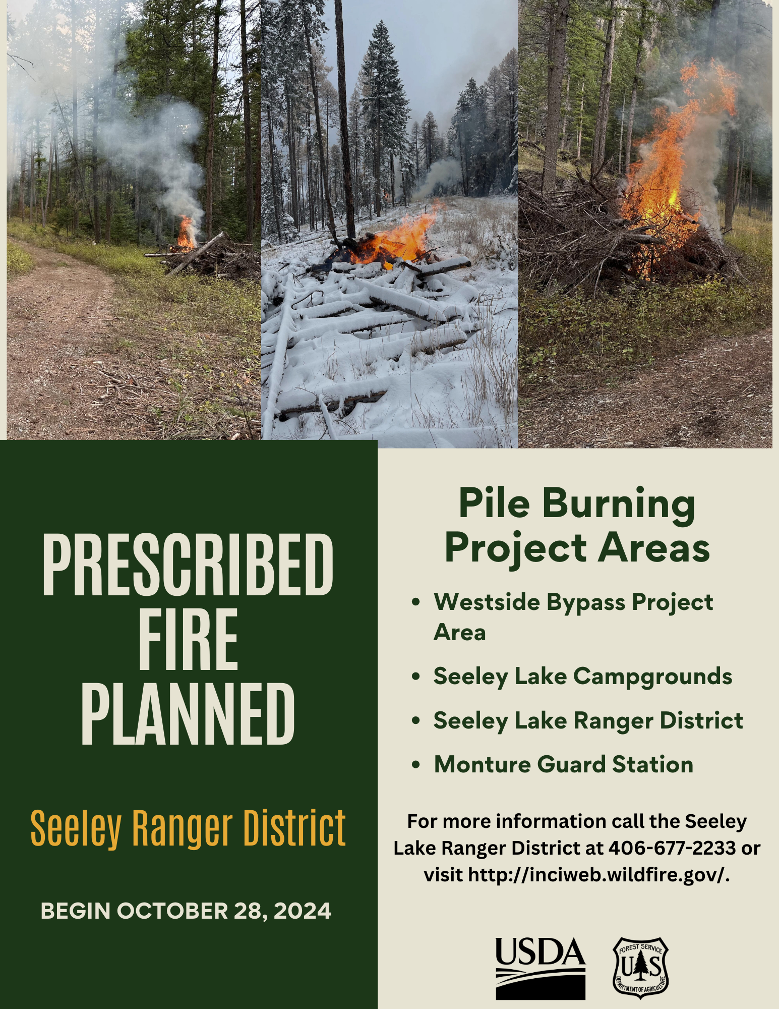
Seeley Lake Ranger District Pile Burning Planned Oct 28 10 23 2024
Related Incident:
Publication Type: News
Pending favorable conditions, the Seeley Lake Ranger District plans to conduct prescribed pile burning to reduce hazardous fuels and restore healthy forest conditions and wildlife habitat. Pile burn operations will take place in the Westside Bypass project area, Seeley Campgrounds, Seeley Lake Ranger District Office, Monture and Guard Station. Operations could begin as soon as October 28th, 2024.

Shoe Fire Daily Update for 10 23 2024
Related Incident: Shoe Fire
Publication Type: News
Incident Website: https://inciweb.wildfire.gov/incident-information/cashf-shoe-fire
Forest Website: https://www.fs.usda.gov/stnf
Fire Weather Forecast: https://www.weather.gov/wrh/CAFW?area=ECC005
Fire Information: 530-338-0317
Hours: 08:00am to 8:00pm
Location: Shasta County, CA Start Date: Wednesday, October 9, 2024, at 6:57 p.m.
Cause: Human caused Size: 5,127
Percent Contained: 38% Vegetation: Timber, Chapparal
Number of Personnel Assigned: 1,126
Firefighters are actively engaged in reinforcing containment lines, with an emphasis on advancing further into the interior to effectively extinguish any residual heat detected by infrared systems. Reports indicate that heat persists in the northern section of the fire, primarily along Beartrap and Bills Creeks. A mobile retardant base remains operational in Big Bend, which will continue to be utilized by aircraft as they prioritize support for divisions involved in suppression efforts. As ground crews proceed with their mop-up operations, sawyer teams will also focus on the removal of hazardous trees to ensure that all factors contributing to the fire's heat are fully suppressed or mitigated. Minimal smoke impact to local communities is forecasted. Planned prescribed burns by Cal Fire in the vicinity of Igo and Red Bluff may contribute additional smoke into the area.
WEATHER: Gusty northwesterly winds are expected to develop rapidly this afternoon in response to the passage of a trough system. These winds will subsequently shift to northerly and northeasterly directions this evening, with a continued strengthening anticipated late tonight through Thursday morning. The relative humidity, which began to decrease along slopes and ridges last night due to the settling of a drier air mass over the region, will continue to trend drier this afternoon and particularly tonight into Thursday. Relative humidity levels are projected to reach approximately 20% tonight along slopes and ridges, with minimum relative humidity values expected to decline into the mid-teens on Thursday.
EVACUATIONS: Due to improving conditions on the Shoe Fire burning north of Lake Shasta, in cooperation with fire officials, the Shasta County Sheriff’s Office has reduced the Evacuation order for zone LKH-1448-B to an Evacuation WARNING.
Information staff for the Shoe Fire are working diligently to provide timely and accurate information to the public. Fire updates can be found on the Shoe Fire 2024 Facebook page: www.facebook.com/2024ShoeFire/
FIRE AND SMOKE MAP:
Updates on smoke conditions can be found under the following link:
https://outlooks.wildlandfiresmoke.net/outlook/59ecb6c0?
ROAD CLOSURES:
- Fenders Ferry Road at Pit River 7 Bridge: West-Bound Fenders Ferry Road (Also known as 34N17 - Forest Service Road 27) at the Pit River Bridge/Pit 7
- Ferry Road is closed at McCloud Bridge: East-Bound Fenders Ferry Road at the McCloud River Bridge
FOREST CLOSURES:
https://www.fs.usda.gov/detailfull/stnf/alerts-notices/?cid=stelprdb5392380
North Hart Prescribed Fire Press Release 10 23 2024
Related Incident:
Publication Type: News
Prescribed Fire Planned for Forest, Private Property
Fire Will Cross Onto Ted Turner’s Vermejo Reserve
Taos, N.M., Oct. 23, 2024—After evaluating post-storm site conditions, fire managers for the Carson National Forest and the privately-owned Vermejo Reserve plan to begin ignitions on a cross-boundary prescribed fire as early as Friday, Oct. 25.
“This is a ground-breaking project for the Carson National Forest,” said Questa District Ranger Amy Simms. “Fire knows no boundaries, so it’s important that we work with partners and private property owners to address the wildfire threat based on the realities of the landscape, not administrative lines.”
It is a long-term goal that “fire functions in its natural ecological role on a landscape scale and across administrative boundaries,” according to the Carson National Forest Land Management Plan.
The North Hart Prescribed Fire will be the first time the Carson National Forest has used a congressionally authorized tool known as a Wyden Agreement to conduct restoration work collaboratively across boundaries. Additionally, a qualified Vermejo Reserve wildland fire employee will assist the burn boss, who will manage the prescribed fire, in a training role.
The 1,871-acre unit is about evenly split between Forest Service and Vermejo Reserve lands. Ignitions are expected to take two days. Once completed, the work will connect with over 22,000 contiguous acres that have been treated with prescribed fire over the past seven years in the Valle Vidal, which is often referred to as “The Yellowstone of the Southwest.”
Quick Facts
- The prescribed fire unit is located on the northeastern corner of Valle Vidal, partially bounded by a portion of Forest Road 1950 and Forest Road 1915. A map that features this fall’s three potential prescribed fires in the Valle Vidal is available online.
- There are no planned road closures, although traffic may temporarily be stopped.
- Smoke is forecasted to push out of the Valle Vidal during daytime ignitions, but residual smoke may lay down in the valley overnight.
- Updates will be available on InciWeb and by other means. The public can learn more about prescribed fires on the Carson National Forest at fs.usda.gov/goto/CarsonRx.
- The previously announced Powderhouse Prescribed Fire on the western end of Valle Vidal remains on hold due to site conditions (too much moisture).
FOREST SERVICE SNAG DOLLAR POSTFIRE BAER ASSESSMENT REPORT SUMMARY RELEASED 10 23 2024
Related Incident: Boise NF Post-Fire BAER 2024
Publication Type: News
FOREST SERVICE: SNAG & DOLLAR POST-FIRE BAER ASSESSMENT REPORT SUMMARY RELEASED
The Forest Service—Boise National Forest completed a Burned Area Emergency Response (BAER) post-fire assessment of the Snag and Dollar burned areas and affected watersheds to determine their response, soil conditions, potential threats, and recommended BAER emergency stabilization measures and actions on National Forest System (NFS) lands. BAER emergency treatments and activities are designed to decrease possible impacts to critical values from the burned areas during rainstorm events such as: human life and safety, property, critical natural resources, and cultural resources.
NOTE: Attached below as “Related Information” is a PDF documents called “SNAG-DOLLAR Post-Fire BAER Assessment Report Summary_PUBLIC”.
BAER SAFETY MESSAGE: Everyone near and downstream from the burned areas should remain alert and stay updated on weather conditions that may result in heavy rains and increased water runoff. Flash flooding may occur quickly during heavy rain events--be prepared to act. Current weather and emergency notifications can be found at the National Weather Service website: www.weather.gov/boi/.
Evergreen Forest Fire Update for October 23 2024 10 23 2024
Related Incident:
Publication Type: News
Evergreen Forest Fire Update
Wednesday, October 23, 2024
MNICS Team C - Incident Commander-Mike Hill & Trainee-Ryan Williams
Inciweb: https://inciweb.wildfire.gov/incident-information/mnmns-evergreen- forest
Fire Information: 218-432-0953, 8 a.m. – 5:30 p.m.
Email: 2024.evergreenforest@firenet.gov
Fire Quick Facts
Size: 167 acres Containment: 70%
Location: Pine City, MN
Cause: Under investigation
Resources: 1 crew, 3 engines, 1 dozers, & 7 tracked vehicles
Start Date: 10/17/2024 Total Personnel: 49
The next Evergreen Forest Fire Update will be on Friday, October 25, 2024
Current Status: Firefighting resources continue mop up on the fire, making good progress on the fire’s containment status. Resources continue to secure containment lines to decrease the potential for fire spread. Firefighters are monitoring leaf drop and suppressed a small reburn from leaf drop in the interior of the fire. Fire behavior is mostly smoldering and creeping but can increase when it creeps into unburned leaf, grass, or brush vegetation. Light and spotty precipitation fell over the fire yesterday afternoon. Firefighter and public safety remain the main priorities for the incident.
Closures: An Emergency Closure Order remains in effect to ensure public safety and support firefighting operations. The closure area includes the Chengwatana State Forest Road. Closure information is available on the Inciweb and MNICS website: https://mnics.org/wpress/dnr-temporarily-closing-a- portion-of-chengwatana-state-forest-due-to-wildfire/.
Planned Actions: Resources will continue to hold and secure containment lines. Firefighters will continue mop up along the fire’s perimeter, working inward. Resources will monitor and suppress new hot spots or areas of concern from newly fallen leaf litter. Tracked equipment is being used to traverse the difficult terrain.
Background: The Evergreen Forest Fire was reported on October 17, 2024, on the Chengwatana State Forest, 10 miles east of Pine City, MN. The fire is burning actively in hardwood timber with leaf litter, on Minnesota Department of Natural Resources (DNR) managed land.
Fire Weather Forecast & Air Quality Info: Today-Sunny. High of 53 with dropping humidity levels. Northwest winds 7-10 mph, with gusts up to 22 mph, shifting westerly at 6 mph in the afternoon. Tonight- Mostly clear, then mostly cloudy. Low of 39. Southwest winds 5-10 mph with gusts up to 15 mph. Tomorrow- Showers likely in the afternoon. Mostly cloudy. High of 57. Southwest winds 5-10 mph, with gusts up to 25 mph. Chance of precipitation is 60%. New precipitation amounts between 0.1” and 0.25” is possible. Air quality is forecasted for “good” for Wednesday and Thursday. https://www.pca.state.mn.us/air- water-land-climate/air-quality-forecast
Air Operations: Aircraft are available and may be brought in to help support firefighting efforts. A reminder - flying drones over the fire is prohibited. If drones are detected near the fire, any air operations supporting the fire will stop. All media requests, including video, must be coordinate through the Incident Contact listed on the Inciweb page.
Cooperating Agencies: Minnesota Department of Natural Resources, U.S. Fish and Wildlife Service, U.S. Forest Service, National Park Service, Pine County Sheriff’s Department, Pine County Emergency Management, Pine City Fire Department, and Chengwatana Township.
WYDOT US 14 Update 10 23 2024
Related Incident: Elk Fire 2024
Publication Type: Announcement

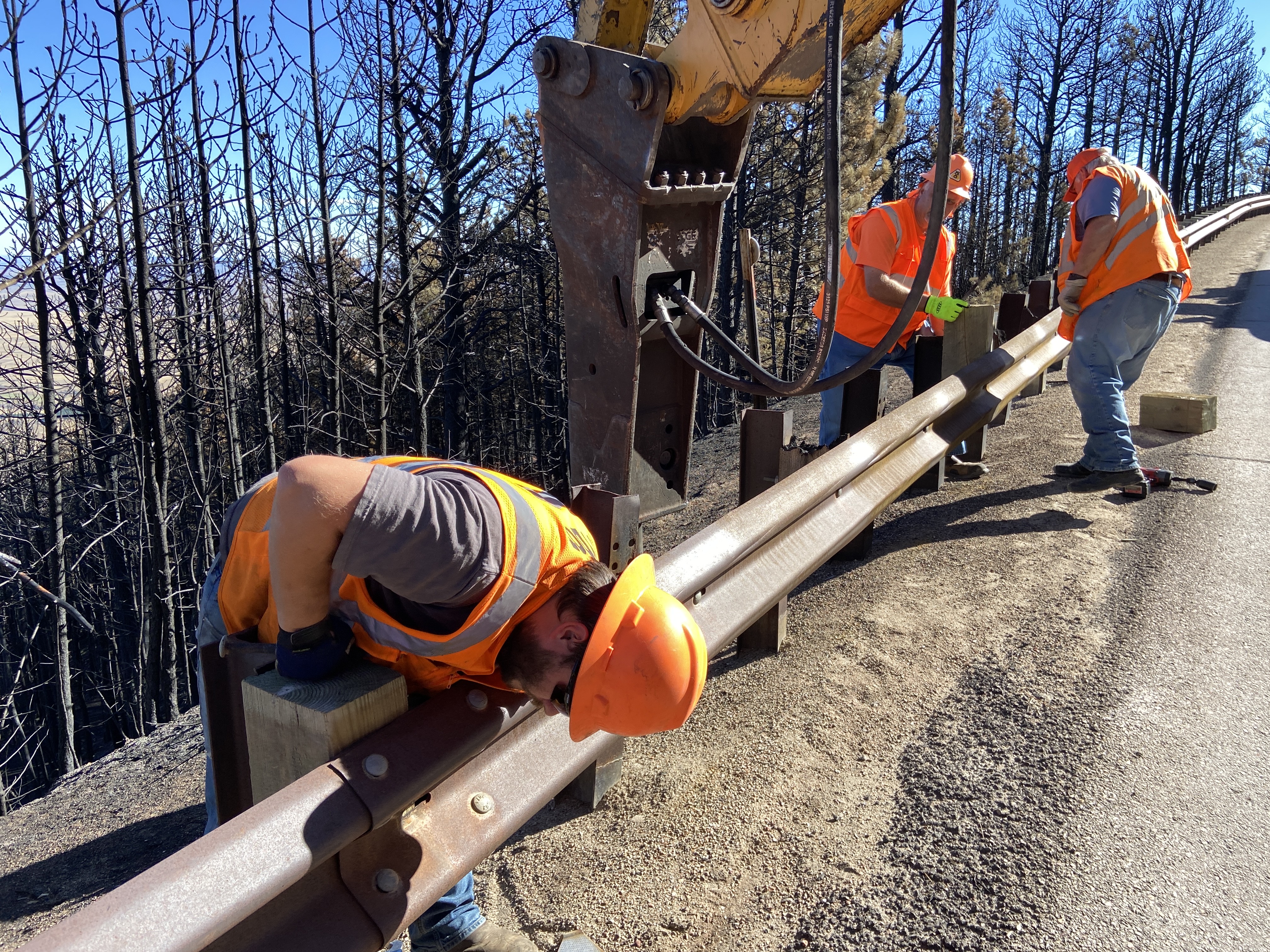
WYDOT to open US 14 – expect delays, reduced speed limit, heavy traffic, and truck restrictions
Sheridan, Wyo—US 14 from Dayton to Burgess Junction has been closed due to the Elk Fire. Recent moisture and containment of over fifty percent have offered some relief to the Sheridan community and the Wyoming Department of Transportation. The road will be opened to traffic on Wednesday, October 23, 2024.
Over the past few weeks, WYDOT District 4 and the Wyoming Highway Patrol have been in constant communication with Incident Command to determine when US 14 would be safe for both fire crews and the traveling public.
Approximately twenty miles of this route received damage to over eight thousand feet of guardrail, thirty signs, and multiple delineators.
After assessing the damage, and determining and procuring the necessary materials and manpower needed to prepare this route for traffic, WYDOT crews exceeded expectations by working diligently on making the necessary repairs in a timely manner, resulting in the ability to open US 14 for the traveling public sooner than expected.
With the opening of US 14 between Dayton and Burgess Junction, motorists should expect a reduced speed limit of 30 MPH, lane closures, flagging operations, pilot cars, increased patrol presence, and maintenance activity within the fire zone.
With the exception of authorized Elk Fire equipment, WYDOT has placed a No Truck Restriction on this route.
WYDOT appreciates the traveling public for their patience and understanding during this difficult time and asks motorists to be mindful of the road conditions, changing weather, and the potential of increased traffic while navigating this route are encouraged to use the designated pullouts for any stopping or photo opportunities.
The Bighorn National Forest closure boundaries and road closures remain in place and will be enforced. Cabin owners are asked to contact their permit administrator regarding access.
##
All Garden Fire Evacuation Zones Rescinded 10 23 2024
Related Incident:
Publication Type: Announcement
All Garden Fire Evacuation Zones Rescinded
THERE HAVE BEEN CHANGES TO THE EVACUATION ZONES, THEY ARE AS FOLLOWS:
ZONE 1 – HAS BEEN RESCINDED
ZONE 2 – HAS BEEN RESCINDED
ZONE 3 – RESCINDED
Zone 1: From Cove Creek to Ebeneezer Bar, downriver along the Salmon River Road #030.
Zone 2: On Panther Creek Rd #055, a half mile south of Beaver Creek Rd #057 to the Salmon River Rd #030 confluence.
Zone 3: Panther Creek to Spring Creek to include private land up Spring Creek.
Pack Trail Daily Update October 23 2024 10 23 2024
Related Incident:
Publication Type: News
Total Acres: 89,639
Confined: 66%
Total Personnel: 551
Operations – On the north side of the Pack Trail Fire, crews work to complete fire suppression repair where there is little fire activity. On the east flank, crews will assess and improve confinement lines along the 540 Road and the Lava Burn Scar connecting to natural features on Lava Mountain. On the fire’s southern end, crews continue working from the Strawberry Warming Hut area to Buffalo Meadows, securing the fire’s edge. On the western flank, crews work to connect confinement lines from Buffalo Meadows along Bacon Creek up to Elk Track Ranch. The forecast for gusty winds today may challenge
firefighters as they work to harden the fire perimeter; snags created by the pine bark beetle and further weakened by the fire may pose a threat to firefighter safety.
Safety – Despite the recent precipitation, Teton Interagency Fire Managers are maintaining the Very High Fire Danger Rating for Grand Teton National Park, the Bridger-Teton National Forest, the Shoshone National Forest, and the National Elk Refuge. This precipitation was not a fire season-ending event. Due to wind, fuels will begin to rapidly dry out when the snow melts. Any spark can ignite a fire which can grow rapidly into a major incident. Residents and visitors are reminded to exercise extreme caution with fires or other possible ignition sources. Follow local regulations regarding outdoor burning and fireworks.
Please use caution while driving in these areas, especially on narrow secondary roads. Always expect to encounter fire vehicles and heavy equipment in and around the fire area. Check with WY-DOT for possible closures due to fire activity, especially if you are planning to travel on US-26 across the Continental Divide. Closures are not expected, but with active fire in the area checking status before travel is recommended.
“If you fly, we can’t.” Remember that flying a personal drone over a fire area during a temporary flight restriction is illegal and can be an extremely dangerous threat to both our aviators and firefighters on the ground.
Weather – Today will be partly to mostly cloudy with temperatures of 50-55 degrees with minimum relative humidity’s between 25% - 30%. Winds from the southwest to the west will be 9-14 MPH with gusts up to 29. A cold front will bring increased cloud cover and a chance for precipitation over the next few days. Rain or snow showers are likely with snow levels lowering to 7,000 – 7,500 ft. To learn more about air quality, visit Fire.AirNow.Gov.
Evacuations – Lava Mountain Lodge, Roaring River Subdivision, Buckboard Subdivision, Double Bar J Ranch, Lava Creek Ranch, Triangle C Ranch, Pelham Lake, Sheridan Creek Camp Areas, Old Mackenzie Ranch, Upper Gros Ventre, Darwin Ranch have been reduced to Level 2 “Set” status. Brooks Lake Lodge, Pinnacle, Breccia, and Long Creek, and Dunior areas have been reduced to a Level 1 “Ready” status. Union Pass subdivision remains in a Level 2 “Set” status. See the Fremont County Emergency Management Facebook Page for alerts and updates. See the Teton County Emergency Management website updates and to sign up for emergency alerts through Everbridge.
Road Closures – The Union Pass Road is closed on the Pinedale Ranger District (BTNF) from Mosquito Lake to the Moon Lake Road on the Wind River District (SHO). Moon Lake Road is also closed.
Forest Closures - Closure Order #04-03-24-317 is in effect from October 14, 2024, at 12:00 p.m. through November 15, 2024 at 12:00 a.m. unless rescinded. This order supersedes previous orders, including #04-03-24-316, prohibiting the same or similar acts in the same described area.
For more information, visit: Facebook: USDA Forest Service - Bridger-Teton National Forest, USDA Forest Service - Shoshone National Forest Pack Trail Inciweb: https://inciweb.wildfire.gov/incident-information/wybtf-pack-trail-fire