
Incident Publication
Frog Fire Daily Update Thursday Sept 12 2024 09 12 2024
Related Incident: Frog
Publication Type: News
Frog Fire Statistics:
Size: 2,500 acres
Containment: 0%
Total Personnel: 91
Location: Little Boulder Creek off East Fork
Reported: 9/7/2024
Cause: Lightning
For More Information:
Information Phone: 208-774-3000
Email: SM.FS.sawtoothinfo@usda.gov
InciWeb: https://inciweb.wildfire.gov/incident-information/idstf-frog
Facebook: https://www.facebook.com/sawtoothnationalforest
Current Situation: A significant weather system is moving through the region over the next few days. Prior to the onset of anticipated precipitation, critical fire weather conditions and an increase in fire activity is anticipated. Fire managers employed various aerial resources in an attempt to contain the fire and prevent its spread across Big Boulder Creek. However, due to escalating wind and fire activity, aerial operations were temporarily suspended.
The fire continued to advance northward, eastward, and westward. Numerous structures located along the East Fork drainage and to the north are at risk. The fire has reached Big Boulder Creek, increasing the potential for embers to be carried across the creek and continue moving. Fire managers are actively working to prevent the fire from establishing across the creek and continuing its northward progression.
As the cloud ceiling drops, air resources will be unable to engage due to low clouds and visibility concerns. Weather is expected to improve Friday or Saturday. A Type 3 Team will be taking command of the fire over the next 24 hours.
Weather, Fuels, and Fire Behavior: Thunderstorms over the next 24 hours are expected to bring moisture that will help moderate fire behavior. However, strong outflow winds will accompany that moisture and may present control problems. Red Flag warnings are in effect today with warming and drying conditions beginning Friday and Saturday.
Evacuations:
For evacuation information on the Frog Fire, please see the Custer County Sheriff’s Facebook page at https://www.facebook.com/p/Custer-County-Sheriff-Idaho-61558947312289/ and the Custer County Emergency Management Facebook page at https://www.facebook.com/ccem.idaho
To sign up for Custer County CodeRED emergency notifications, text CUSTER to 99411 or enroll online at https://public.coderedweb.com/CNE/BF28E45537FF .
Closures and Fire Restrictions:
The Frog Fire Area Closure /Forest Order: 0414-04-152 for portions of the Sawtooth National Forest can be found at this site: https://inciweb.wildfire.gov/incident-publication/idstf-frog/frog-fire-closure-09-10-2024
Fire restrictions on federal, state, and private lands may be found at this site: https://www.idl.idaho.gov/fire-management/fire-restrictions-finder/.
Wildfires are a no-fly zone for unauthorized aircraft, including drones. If you fly, we can’t. For more information, visit http://knowbeforeyoufly.org.
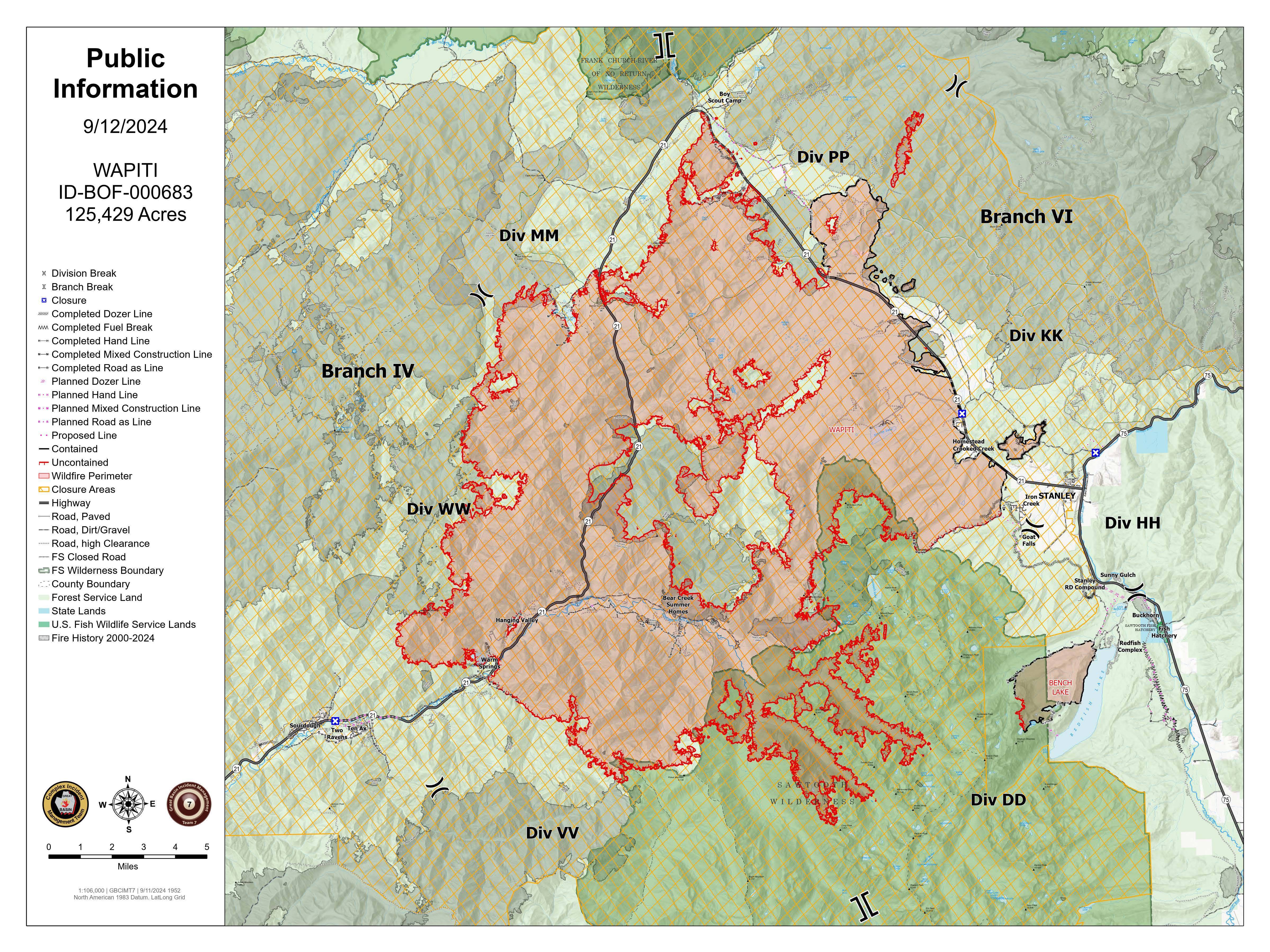
Wapiti Fire Daily Update 09 12 2024
Related Incident:
Publication Type: News
Wapiti Fire Statistics:
Size: 125,429 acres
Containment: 12%
Total Personnel: 1,244
Location: Grandjean, ID
Reported: July 24, 2024
Cause: Lightning
For More Information:
Information Phone: 208-593-7132
Email: 2024.wapiti@firenet.gov
InciWeb: https://inciweb.wildfire.gov/incident-information/idbof-wapiti-fire
Facebook: https://www.facebook.com/wapitifireinfo2024
Linktree: https://linktr.ee/WapitiFireInfo2024
Interactive Map: https://tinyurl.com/WapitiFireInfoMap
Special Notes: State Highway 21 remains closed east of Lowman to Stanley from MP84 (Sourdough Lodge) to MP126 (Stanley Lake turnoff) due to wildfire activity and potential hazards caused by rainfall within the burn area. Highway 75 remains open. A Nevada Type 3 Incident Management Team will in brief today on Frog Fire on the Sawtooth National Forest, for updates on this incident visit the InciWeb page: https://inciweb.wildfire.gov/incident-information/idstf-frog .
Current Situation: Yesterday brought high winds to all areas of the fire ahead of precipitation. Minimal fire activity was observed ahead of the storm front. Today will bring a steady rain, while this will not fully suppress the fire, it will moderate fire behavior. Crews continue to provide protection to various values at risk across the incident. They only engage with the fire where they have a reasonable probability of success. Incident Managers and Agency Administrators from the Forest Service and Idaho Department of Lands continue to meet daily to assess operations and incident objectives.
Division DD: The fire continues to hold within the creek drainages and at the rock scree above the tree line in the Sawtooth Wilderness. Aircraft fly this area of the fire daily, weather permitting, to monitor for hotspots or movement out of the drainages.
Division HH: Crews remain in the Stanley community. Fire lines in the Iron Creek area are holding and crews continue to monitor the division.
Division KK and Structure Group East: Structure protection remains in place and crews monitor the communities to ensure that the fire is not progressing.
Divisions PP & MM: Fire resources maintained a presence along the fire perimeter and continue to monitor the fire along Highway 21. No firing operations were necessary. The area remained fairly quiet through the wind event near Cape Horn and the fire maintained its footprint.
Division WW and Structure Group West: Structure and prep work is complete in Sourdough, Ten Ax, Two Ravens and Middle Lowman. Crews worked to improve lines throughout the communities to prepare for the wind event. Some fire came down above the Warm Spring Guard Station and aviation resources were used to keep the fire from coming down the hill. Fire on Eight Mile Ridge remained in its footprint throughout the wind event. Handline was completed in Eight Mile Creek within an old roadbed from Highway 21 1.5 miles up the canyon. Preparation work is complete on the Jackson Peak Communication Site. Crews assisted with Initial Attack on a single-tree fire near Lowman.
Division VV: Minimal fire activity was observed in this division and the fire continues to hold at Chapman Creek. Due to low potential for fire to spread, aircraft fly this area of the fire daily, weather permitting, to monitor for hotspots or movement out of the drainages.
Weather, Fuels, and Fire Behavior: Yesterday’s storm brought heavy winds, rain and hail. This morning will bring sporadic showers. Temperatures will continue to drop throughout the day and into the evening; low overnight temps will drop into the twenties. Over the next week conditions will continue to cycle between warm/dry and cooler/wet waves.
Evacuations:
For evacuation information on the Wapiti Fire, please see the Custer County Sheriff’s Facebook page at https://www.facebook.com/p/Custer-County-Sheriff-Idaho-61558947312289/ and the Boise County Sheriff’s Facebook page at https://www.facebook.com/boisecountysheriff/.
To sign up for Custer County CodeRED emergency notifications, text CUSTER to 99411 or enroll online at https://public.coderedweb.com/CNE/BF28E45537FF .
To sign up for Boise County Alert Sense emergency notification enroll online at https://public.alertsense.com/SignUp/publicUser.aspx?regionid=1163
Closures and Fire Restrictions:
State Highway 21 remains closed from MP84 to MP126 for public and firefighter safety.
A Wapiti Fire Area Closure / Forest Order: 0414-04-151 for portions of the Boise, Sawtooth, and Salmon-Challis National Forests can be found at this site: https:/www.fs.usda.gov/alerts/sawtooth/alerts-notices.
Boise National Forest Stage 1 Fire Restrictions / Forest Order: 0402-00-63 can be found at this site: https://www.fs.usda.gov/alerts/boise/alerts-notices.
Sawtooth National Forest Stage 1 Fire Restrictions / Forest Order 0414-00-044 can be found at this site: https://www.fs.usda.gov/alerts/sawtooth/alerts-notices
Fire restrictions on federal, state, and private lands may be found at this site: https://www.idl.idaho.gov/fire-management/fire-restrictions-finder/.
Temporary Flight Restriction is in place over the Wapiti Fire. Wildfires are a no-fly zone for unauthorized aircraft, including drones. If you fly, we can’t. For more information, visit http://knowbeforeyoufly.org.
Central Idaho Smoke Outlook 09 12 2024
Related Incident:
Publication Type: News
Special Statement
AIR QUALITY ADVISORIES in effect. See Idaho DEQ for current status.
Fire
Rain fell yesterday and more is expected today on fires in Central and Southwest Idaho. Fire spread will be on "pause" for a few days. However there are still plenty of smoldering stump holes and tree cavities out there which can produce smoke even during a rainstorm. Wildfires in Oregon (a big driver of our air quality this summer) received some rain, but not as much as in Idaho.
Smoke
Conditions will be between GOOD and MODERATE today across the region, except in mountain valleys and drainages closest to the largest fires, where UNHEALTHY FOR SENSITIVE GROUPS will be the likely category. A little more rain in the forecast will help, but the airmass moving in across Oregon still has a hint of smoke in it, making widespread GOOD conditions elusive. A dry weekend will see increased smoldering locally and regionally, with air quality ticking slowly worse. View interactive smoke outlook.
Fish Creek Fire Update Thursday 09 12 2024
Related Incident:
Publication Type: News
Fish Creek Fire Update: Thursday, September 12, 2024
Northern Rockies Team 2, Incident Commander Scott Schuster
Location: 7 miles SW of Togwotee Pass
Start Date: Friday, August 16, 2024
Cause: Lightning
Size: 24,904
Percent complete: 69%
Resources: 465 Total Personnel: 9 Hand Crews; 23 Engines; 11 Heavy Equipment; 3 Helicopters
KEY MESSAGES:
The rain that has fallen, and the higher humidity levels, has resulted in minimal fire activity yesterday. Minimal fire activity is expected again today and tomorrow with the rain still in the forecast. Air quality has improved with the rain that has fallen and the incoming cold front. Smoke will continue to impact the Highway 26/287 corridor and the immediate area around the fire. Roadway visibility may be impacted by the smoke from the fire; please slow down and use caution when driving Highway 26/287.
Fremont County has decreased the “GO – Level 3” Evacuation Order to the “SET – Level 2” Notice for the Brooks Lake, Pinnacle, and Breccia areas. These areas are still within Forest closures, so access to Brooks Lake, Pinnacle, and Breccia areas will be reevaluated next week. Residents are advised to monitor the situation, as there is still the possibility evacuations may once again be ordered if conditions worsen.
CURRENT STATUS:
Fire monitoring continues for any potential threats to Highway 26 and other critical values. Mechanical and hand clean-up work along Deception Road from Highway 26 to Brooks Lake Lodge campground is continuing. The moderating weather and minimal fire behavior has allowed resources to begin work on a shaded fuel-break along a 2-mile stretch of the Upper Flagstaff Road. This work includes clearing the understory vegetation and smaller trees for 50’ to 100’ on each side of the road. Firewise work is taking place around the Togwotee Lodge to ensure better fire protection from the Fish Creek Fire or future wildfires and is expected to continue through the beginning of next week. The Cottonwood Creek area continues to generate the greatest fire behavior.
WEATHER AND FIRE BEHAVIOR:
Scattered showers and thunderstorms will continue today. Outflow winds from the thunderstorms can be gusty and erratic. Rainfall totals of up to 0.5 inch are predicted. A cold front will make its way through the area today, dropping the temperatures through Friday. High temperatures will be in the 40s during the day today, and freezing temperatures are possible tonight and tomorrow night. The moderating weather conditions will reduce active fire behavior.
AIR QUALITY AND SMOKE:
Although air quality has improved, unhealthy air quality is possible in locations, especially in low-lying drainages and along the Highway 26/287 corridor. For up-to-date air quality alerts, current and predicted smoke conditions and ways to mitigate poor air quality, check out the AirNow website at https://www.airnow.gov/.
CLOSURES AND EVACUATIONS:
The joint Closure Order issued by both the Bridger-Teton and Shoshone National Forests for the fire area, remains in effect. Please do not enter the closure area or use any Forest Roads that are closed. For specific details regarding this closure, please reference the Fish Creek Area, Roads, and Trails Closure Order (map) and the Forest website at https://www.fs.usda.gov/alerts/btnf/alerts-notices.
Under the jurisdiction of Fremont County, the areas of Brooks Lake, Pinnacle Drive and Breccia Drive have decreased to Level 2 “Set” Notice (indicated by yellow blocks on the PIO Incident Map). A Level 2 “Set” Notice means residents should be ready to evacuate at a moment’s notice. If the Level 2 Set notice changes back to a Level 3 “Go” notice, residents must evacuate until advised otherwise by Fremont County. See the alert notice on the Fremont County Fire Protection District Facebook page.
The Teton County Division of Emergency Management utilizes a Ready, Set, Go system for evacuation messaging, visit their website for additional details at www.tetoncountywy.gov/1846/Ready-Set-GO. (Indicated by green blocks on the PIO Incident Map.) They advise all residents to be in a “Ready” status by preparing for evacuations and becoming fire adapted. All residents are encouraged to sign up for Teton County, Wyoming's free alert and warning service, Teton_WY Alerts at: Teton_WY Alerts - Sign Up (everbridge.net).
US HWY 26/287 is open for free-flowing traffic. Motorists may still experience smoke and sometimes limited visibility. A 45-mph speed restriction remains in effect for the fire area. Motorists are encouraged to stay alert for fire personnel and fire vehicles and use caution when travelling through the area. The Wyoming Department of Transportation (WYDOT) continues to work closely with Fremont County Emergency Management, Fremont County Sheriff’s Office and fire officials for the safety of motorists and firefighters. Drivers are encouraged to visit https://www.wyoroad.info/ prior to traveling on US HWY 26/287 for road status and information, or download the Wyoming 511 app at https://www.wyoroad.info/511/WY511Mobile.html to monitor for any changes due to fire activity.
Moore Square Complex Fire Update 09 12 2024
Related Incident:
Publication Type: Announcement
Key Messages
Crews have completed indirect line construction and continue Point Protection for the values at risk. Favorable weather and wetting rain are expected over the entire perimeter of the fire in the coming days and fire activity is expected to moderate with the changing weather conditions. The closure order remains in place as we continue to experience fire activity around the entire perimeter of the fire at this time.
Current Status
Heavy equipment is nearing completion of road prep for an internal containment feature to help slow the spread of fire if firing operations were to be implemented. Crews continue to focus on the identified values at risk. Point Protection is in place around these values at risk and values that have not been impacted by fire are likely to see minimal impacts from the fire in the coming days. Heavy rain and cooler temperatures are forecasted over the fire area through the weekend. Cooler weather does not mean the threat of fire has lessened, fire fighters are still seeing growth on all sides of the fire and the potential for movement remains.
Closures
The closure area around the fire remains in place. Access to the area around the fire is closed to the public until the order is rescinded. As hunting units within the fire area become open for the season we urge hunters to honor the closure area, not only for their safety but for the safety of fire fighters working on the Moore Square Complex.
Specific closure information and maps can be found on Inciweb at https://inciweb.wildfire.gov/incident-information/idncf-moore-square-complex and https://www.fs.usda.gov/detail/nezperceclearwater/home/?cid=fsm91_055753 as they are implemented.
**Future updates for the Moore Square Complex will continue as fire activity and events warrant it.**
Daily Update for the Chimney Fire 09 12 2024
Related Incident: Chimney Fire
Publication Type: News
Precipitation moderates fire activity on Chimney Fire
Daily Update – Thursday, September 12, 2024
Acres: 6,475
Start Date: 9/2/2024
Location: 9 miles northwest of Fairfield, ID
Personnel: 457
Containment: 10%
Fuels: Timber, brush, grass, understory
Highlights: Community meeting will be held tonight at 6 pm at the Camas County Senior and Community Center at 129 Willow Avenue in Fairfield, Idaho.
Operations: Firefighters added containment on the southern perimeter to keep the fire from moving across the Lime Creek drainage and to protect values at risk. A reconnaissance flight detected a spot fire on the northern section of the fire that grew to 40 acres by the afternoon. Fire growth is pushing northeast towards a significant natural feature, Rock Ridge, that could help to hold the fire. Crews scouted access roads and planned for future work along the eastern and western flanks. Today’s activities will be weather dependent; if the roads are passable and safe for crews to continue scouting routes, cleanup work will continue on the proposed bulldozer line. With anticipated high relative humidity at a minimum of 53, minimal fire activity expected today. Heat is expected to remain in heavy dead and down timber, despite the expected weather pattern.
Weather: Rain showers are expected to continue through Thursday afternoon, producing an expected rainfall total of 0.10 to 0.60 of an inch of rainfall. This autumn storm will keep high temperatures mainly 45 to 55 degrees on Thursday afternoon. Humidity will run very high, staying above 45 percent everywhere. With clearing skies Thursday night lows should be in the 30s, including locations below the freezing mark.
Smoke: Smoke may be visible from the Fairfield area, with much improved air quality predicted today. An interactive smoke map located at https://fire.airnow.gov/ allows you to zoom into your area to see the latest conditions.
Closures: The Sawtooth National Forest has issued an emergency temporary closure of trails and trail segments for the Chimney Fire. The purpose of the closure order is for the protection of firefighters and public during wildfire suppression activities occurring in and around the trails. The full closure order (No. 0414-05-065) and map are available on the Sawtooth National Forest website at https://www.fs.usda.gov/alerts/sawtooth/alerts-notices.
Safety: The health and safety of firefighters and the public are always the first priority. A temporary flight restriction (TFR) is in place over the area, which includes uncrewed aircraft or drones. Flying drones near wildfires is dangerous for pilots and firefighters and can bring wildfire suppression efforts to a halt. Know before you fly. If you fly, we can’t. More information can be found at: https://uas.nifc.gov/.
More Information: https://inciweb.wildfire.gov/incident-information/ideix-chimney-fire /
208-246-8292 / https://www.facebook.com/sawtoothnationalforest / 2024.chimney@firenet.gov / https://www.facebook.com/IdahoDepartmentofLands/
Devils Knob and Milepost 98 Fires Evening Update 09 11 2024
Related Incident:
Publication Type: News
Devil’s Knob and Milepost 98 Fire Evening Update for Wednesday, September 11, 2024
KEY MESSAGES:
A public meeting was held tonight in Tiller. This meeting was recorded and will be posted to the Facebook page for viewing.
CURRENT STATUS:
Devil’s Knob - Resources: 657, Crews: 19, Engines: 16, Water Tenders: 12
Night operations will build on what firefighters were able to accomplish today. This includes continuing to secure and bolster lines around the fire. Hand crews will monitor hot spots near the fire’s edge and engage where able to fully extinguish fuels. Weather may impact the work that resources can accomplish tonight, however progress will push forward with firefighter safety taken into consideration.
Milepost 98- Resources: 325, Crews: 13, Engines: 12, Water Tenders: 9
Firefighters have finished building line around the entirety of the Milepost 98 fire. Resources assigned to the fire tonight will continue mop-up operations, broadening lines and further securing the perimeter. Hazard trees that could fall in wet and windy weather are a concern on the line tonight. Firefighters will be aware of this potential and mitigate these risks as they work tonight.
WEATHER / FIRE BEHAVIOR:
Fire behavior will be minimal this evening after the cold front that moved through the region Wednesday. Wetting rains of 1/10 of an inch fell within the fire area. Isolated showers will remain on Thursday with seasonal temperatures and high humidly.
SAFETY AND CLOSURES:
There are two closures impacting every district of the Umpqua National Forest, including a new closure for the Devil’s Knob Fire. These can be found at https://www.fs.usda.gov/alerts/umpqua/alerts-notices. While all lanes on I-5 are open between Milepost 97 and 98, the right shoulder remains closed for firefighter safety. Please use extra caution when driving due to the wet weather, which also includes increased potential for rollout debris in areas impacted by wildfire.
Restrictions for the Douglas Forest Protective Association have decreased. Industrial Fire Precaution Levels (IFPL) have decreased to IFPL LEVEL 2 on all lands protected by the Douglas Forest Protective Association, which includes lands managed by the Bureau of Land Management (BLM). Public Use Restrictions (PURs) have decreased to MODERATE for all private, county, state, and Bureau of Indian Affairs lands within the Douglas District, which imposes certain fire restrictions on the public to help prevent wildfires.
Evacuation levels from the Douglas County Sheriff’s Office have changed. An interactive map can be found at their website, https://www.dcso.com/EVACUATIONS. Residents are encouraged to sign up for emergency notifications through Douglas County Emergency Management, found at https:// www.dcso.com/254/Emergency-Notification-System. Currently, no level 3 evacuations exist. Level 2 evacuations include all residences on Joe Hall Road, all residences on Tison Road, all residences on Elk Diamond Road, and all residences on Ritchie Road. Level 1 evacuations include all residences on the East side of Tiller Trail Hwy between the 34000 to 36760 block. Cancelled evacuation notices include all residential addresses on Canyon Creek Road.
Linton Creek Fire Area Closure 09 10 2024
Related Incident: North Willamette Complex
Publication Type: Closures
The Willamette National Forest has issued a Forest Area Closure primarily within the Three Sisters Wilderness Area due to the Linton Creek Fire. The fire is within the wilderness, which requires different firefighting tactics than a front-country / road accessible fire.
Please respect the Closure, they keep you safe and allow firefighter to do their job of getting the fire under control.
Bridge Fire Evening Update 09 11 2024
Related Incident: Bridge Fire
Publication Type: News
Unified Command: CIIMT5, Los Angeles County Fire, Los Angeles County Sheriff, San Bernardino County Fire, San Bernardino County Sheriff, CAL FIRE – San Bernardino/Inyo/Mono Unit
Incident Website:
inciweb.wildfire.gov/incident-information/caanf-bridge-fire
Fire Information: (626) 662-0120
Hours: 8:00 a.m. to 8:00 p.m.
Email: 2024.Bridge@firenet.gov
Fire Size: 49,075 acres
Percent Contained: 0%
Personnel: 408
Cause: Under investigation
Start Date: Sunday, September 8, 2024, at 2:12 p.m.
Location: Sheep Mountain Wilderness, Angeles National Forest
CURRENT SITUATION: Today the Bridge Fire was still active, however, the behavior moderated significantly due to the slight increase in humidity and decrease in temperatures. Firefighters were able to make great progress on the ground aided by aircraft to attack the fire aggressively 24-hours per day. Crews continued to be engaged with structure defense in the communities of Wrightwood, Piñon Hills, and Mount Baldy. The ability for crews to also extinguish new fire starts in the vicinity of the Bridge Fire is also a good sign and testament to their success and hard work.
The north side of the fire remained the most active. However, more favorable weather conditions aided firefighters in gaining the upper hand on holding the fire on the south side of Highway 2. Top priorities for firefighters remained in structure protection and defense of the communities nearby with dozer line construction and pre-treating containment lines with fire retardant.
On the east side, firefighters were able to directly engage as the fire behaved favorably, backing and flanking slowly down to Mount Baldy Road. Firefighters continue to hold the fire on the west side of this road and continue structure protection efforts in the communities of Mount Baldy Village, including the Icehouse Canyon area.
To the south, firefighters were successful in reinforcing containment lines and scouted to reopen old dozer lines for contingency planning. Front-country communities currently under an evacuation warning will see dozers and fire personnel working on the south flank of the fire to construct these contingency lines and protect the communities below it. A five-acre spot fire near Sunset Peak was also successfully suppressed with direct attack.
On the west side of the fire, containment lines are holding and firefighters are engaged in mop up, checking the area for hotspots and extinguishing them. There is minimal growth and moderated fire behavior in this area.
Evacuation Orders:
- Highway 138 south to Lone Pine Canyon and Highway 2 east to Lone Pine Canyon Road.
- Piñon Hills from Wrightwood north to Highway 18 and Beekley Road west to Los Angeles County.
- Lone Pine Canyon from the community of Wrightwood to Highway 138/Lone Pine Canyon Road south to the Forest.
- Entire community of Wrightwood.
- East Fork communities of Camp Williams Resort (café, mobile home park, campground) and River Community (near the resort).
- Mt. Baldy Road, all residents north of the San Antonio Dam up to the Mt. Baldy Resort.
Evacuation Warnings:
- The area of Phelan from Highway 138 east to Baldy Mesa Road and Phelan Road south to Sayle Road.
- San Antonio Heights and Upland from the foothills south to 23rd Street.
- Piñon Hills from Wrightwood north to Highway 138 and Lebec Road west to Los Angeles County.
Evacuation Centers:
- San Bernardino County Fairgrounds: 14800 Seventh Street, Victorville, CA 92392
- Jessie Turner Health and Fitness Community Center: 15556 Summit Ave, Fontana, CA 92336. Call (909) 854-5100
- Pomona Fairplex: 601 W McKinley Avenue, Pomona, CA 91768 (Enter Gate 3, corner of McKinley and White)
- Animals:
- Devore Animal Shelter: 19777 Shelter Way, San Bernardino, CA 92407. Call (909) 386-9820, or after hours: (800) 472-5609
- Palmdale Animal Care Center (Small Animals): 38550 Sierra Highway, Palmdale, CA 93550
- Lancaster Animal Care Center (Small Animals): 5210 W Ave I, Lancaster, CA 93536
- Antelope Valley Fairgrounds (Large Animals): 2551 W Avenue H, Lancaster, CA 93536. Call 562-706-8581 prior to arrival.
For more information on shelters, visit:
- www.redcross.org/get-help/disaster-relief-and-recovery-services/find-an-open-shelter.html
- https://lacounty.gov/emergency/
- If not already registered for emergency alerts, please register for them here:
CLOSURES:
- SR-138 from Lone Pine Canyon Road to Beekley Road
- SR-2 closed from Big Pines to SR-138.
- San Gabriel Canyon and East Fork of the San Gabriel River
- Highway 39
- East Fork Road
- Glendora Ridge Road
- Glendora Mountain Road
- Mt. Baldy Road at Shinn Road intersection
WEATHER:
Red Flag Warning highlighting imminent critical fire weather patterns was extended until 10:00 a.m. tomorrow, however, conditions should improve thereafter. There will be increased stability in weather with lower temperatures and higher humidity, allowing firefighters to make good progress on their suppression efforts.
Exposed ridges at higher elevations will have higher wind speeds than the lower valley and canyon areas, which is where active fire behavior and higher flame lengths will continue to be most visible.
For information on smoke impacts and an interactive map, visit fire.airnow.gov.
Fossil Complex Evening Update 09 11 2024
Related Incident: Fossil Complex
Publication Type: News
Rain and Cooler Weather Helps Crews Make Progress
SPRAY, Ore. – Showers and cooler weather over the fires helped slow growth and allowed crews to make progress around the fires. The northwest to north side of the fire now has direct line and mop up operations have started. On the southwest side along ORE 19, crews will be focusing on removing hazard trees to allow mop up, which will allow opening of the highway.
The community meeting in Fossil was attended by over 40 people. ODF Incident Commander Matt Howard, along with ODF Operations, ODF John Day Unit, Oregon State Fire Marshall and the Wheeler County Fire Defense Board Chief addressed the attendees and answered questions.
The Wheeler County Sheriff’s Office continually evaluates evacuation levels. Please check their Facebook page for the latest information. https://www.facebook.com/WheelerCountySheriffsOffice/
The Two Cabin, Holmes, Kinzua and Canyon Fires are all in patrol status.
Community Meeting:
Spray: Due to the closure of ORE19, a public meeting in Spray is planned for Thursday 12th at The Rock, 601 Willow St. at 6:30 PM.
Flying unauthorized drones is hazardous to aircraft and will ground critical aerial operations.
FIRE AT A GLANCE
Fossil Complex
Total Size: 22,439 acres
Two Cabin-251acres
Canyon-190 acres
Kinzua-96 acres
Holmes-15 acres
Service- 21,887
Containment: 3%
Cause: Lightning
Current Cost: $9.8 M
All Resources
Hand Crews: 40
Engines: 58
Water Tender: 16
Dozers: 20
Skidders: 7
Skidgen: 3
Excavator: 2
Masticator: 2
Feller Buncher: 4
Total Resources: 1,255
Aerial Resources
Type 1: 3
Type 2: 6
Type 3: 4
Evacuations:
Level 1: 21 addresses
Level 2: 85 addresses
Level 3: 156 addresses
https://www.facebook.com/WheelerCountySheriffsOffice/
ODF Incident Commander:
Matt Howard, Incident Commander
Incident Management Team 2