
Air Quality and Smoke Summary for Friday September 11 2020
Related Incident:
Publication Type: News
Air quality and smoke summaries can be found below.
Complete smoke outlook and can be found here - https://fires.airfire.org/outlooks/columbia_river_gorge_or_wa
Daily Update for Friday September 11 2020
Related Incident:
Publication Type: News
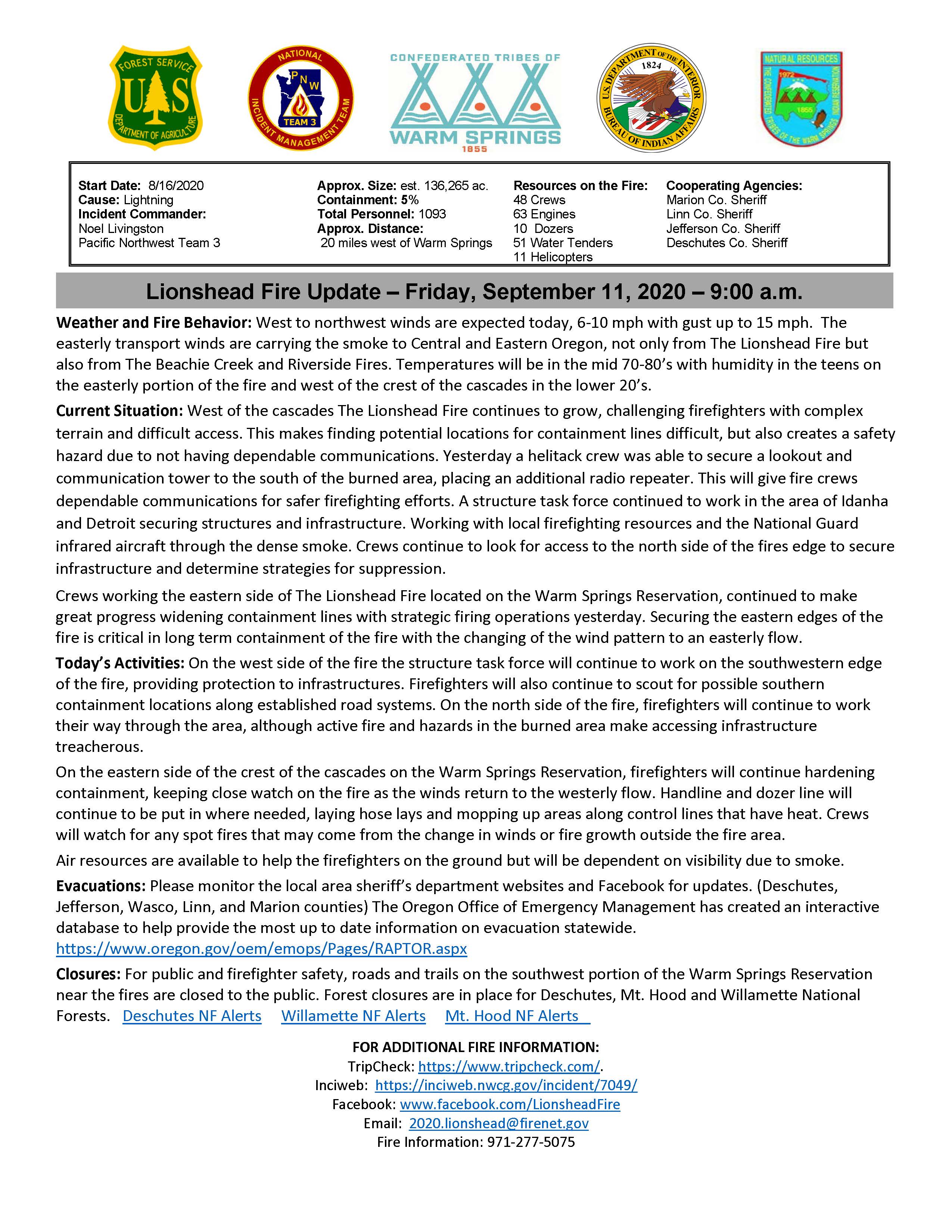
Start Date: 8/16/2020
Cause: Lightning
Incident Commander: Noel Livingston, Pacific Northwest Team 3
Approximate Size: 136,265 acres
Containment: 5%
Total Personnel: 1093
Approximate Distance: 20 miles west of Warm Springs
Resources on the Fire:
48 crews
63 engines
10 dozers
51 water tenders
11 helicopters
Cooperating Agencies:
Marion County Sheriff
Linn County Sheriff
Jefferson County Sheriff
Deschutes County Sheriff
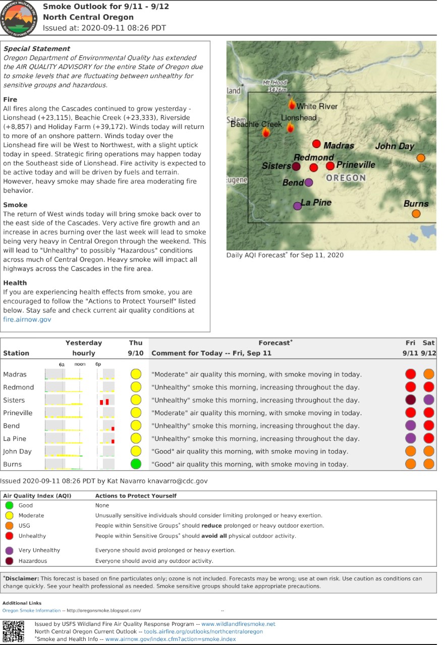
Weather and Fire Behavior: West to northwest winds are expected today, 6-10 mph with gust up to 15 mph. The easterly transport winds are carrying the smoke to Central and Eastern Oregon, not only from The Lionshead Fire but also from The Beachie Creek and Riverside Fires. Temperatures will be in the mid 70-80’s with humidity in the teens on the easterly portion of the fire and west of the crest of the cascades in the lower 20’s.
Current Situation: West of the cascades The Lionshead Fire continues to grow, challenging firefighters with complex terrain and difficult access. This makes finding potential locations for containment lines difficult, but also creates a safety hazard due to not having dependable communications. Yesterday a helitack crew was able to secure a lookout and communication tower to the south of the burned area, placing an additional radio repeater. This will give fire crews dependable communications for safer firefighting efforts. A structure task force continued to work in the area of Idanha and Detroit securing structures and infrastructure. Working with local firefighting resources and the National Guard infrared aircraft through the dense smoke. Crews continue to look for access to the north side of the fires edge to secure infrastructure and determine strategies for suppression.
Crews working the eastern side of The Lionshead Fire located on the Warm Springs Reservation, continued to make great progress widening containment lines with strategic firing operations yesterday. Securing the eastern edges of the fire is critical in long term containment of the fire with the changing of the wind pattern to an easterly flow.
Today’s Activities: On the west side of the fire the structure task force will continue to work on the southwestern edge of the fire, providing protection to infrastructures. Firefighters will also continue to scout for possible southern containment locations along established road systems. On the north side of the fire, firefighters will continue to work their way through the area, although active fire and hazards in the burned area make accessing infrastructure treacherous.
On the eastern side of the crest of the cascades on the Warm Springs Reservation, firefighters will continue hardening containment, keeping close watch on the fire as the winds return to the westerly flow. Handline and dozer line will continue to be put in where needed, laying hose lays and mopping up areas along control lines that have heat. Crews will watch for any spot fires that may come from the change in winds or fire growth outside the fire area.
Air resources are available to help the firefighters on the ground but will be dependent on visibility due to smoke.
Evacuations: Please monitor the local area sheriff’s department websites and Facebook for updates. (Deschutes, Jefferson, Wasco, Linn, and Marion counties) The Oregon Office of Emergency Management has created an interactive database to help provide the most up to date information on evacuation statewide. https://www.oregon.gov/oem/emops/Pages/RAPTOR.aspx
Closures: For public and firefighter safety, roads and trails on the southwest portion of the Warm Springs Reservation near the fires are closed to the public. Forest closures are in place for Deschutes, Mt. Hood and Willamette National Forests. Deschutes NF Alerts Willamette NF Alerts Mt. Hood NF Alerts
FOR ADDITIONAL FIRE INFORMATION:
TripCheck: https://www.tripcheck.com/.
Inciweb: https://inciweb.nwcg.gov/incident/7049/
Facebook: www.facebook.com/LionsheadFire
Email: 2020.lionshead@firenet.gov
Fire Information: 971-277-5075
Daily Update for Thursday September 10 2020
Related Incident:
Publication Type: News
Quick Facts - Fire Summary
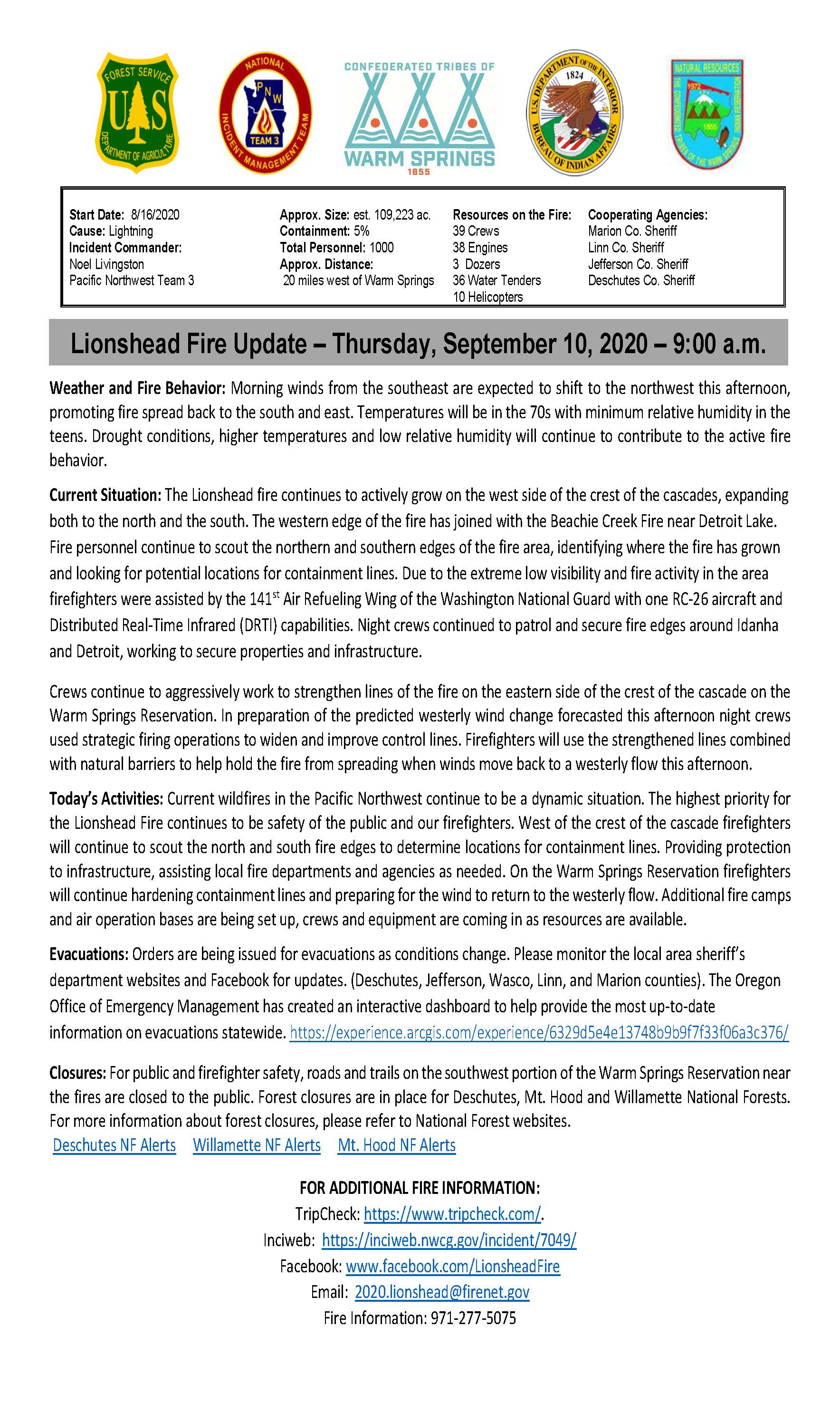
Start Date: 8/16/2020
Cause: Lightning
Incident Commander: Noel Livingston, Pacific Northwest Team 3
Approximate Size: 109,223 acres
Containment: 5%
Total Personnel: 1000
Approximate Distance: 20 miles west of Warm Springs
Resources on the Fire:
39 crews
38 engines
3 dozers
36 water tenders
10 helicopters
Cooperating Agencies:
Marion County Sheriff
Linn County Sheriff
Jefferson County Sheriff
Deschutes County Sheriff
Lionshead Fire Update – Thursday, September 10, 2020 – 9:00 a.m.
Weather and Fire Behavior: Morning winds from the southeast are expected to shift to the northwest this afternoon, promoting fire spread back to the south and east. Temperatures will be in the 70s with minimum relative humidity in the teens. Drought conditions, higher temperatures and low relative humidity will continue to contribute to the active fire behavior.
Current Situation: The Lionshead fire continues to actively grow on the west side of the crest of the cascades, expanding both to the north and the south. The western edge of the fire has joined with the Beachie Creek Fire near Detroit Lake. Fire personnel continue to scout the northern and southern edges of the fire area, identifying where the fire has grown and looking for potential locations for containment lines. Due to the extreme low visibility and fire activity in the area firefighters were assisted by the 141st Air Refueling Wing of the Washington National Guard with one RC-26 aircraft and Distributed Real-Time Infrared (DRTI) capabilities. Night crews continued to patrol and secure fire edges around Idanha and Detroit, working to secure properties and infrastructure.
Crews continue to aggressively work to strengthen lines of the fire on the eastern side of the crest of the cascade on the Warm Springs Reservation. In preparation of the predicted westerly wind change forecasted this afternoon night crews used strategic firing operations to widen and improve control lines. Firefighters will use the strengthened lines combined with natural barriers to help hold the fire from spreading when winds move back to a westerly flow this afternoon.
Today’s Activities: Current wildfires in the Pacific Northwest continue to be a dynamic situation. The highest priority for the Lionshead Fire continues to be safety of the public and our firefighters. West of the crest of the cascade firefighters will continue to scout the north and south fire edges to determine locations for containment lines. Providing protection to infrastructure, assisting local fire departments and agencies as needed. On the Warm Springs Reservation firefighters will continue hardening containment lines and preparing for the wind to return to the westerly flow. Additional fire camps and air operation bases are being set up, crews and equipment are coming in as resources are available.
Evacuations: Orders are being issued for evacuations as conditions change. Please monitor the local area sheriff’s department websites and Facebook for updates. (Deschutes, Jefferson, Wasco, Linn, and Marion counties). The Oregon Office of Emergency Management has created an interactive dashboard to help provide the most up-to-date information on evacuations statewide. https://experience.arcgis.com/experience/6329d5e4e13748b9b9f7f33f06a3c376/
Closures: For public and firefighter safety, roads and trails on the southwest portion of the Warm Springs Reservation near the fires are closed to the public. Forest closures are in place for Deschutes, Mt. Hood and Willamette National Forests. For more information about forest closures, please refer to National Forest websites.
Deschutes NF Alerts Willamette NF Alerts Mt. Hood NF Alerts
FOR ADDITIONAL FIRE INFORMATION:
TripCheck: https://www.tripcheck.com/.
Inciweb: https://inciweb.nwcg.gov/incident/7049/
Facebook: www.facebook.com/LionsheadFire
Email: 2020.lionshead@firenet.gov
Fire Information: 971-277-5075
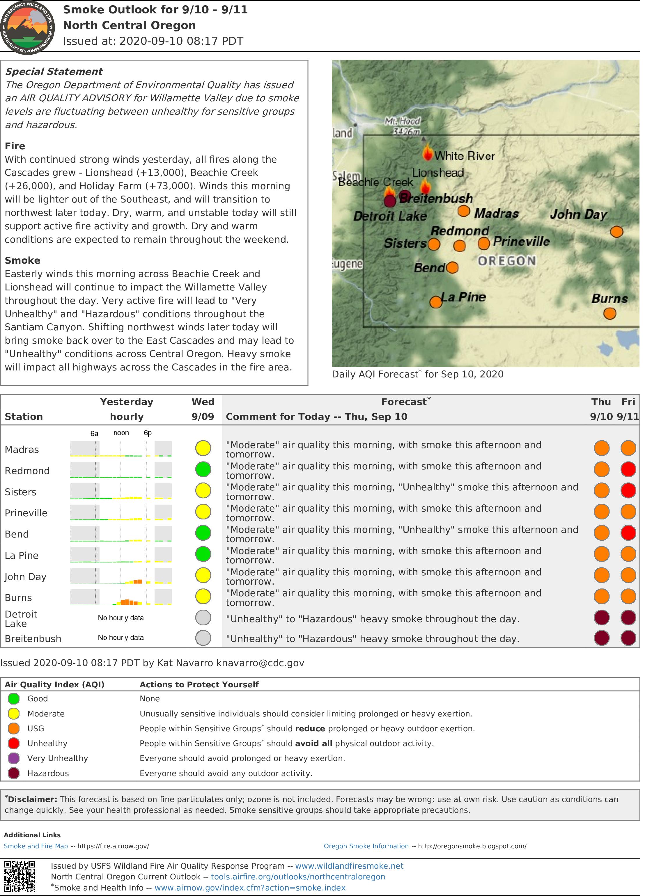
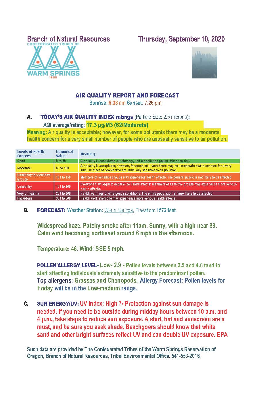
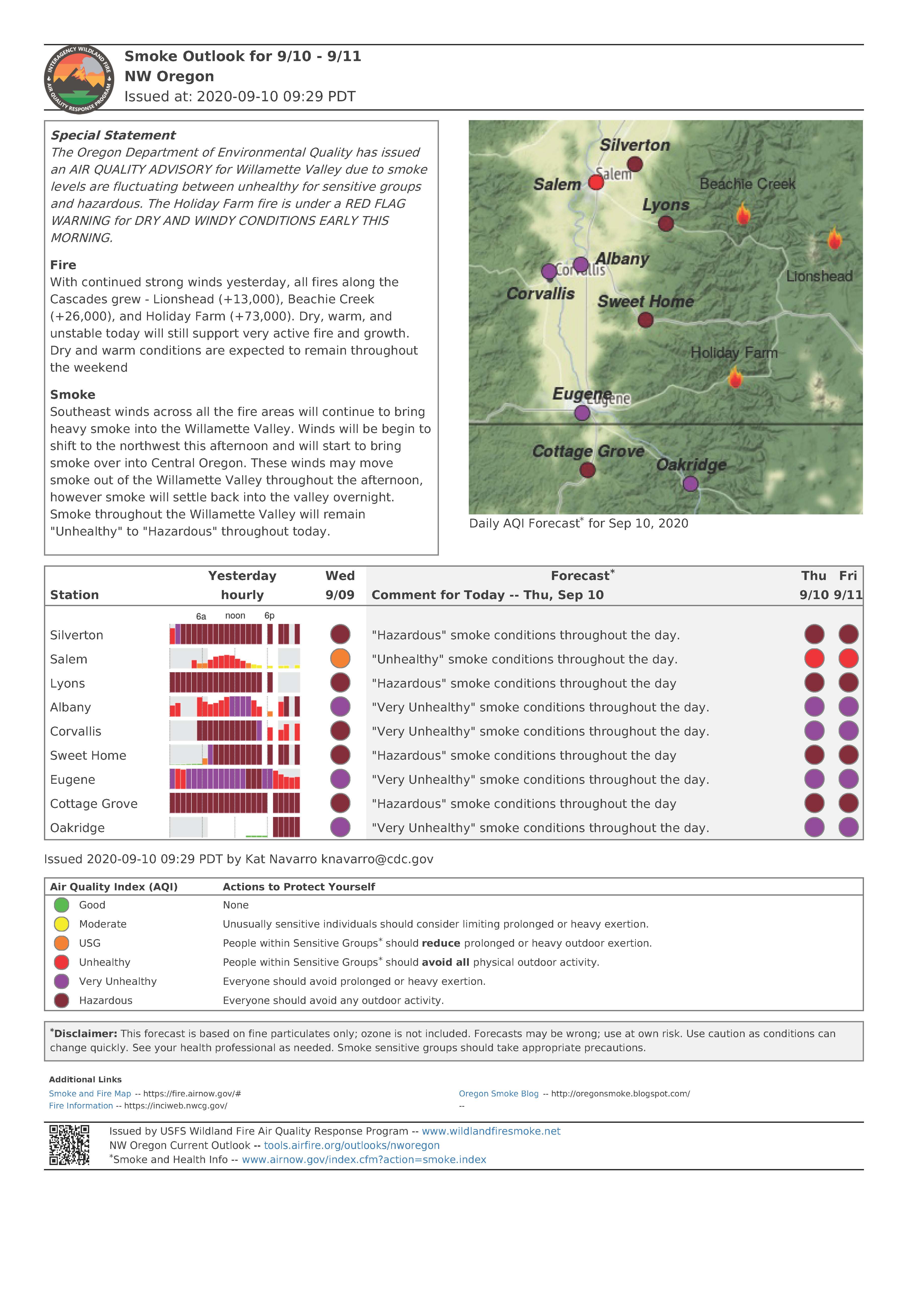
Air Quality Reports for Thursday September 10 2020
Related Incident:
Publication Type: News
Today's smoke outlook reports are attached below.
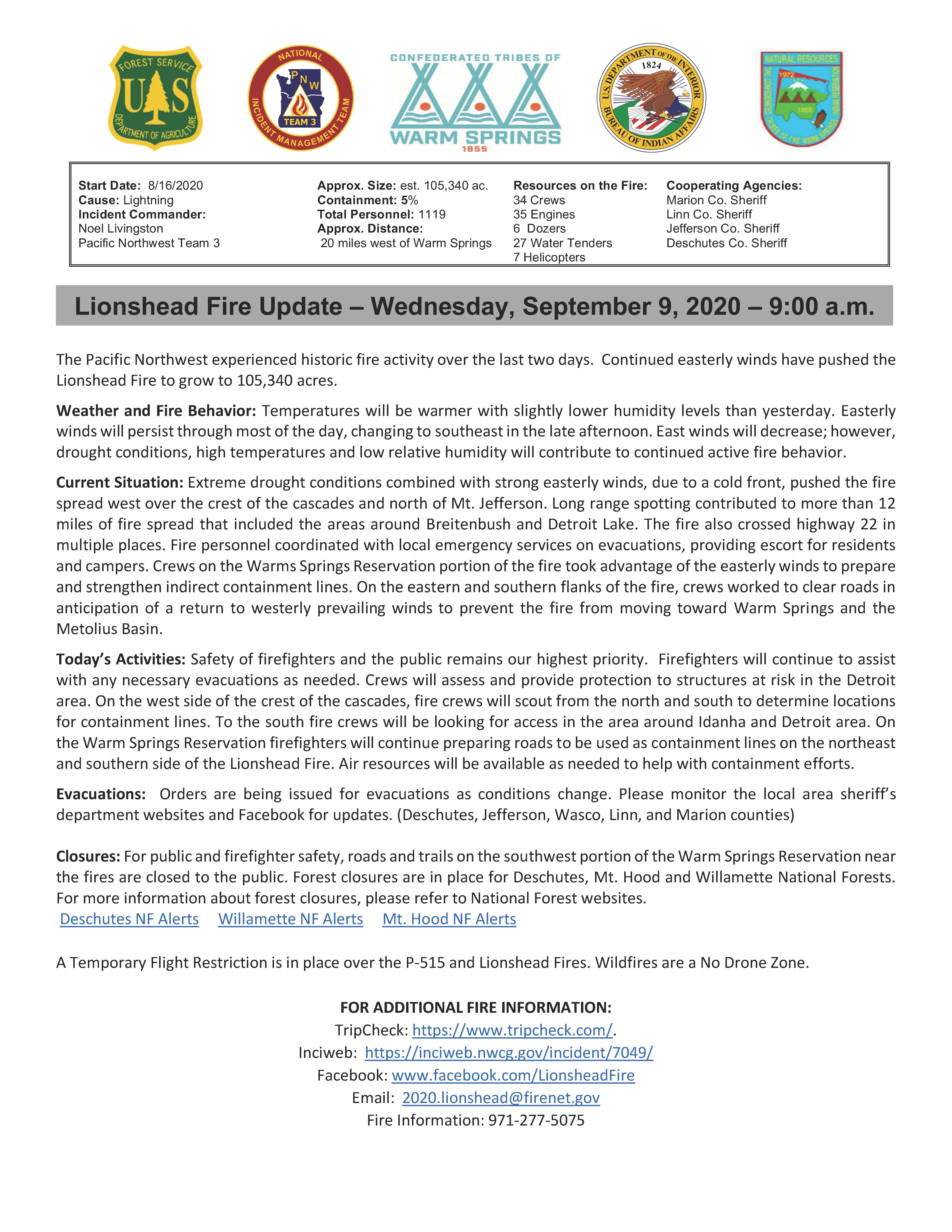
Lionshead Fire Update Wednesday September 9 2020
Related Incident:
Publication Type: News
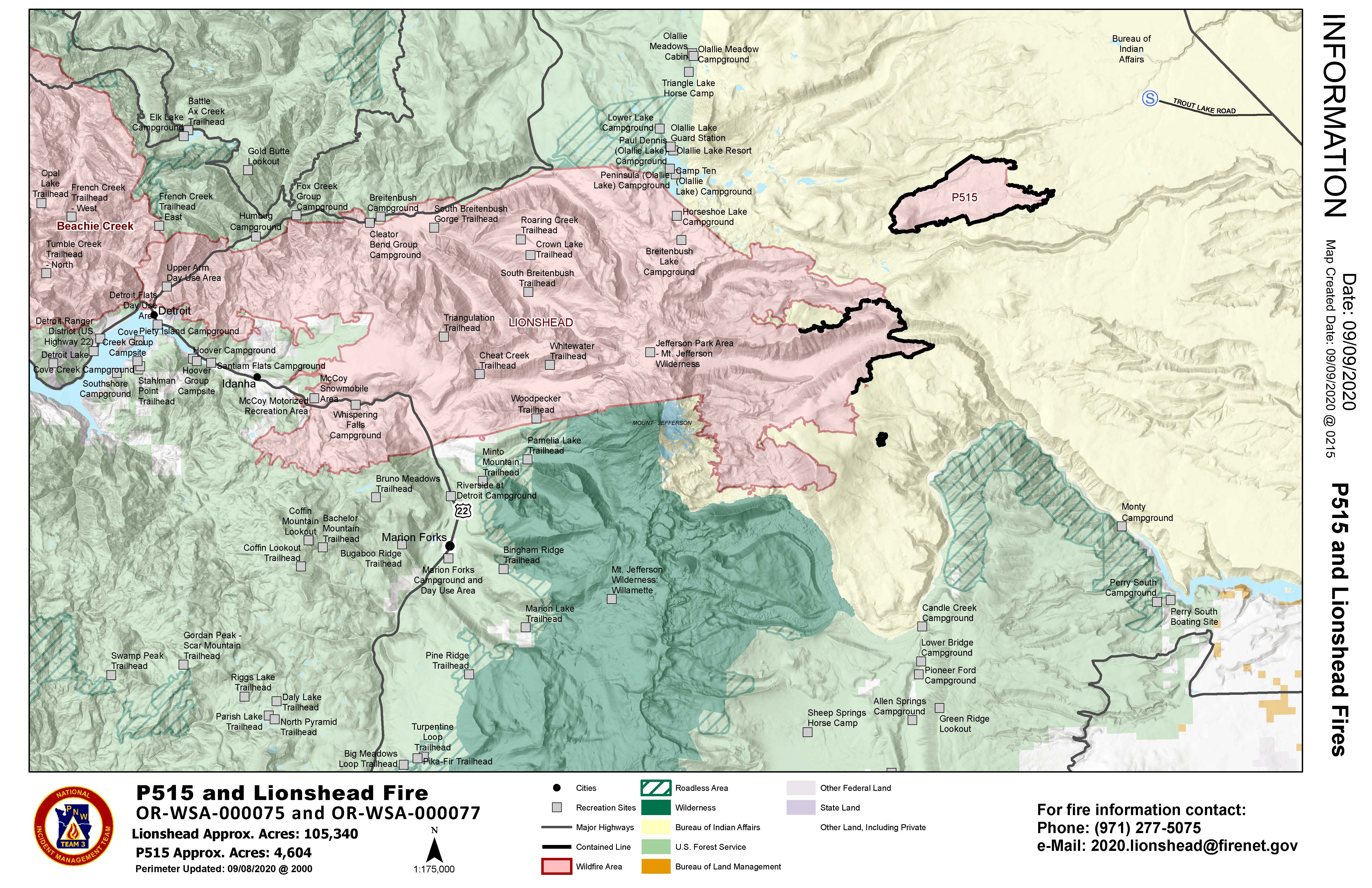
The Pacific Northwest experienced historic fire activity over the last two days. Continued easterly winds have pushed the Lionshead Fire to grow to 105,340 acres.
Weather and Fire Behavior: Temperatures will be warmer with slightly lower humidity levels than yesterday. Easterly winds will persist through most of the day, changing to southeast in the late afternoon. East winds will decrease; however, drought conditions, high temperatures and low relative humidity will contribute to continued active fire behavior.
Current Situation: Extreme drought conditions combined with strong easterly winds, due to a cold front, pushed the fire spread west over the crest of the cascades and north of Mt. Jefferson. Long range spotting contributed to more than 12 miles of fire spread that included the areas around Breitenbush and Detroit Lake. The fire also crossed highway 22 in multiple places. Fire personnel coordinated with local emergency services on evacuations, providing escort for residents and campers. Crews on the Warms Springs Reservation portion of the fire took advantage of the easterly winds to prepare and strengthen indirect containment lines. On the eastern and southern flanks of the fire, crews worked to clear roads in anticipation of a return to westerly prevailing winds to prevent the fire from moving toward Warm Springs and the Metolius Basin.
Today’s Activities: Safety of firefighters and the public remains our highest priority. Firefighters will continue to assist with any necessary evacuations as needed. Crews will assess and provide protection to structures at risk in the Detroit area. On the west side of the crest of the cascades, fire crews will scout from the north and south to determine locations for containment lines. To the south fire crews will be looking for access in the area around Idanha and Detroit area. On the Warm Springs Reservation firefighters will continue preparing roads to be used as containment lines on the northeast and southern side of the Lionshead Fire. Air resources will be available as needed to help with containment efforts.
Evacuations: Orders are being issued for evacuations as conditions change. Please monitor the local area sheriff’s department websites and Facebook for updates. (Deschutes, Jefferson, Wasco, Linn, and Marion counties)
Closures: For public and firefighter safety, roads and trails on the southwest portion of the Warm Springs Reservation near the fires are closed to the public. Forest closures are in place for Deschutes, Mt. Hood and Willamette National Forests. For more information about forest closures, please refer to National Forest websites.
Deschutes NF Alerts Willamette NF Alerts Mt. Hood NF Alerts
A Temporary Flight Restriction is in place over the P-515 and Lionshead Fires. Wildfires are a No Drone Zone.
FOR ADDITIONAL FIRE INFORMATION:
TripCheck: https://www.tripcheck.com/.
Inciweb: https://inciweb.nwcg.gov/incident/7049/
Facebook: www.facebook.com/LionsheadFire
Email: 2020.lionshead@firenet.gov
Fire Information: 971-277-5075
Air Quaility Reports for Wednesday September 9 2020
Related Incident:
Publication Type: News
Air quality reports for today are linked below.
Extreme Fire Behavior Causes Substantial Fire Growth
Related Incident:
Publication Type: Announcement
Today was a challenging day for firefighters on the Lionshead Fire which is now estimated to be 100,000+ acres. High winds that grounded aircraft Tuesday afternoon are expected to continue throughout this evening.
Our next update will be tomorrow (Wednesday) morning. Fire weather has been extreme across the region and residents are urged to sign up for emergency alerts through their local Sheriff’s Office in the event of evacuations.
Willamette National Forest Recreation Opportunities Closed
Related Incident:
Publication Type: Closures
Due to dynamic fire conditions, ALL recreation offerings across the Willamette National Forest are closed including campgrounds, day use areas, trails, boat ramps, and more. Forest Service roads are closed to visitors unless you are vacating the Forest.
Mt Hood National Forest Temporarily Closes Forest for Fire Safety
Related Incident:
Publication Type: Closures
NEWS RELEASE
Release Date: September 8, 2020
Media Contact: Heather Ibsen, (360) 831-5219
Mt. Hood National Forest temporarily closes forest for fire safety
The local area remains under the threat of unprecedented and dangerous fire conditions with a combination of extreme heat, significant wind events, dry conditions, and firefighting resources that are stretched thin across the region and nation. Due to these conditions, the Mt. Hood National Forest is temporarily closing to public access. This includes developed campgrounds, dispersed camping, day use areas, wilderness areas, and all forest roads and trails.
This closure goes into effect at 6:00 pm Pacific Daylight Time on Tuesday, September 8, 2020, and will be re-evaluated daily as conditions change. This is a temporary closure to protect public and firefighter safety and health. People in the process of evacuating the forest are exempt from the order.
Extreme fire weather has caused rapid growth of fires, and new ignitions have strained all resources for the forest and region. Nationally, and within Oregon, firefighting resources are operating at maximum capacity resources severely limited. While the forest has been under fire restrictions, we still see unattended and abandoned campfires across the forest, heightening the risk to firefighters, the public, and wildlife.
“At this time, with extreme fire danger, multiple wildfire growing, and new wildfires igniting and multiple evacuations, it’s simply not safe to visit,” said Forest Supervisor Richard Periman. “Thank you for your patience and cooperation during this time of extreme fire threat.”
It is critical that forest visitors follow this important closure for their own safety and the safety of our firefighters. Residents are encouraged to “follow” their local county sheriff’s department Facebook pages and websites for information about evacuation safety.
More information about fires on the Mt. Hood National forest at:
https://www.fs.usda.gov/main/mthood/fire
The Willamette National Forest also has a forest closure in effect. For information visit:
https://www.fs.usda.gov/news/willamette/news-events
Lionshead Fire is Very Active Stay Alert
Related Incident:
Publication Type: Announcement
The Lionshead Fire and multiple others in the area are experiencing very active fire behavior today. Lionshead is currently moving westerly and pushing toward Breitenbush and Detroit, which are both under Level 3 (Go) evacuation orders. Contact your County Sheriff's Office for the most up to date evacuation orders.
Here are some convenient ways to stay informed:
•Willamette Valley Communications Center (WVCC) primarily covers the cities of Salem and Keizer; however, they also cover areas served by the Marion County Sheriff's Office. To register for alerts, visit: https://www.cityofsalem.net/Pages/get-community-alerts.aspx
•METCOM covers Aumsville, Aurora, Butteville, Detroit, Donald, Drakes Crossing, Gates, Gervais, Hubbard, Idanha, Jefferson, Lyons, Mill City, Mt. Angel, Monitor, Scotts Mills, Silverton, St. Paul, Stayton, Sublimity, Turner, and Woodburn. To register for alerts, visit: https://www.metcom911.com/citizen-alert-.
•Integrated Public Alert and Warning System (IPAWS) is used by federal, state, and local authorities to share critical public alerts and warnings. IPAWS is a robust program that allows messages from several sources including the Emergency Alert System (EAS), Wireless Emergency Alerts (WEA), weather, and more. IPAWS notifications are sent by area and to cell phones within the alert area. You do not need to register to receive IPAWS alerts; however, you must have emergency alerts enabled on your phone to receive IPAWS messages on your mobile device.
•Emergency Alert System (EAS) is a system that's been in place for many years and disseminates information over cable television systems, satellite digital audio radio service, direct broadcast satellite, and wireline video service providers. There is no registration required for this service. If an alert is issued, it will automatically broadcast to television and radio stations.
•FlashAlert is used by many local police and fire agencies, as well as schools and other community/government organizations, to send emergency messages via FlashAlert. You can register to receive news releases and emergency notifications. You choose the agencies you wish to hear from. To register, visit: https://www.flashalert.net/.
•Marion County emergency alerts can be found on the Marion County website on the "Alerts & Emergencies" web page. https://www.co.marion.or.us/PW/EmergencyManagement/Pages/alerts.aspx