
Mt Hood National Forest Temporarily Closes Forest for Fire Safety
Related Incident:
Publication Type: Closures
NEWS RELEASE
Release Date: September 8, 2020
Media Contact: Heather Ibsen, (360) 831-5219
Mt. Hood National Forest temporarily closes forest for fire safety
The local area remains under the threat of unprecedented and dangerous fire conditions with a combination of extreme heat, significant wind events, dry conditions, and firefighting resources that are stretched thin across the region and nation. Due to these conditions, the Mt. Hood National Forest is temporarily closing to public access. This includes developed campgrounds, dispersed camping, day use areas, wilderness areas, and all forest roads and trails.
This closure goes into effect at 6:00 pm Pacific Daylight Time on Tuesday, September 8, 2020, and will be re-evaluated daily as conditions change. This is a temporary closure to protect public and firefighter safety and health. People in the process of evacuating the forest are exempt from the order.
Extreme fire weather has caused rapid growth of fires, and new ignitions have strained all resources for the forest and region. Nationally, and within Oregon, firefighting resources are operating at maximum capacity resources severely limited. While the forest has been under fire restrictions, we still see unattended and abandoned campfires across the forest, heightening the risk to firefighters, the public, and wildlife.
“At this time, with extreme fire danger, multiple wildfire growing, and new wildfires igniting and multiple evacuations, it’s simply not safe to visit,” said Forest Supervisor Richard Periman. “Thank you for your patience and cooperation during this time of extreme fire threat.”
It is critical that forest visitors follow this important closure for their own safety and the safety of our firefighters. Residents are encouraged to “follow” their local county sheriff’s department Facebook pages and websites for information about evacuation safety.
More information about fires on the Mt. Hood National forest at:
https://www.fs.usda.gov/main/mthood/fire
The Willamette National Forest also has a forest closure in effect. For information visit:
https://www.fs.usda.gov/news/willamette/news-events
Lionshead Fire is Very Active Stay Alert
Related Incident:
Publication Type: Announcement
The Lionshead Fire and multiple others in the area are experiencing very active fire behavior today. Lionshead is currently moving westerly and pushing toward Breitenbush and Detroit, which are both under Level 3 (Go) evacuation orders. Contact your County Sheriff's Office for the most up to date evacuation orders.
Here are some convenient ways to stay informed:
•Willamette Valley Communications Center (WVCC) primarily covers the cities of Salem and Keizer; however, they also cover areas served by the Marion County Sheriff's Office. To register for alerts, visit: https://www.cityofsalem.net/Pages/get-community-alerts.aspx
•METCOM covers Aumsville, Aurora, Butteville, Detroit, Donald, Drakes Crossing, Gates, Gervais, Hubbard, Idanha, Jefferson, Lyons, Mill City, Mt. Angel, Monitor, Scotts Mills, Silverton, St. Paul, Stayton, Sublimity, Turner, and Woodburn. To register for alerts, visit: https://www.metcom911.com/citizen-alert-.
•Integrated Public Alert and Warning System (IPAWS) is used by federal, state, and local authorities to share critical public alerts and warnings. IPAWS is a robust program that allows messages from several sources including the Emergency Alert System (EAS), Wireless Emergency Alerts (WEA), weather, and more. IPAWS notifications are sent by area and to cell phones within the alert area. You do not need to register to receive IPAWS alerts; however, you must have emergency alerts enabled on your phone to receive IPAWS messages on your mobile device.
•Emergency Alert System (EAS) is a system that's been in place for many years and disseminates information over cable television systems, satellite digital audio radio service, direct broadcast satellite, and wireline video service providers. There is no registration required for this service. If an alert is issued, it will automatically broadcast to television and radio stations.
•FlashAlert is used by many local police and fire agencies, as well as schools and other community/government organizations, to send emergency messages via FlashAlert. You can register to receive news releases and emergency notifications. You choose the agencies you wish to hear from. To register, visit: https://www.flashalert.net/.
•Marion County emergency alerts can be found on the Marion County website on the "Alerts & Emergencies" web page. https://www.co.marion.or.us/PW/EmergencyManagement/Pages/alerts.aspx
Willamette National Forest Closures update Sep 7 2020
Related Incident:
Publication Type: Closures
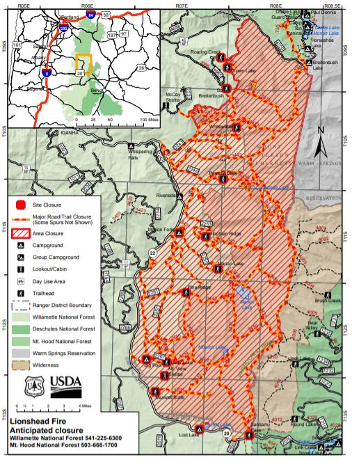
Lionshead Fire to temporarily close Mt. Jefferson Wilderness and adjacent national forest lands
Springfield, OR, Sept. 6, 2020 – Fire managers warn that the Lionshead Fire is exhibiting active behavior on the Warm Springs Reservation and Deschutes National Forest that could soon spread onto the Willamette National Forest. To uphold public safety as the highest priority, the Willamette National Forest is preparing an expanded closure order in the Mt. Jefferson Wilderness west to Oregon State Highway 22 and south to Oregon State Highway 20.
“We are ramping up our closure to ensure folks stay clear of the area during the next 72- hours,” said Willamette Forest Supervisor David Warnack. “We plan to shrink the closure as appropriate once we see how the fire behaves with anticipated high wind gusts during these next few days.” For public safety, Detroit Wilderness Rangers alongside Linn and Marion Sheriff Officers, are working together to notify visitors in the area encompassed by the expanded closure order.
Over these next few days, the combination of high winds at 15-30 mph from the east with gusts up to 50 mph, low humidity, and dry fuels could cause rapid fire spread. A red flag warning is in effect for wind and low humidity through Wednesday evening. Please observe public use restrictions and help us limit potential new starts during this time. “The fire weather forecasted is extremely rare and occurs only a few times a century,” said Eric Johnson, Deputy Fire Staff for Northwest Oregon Fire Management. “Any new fires will prove challenging to suppress, so please help firefighters by not doing activities that could create sparks,” said Johnson.
Willamette National Forest Closures due to Lionshead Fire Sep 6 2020
Related Incident:
Publication Type: Announcement
Please see attachments below:
Deschutes National Forest closures due to Lionshead Fire Sep 6 2020
Related Incident:
Publication Type: Announcement
Please see attachments below:
P515 Fire and Lionshead Fire Closures
Related Incident:
Publication Type: Closures
Closures in effect are: Trout Lake Road at pavement end; Road B140 at Potter’s Pond; Road B210 and Road P-500.All trails south of Trout Lake, west of M-120 Metolious Bench, east of Mt. Jefferson, and north of J-195 will be closed to the public. Also, Tenino Road (P-200) will be closed to the public, only fire personnel and residents are allowed on Tenino Road (P-200).
Castle Fire closures remain in effect for severely burned areas
Related Incident:
Publication Type: Closures
From August to December 2020, the Castle Fire burned across thousands of acres in the Sequoia National Forest and Giant Sequoia National Monument. Forest officials evaluated the most impacted area to refine the existing forest closure. As a result, areas outside the burned perimeter will reopen on February 16, 2021. Details and a map of the new forest closure order can be found under Related Information below or the Sequoia National Forest website.
Lands managed by the Sequoia National Forest between Camp Nelson and the community of Ponderosa will remain closed. All travelers along Highway 190 or Redwood Drive thru the fire area should use extreme caution when driving. As winter weather continues, conditions may worsen, making roads impassable. Be aware of potential safety hazards such as fire weakened trees, falling rocks, mud, and debris washed down from steep banks.
In the spring, some developed campgrounds and recreation sites will reopen first, while dispersed camping and foot traffic will not be permitted in the fire area. Most recreation opportunities below Camp Nelson will be open. Recreation opportunities along the Western Divide Highway, including the Trail of 100 Giants, will open when weather permits.
The North Road (FS21S50) and the Lloyd Meadow Road (FS22S82) north of Dry Meadow Road (FS22S53) will remain closed, possibly through summer. Access for trails into the Golden Trout Wilderness will be limited to the Blackrock Trailhead or trailheads in neighboring Sequoia National Park and Inyo National Forest. Wilderness permits for travel from Blackrock Trailhead can be obtained on the Sequoia National Forest website https://www.fs.usda.gov/detail/sequoia/passes-permits/recreation.
Fire and resource specialists continue their efforts toward fire suppression repair, burned area emergency response (BAER) and long-term recovery and restoration of the area. Work to remove hazard trees along roads and trails, recreation sites, and around communities will start again as soon as weather permits. A more detailed landscape restoration project is in the planning stage but will take years to complete on the ground.
“I am pleased to announce that we have been able to reopen some areas to the public. Please help us by respecting the closures that are still in effect; these are in place for public safety,” stated District Ranger Eric LaPrice. “Offering recreational opportunities to the public is important to us. Forest officials must balance reopening areas too soon that are naturally recovering from fire, especially sequoia groves. To prevent trampling of new growth and compaction of soil, we ask the public to stay on roads and trails in the burned areas as they become available.”
Castle Fire area closure continues through February 15 2021
Related Incident:
Publication Type: Closures
Forest officials have extended the closure of Sequoia National Forest managed land near the Castle Fire through February 15, 2021. Hazardous conditions exist for anyone walking through the burned area such as fire weakened trees and potential debris flows. The area is being evaluated for what portions can be reopened before summer.
SQF Complex reaches containment fire area remains closed
Related Incident:
Publication Type: News
SPRINGVILLE, January 6, 2021 – Containment of the SQF Complex reached 100% for the portion of the fire managed by the Sequoia National Forest. Winter conditions are expected to extinguish remaining hot spots. Until the area receives substantial precipitation, those traveling thru the fire area can expect to see pockets of smoke deep inside the fire perimeter.
Smoldering debris around tree trunks continue to weaken fire-damaged trees, posing a hazard of them falling at any time. Smoldering stump holes and their roots can be found burning months after a wildfire, posing a hazard for anyone stepping near or on them. Local firefighters will continue to patrol and monitor the fire's edge, extinguishing hot spots that could spread beyond contained lines. Much work is left to be done on fire suppression repair; heavy equipment is anticipated to return in the spring to continue this effort.
Forest officials have extended the closure of Sequoia National Forest managed land affected by the Castle Fire through January 31, 2021. Details of the Forest Closure and a map of the closed area can be found on Inciweb https://inciweb.nwcg.gov/incident/article/7048/58930/
"Once the area receives enough precipitation to fully extinguish remaining hot spots, including duff burning around tree trunks and deep inside stump holes and roots, the Forest Service hopes to re-open the area to the public,” stated District Ranger Eric LaPrice. “We are all hoping for more rain and snow to assist us in this effort. In the meantime, thank you for your patience while we keep the area closed to protect the public.”
An Interagency Emergency Task Force continues to prepare for flash floods and debris flow, busily cleaning debris from culverts and drains to minimize impacts. Those traveling thru the fire area on Highway 190 should expect frequent delays at roadblocks where work is ongoing. Information and resources available to residents affected by the SQF Complex Fire can be found on Tulare Counties website https://tularecounty.ca.gov/recovers/
Castle Fire area closure continues through January 31 2021
Related Incident:
Publication Type: Closures
Forest officials have extended the closure of Sequoia National Forest managed land near the Castle Fire through January 31, 2021. Despite cooler temperatures and some precipitation, hot spots continue to smolder and burn through dry vegetation. This creates hazardous conditions for anyone walking through the burned area such as smoldering stump holes and fire weakened trees.