
EVACUATION INFORMATION UPDATELassen County Sheriff 82820
Related Incident:
Publication Type: Announcement
UPDATED PRESS RELEASE 8/28/2020 9:30AM
SHEEP (NORTH COMPLEX) FIRE EVACUATION WARNING LIFTED FOR SOME AREAS
Effective Friday, August 28th at 10am, the following Evacuation Warnings are lifted:
• Highway 36 from Harris Drive west to Devil’s Corral and all road accessed by Highway 36.
• County Road A-1 to Lake Forest Estates and all roads accessed by A-1 to that point.
The following are instructions for residents returning home:
1. Residents should be aware that changing conditions in fire activity may cause this area to escalate back to a mandatory evacuation order at any time.
If you have evacuated large animals and vehicles, please keep them out of the area.
2. Please use caution, reduce your speed, drive with your headlights on and yield to emergency personnel.
3. Just because the flames are out doesn’t mean the danger is over. Damaged trees, structural damage, and flash flooding are just some of the dangers that exist after a wildfire. DO NOT put yourself or your loved ones in danger by exploring. Expect to see hotspots for some time. Do not call 911 to report unless there is an immediate threat to life or property.
The following Mandatory Evacuation Orders are in effect for the following areas:
• Baxter Creek Road.
• Wingfield Road at Baxter Creek Road to where the pavement begins at Peter Lassen’s Grave.
• Cheney Creek Road and all roads accessed by Cheney Creek Road.
The following Evacuation Warnings are in effect for the following areas:
• Gem Drive, Pearl Circle, and all roads accessed by those roads.
• Richmond Road and all roads accessed by Richmond Road from Hwy 395 to Pearl Circle. but NOT Cheney Creek Road, Baxter Creek Road, or the closed portion of Wingfield Road which are still under Mandatory Evacuation Order.
• Wingfield Road from Richmond Road to Peter Lassen’s Grave.
• Sunnyside Road from Hwy 395 to County Road A-3.
• Everything West of Highway 395 from Richmond Road East at the intersection by Susanville Ford to Janesville Grade and all roads in between.
• Main Street Janesville from Highway 395 to Janesville Grade and all roads accessed by Main Street Janesville.
• Bass Hill Road.
• Wingfield Road East from Bass Hill Road to Wingfield Road East including Elysian Valley Road, Indians Road and all connecting roads but NOT Baxter Creek Road.Road Closures:
• Cheney Creek Road.
• Wingfield Road at Baxter Creek Road to where the pavement begins at Peter Lassen’s Grave.
• Elysian Valley Road.
• Forest Service Road 29N03 by Roxie Peconom Campground.
For questions about whether your address is under mandatory, warning, or lifted status, please call (530)316-4487. Dispatch has been flooded with calls that can better be answered by someone who isn't also trying to answer emergency calls. People under order need to leave immediately. People under warning need to prepare to leave soon. Please use caution, drive with your headlights on and yield to emergency personnel. Residents needing assistance evacuating are asked to call the dispatch center at (530)257-6121. If you need shelter, go to the Lassen Community College Dormitories. Large animals can be housed at the Lassen County Fairgrounds. Go to the Fair office on Russell Drive first before 5pm. After 5pm, call the Emergency Shelter Line at (530)250-9088. Liability, feed, and care of large animals is the sole responsibility of the animal’s owner. Deputies will be going door to door to make notification.
EVACUATION INFORMATION UPDATEPlumas County Sheriff 82820
Related Incident:
Publication Type: Announcement
EVACUATION AND ROAD CLOSURE INFORMATION
MANDATORY EVACUATION ORDERS remain in effect for the following areas:
QUINCY LAPORTE ROAD from Thompson Creek south to Red Bridge (Middle Fork of the Feather River.
Highway 70: From Massack Rest Area to Spring Garden
COMMUNITY OF SPRING GARDEN
COMMUNITY OF GREENHORN RANCH
EVACUATION ADVISORIES ARE IN EFFECT for the following areas:
COMMUNITY OF SLOAT
COMMUNITY OF CROMBERG
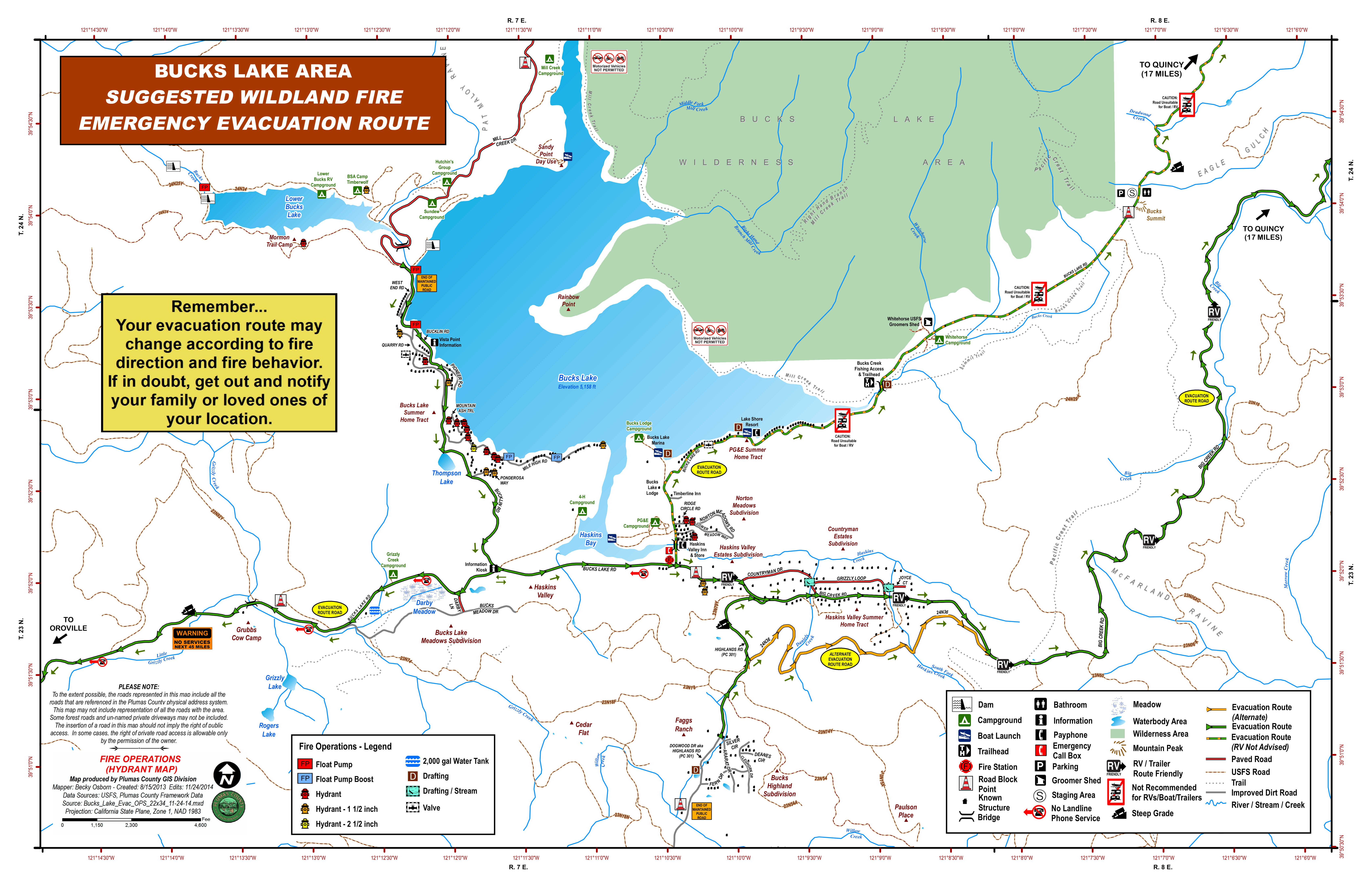
Bucks Lake: Big Creek Road from the Mount Ararat Road to Bucklin Road (to include Countryman
Drive and Grizzly Loop) and Bucks Lake Road south of the Old Transfer Station Rd (Timberline Lodge)
extending to the area of the On Top Mine to include the Bucks Highlands area.
Quincy LaPorte Road from Highway 70 south to Thompson Creek.
MODIFIED: Quincy LaPorte Road from Quincy LaPorte Road & Highway 70 to Massack.
o Highway 70 at Chandler Road, east to the west side of the Massack Rest Area.
ROAD CLOSURES AND INFORMATION
Quincy LaPorte Road from Hwy 70 to Thompson Creek is open to RESIDENTS ONLY
Quincy LaPorte Road from Thompson Creek to Red Bridge is CLOSED
Peppard Flat Road (The dirt portion) is CLOSED
NOTABLE CHANGES The below areas are being REMOVED from ADVISORY STATUS
NEW EAST QUINCY, south of Lee Road from Radio Hill Road east.
o To include EAST QUINCY, south of Highway 70 between Millcreek (to include Mill CreekRoad and Forest View Drive) extending east to Quincy LaPorte Road.
NEW Chandler Road (east end), from Highway 70 east to Carol Lane East. SHELTER INFORMATION
None at this time; however, if you need assistance contact Plumas Co. Social Services at 283-6350
If you need assistance with animals contact Plumas County Animal Services at 283-3673. Large animals/livestock can also be accommodated.
THE ABOVE INFORMATION IS SUBJECT TO CHANGE AT ANY TIME
Smoke Outlook 82820
Related Incident:
Publication Type: News
See related file for today's SMOKE OUTLOOK
Bear Fire AM UPDATE 82820
Related Incident:
Publication Type: News
Acres: 27,962 combined (Claremont 22,244; Bear 6,578) Contained: Claremont 46%; Bear 0%
Resources: 15 dozers, 80 engines, 11 hand crews, 7 helicopters, 10 water tenders, 6 other heavy equipment and 642 total personnel. These resources are shared with the North Complex.
Community boards: Fire staff are posting information daily throughout the community. Find out where: https://arcg.is/18vnSe.
Current Situation on the Bear: As other fires in the North Complex increase in containment, focus on the Bear Fire will ramp up and additional resources are being assigned to that fire. Priority has shifted to completing firelines to keep the fire out of the Willow Creek drainage and protect the Haskins Valley and Bucks Lake areas. Dozer lines have been completed across the north of the fire to prevent any push toward Meadow Valley, Quincy and Tollgate.
Current Situation on the Claremont: Crews are nearing completion on dozer line along the western edge of the Claremont Fire and have hose lays in place near Claremont Trail, but the priority sections remain to the east. Crews implemented strategic firing operations above Estray Creek to help close the gap between the fire and Highway 70. Yesterday’s wind shift tested lines near Nelson Lookout and 23N10 roads and caused spot fires that firefighters were able to pick up and get lines around. Securing these areas today remains a top priority.
Evacuations: Mandatory Evacuations are in place for the following locations according to the Plumas County Sheriff’s Office: Quincy Laporte Road from Thompson Creek south to Red Bridge (Middle fork of the Feather River.); Highway 70: From Massack to Spring Garden; Spring Garden Community; Greenhorn Ranch Community.
Evacuation Advisories are in effect for the following: Bucks Lake Big Creek Road from the Mount Ararat Road to Bucklin Road (to include Countryman Drive and Grizzly Loop) and Bucks Lake Road south of the Old Transfer Station Rd (Timberline Lodge) extending to the area of the On Top Mine to include the Bucks Highlands area; Quincy Laporte Road from Highway 70 south to Thompson Creek; Quincy Laporte Road from Highway to Massack; East Quincy, south of Lee Road from Radio Hill Road east. (to include East Quincy, south of Highway 70 between Mill Creek (to include mill Creek Road and Forest View Drive) extending east to Quincy Laporte Road; Chandler Road (east end) from Highway 70 east to Carol Lane East; Sloat Community; Cromberg Community.
Plumas County launched a Claremont Fire Evacuation Information website as an online resource to view the fire map, current evacuation zones, sign up for Code Red, follow links to USFS fire incidents pages, and find the Sheriff’s Office Facebook page. http://mgo.ms/s/yokm6
The evacuation shelter in Quincy has been closed.
Road Closure: Highway 70 currently is open in both directions with a police escort from Quincy La Porte Road to Spring Garden. Quincy La Porte Road from Highway 70 to Thompson Creek Road is open to residents only. Quincy La Porte Road from Highway 70 to Red Bridge and Peppard Flat Road (dirt portion) remain closed. The Pacific Crest Trail from Onion Valley to Bucks Summit remains closed as does Thompson Creek Road (Forest Road 24N26) and Red Bridge Campground. For further information on closures go to: https://www.fs.usda.gov/alerts/plumas/alerts-notices.
For immediate text notifications sign up for the Plumas County’s CodeRed Emergency Alert System on their website at https://www.plumascounty.us/2163/. Visit CalTrans at quickmap.dot.ca.gov or call 1-800-427-7623 for the latest maps and information of road closures in your area.
Weather: Generally east winds move in to the area today and will provide relief from the smoke for portions of the communities effected by the North Complex. There is a possibility of thunderstorms throughout the fire areas but the chance is minimal. As the temperature increases and humidity decreases throughout the day, fire behavior and smoke production will increase into the afternoon.
Air Quality: East winds are expected through the afternoon continuing to move smoke to the west and south. Smoke from the North Complex that settled over the area last night is forecast to dissipate this afternoon but might return to the region again this evening. Impacts are again seen closet to the fire. Quincy and Susanville continue to be hardest hit. The Reno/Tahoe area can continue to expect decreased levels of air quality as smoke lingers in the area.
COVID-19: California Interagency Incident Management Team 1 has implemented precautionary measures to prevent the spread of COVID-19 in both fire camp and the surrounding communities.
Bear Fire PM UPDATE 8272020
Related Incident:
Publication Type: News
AUGUST 27, 2020 8 pm
Claremont and Bear – Evening Update
Acres: 26,013 combined (Claremont 20,697; Bear 5,176) Contained: Claremont 47%; Bear 0%
Resources: 15 dozers, 80 engines, 11 hand crews, 7 helicopters, 10 water tenders, 6 other heavy equipment and 642 total personnel. These resources are shared with the North Complex.
Community boards: Fire staff are posting information daily throughout the community. Find out where: https://arcg.is/18vnSe.
Current Situation on the Claremont: Diligent work by firefighters produced greater containment on the Claremont Fire today and it sits at 47% and 20,697 acres. Crews faced a wind shift from previous days and the westerly flow posed containment issues on the far southeast corner of the fire where personnel picked up several spot fires in the area of Harrison Flat. Other sections of the fire, including north of Highway 70, remained in place and were in good condition as crews monitored, mopped up lingering heat sources and patrolled for any hot spots to protect the communities of Spring Garden and Greenhorn.
Current Situation on the Bear: Good progress was made across the northern section of the Bear Fire where crews neared completion on a dozer line running east to west utilizing forest roads to prevent the fire from progressing toward Quincy. Crews also are working to build indirect line to the west. The fire is actively burning in an area with little to no fire history – north of the Middle Fork of the Feather River, a mile northwest of Butte Bar Campground and 1.5 miles southeast of Lookout Rock.
Evacuations: Mandatory Evacuations are in place for the following locations according to the Plumas County Sheriff’s Office: Quincy Laporte Road from Thompson Creek south to Red Bridge (Middle fork of the Feather River.); Highway 70: From Massack to Spring Garden; Spring Garden Community; Greenhorn Ranch Community.
Evacuation Advisories are in effect for the following: Bucks Lake Big Creek Road from the Mount Ararat Road to Bucklin Road (to include Countryman Drive and Grizzly Loop) and Bucks Lake Road south of the Old Transfer Station Rd (Timberline Lodge) extending to the area of the On Top Mine to include the Bucks Highlands area; Quincy Laporte Road from Highway 70 south to Thompson Creek; Quincy Laporte Road from Highway to Massack; East Quincy, south of Lee Road from Radio Hill Road east. (to include East Quincy, south of Highway 70 between Mill Creek (to include mill Creek Road and Forest View Drive) extending east to Quincy Laporte Road; Chandler Road (east end) from Highway 70 east to Carol Lane East; Sloat Community; Cromberg Community.
Plumas County launched a Claremont Fire Evacuation Information website as an online resource to view the fire map, current evacuation zones, sign up for Code Red, follow links to USFS fire incidents pages, and find the Sheriff’s Office Facebook page. http://mgo.ms/s/yokm6
The evacuation shelter in Quincy has been closed.
Road Closure: Highway 70 currently is open in both directions with a police escort from Quincy La Porte Road to Spring Garden. Quincy La Porte Road from Highway 70 to Thompson Creek Road is open to residents only. Quincy La Porte Road from Highway 70 to Red Bridge and Peppard Flat Road (dirt portion) remain closed. The Pacific Crest Trail from Onion Valley to Bucks Summit remains closed as does Thompson Creek Road (Forest Road 24N26) and Red Bridge Campground. For further information on closures go to: https://www.fs.usda.gov/alerts/plumas/alerts-notices.
For immediate text notifications sign up for the Plumas County’s CodeRed Emergency Alert System on their website at https://www.plumascounty.us/2163/.
Visit CalTrans at quickmap.dot.ca.gov or call 1-800-427-7623 for the latest maps and information of road closures in your area.
Weather: Hotter and drier conditions and a wind shift brought increased fire activity over much of the fire area. Tomorrow, there is a chance for scattered thunderstorms, increased winds, and erratic fire behavior.
Air Quality: Quincy and Susanville can expect continued higher levels of smoke while other areas near the North Complex should see moderate and “unhealthy for sensitive groups” levels of smoke. Widespread haze continues to linger but improved mixing heights should help dissipate some of the smoke.
COVID-19: California Interagency Incident Management Team 1 has implemented precautionary measures to prevent the spread of COVID-19 in both fire camp and the surrounding communities.
Smoke Outlook 8272020
Related Incident:
Publication Type: News
See related file for today's SMOKE OUTLOOK
EVACUATION INFORMATION UPDATE Plumas County Sheriff 8272020 10 am
Related Incident:
Publication Type: Announcement
EVACUATION AND ROAD CLOSURE INFORMATION
MANDATORY EVACUATION ORDERS have been issued for the following areas:
• QUINCY LAPORTE ROAD from Thompson Creek south to Red Bridge (Middle Fork of the Feather River.
• Highway 70: From Massack Rest Area to Spring Garden
• COMMUNITY OF SPRING GARDEN
• COMMUNITY OF GREENHORN RANCH
EVACUATION ADVISORIES ARE IN EFFECT for the following areas:
• EAST QUINCY, south of Lee Road from Radio Hill Road east.
o To include EAST QUINCY, south of Highway 70 between Millcreek (to include Mill Creek Road and Forest View Drive) extending east to Quincy LaPorte Road.
• Chandler Road (east e11)d, from Highway 70 east to Carol Lane East.
• COMMUNITY OF SLOAT
• COMMUNITY OF CROMBERG
• Bucks Lake: Big Creek Road from the Mount Ararat Road to Bucklin Road (to include Countryman Drive and Grizzly Loop) and Bucks Lake Road south of the Old Transfer Station Rd (Timberline Lodge) extending to the area of the On Top Mine to include the BucksHighlands area.
• Quincy LaPorte Road from Highway 70 south to Thompson Creek.
• Quincy LaPorte Road from Quincy LaPorte Road & Highway 70 to Massack.
ROAD CLOSURES AND INFORMATION
• NEW Quincy LaPorte Road fro1n Hwy 70 to Tho1npson Creek is open to RESIDENTS ONLY
• Quincy LaPorte Road fro1n Tho1npson Creek to Red Bridge is CLOSED
• Peppard Flat Road (The dirt portion) is CLOSED
SHELTER INFORMATION
None at this time; however, we are prepared to open one at any time.
If you need assistance with animals, contact Plumas County Animal Services at 283-3673. Large animals/livestock can also be accommodated.
THE ABOVE INFORMATION IS SUBJECT TO CHANGE AT ANY TIME
Bear Fire AM UPDATE 8272020
Related Incident:
Publication Type: News
AUGUST 27, 2020 8 am
Claremont and Bear – Morning Update
Acres: 26,013 combined (Claremont 20,697; Bear 5,176) Contained: Claremont 30%; Bear 0%
Resources: 11 dozers, 74 engines, 7 hand crews, 7 helicopters, 9 water tenders, and 551 total personnel. These resources are shared with the North Complex.
Current Situation on the Claremont: Firefighters made significant progress yet again and containment on the Claremont Fire is up to 30% as crews work to pinch the fire off and steer it into manageable terrain. With protection of local communities one of the top priorities, personnel are working to button up the eastern section of the fire as winds shift today and become more westerly and humidity drops today.
Current Situation on the Bear: The Bear fire remains active. Firefighters are working to build line north of the fire to prevent any push toward Quincy. The fire is actively burning in an area with little to no fire history – north of the Middle Fork of the Feather River, 1 mile northwest of Butte Bar Campground and 1.5 miles southeast of Lookout Rock.
Evacuations: Mandatory Evacuations are in place for the following locations according to the Plumas County Sheriff’s Office: Quincy Laporte Road from Thompson Creek south to Red Bridge (Middle fork of the Feather River.); Highway 70: From Massack to Spring Garden; Spring Garden Community; Greenhorn Ranch Community.
Evacuation Advisories are in effect for the following: Bucks Lake Big Creek Road from the Mount Ararat Road to Bucklin Road (to include Countryman Drive and Grizzly Loop) and Bucks Lake Road south of the Old Transfer Station Rd (Timberline Lodge) extending to the area of the On Top Mine to include the Bucks Highlands area; Quincy Laporte Road from Highway 70 south to Thompson Creek; Quincy Laporte Road from Highway to Massack; East Quincy, south of Lee Road from Radio Hill Road east. (to include East Quincy, south of Highway 70 between Mill Creek (to include mill Creek Road and Forest View Drive) extending east to Quincy Laporte Road; Chandler Road (east end) from Highway 70 east to Carol Lane East; Sloat Community; Cromberg Community.
Plumas County launched a Claremont Fire Evacuation Information website as an online resource to view the fire map, current evacuation zones, sign up for Code Red, follow links to USFS fire incidents pages, and find the Sheriff’s Office Facebook page. http://mgo.ms/s/yokm6
The evacuation shelter in Quincy has been closed.
Road Closure: Highway 70 currently is open in both directions with a police escort from Quincy La Porte Road to Spring Garden. Quincy La Porte Road from Highway 70 to Red Bridge and Peppard Flat Road (dirt portion) remain closed. The Pacific Crest Trail from Onion Valley to Bucks Summit remains closed as does Thompson Creek Road (Forest Road 24N26) and Red Bridge Campground. For further information on closures go to: https://www.fs.usda.gov/alerts/plumas/alerts-notices.
For immediate text notifications sign up for the Plumas County’s CodeRed Emergency Alert System on their website at https://www.plumascounty.us/2163/. Visit CalTrans at quickmap.dot.ca.gov or call 1-800-427-7623 for the latest maps and information of road closures in your area.
Weather: Today brings a change in the weather pattern as hotter, drier conditions move in. With lower humidity and increased heat comes the potential for increased fire activity and the likelihood residents and visitors will see larger smoke columns than in recent days. While humidities will dip into the 15-25% range, winds will remain relatively calm and be west in the morning, shifting to northwest later in the day.
Air Quality: Quincy and Susanville can expect continued higher levels of smoke while other areas near the North Complex should see moderate and “unhealthy for sensitive groups” levels of smoke. Widespread haze continues to linger but improved mixing heights should help dissipate some of the smoke. Terrain driven winds are expected to turn westerly in the afternoon and west-northwest in the evening. Smoke is expected to spread around quite a bit.
COVID-19: California Interagency Incident Management Team 1 has implemented precautionary measures to prevent the spread of COVID-19 in both fire camp and the surrounding communities.
Bear Fire PM UPDATE 8262020
Related Incident:
Publication Type: News
AUGUST 26, 2020 8 pm
Claremont and Bear – Evening Update
Acres: 25,324 combined (Claremont 20,423; Bear 4,901) Contained: Claremont 7%; Bear 0%
Resources: 11 dozers, 74 engines, 7 handcrews, 7 helicopters, 9 water tenders, and 551 total personnel. These resources are shared with the North Complex.
Current Situation on the Claremont: Residents in the La Porte Road area were allowed to return to their homes as the evacuation order for that section reduced from mandatory to an advisory as crews continued to gain ground in terms of building containment line. Highway 70 is open to traffic in both directions with law enforcement escort. Fire activity increased during the afternoon hours with the primary growth in the southwest corner of the fire south of Highway 70 and west of Spring Garden. Firefighters will continue to patrol and mop up and reinforce firelines where applicable overnight.
Current Situation on the Bear: Crews continued to build a defensive line along Slate Creek Spur on the north side of the fire in an effort to catch any threat of it moving north toward Quincy as well as build indirect line on the west side of the fire. The fire remains active and is backing through significant fuels in an area that has little to no fire history. The fire currently is north of the Middle Fork of the Feather River 1 mile northwest of Butte Bar Campground and 1.5 miles southeast of Lookout Rock.
Evacuations: Evacuation Advisory Alerts remain in effect for the communities of Cromberg and Sloat. Residents there should make preparations to evacuate. The mandatory evacuation order was MODIFIED to ADVISORY STATUS Tuesday for East Quincy, south of Highway 70 between Mill Creek (to include Mill Creek Road and Forest View Drive) extending east to Quincy La Porte Road. All other evacuation orders and advisories remain in effect.
Plumas County launched a Claremont Fire Evacuation Information website as an online resource to view the fire map, current evacuation zones, sign up for Code Red, follow links to USFS fire incidents pages, and find the Sheriff’s Office Facebook page. http://mgo.ms/s/yokm6
The evacuation shelter in Quincy has been closed.
Road Closure: Highway 70 is currently open in both directions with a police escort from Quincy La Porte Road to Spring Garden. Quincy La Porte Road from Highway 70 to Red Bridge and Peppard Flat Road (dirt portion) remain closed. The Pacific Crest Trail from Onion Valley to Bucks Summit remains closed. For further information on closures go to: https://www.fs.usda.gov/alerts/plumas/alerts-notices.
For immediate text notifications sign up for the Plumas County’s CodeRed Emergency Alert System on their website at https://www.plumascounty.us/2163/. Visit CalTrans at quickmap.dot.ca.gov or call 1-800-427-7623 for the latest maps and information of road closures in your area.
Weather: Overnight, winds will be generally west-southwest at 5-10mph in the lower elevations and southwest at 5-10 gusting to 15 on the upper slopes. Hotter, drier weather is forecast to start Thursday and continuing through the weekend with temperatures increasing by roughly 10 degrees throughout the area. Southeast air flow Friday will bring a slight chance of slow-moving thunderstorms. Otherwise, hot and dry will be the theme this weekend into early next week.
Air Quality: Quincy and Susanville continue to be impacted by Unhealthy to Hazardous levels of smoke. Southwest winds should keep smoke moving to the northeast of the fires. For more information on air quality and to see monitors near you, visit Airnow or the California Smoke Blog. For more information on what you can do to protect yourself and loved ones, visit the EPA's site on fires and your health. Your local health department is also a good source of information.
COVID-19: California Interagency Incident Management Team 1 has implemented precautionary measures to prevent the spread of COVID-19 in both fire camp and the surrounding communities.
EVACUATION INFORMATION UPDATE Plumas County Sheriff 82620 900 AM
Related Incident:
Publication Type: Announcement
This is the most current fire, Evacuation and Road Closure information for Plumas County related to the #ClaremontFire and the #BearFire. This post supersedes and/or affirms all earlier posts.The #ClaremontFire made slight progress overnight and fire crews continued to build more dozer line. Significant progress was made to fire line south west of the community of Greenhorn in the area of Squirrel Creek to strengthen its protection. The fire slowly burnt to the north east overnight but made no significant runs or spots. After lengthy discussions with the USFS we are modifying the Quincy LaPorte Road evacuation area to ADVISORY STATUS WITH MODIFICATIONS. RESIDENTS ONLY that reside from Thompson Creek north to Highway 70 will be allowed to return to their homes or access this area. We ask that those residents in this area restrict their travel on LaPorte road to essential travel only and use extreme caution when traveling as there is still increased fire personnel activity on LaPorte road. Reduce travel speeds to insure safe travel. Residents from the intersection of LaPorte road to Massack return to ADVISORY STATUS. Residents in that area may return to their homes. The CHP will be doing increased patrol on Highway 70 and motorists NEED to reduce speed. There will be a reduced speed limit to 35MPH until further notice. *RESIDENTS IN THESE AREAs NEED TO CONSISTANTLY MONITOR LOCAL FIRE INFORMATION AND BE PREPAIRED FOR POSSIBLE CHANGES*The #BearFire has burnt to the west and the north east growing to around 4,800 acres. This morning we issued an evacuation ADVISORY for a portion of the Bucks Lake community: Big Creek Road from the Mount Ararat Road to Bucklin Road (to include Countryman Drive and Grizzly Loop) and Bucks Lake Road south of the Old Transfer Station Rd (Timberline Lodge) extending to the area of the On Top Mine to include the Bucks Highlands area. Today’s weather will be like yesterday with mostly clear skies (aside from smoke) and the smoke will continue to blow in a north, north east direction. Today will be the coolest of the five days with temperatures in a slow rise.Remember we have created an interactive Map Link (induvial addresses can be put into this map to see where it falls)http://mgo.ms/s/yokm6