
Idaho Department of Lands News Release August 23 2020
Related Incident:
Publication Type: News
Idaho Department of Lands - News Release
August 23, 2020
Sunday Update: The
There is smoke around McCall, but it is mostly from fires in California. The smoke cover has helped moderate fire activity on the Copeland Fire.
Crews are working on full perimeter control. Current crews on the fire will be maintained to keep the fire from moving into continuous timber and becoming a long-duration event. Resources engaged in suppression actions include aircraft, engines, a dozer, and 220 firefighters. There is a local Type 3 Incident Management Team on the fire.
The fire is on Idaho endowment land approximately 5 miles east of McCall. No structures are threatened, but it is a popular recreation area. The Idaho Department of Lands (IDL) continues to urge the public to be aware of and avoid the Copeland Fire area.
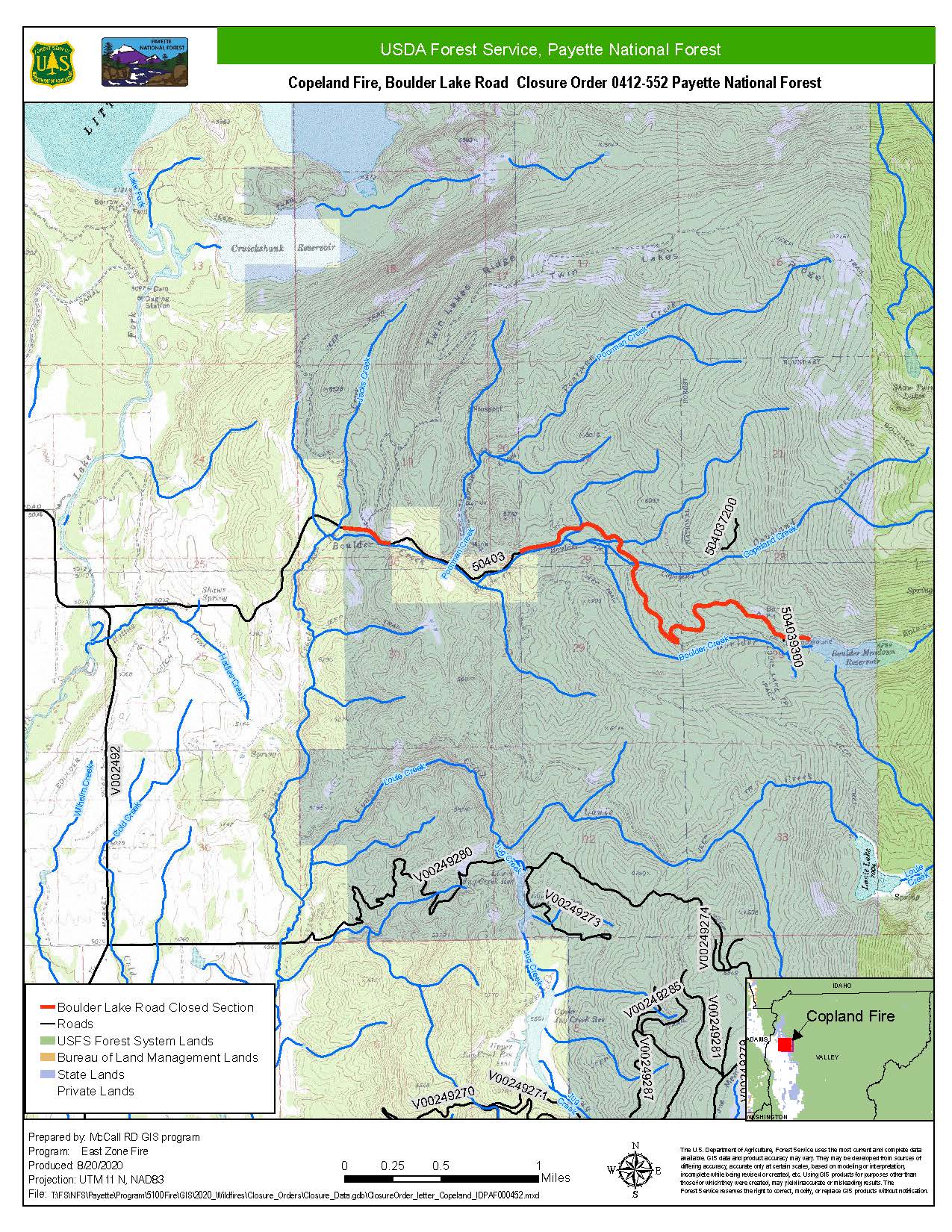
Boulder Lake Road is currently closed due to the danger of the fire, firefighter traffic, and aircraft dropping water and retardant. Please do not access these areas from Potter Lane, Paddy Flat Road, or other endowment, public, or private accesses, as this creates a safety issue for both the public and our firefighters.
For more information, visit InciWeb: https://inciweb.nwcg.gov/incident/7024/
##
Contact
Robbie Johnson, Idaho Department of Lands PIO
(208) 908-1786, pio@idl.idaho.gov
Idaho Department of Lands News Release August 22 2020
Related Incident:
Publication Type: News
For Immediate Release August 22, 2020 12:45 p.m. Mountain Time
(McCall) - Crews continue to work on limiting the spread of the Copeland Fire, and are keeping it in place over the 91-acre fire area. But they continue to be prepared for a possible increase in fire behavior in this forested area on Idaho endowment land approximately 5 miles east of McCall.
Additional ground crews are arriving today to assist. Crews are gaining on the fire line but are in tough country. Cooler weather conditions are forecast today with a chance of a few wind gusts this afternoon. Dry conditions are expected into Tuesday.
The Idaho Department of Lands (IDL) continues to urge the public to be aware of and avoid the Copeland Fire area. No structures are threatened, but it is a popular recreation area.
Boulder Lake Road is currently closed due to the danger of the fire, firefighter traffic, and aircraft dropping water and retardant. Please do not access these areas from Potter Lane, Paddy Flat Road, or other endowment, public, or private accesses, as this creates a safety issue for both the public and our firefighters.
Resources engaged in active suppression actions include aircraft, engines, a dozer, and 220 firefighters. There is a local Type 3 Incident Management Team on the fire.
For more information, visit InciWeb: https://inciweb.nwcg.gov/incident/7024/
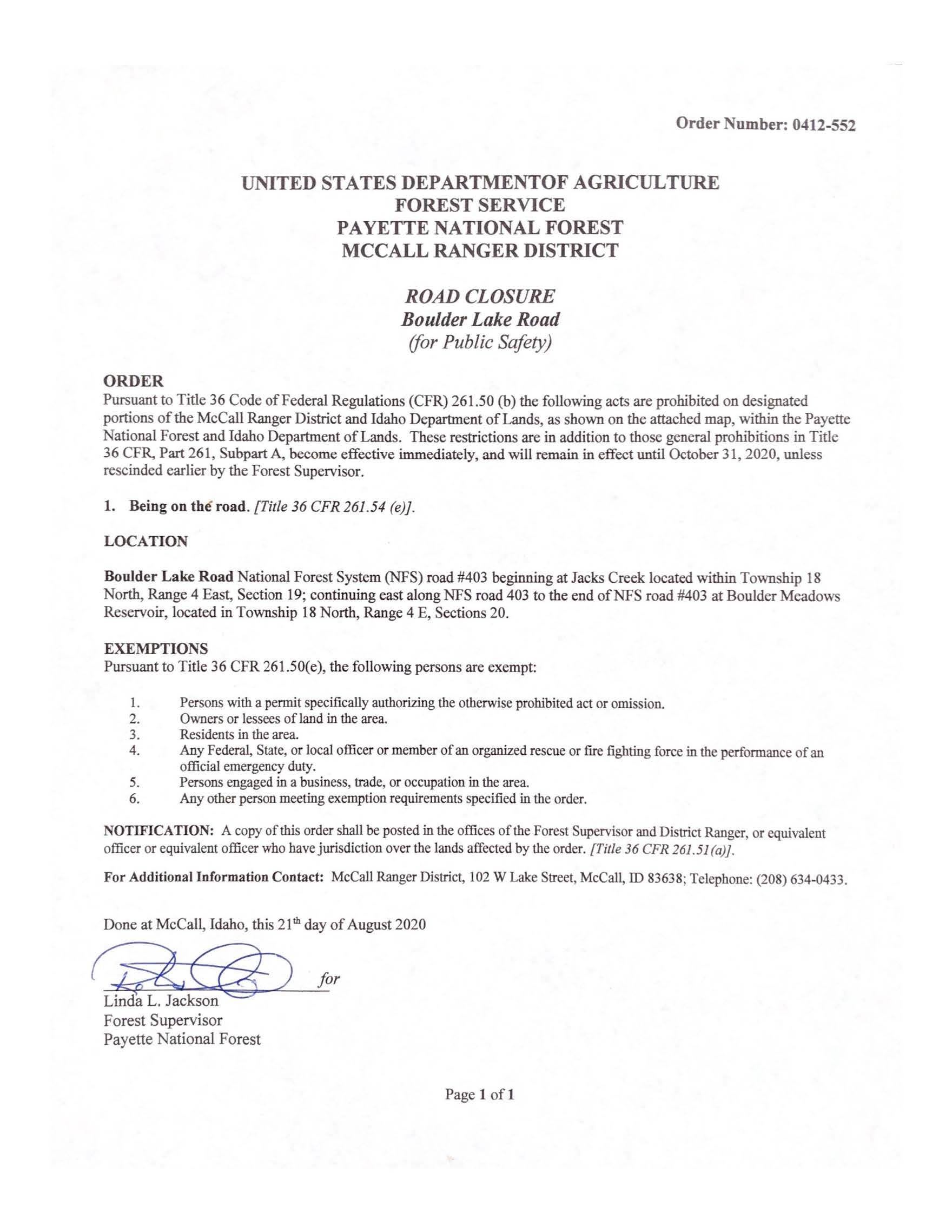
Boulder Lake Rd Closure
Related Incident:
Publication Type: Closures
Boulder Lake Road National Forest System (NFS) road #403 beginning at Jacks Creek located within Township 18 North, Range 4 East, Section 19; continuing east along NFS road 403 to the end of NFS road #403 at Boulder Meadows Reservoir, located in Township 18 North, Range 4 E, Sections 20 is closed to all non-firefighting or otherwise exempted traffic effective August 21, 2020. This closure is in effect until October 31, 2020 unless rescinded sooner by the Payette Forest Supervisor. See below for exemptions and additional information.
EXEMPTIONS
Pursuant to Title 36 CFR 261.50(e), the following persons are exempt:
1. Persons with a permit specifically authorizing the otherwise prohibited act or omission.
2. Owners or lessees of land in the area.
3. Residents of the area.
4. Any Federal, State or local officer or member of an organized rescue or fire fighting force in the performance of an official emergency duty.
5. Persons engaged in a business, trade, or occupation in the area.
6. Any other person meeting exemption requirements specified in the order.
NOTIFICATION: A copy of this order shall be posted in the offices of the Forest Supervisor and District Ranger, or equivalent officer or equivalent officer who have jurisdiction over the lands affected by the order. [Title 36 CFR 261.51(a)].
For Additional Information: Contact the McCall Ranger District, 102 W Lake Street, McCall, ID 83638; Telephone: (208) 634-0433.
Closure Order and Closure Map are posted in "Maps" portion of the incident.
Copeland Fire Closures Near McCall IDL News Release August 21
Related Incident:
Publication Type: News
Closures near Copeland Fire for public safety
For Immediate Release August 21, 2020 3:40 p.m. Mountain Time
(McCall) - The Idaho Department of Lands (IDL) is urging the public to be aware of and avoid the area near the Copeland Fire, burning approximately 5 miles east of McCall on Idaho Endowment Land. It is 90 acres in size.
Boulder Lake Road is currently closed, and all recreationists are urged to avoid this area due to the danger of the fire, firefighter traffic, and aircraft dropping water and retardant. Please do not access these areas from Potter Lane, Paddy Flat Road, or other endowment, public, or private accesses, as this creates a safety issue for both the public and our firefighters.
Resources engaged in active suppression actions include multiple helicopters, three engines, two dozers, and 140 firefighters including two hotshot crews. There is a local Type 3 Incident Management Team on the fire.
Cooler temperatures and higher relative humidity made for moderate fire activity overnight and has allowed firefighters to gain ground, but a warming trend is forecasted through the weekend.
For more information, visit InciWeb: https://inciweb.nwcg.gov/incident/7024/
##
Media Contact Robbie Johnson, Idaho Department of Lands PIO (208) 908-1786, pio@idl.idaho.gov
August 21 2020 News Release
Related Incident:
Publication Type: News
Suppression Efforts Continue
McCall, ID, August 21, 2020 – Fire crews and firefighting aircraft continue taking suppression tactics on lightning fires ignited by morning thunderstorms on August 19, 2020. Fires are located on lands managed by the Idaho Departments of Lands and Payette National Forest’s Krassel, McCall, New Meadows, Council and Weiser Ranger Districts.
Cooler temperatures and higher humidities over the fires today have helped firefighting efforts. A warming trend is expected through the weekend. Tropical moisture will be making its way into the area on Monday, bringing a chance of thunderstorms with it.
Fire Updates
Copeland: The Copeland fire is located 5 miles east of McCall near Shaw/Twin Lakes on Idaho Department of Lands land bordering the Payette National Forest, and is being managed by a local Type 3 Incident Management Team. It was mapped by infrared aircraft at 90 acres in the early morning hours of August 21, 2020. Cooler temperatures and higher relative humidity made for moderate fire activity overnight and has allowed firefighters to gain ground, but a warming trend is forecasted through the weekend. Resources engaged in active suppression actions include multiple helicopters, three engines, two dozers, and 140 firefighters including two hotshot crews. Valley County Sheriff has issued a road closure on county road 50403, the Boulder Lake Road at the intersection with Morrell Road. For more information, visit this page on Inciweb: https://inciweb.nwcg.gov/incident/7024/.
Wildhorse: The Wildhorse fire is located on the Council Ranger District, on the east side of Wildhorse River between Emery Creek and Blue Gulch in extremely steep terrain. The slope has made containment difficult and firefighters are still working on securing fireline to mitigate rollout. The fire is 9.2 acres and is staffed with 8 smokejumpers. County roads in the area remain open to the public.
Phoebe: The Phoebe fire is located on the Krassel Ranger District, 5 miles west of Yellow Pine. The fire is just over ¾ of an acre with no anticipated growth. Ten firefighters are on scene securing the line and working towards containment. There are no community or transportation impacts from this fire.
This will be the last report on the following fires, unless significant changes occur.
Council & Weiser Ranger Districts
Cold Spring – Located on the north side of Council Mountain. .25 acres, contained and controlled.
Silica – Located 3 miles west of Just Rite Campground, near Iron Mountain. .25 acres. Contained on the morning of August 21, 2020.
Southern Idaho Timber Protection Association (SITPA)
Red Ridge – Located on Red Ridge, 2 miles west of McCall, .10 acres, contained and controlled.
Fish Creek – Located 3 miles south of the Little Skihill. 0.5 acres, contained and controlled.
Use of unauthorized unmanned aerial systems (UAS), or drones, in a fire area endangers the lives of pilots and firefighters. Never fly unmanned aircraft over or near a fire. Remember, if you fly, we can’t.
Wildfires can produce high quantities of smoke. In the midst of fire activity, firefighters can do little to reduce smoke impacts. Affected communities should remain aware of smoke advisories and conditions. Learn more at https://airnow.gov
###
August 20 2020 News Release
Related Incident:
Publication Type: News
McCall, ID, August 20, 2020 – Fire crews and firefighting aircraft are responding to 13 wildfires on and around the Payette National Forest. Early morning thunderstorms on August 19, 2020 brought abundant lightning to the area starting multiple new fires that were reported throughout the day. Initial Attack actions on lands managed by the Idaho Departments of Lands and Payette National Forest’s Krassel, McCall, New Meadows, Council and Weiser Ranger Districts is ongoing.
A dry cold front will move in to the area today, bringing slightly cooler temperatures and light winds. With these cooler temps, and the smoke that has moved in from the California fires, fire activity is expected to moderate and will be helpful in gaining control of local fires. A warming trend is expected by the weekend with the next chance of thunderstorms expected on Monday.
Fire Updates
Copeland: The Copeland fire is now 93 acres and is burning on state lands bordering the Payette National Forest, McCall Ranger District. The fire is located 5 miles east of McCall in the Shaw/Twin Lakes area. There was moderate fire behavior through the night with smoldering, creeping, and minimal isolated interior torching. The fire will continue to be actively suppressed today. Resources assigned include multiple helicopters, three engines, two dozers, and 70 firefighters including two hotshot crews. Valley County Sheriff has issued a road closure on country road 50403, the Boulder Lake Road, north of the zipline. An infrared flight was conducted last night. For more information, visit this page on Inciweb: https://inciweb.nwcg.gov/incident/7024/.
Wildhorse: The Wildhorse fire is located on the Council Ranger District, on the east side of Wildhorse River between Emery Creek and Blue Gulch. The fire is 5-10 acres and currently staffed with eight smokejumpers.
Phoebe: The Phoebe fire is located on the Krassel Ranger District, 5 miles West of Yellow Pine. The fire is currently .75 acres. Ten firefighters worked late into the night to stop fire growth. Multiple spots were contained with the support of aviation resources through yesterday’s operational period.
Krassel Ranger District
East Fork – reported by local aviation assets on the morning of August 19, 2020. Estimated size .10 acres. Due to proximity and minimal fire activity this fire is sharing resources with the Phoebe incident.
Buck Horn – Located East of Rainbow Lakes/Buckhorn Lakes. Single tree lightning strike staffed with two helicopter rappellers, .10 acres, contained and controlled as of 8:00 am on August 20, 2020.
McCall Ranger District
Anderson Lake – Located 3 miles south of Lakefork Campground. Single tree lightning strike, staffed with two helicopter rappellers. .10 acres. Contained and controlled on evening of August 19, 2020.
Council & Weiser Ranger Districts
Ditch Creek – Located 2 miles south of Lafferty CG, .10 acres, contained
Cold Spring – Located on the north side of Council Mountain. .25 acres, 60% contained.
Rush Peak – Located near Cuddy Mountain, 4 miles east of Brownlee. .10 acres, controlled.
Silica – Located 3 miles west of Just Rite Campground, near Iron Mountain. .25 acres
Southern Idaho Timber Protection Association (SITPA)
Red Ridge – Located on Red Ridge, 2 miles west of McCall, .10 acres, controlled
Big Business – Located 3 miles north of No Business Look out, .10 acres, controlled
Fish Creek – Located 3 miles south of the Little Skihill. .5 acres, contained
Use of unauthorized unmanned aerial systems (UAS), or drones, in a fire area endangers the lives of pilots and firefighters. Never fly unmanned aircraft over or near a fire. Remember, if you fly, we can’t.
Wildfires can produce high quantities of smoke. In the midst of fire activity, firefighters can do little to reduce smoke impacts. Affected communities should remain aware of smoke advisories and conditions. Learn more at https://airnow.gov
###
Freeze Out Fire temporary area closure lifted
Related Incident:
Publication Type: News
Sheridan, WY, August 25, 2020- The ten-acre Freeze Out Fire, near Freeze Out Point off Forest System Road (FSR) 201 has been 100% contained and the temporary closure order in the Freeze Out area is lifted. Firefighters will continue to monitor the incident. The lightning caused fire burned in lodgepole pine and spruce mixed forest. No injuries were reported, and fire personnel are thankful for logistical support from local businesses.
If you have questions about the fire or closure, please contact the Bighorn National Forest Supervisor’s Office in Sheridan at 307-674-2600.
#
USDA is an equal opportunity provider, employer and lender.
Freeze Out Fire temporary area closure
Related Incident:
Publication Type: News
Sheridan, WY, August 19, 2020- The ten-acre Freeze Out Fire, near Freeze Out Point off Forest System Road (FSR) 201 has prompted officials to place a temporary closure order in the Freeze Out area. FSR 149, 150, 168, 161, 201, 198 and other routes are affected. The closure will begin on FSR 168 at the junction with FSR 149. The lightning caused fire has moderate potential to spread in lodgepole pine and spruce mixed forest.
If you have questions about the fire or closure, please contact the Bighorn National Forest Supervisor’s Office in Sheridan at 307-674-2600.
#
USDA is an equal opportunity provider, employer and lender.
Order BNG202005Fire Closure
Related Incident:
Publication Type: Closures
Order BNF-2020-05-Fire Closure
FOREST ORDER
Tongue District FIRE CLOSURE
Freeze Out Fire Area
PROHIBITIONS:
EXEMPTIONS:
Tonto National Forest Battles Lightning Fire in Rolls OHV Area
Related Incident:
Publication Type: News
Tonto National Forest Battles Lightning Fire in Rolls OHV Area
Location: Rolls OHV Area, Mesa RD Fuel Type: Grass/Brush
Size: 500 acres Date/Time Detected: 8/18/2020 8:00 pm
Cause: Lightning Containment: 0%
The Rolls Fire is burning in the Rolls OHV area northeast of the Butcher Jones Recreation Area onthe Mesa Ranger District, Lower Salt Recreation Area. The fire is approximately 500-1000acres and is lightning-caused. Mesa fire crews are on scene at this time and are planning afiring operation that will remove available fuels along Bush Hwy and Hwy 87, assisting withcontainment efforts.
During the firing operations this morning, Bush Hwy will be closed at Saguaro Lake (the lakewill remain open) and Hwy 87 will be restricted to 1 lane from the Bush Hwy exit north toFour Peaks Rd. Please drive safely through the area as firefighters will be working along thehighway.
No additional recreation site closures are associated with the Rolls Fire at this time, and noevacuations are in effect. With multiple lightning fires burning on the Tonto National Forest,firefighters are working to suppress these fires as quickly and safely as possible.
Stage 1 Fire Restrictions are currently in effect on the Tonto National Forest. Recreationaltarget shooting is currently prohibited on the Tonto National Forest as well. We are still infire season, so please be extremely careful when recreating in the forest.https://www.fs.usda.gov/alerts/tonto/alerts-notices
end