
July 27 Sand Creek Fire Update
Related Incident:
Publication Type: News
Sand Creek fire area closure lifted on the Pagosa Ranger District
Pagosa Springs, Colo., July 27, 2020 - A lightning storm on the afternoon of June 13th ignited the Sand Creek fire on the San Juan National Forest’s Pagosa Ranger District. The Sand Creek fire (107 acres) is 21 miles Northwest of Pagosa and is burning in the 2012 Little Sand fire perimeter in the Piedra Special Management Area. After assessing the fire from the ground, the decision was made not to engage due to a high density of hazardous snags, heavy fuel loads, and difficult terrain.
A forest closure went into effect on June 25th for the area surrounding the Sand Creek fire. This closure included the Sand Creek Trail (593), North Ridge Trail (594), and the Mosca road (NSFR 631). The forest closure has been lifted as of July 27th and all roads and trails are open.
The Sand Creek fire has received significant moisture and more is predicted. The fire is now at 60% containment. The fire will not be called out until Fire managers are certain no heat remains.
The Pagosa Fire Management Staff will provide additional fire updates if there is an increase in fire activity.
All offices on the San Juan National Forest are conducting business and providing visitor services virtually. For information on the San Juan National Forest, call (970) 247-4874, visit the forest website , or follow us on social media (Twitter and Facebook).
July 10 Sand Creek Fire Update
Related Incident:
Publication Type: News
Final Update for the Sand Creek Fire
Pagosa Springs, Colo., July 10, 2020 – The Sand Creek Fire has shown no significant growth over the last week. It is 20% contained at 104 acres. Most of the fire consumption has been limited to standing snags and dead fuel on the ground. The public may notice light smoke intermittently as dry days in the forecast encourage the fire to clean up unburned fuels within its current perimeter.
Management of the Sand Creek Fire will be transferred to the local Pagosa Ranger District today. Fire crews will continue to monitor the fire’s behavior and utilize helicopters for water drops if intense heat needs addressing.
Weather over the weekend is expected to be hot and dry. Please remember that fire danger across the region is rated as extreme. Fire restrictions are in place on the San Juan National Forest and within Archuleta County and Hinsdale County.
-USDA-
USDA is an equal opportunity provider, employer, and lender.
July 8 Sand Creek Fire Update
Related Incident:
Publication Type: News
Dry and Hot Conditions Expected Today
There is a Red Flag Warning in effect today. Temperatures are expected to be near 88 degrees with relative humidity dropping to the low teens. Winds could gust to around 25 mph in the afternoon. Fire danger across the region is rated as extreme. Fire restrictions are in place on the San Juan National Forest and within Archuleta County and Hinsdale County.
A Temporary Flight Restriction is in place over the Sand Creek Fire. Wildfires are a No Drone Zone. If you fly, we can’t. Every time a drone is spotted near the fire all aircraft are grounded until we can be sure the drone is clear of the area. For more information, visit http://knowbeforeyoufly.org.
Additional information about the Sand Creek Fire can be found at
-USDA-
USDA is an equal opportunity provider, employer, and lender.
July 6 Sand Creek Fire Update
Related Incident:
Publication Type: News
Cool Conditions over Sand Creek Fire
Pagosa Springs, Colo., July 6, 2020 – Cloud cover and thunderstorms over the weekend produced 0.14 inches of precipitation, higher relative humidity, and more moderate temperatures on the Sand Creek Fire. The fire was mapped at 103 acres. Fire behavior is expected to be minimal with only isolated areas of heat as partly cloudy skies continue today.
Firefighters plan to take advantage of cooler conditions and modest moisture to further limit fire growth with helicopter water drops. A helicopter will drop water on the top of the fire, southwest flank, where most of the isolated heat is, securing the edge before predicted Red Flag weather conditions on Tuesday and Wednesday. Two wildland fire modules continue to monitor the fire’s behavior and progression.
A forest closure is in effect around the fire area. The full text and a map of the closure can be found at https://inciweb.nwcg.gov/incident/closures/6790/.
Fire danger across the region is rated as extreme. Fire restrictions are in place on the San Juan National Forest and within Archuleta County and Hinsdale County.
A Temporary Flight Restriction is in place over the Sand Creek Fire. Wildfires are a No Drone Zone. If you fly, we can’t. Every time a drone is spotted near the fire all aircraft are grounded until we can be sure the drone is clear of the area. For more information, visit http://knowbeforeyoufly.org.
Additional information about the Sand Creek Fire can be found at:
InciWeb: https://inciweb.nwcg.gov/incident/6790
Facebook: facebook.com/2020SandCreekFire
Twitter: twitter.com/sanjuannf
All offices on the San Juan National Forest are currently conducting business and providing services virtually. For information on the San Juan National Forest, call (970 ) 247-4874, visit the forest website, or follow on social media (Twitter and Facebook).
July 4 Sand Creek Fire Update
Related Incident:
Publication Type: News
Little Movement on the Sand Creek Fire
A forest closure is in effect around the fire area. The full text and a map of the closure can be found at https://inciweb.nwcg.gov/incident/closures/6790/.
Fire danger across the region is rated as extreme. Fire restrictions are in place on the San Juan National Forest and within Archuleta County and Hinsdale County.
A Temporary Flight Restriction is in place over the Sand Creek Fire. Wildfires are a No Drone Zone. If you fly, we can’t. Every time a drone is spotted near the fire all aircraft are grounded until we can be sure the drone is clear of the area. For more information, visit http://knowbeforeyoufly.org.
Additional information about the Sand Creek Fire can be found at
-USDA-
USDA is an equal opportunity provider, employer, and lender.
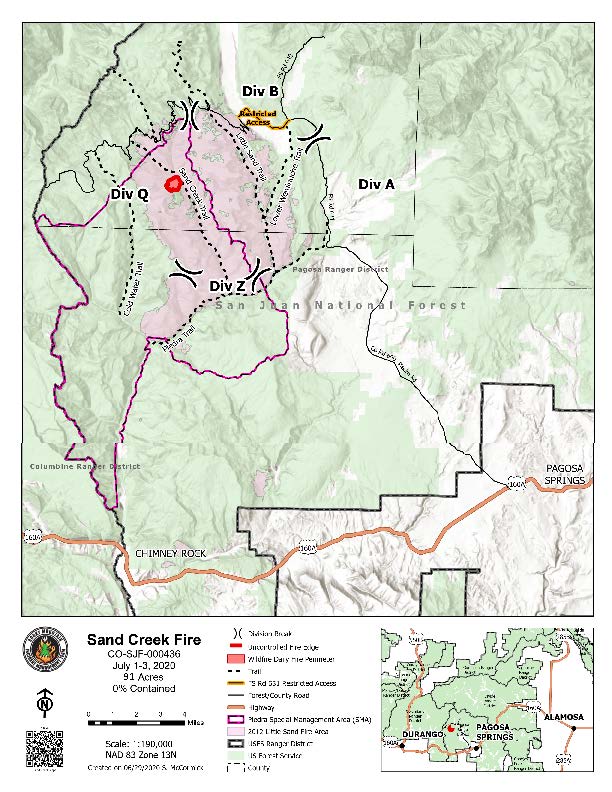
July 3 Sand Creek Fire Update
Related Incident:
Publication Type: News
Continued Progression of the Sand Creek Fire
A forest closure is in effect around the fire area. The full text and a map of the closure can be found at https://inciweb.nwcg.gov/incident/closures/6790/.
Fire danger across the region is rated as extreme. Fire restrictions are in place on the San Juan National Forest and within Archuleta County and Hinsdale County.
A Temporary Flight Restriction is in place over the Sand Creek Fire. Wildfires are a No Drone Zone. If you fly, we can’t. Every time a drone is spotted near the fire all aircraft are grounded until we can be sure the drone is clear of the area. For more information, visit http://knowbeforeyoufly.org.
Additional information about the Sand Creek Fire can be found at
-USDA-
USDA is an equal opportunity provider, employer, and lender.
July 2 Sand Creek Fire Update
Related Incident:
Publication Type: News
Slight Growth on the Sand Creek Fire
O
A forest closure is in effect around the fire area. The full text and a map of the closure can be found at https://inciweb.nwcg.gov/incident/closures/6790/.
Fire danger across the region is rated as extreme. Fire restrictions are in place on the San Juan National Forest and within Archuleta County and Hinsdale County.
A Temporary Flight Restriction is in place over the Sand Creek Fire. Wildfires are a No Drone Zone. If you fly, we can’t. Every time a drone is spotted near the fire all aircraft are grounded until we can be sure the drone is clear of the area. For more information, visit http://knowbeforeyoufly.org.
Additional information about the Sand Creek Fire can be found at
-USDA-
USDA is an equal opportunity provider, employer, and lender.
July 1 Sand Creek Fire Update
Related Incident:
Publication Type: News
Firefighters Continue Monitoring the Sand Creek Fire
A forest closure is in effect around the fire area. The full text and a map of the closure can be found at https://inciweb.nwcg.gov/incident/closures/6790/.
Fire danger across the region is rated as extreme. Fire restrictions are in place on the San Juan National Forest and within Archuleta County and Hinsdale County.
A Temporary Flight Restriction is in place over the Sand Creek Fire. Wildfires are a No Drone Zone. If you fly, we can’t. Every time a drone is spotted near the fire all aircraft are grounded until we can be sure the drone is clear of the area. For more information, visit http://knowbeforeyoufly.org.
Additional information about the Sand Creek Fire can be found at
-USDA-
USDA is an equal opportunity provider, employer, and lender.
June 30 Sand Creek Fire Update
Related Incident:
Publication Type: News
Sand Creek Fire Update
June 30, 2020 – 10:00 a.m.
Rocky Mountain Incident Management Team Black
Troy Hagan, Incident Commander
Information Office: (970) 426-5491
Hours of Operation: 8 a.m. - 8 p.m.
Sunday and Monday’s Winds Increase Sand Creek Fire Acreage
Current Situation: The Sand Creek Fire has grown to 88 acres. An infrared flight on Monday mapped the increased acreage that occurred on Sunday. The fire’s growth was primarily on the northwest corner, as the fire crept uphill through heavy fuels.
On Monday, gusty winds over the fire kept the fire creeping through heavy fuels, but little smoke was produced. The fire remains in the Little Sand Fire scar moving through heavy dead and downed fuels. On Tuesday, firefighters will utilize Unmanned Aerial Systems (UAS) to monitor the fire’s progression and validate safe possibilities if directly engaging the fire becomes an option.
Tuesday will be Team Black’s last day on the Sand Creek Fire. The fire will be turned back to the local unit and a Type 4 team, led by Incident Commander Jon Freeman from the Columbine Ranger District, will take command of the fire on Tuesday evening at 10 p.m.
Weather & Fuel Conditions: A dry cold front brings cooler temperatures and partly cloudy skies on Tuesday. As the front passes through the area, winds are expected to gust 25-28 mph. Temperatures will range in the low 70s. A Fire Weather Warning and a Red Flag Warning have been issued for the area until 8 pm.
Evacuations and Closures: A forest closure remains in effect around the fire area. The full text and a map of the closure can be found at https://inciweb.nwcg.gov/incident/closures/6790/. The Piedra River Trail (596), Little Sand Creek Trail (591), Lower Weminuche Trail (595), Coldwater Trail (597), and Coldwater Stock Trail (598) are all presently open. The Sand Creek Trail (593) and North Ridge Trail (594) are the only trails that are closed at this time. Mosca Road, NFSR 631 is also closed within the fire area. NFSR 631 east of the fire area is restricted to local traffic only. Please see today’s map for the extent of the Mosca Road closures and restrictions.
Fire Restrictions: Fire danger across the region is rated as extreme. Fire restrictions are in place on the San Juan National Forest. Archuleta County and Hinsdale County have both enacted Stage 1 Fire Restrictions.
Temporary Flight Restrictions: A Temporary Flight Restriction is in place over the Sand Creek Fire. Wildfires are a No Drone Zone. If you fly, we can’t. Every time a drone is spotted near the fire all aircraft are grounded until we can be sure the drone is clear of the area. For more information, visit http://knowbeforeyoufly.org.
For More Information:
InciWeb: https://inciweb.nwcg.gov/incident/6790
Facebook: facebook.com/2020SandCreekFire
Twitter: twitter.com/sanjuannf
Location: Approximately 20 miles northwest of Pagosa Springs, CO
Sand Creek Fire Statistics:
Size: 88 acres
Containment: 0%
Total Personnel: 163
Cause: Lightning
June 29 Sand Creek Fire Update
Related Incident:
Publication Type: News
Sand Creek Fire Update
June 29, 2020 – 10:00 a.m.
Rocky Mountain Incident Management Team Black
Troy Hagan, Incident Commander
Information Office: (970) 426-5491
Hours of Operation: 8 a.m. - 8 p.m.
Sand Creek Fire More Active on Sunday But No Growth Detected
Current Situation: Weekend storms and breezy weather increased fire activity on the Sand Creek Fire, creating more smoke than was seen late last week. The fire continues smoldering in the heavy fuels, slowly “cleaning up” the numerous fallen trees left from the 2012 Little Sand Fire. The Colorado Department of Fire Prevention and Control Multi-Mission Aircraft mapped the fire yesterday and found some heat within the fire’s perimeter but did not detect measurable growth. On Monday, firefighters will continue monitoring the Sand Creek Fire as it is expected to continue smoldering in the heavy fuels.
Weather & Fuel Conditions: Today, clouds will break slightly around 10 am. Winds will increase throughout the day, becoming gusty over the fire in the afternoon. Temperatures are expected to hover in the upper 70s and humidity will settle around 15 percent.
Evacuations and Closures: A forest closure is in effect around the fire area. The full text and a map of the closure can be found at https://inciweb.nwcg.gov/incident/closures/6790/. The Piedra River Trail (596), Little Sand Creek Trail (591), Lower Weminuche Trail (595), Coldwater Trail (597), and Coldwater Stock Trail (598) are all presently open. The Sand Creek Trail (593) and North Ridge Trail (594) are the only trails that are closed at this time. Mosca Road, NFSR 631 is also closed within the fire area. NFSR 631 east of the fire area is restricted to local traffic only. Please see today’s map for the extent of the Mosca Road closures and restrictions.
Fire Restrictions: Fire danger across the region is rated as extreme. Fire restrictions are in place on the San Juan National Forest. Archuleta County and Hinsdale County have both enacted Stage 1 Fire Restrictions.
Temporary Flight Restrictions: A Temporary Flight Restriction is in place over the Sand Creek Fire. Wildfires are a No Drone Zone. If you fly, we can’t. Every time a drone is spotted near the fire all aircraft are grounded until we can be sure the drone is clear of the area. For more information, visit http://knowbeforeyoufly.org.
For More Information:
InciWeb: https://inciweb.nwcg.gov/incident/6790
Facebook: facebook.com/2020SandCreekFire
Twitter: twitter.com/sanjuannf
Location: Approximately 20 miles northwest of Pagosa, CO
Sand Creek Fire Statistics:
Size: 71 acres
Containment: 0%
Total Personnel: 198
Cause: Lightning