
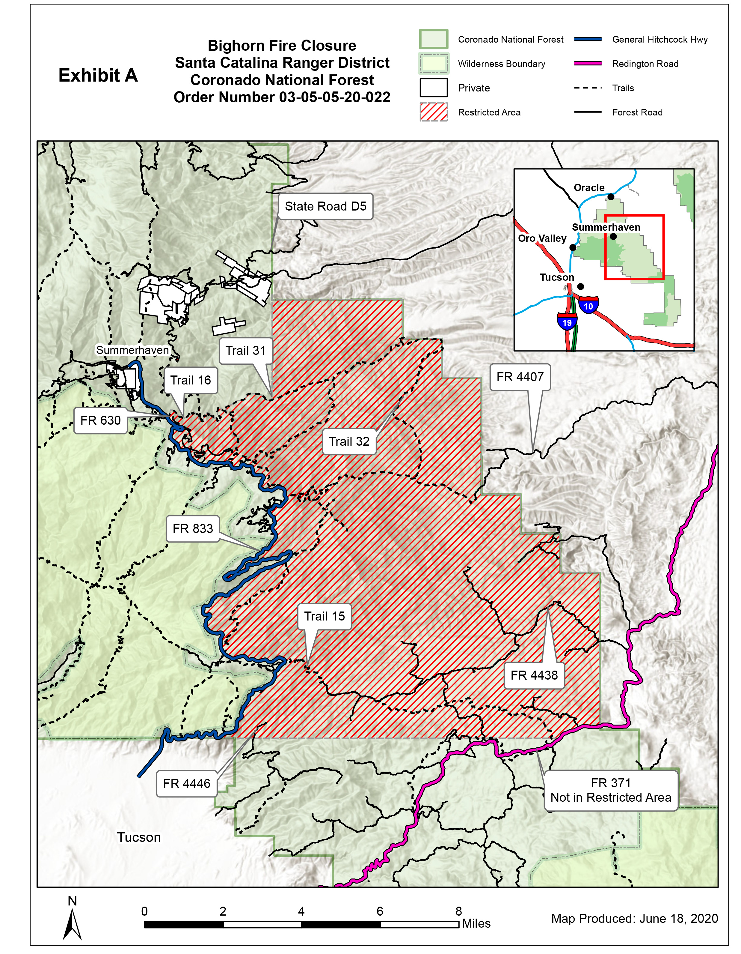
AREA CLOSURE Order Number 03050520022
Related Incident:
Publication Type: Closures

UNITED STATES DEPARTMENT OF AGRICULTURE
AREA CLOSURE
Order Number: # 03-05-05-20-022
PROHIBITIONS
36 C.F.R. § 261.53(e).
RESTRICTED AREA
PURPOSE
IMPLEMENTATION
 KERWIN DEWBERRY
 KERWIN S. DEWBERRY
Bighorn Fire June 19 2020 Morning Update
Related Incident:
Publication Type: News
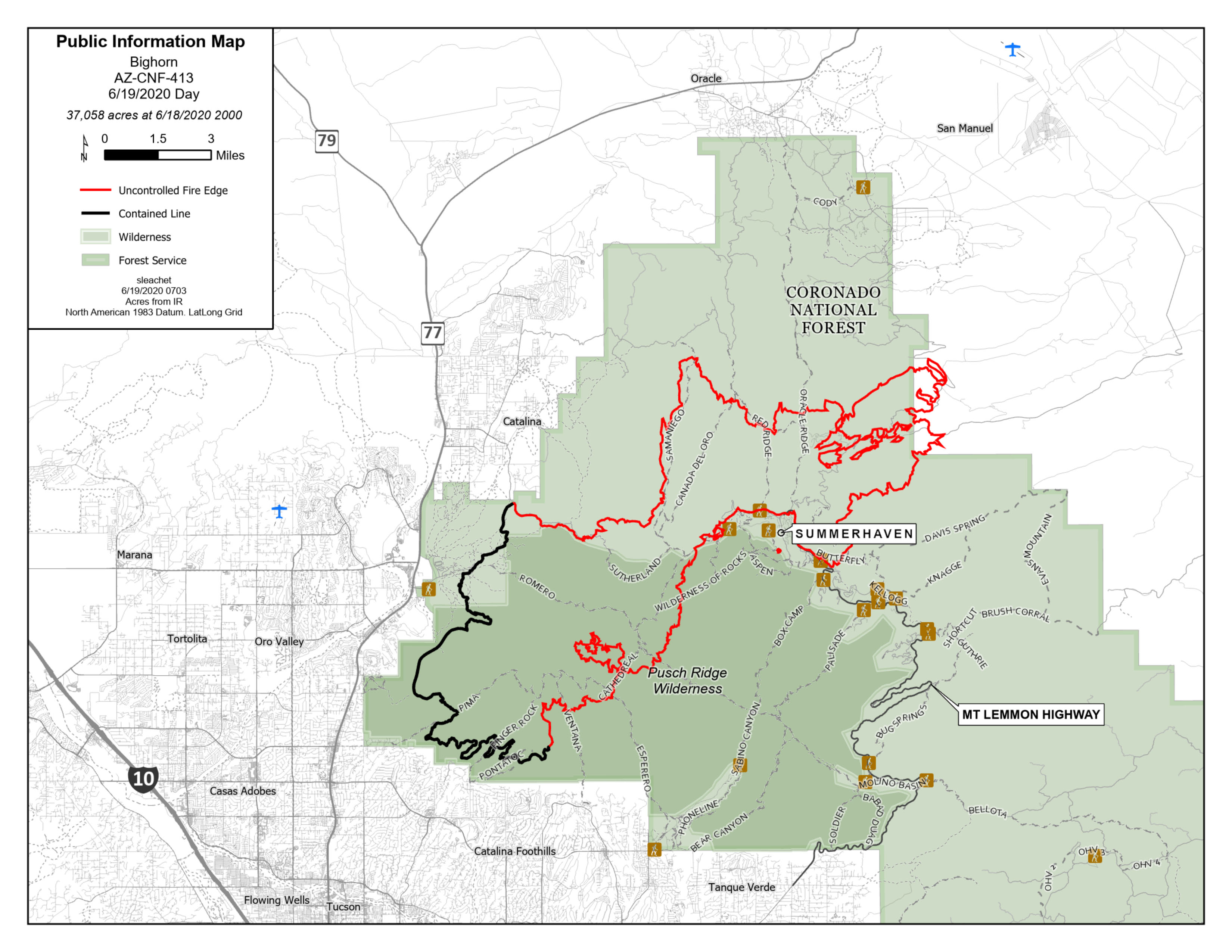
Bighorn Fire – June 19, 2020 Morning Update
Increase in smoke visibility today
Acres: 37,058
Percent Containment: 40%
Start Date: June 5, 2020
Cause: Lightning
Origin Location: Santa Catalina Mountains
Personnel: 924
Injuries: 3 minor heat-related illnesses
Jurisdiction: Coronado National Forest, including portions of the Pusch Ridge Wilderness
Resources: 8 hotshot crews, 12 Type 2 hand crews, 2 Type 1 engines, 27 Type 3 engines, 4 Type 4 engines, 31 Type 6 engines, 3 Type 1 helicopters, 1 Type 2 helicopter, 2 Type 3 helicopters, 11 water tenders, 6 bulldozers
Due to lower wind speeds, smoke will be more settled and visible in the communities around the fire area. Today’s weather will exemplify a typical June Southern Arizona day, with temperatures around 100 degrees, low humidity and mild winds.
Fire managers expect growth to the northeast in Cañada del Oro and Alder Canyons today. Crews working south of Oracle and San Manuel will tie in containment lines today, in preparation for additional firing operations this evening. Firefighters on Mt. Lemmon are using all available tools, including controlled burning, to protect the communities along the Catalina Highway.
As the high winds that had been keeping the fire burning up on Samaniego Ridge and at the top of Ventana Canyon subside, the public can expect to see fire move downslope at a moderate pace. The fire still has a long way to move before crews can successfully engage it on flat ground.
Wildfires are a No Drone Zone. If you fly, we can’t. A temporary flight restriction is in place over the fire area.
Evacuation Notices
GO - Evacuate
Mt. Bigelow & Lower Soldier HOA
Community of Summerhaven Willow Canyon
Peppersauce Canyon to Highjinks Road and Campo Bonito
SET – Be Alert
Community of Oracle
Portions of East Golder Ranch
Catalina Foothills between Alvernon Way and Sabino Canyon Road, North of Skyline Drive
READY – Prepare Now
Oro Valley area from Catalina State Park south to Magee Road
Tucson foothills area from First Avenue east to Alvernon Way
Visit pima.gov/bighorn for the most up-to-date information on evacuation notices, an interactive map, and county resources. Sign up to receive Pima County emergency alerts at myalerts.pima.gov and Pinal County alerts at pinalcountyaz.gov/emergencymanagement.
Closures: The Coronado National Forest closure order includes Sabino and Bear Canyons. Catalina State Park is closed. View the closure orders and maps at inciweb.nwcg.gov/incident/closures/6741/. Catalina Highway is closed to the public at milepost zero. Only residents and business owners may pass. Oracle Control Road is closed.
Fire Information Phone Line: (520) 276-8981 and (520) 329-7439, 8AM-8PM
Media Phone Line: (520) 329-7640, 8AM-8PM
InciWeb: inciweb.nwcg.gov/incident/6741/
Facebook: facebook.com/bighornfireinfo
Smoke Outlook: wildlandfiresmoke.net/outlooks/EasternArizona
###
Bighorn Fire June 18 2020 Evening Update
Related Incident:
Publication Type: News
Bighorn Fire – June 18, 2020 Evening Update
Firefighters take advantage of lighter winds
Acres: 31,208
Percent Containment: 40%
Start Date: June 5, 2020
Cause: Lightning
Origin Location: Santa Catalina Mountains
Personnel: 924
Injuries: 3 minor heat-related illnesses
Jurisdiction: Coronado National Forest, including portions of the Pusch Ridge Wilderness
Resources: 8 hotshot crews, 12 Type 2 hand crews, 2 Type 1 engines, 27 Type 3 engines, 4 Type 4 engines, 31 Type 6 engines, 3 Type 1 helicopters, 1 Type 2 helicopter, 2 Type 3 helicopters, 11 water tenders, 6 bulldozers
Tonight, crews will get a slight reprieve from the wind events that have been stoking the Bighorn Fire since Tuesday. Unfortunately, the humidity will remain too low to significantly reduce fire behavior. On Mt. Lemmon, firefighters are working in the Bear Wallow area down through Willow Canyon HOA, clearing fire line from the 2002 Bullock and 2003 Aspen Fires. This work will protect values at risk from the spot fires in Stratton and Alder Canyons that grew together over the course of the day. Air tankers continued to drop fire retardant throughout the day to limit spread of the fire burning in the Wilderness of Rocks.
The fire spread further northeast today reaching Pig Spring, with slow fire progression expected overnight. Depending on weather conditions, crews may conduct backburn operations south of Oracle and San Manuel tonight to create a buffer between the fire and those communities.
Fire burning on Samaniego Ridge and in Ventana Canyon will continue to be visible and slowly back downslope. Fire managers are confident in the preparatory work crews have done in those areas to hold the fire.
Evacuation Notices
GO - Evacuate
SET – Be Alert
READY – Prepare Now
· Mt. Bigelow & Lower Soldier HOA
· Community of Summerhaven
· Willow Canyon
· Peppersauce Canyon to Highjinks Road and Campo Bonito
· Community of Oracle
· Portions of East Golder Ranch
· Catalina Foothills between Alvernon Way and Sabino Canyon Road, North of Skyline Drive
· Oro Valley area from Catalina State Park south to Magee Road
· Tucson foothills area from First Avenue east to Alvernon Way
Visit pima.gov/bighorn for the most up-to-date information on evacuation notices, an interactive map, and county resources. Sign up to receive Pima County emergency alerts at myalerts.pima.gov and Pinal County alerts at pinalcountyaz.gov/emergencymanagement.
Closures: The Coronado National Forest closure order includes Sabino and Bear Canyons. Catalina State Park is closed. View the closure orders and maps at inciweb.nwcg.gov/incident/closures/6741/. Catalina Highway is closed to the public at milepost zero. Only residents and business owners may pass. Oracle Control Road is closed.
Fire Information Phone Line: (520) 276-8981 and (520) 329-7439, 8AM-8PM
Media Phone Line: (520) 329-7640, 8AM-8PM
InciWeb: inciweb.nwcg.gov/incident/6741/
Facebook: facebook.com/bighornfireinfo
Smoke Outlook: wildlandfiresmoke.net/outlooks/EasternArizona
###
GO Alert for Peppersauce Canyon to Highjinks RdCampo Bonito area of Oracle
Related Incident:
Publication Type: News
This is a joint message from the Pinal County Sheriff's Office and Pinal County Office of Emergency Management regarding the
A "Go! - Evacuate" alert has been issued for residents in the area of Peppersauce Canyon to Highjinks Rd./ Campo Bonito area of Oracle.
Residents should evacuate immediately to a shelter or with family or friends outside of the affected area.
The Red Cross has set up an evacuation center at the C.D.O. High School in Oro Valley. Large animal sheltering will be done at the Pinal County Fairgrounds at 512 Eleven Mile Corner, Casa Grande, AZ 85194.
An interactive map outlining fire alert zones is available here: http://bit.ly/PCBigHornFire
Questions for residents in the area can be directed to the Pinal County Citizen Contact Center at 520-509-3555.
If you choose to ignore this advisement, you must understand emergency services may not be able to assist you further. Follow instructions from emergency personnel, stay on designated evacuation routes and avoid closed areas.
Big Horn Fire Information June 20 2020
Related Incident:
Publication Type: Announcement
Both Pima and Pinal Counties have communities under a GO Alert Status. Find their information here.
Pima County Information Below:
NOTE: For evacuation information in PIMA County call the Pima County Sheriff's Office 520 351-4600.
https://www.facebook.com/pimasheriff/
https://www.facebook.com/PinalCountySO/
Pinal County Information Below:
Pinal County Interactive Maps
Pinal County Citizen Contact Center – 520-509-3555
Pinal County Sheriff’s Office Facebook link - https://www.facebook.com/PinalCountySO
Pinal County OEM Twitter link - https://twitter.com/home
Pinal County Fairgrounds Address – 512 Eleven Mile Corner, Casa Grande, AZ 85194
Pinal County Animal Control number – 520-509-3555
Bighorn Fire Links and information
will be updated as soon as information is available
Both Pima and Pinal Counties have communities under a GO Alert Status. Find their information here.
Pima County Information Below:
NOTE: For evacuation information in PIMA County call the Pima County Sheriff's Office 520 351-4600.
https://www.facebook.com/pimasheriff/
https://www.facebook.com/PinalCountySO/
Pinal County Information Below:
Pinal County Interactive Maps
Pinal County Citizen Contact Center – 520-509-3555
Pinal County Sheriff’s Office Facebook link - https://www.facebook.com/PinalCountySO
Pinal County OEM Twitter link - https://twitter.com/home
Pinal County Fairgrounds Address – 512 Eleven Mile Corner, Casa Grande, AZ 85194
Pinal County Animal Control number – 520-509-3555
Bighorn Fire Incident Links and information
Evening Update
Bighorn - June 20, 2020 Eve Ops Brief
Bighorn Fire - June 20, 2020 - Progression Map
Bighorn Fire - June 20, 2020 Info Map
June 20, 2020 Smoke Report
Bighorn Fire June 18 2020 Morning Update
Related Incident:
Publication Type: News
Bighorn Fire – June 18, 2020 Morning Update
Winds continue to challenge firefighters today
Acres: 31,208
Percent Containment: 40%
Start Date: June 5, 2020
Cause: Lightning
Origin Location: Santa Catalina Mountains
Personnel: 808
Injuries: 3 minor heat-related illnesses
Jurisdiction: Coronado National Forest, including portions of the Pusch Ridge Wilderness
Resources: 7 hotshot crews, 8 Type 2 hand crews, 2 Type 1 engines, 27 Type 3 engines, 1 Type 4 engines, 30 Type 6 engines, 3 Type 1 helicopters, 1 Type 2 helicopter, 4 Type 3 helicopters, 12 water tenders, 6 bulldozers
Yesterday, due to high winds, the fire made a large push to the north, growing by over 7,000 acres.
Today, fire managers anticipate the fire will move towards Charouleau Gap, depending on wind direction and temperatures. Fire crews and air support are in place preparing and widening fire lines for this expected spread of the fire. On Mt. Lemmon, the fire moved through Oracle Ridge and generated spot fires in Stratton Canyon. Expect highly visible smoke as those areas burn together today. Crews working overnight implemented controlled burns along the Catalina Highway corridor. Firing operations will continue today, if necessary, to protect values at risk.
Air operations including fixed-wing airtankers were up early this morning, dropping water and fire retardant to slow the fire’s spread. Winds will continue to be a factor today, but less so than yesterday. The fire burning in the Ventana Canyon area and along Samaniego Ridge will be monitored by air support today. Minimal downslope backing of the fire is anticipated in that area. Crews will tie together the two containment lines north of the fire perimeter to protect the communities of Oracle and San Manuel.
Ready, Set, GO! encourages Arizonans to get READY by preparing now for what threatens their community, be SET by maintaining awareness of significant danger and to GO, evacuate immediately when the danger is current.
Evacuation Notices
GO - Evacuate
SET – Be Alert
READY – Prepare Now
· Mt. Lemmon, Mt. Bigelow, and Lower Soldier HOA including the community of Summerhaven
· Willow Canyon area of Mt. Lemmon
· Community of Oracle
· Lower Mt. Lemmon from Organization Ridge Road to South Willow Canyon
· Portions of East Golder Ranch
· Oro Valley area from Catalina State Park south to Magee Road
· Tucson foothills area from First Avenue east to Alvernon Way
Visit pima.gov/bighorn for the most up-to-date information on evacuation notices, an interactive map, and county resources. Sign up to receive Pima County emergency alerts at myalerts.pima.gov and Pinal County alerts at pinalcountyaz.gov/emergencymanagement.
Closures: The Coronado National Forest closure order includes Sabino and Bear Canyons. Catalina State Park is closed. View the closure orders and maps at inciweb.nwcg.gov/incident/closures/6741/. Catalina Highway is closed to the public at milepost zero. Only residents and business owners may pass. Oracle Control Road is closed.
Fire Information Phone Line: (520) 276-8981 and (520) 329-7439, 8AM-8PM
Media Phone Line: (520) 329-7640, 8AM-8PM
InciWeb: inciweb.nwcg.gov/incident/6741/acebook: facebook.com/bighornfireinfo
Smoke Outlook: wildlandfiresmoke.net/outlooks/EasternArizona
###
GO Evacuate for Willow Canyon area of Mt Lemmon
Related Incident:
Publication Type: News
GO! – Evacuate
This is a combined message from the Pima County Office of Emergency Management and the Pima County Sheriff’s Department.
As part of the Ready, Set, GO! process, the Willow Canyon area of Mt. Lemmon is now in the “GO!” state and is being evacuated. If you are receiving this message, EVACUATE NOW. Safely move south on Catalina Highway and leave the mountain. Do not delay leaving the area.
The Pima County Sheriff’s Department will be going door to door to make contact with those affected residents who may not have received the message.
The general boundaries of the zone are the Lower Catalina Highway/Lower Mt. Lemmon Communities from Organization Ridge Road to South Willow Canyon.
Refer to the interactive map at http://bit.ly/ PCBigHornFire for greater detail.
An evacuation center is open at Sahuaro High School, 545 N Camino Seco in Tucson.
Large animal sheltering will be done at Rillito Racetrack, 4502 North 1st Avenue in Tucson.
Additional messaging will be sent as the situation changes.
Questions from residents in the area should be directed to 351-FIRE (3473)
Bighorn Fire information can be found here: http://www.pima.gov/ Bighorn
Pima County Emergency Alert information can be found here: https:// emergencyalerts.pima.gov/
Find out more about the Ready, Set, Go program here: https://ein.az.gov/ ready-set-go
Sign up for emergency alerts at myalerts.pima.gov and tell your neighbors about the program.
Bighorn Fire 6172020 Evening Update
Related Incident:
Publication Type: News
Bighorn Fire – June 17, 2020 Evening Update
Red Flag conditions spur fire growth
Acres: 23,892
Percent Containment: 40%
Start Date: June 5, 2020
Cause: Lightning
Origin Location: Santa Catalina Mountains
Personnel: 808
Injuries: 3 minor heat-related illnesses
Jurisdiction: Coronado National Forest, including portions of the Pusch Ridge Wilderness
Resources: 7 hotshot crews, 8 Type 2 hand crews, 2 Type 1 engines, 27 Type 3 engines, 1 Type 4 engine, 30 Type 6 engines, 3 Type 1 helicopters, 1 Type 2 helicopter, 4 Type 3 helicopters, 12 water tenders, 6 bulldozers
Yesterday evening’s burnout operations that created a buffer around the Mt. Lemmon Sky Center proved successful. Today, the fire reached that buffer and turned to the north, establishing in La Cañada del Oro Canyon. This generated a large volume of smoke that was visible today near the crest of Mt. Lemmon. This evening, firefighters will resume burnout operations to the switchback north of the observatory to keep the fire from impacting the community.
Fire burning along Samaniego Ridge, driven by high winds and dry brush, is producing substantial amounts of smoke visible from the Town of Oracle. Firefighters are securing containment lines to the north to hold the fire if it moves further down off the ridge. This includes reconstructing dozer line located south of Oracle from the 2003 Aspen Fire.
Ready, Set, GO! encourages Arizonans to get READY by preparing now for what threatens their community, be SET by maintaining awareness of significant danger and to GO, evacuate immediately when the danger is current.
Evacuation Notices
GO
SET
READY
· Mt. Lemmon, Mt. Bigelow, and Lower Soldier HOA north of Organization Ridge Road including the community of Summerhaven
· Lower Mt. Lemmon from Organization Ridge Road to South Willow Canyon
· Portions of East Golder Ranch near Catalina State Park
· Oro Valley area from Catalina State Park south to Magee Road
· Tucson foothills area from First Avenue east to Alvernon Way
Visit pima.gov/bighorn for the most up-to-date information on evacuation notices, an interactive map, and county resources. Sign up to receive Pima County emergency alerts at myalerts.pima.gov and Pinal County alerts at pinalcountyaz.gov/emergencymanagement. Residents may contact the Pima County Sheriff’s Department at 520-351-FIRE (3473) with evacuation questions.
Closures: The Coronado National Forest closure order includes Sabino and Bear Canyons. Catalina State Park is closed. Large portions of the Coronado National Forest, Santa Catalina Ranger District near the fire are restricted. View the closure orders and maps at inciweb.nwcg.gov/incident/closures/6741/. Catalina Highway is closed to the public at milepost zero. Only residents and business owners may pass. Oracle Control Road is closed.
Fire Information Phone Line: (520) 276-8981 and (520) 329-7439, 8AM-8PM
Media Phone Line: (520) 329-7640, 8AM-8PM
InciWeb: inciweb.nwcg.gov/incident/6741/
Facebook: facebook.com/bighornfireinfo
Smoke Outlook: wildlandfiresmoke.net/outlooks/EasternArizona
###
Mt Lemon Power Shut off and a return to READY for Some
Related Incident:
Publication Type: News
This is a combined message from the Pima County Office of Emergency Management and the Pima County Sheriff's Department.
In the interest of safety, Trico Electric Cooperative has turned off its generator and shut off power to Mt. Lemmon effective 5:30 p.m., 6-17-2020. This shutdown may affect areas that are outside of established evacuation zones.
Trico will provide updates at www.trico.coop and on social media.
Questions for Trico should be directed to Trico Dispatch at 520-744-2944.
Bighorn Fire information can be found here:http://www.pima.gov/Bighorn
Refer to the interactive map at http://bit.ly/PCBigHornFire
Fire specific Facebook page located here: facebook.com/bighornfireinfo
Pima County Emergency Alert information can be found here: https://emergencyalerts.pima.gov/
Find out more about the Ready, Set, Go program here: https://ein.az.gov/ready-set-go
This is a combined message from the Pima County Office of Emergency Management and the Pima County Sheriff's Department.
The Oro Valley area from Catalina State Park south to Magee Road, and the Tucson foothills area from 1st Avenue east to Alvernon Way, formerly set to “SET - Be Alert “ have both been downgraded to " READY - Prepare Now”. All residents who evacuated from these areas may return to their residences. Maintain vigilance and be aware of the hazards that can threaten your community.
Those areas previously in the "SET" stage of alert and not mentioned above will remain in the same status.
The Mt. Lemmon/Mt. Bigelow area remains under a "GO! - Evacuate" alert.
Stay aware of the latest news and information from public safety and public health officials.
Refer to the interactive map at http://bit.ly/PCBigHornFire
Questions from residents in the area should be directed to 351-FIRE (3473)
Bighorn Fire information can be found here: http://www.pima.gov/Bighorn
Fire specific Facebook page located here: facebook.com/bighornfireinfo
Pima County Emergency Alert information can be found here: https://emergencyalerts.pima.gov/
Find out more about the Ready, Set, Go program here: https://ein.az.gov/ready-set-go
Sign up for emergency alerts at myalerts.pima.govand tell your neighbors about the
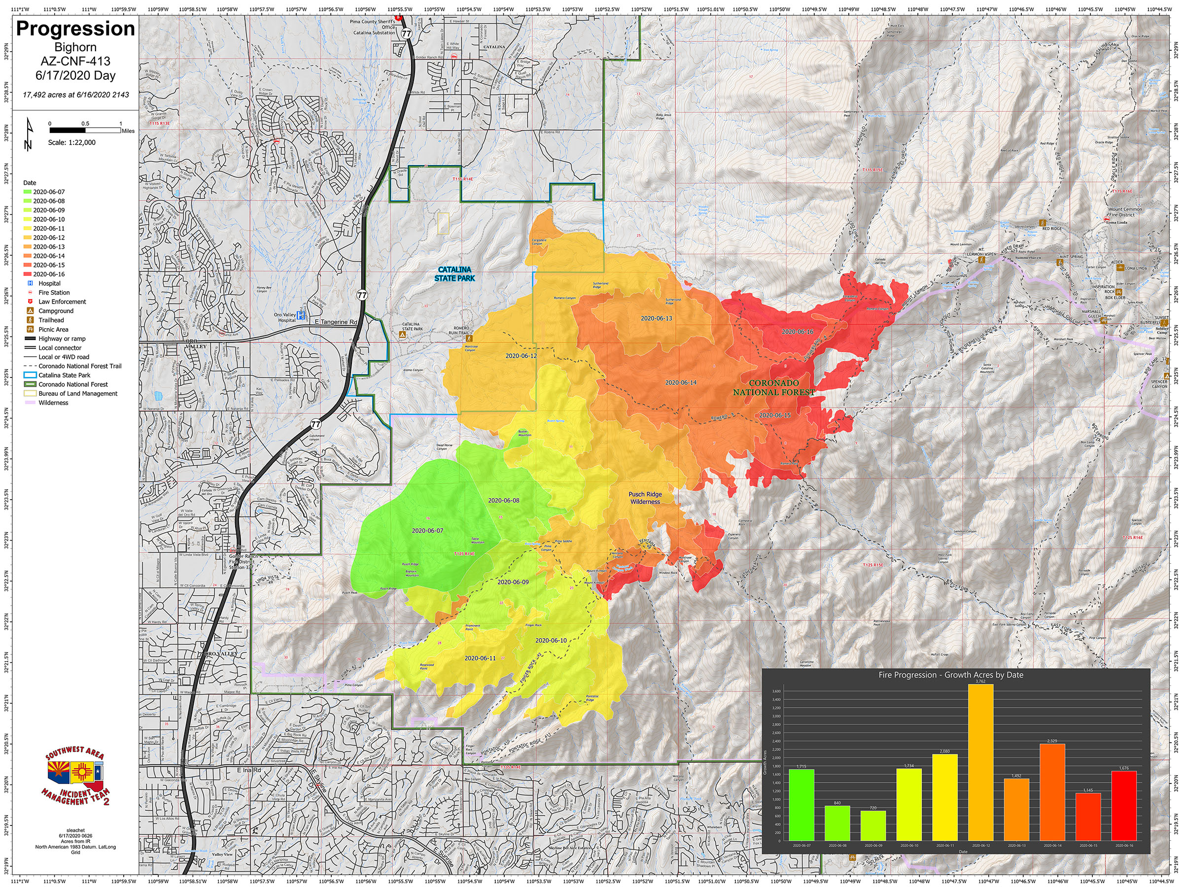
Bighorn Fire June 17 2020 Morning Update
Related Incident:
Publication Type: News
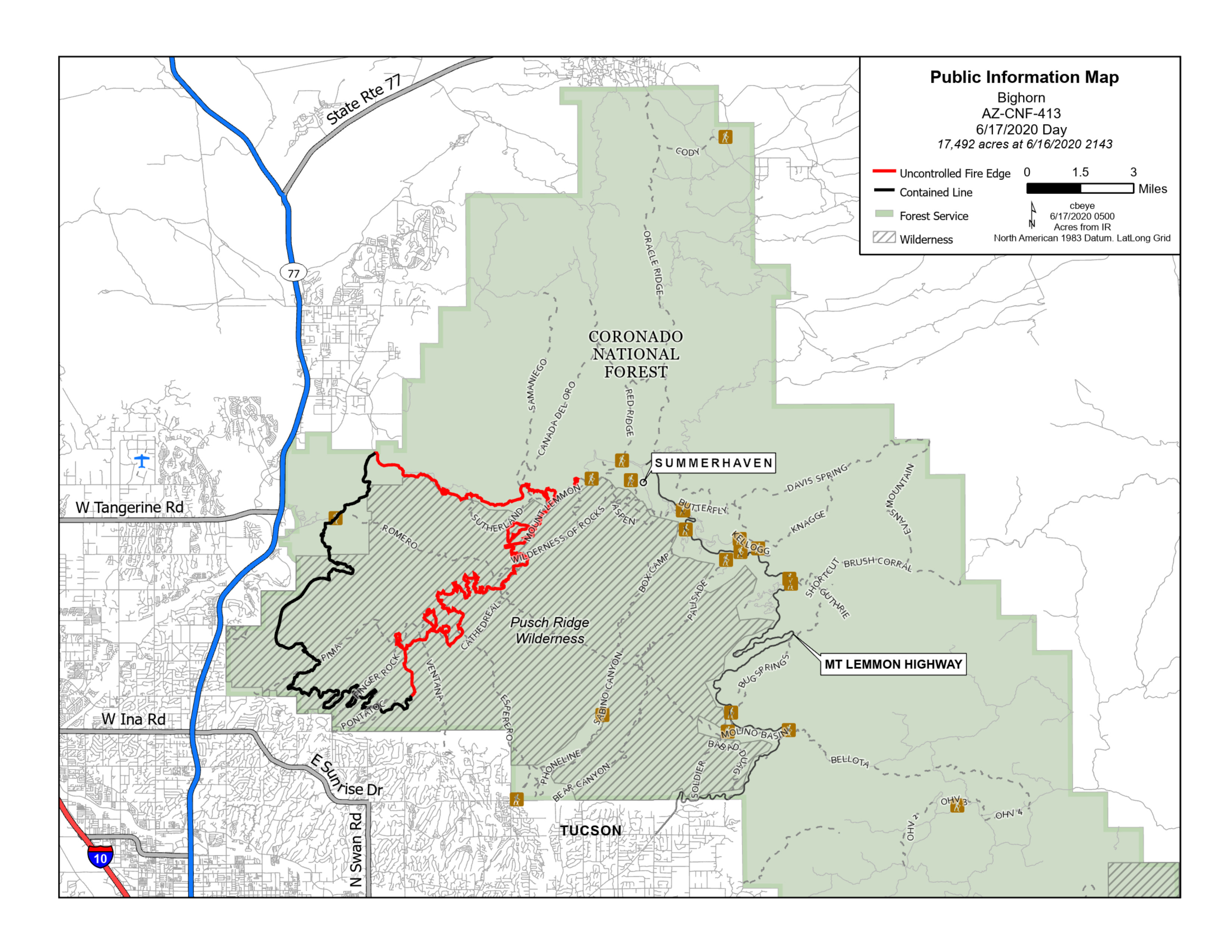
Bighorn Fire – June 17, 2020 Morning Update
Red Flag warning poses challenge to firefighters and air operations
Acres: 17,492
Percent Containment: 40%
Start Date: June 5, 2020
Cause: Lightning
Origin Location: Santa Catalina Mountains
Personnel: 700
Injuries: 3 minor heat-related illnesses
Jurisdiction: Coronado National Forest, including portions of the Pusch Ridge Wilderness
Resources: 8 hotshot crews, 7 Type 2 hand crews, 27 Type 3 engines, 1 Type 4 engine, 26 Type 6 engines, 4 Type 1 helicopters, 1 Type 2 helicopter, 2 Type 3 helicopters, 11 water tenders, 6 bulldozers
A Red Flag Warning will be in place today from 10AM to 8PM. These warnings are triggered when humidity is less than 15% combined with winds over 20mph sustained over a period of three or more hours. Air resources including helicopters and airtankers will be out in full force this morning before high winds may limit aircraft use this afternoon.
Yesterday evening crews working near the community of Summerhaven conducting burnout operations around Radio Ridge and the Mt. Lemmon Sky Center. They will continue firing operations this morning as weather allows. Crews are reinforcing fire line around the community and creating defensible space around homes and businesses.
Fire is established along Samaniego Ridge, and crews are closely monitoring activity around the communities of Saddlebrooke and East Golder Ranch. Firefighters are prepared to engage the fire if it begins to move down from the ridgelines.
Evacuation Notices:
· Mt. Lemmon, Mt. Bigelow, and Lower Soldier HOA north of Organization Ridge Road are in “GO – Evacuate” status, including the community of Summerhaven.
· Lower Catalina Highway/Lower Mt. Lemmon communities from Organization Ridge Road to South Willow Canyon are in the "SET - Be Alert" stage. Residents are encouraged to voluntarily relocate outside the affected area.
· SET notices for portions of the Catalina Foothills, Golder Ranch and Oro Valley remain in place.
Sign up to receive emergency alerts at myalerts.pima.gov. Visit pima.gov/bighorn for the most up-to-date information on evacuation notices, an interactive map, and county resources. Residents may contact the Pima County Sheriff’s Department at 520-351-FIRE (3473) with evacuation questions.
Closures: The Coronado National Forest closure order includes Sabino and Bear Canyons. Catalina State Park is closed. Large portions of the Coronado National Forest, Santa Catalina Ranger District near the fire are restricted. View the closure orders and maps at inciweb.nwcg.gov/incident/closures/6741/. Catalina Highway is closed to the public at milepost zero. Only residents and business owners may pass. Oracle Control Road is closed
Fire Information Phone Line: (520) 276-8981 and (520) 329-7439, 8AM-8PM
Media Phone Line: (520) 329-7640, 8AM-8PM
InciWeb: inciweb.nwcg.gov/incident/6741/
Facebook: facebook.com/bighornfireinfo
Smoke Outlook: wildlandfiresmoke.net/outlooks/EasternArizona
###