
GO NOTICE FROM PIMA COUNTY SHERIFFS OFFICE
Related Incident:
Publication Type: News
GO! - Evacuate
This is a combined message from the Pima County Office of Emergency Management and the Pima County Sheriff’s Department.
As part of the Ready, Set, GO! process, your area is now in the “GO!” state and is being evacuated. If you are receiving this message, EVACUATE NOW. Safely move south on Catalina Highway and leave the mountain. Do not delay leaving the area.
The general boundaries of the zone are Mt. Lemmon/ Mt. Bigelow north of Organization Ridge Rd, including Summerhaven.
The Pima County Sheriff’s Department will be going door to door to make contact with those affected residents who may not have received the message.
The general boundaries of the zone are Mt. Lemmon/ Mt. Bigelow north of Organization Ridge Rd, including Summerhaven.
Refer to the interactive map at http://bit.ly/PCBigHornFire
An evacuation center is open at Sahuaro High School, 545 N Camino Seco in Tucson. Large animal sheltering will be done at Rillito Racetrack, 4502 North 1st Avenue in Tucson.
Pima Animal Care Center will also be housing pets, the after-hours number is (520) 724-5900 and press 4. The daytime line is (520) 724-5961. More information can be found at: https://webcms.pima.gov/cms/One.aspx…
Additional messaging will be sent as the situation changes.
Questions from residents in the area should be directed to 351-FIRE (3473)
Bighorn Fire information can be found here: http://www.pima.gov/Bighorn
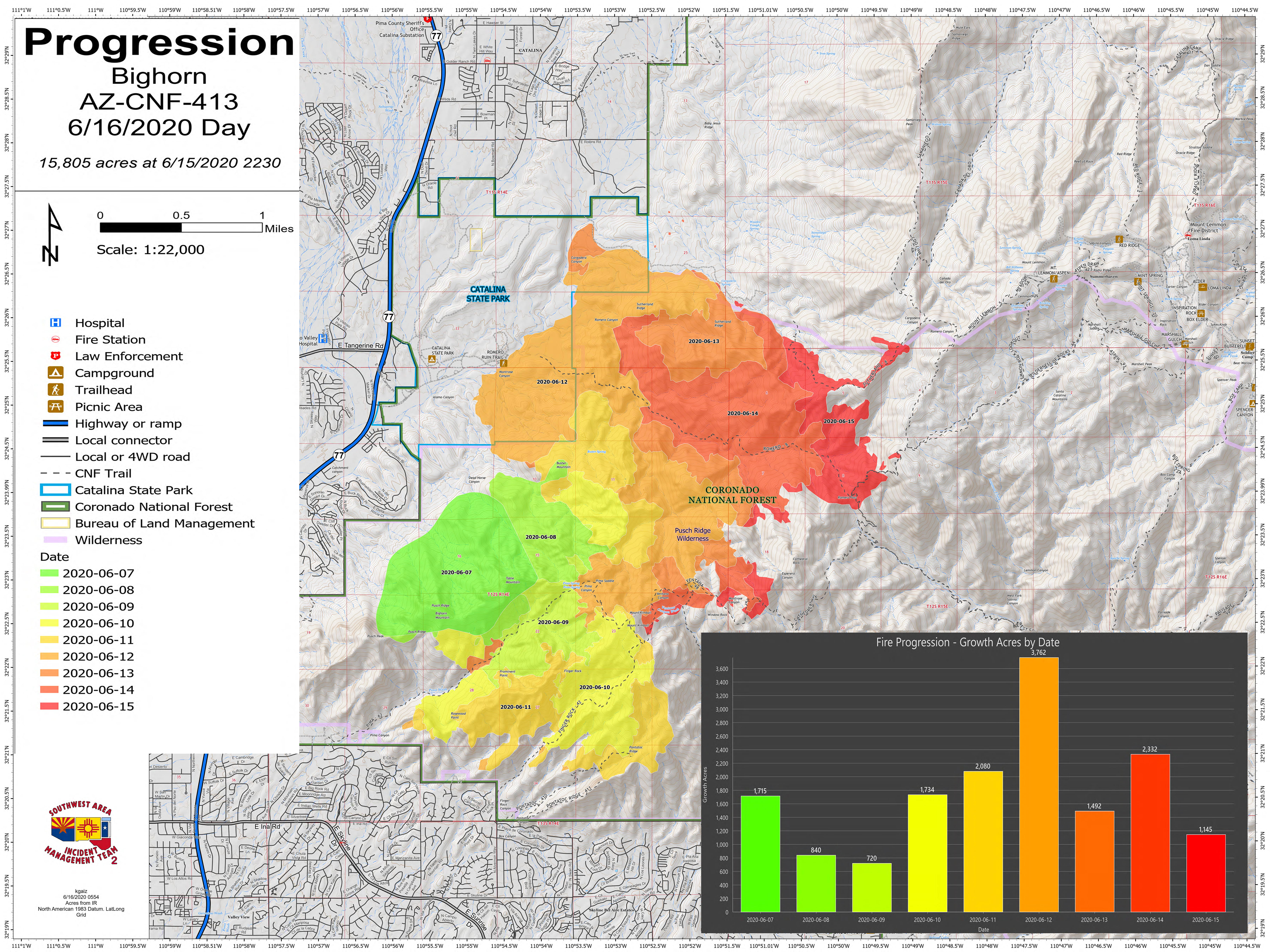
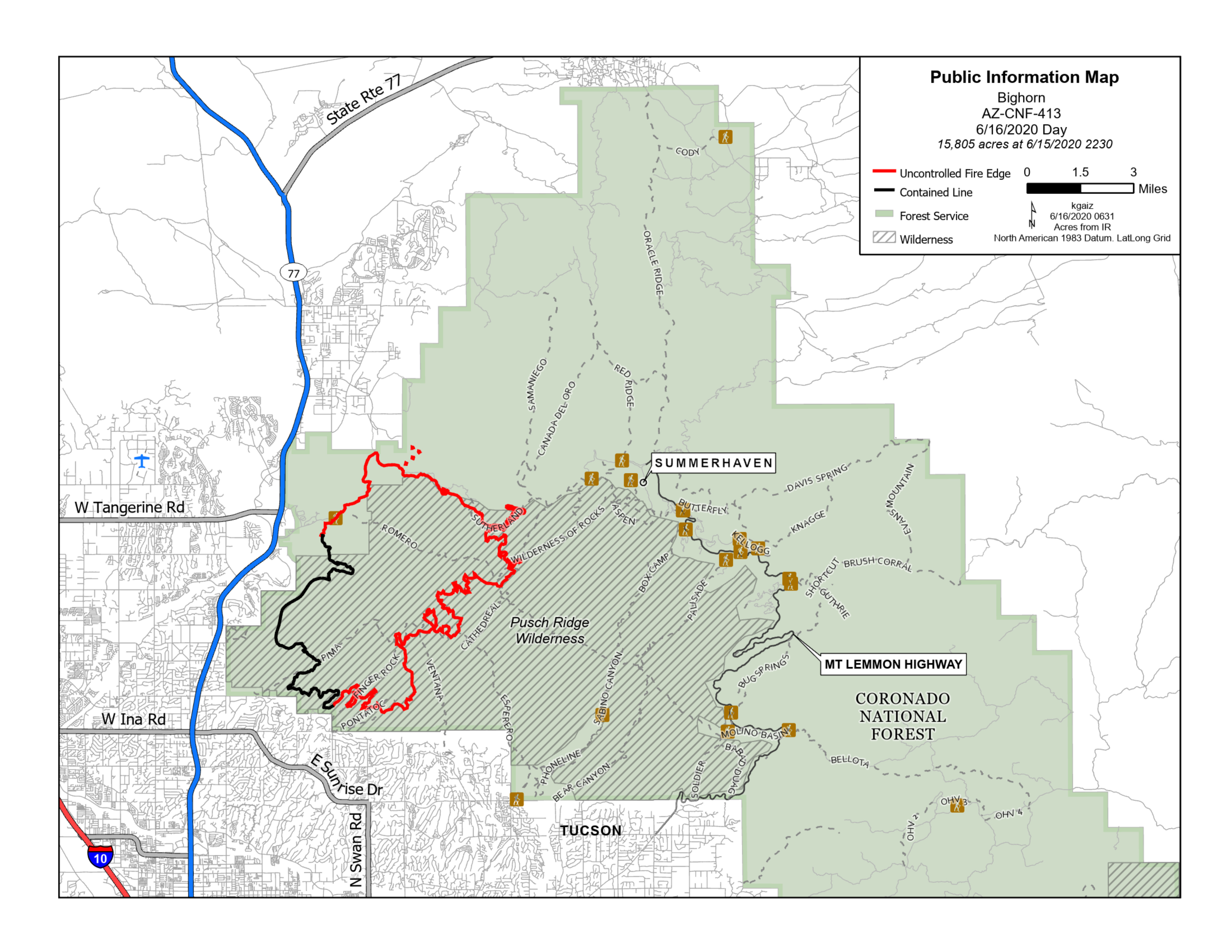
Bighorn Fire June 16 2020 Morning Update
Related Incident:
Publication Type: News
Bighorn Fire – June 16, 2020 Morning Update
Burnout operations continue through the night
Acres: 15,805
Percent Containment: 30%
Start Date: June 5, 2020
Cause: Lightning
Origin Location: Santa Catalina Mountains
Personnel: 729
Injuries: 3 minor heat-related illnesses
Jurisdiction: Coronado National Forest, including portions of the Pusch Ridge Wilderness
Resources: 7 hotshot crews, 8 Type 2 hand crews, 27 Type 3 engines, 1 Type 4 engine, 25 Type 6 engines, 4 Type 1 helicopters, 1 Type 2 helicopter, 2 Type 3 helicopters, 9 water tenders, 6 bulldozers
Crews took advantage of favorable weather conditions last night to conduct burnout operations on the northeast portion of the fire near the Trico powerline corridor. The goal of this burnout, conducted through aerial ignition using helicopters, is to slow the upslope momentum of the fire as it emerges from Romero Pass. Some lightning was observed over the forest last night and the Initial Attack crew stands at the ready to suppress any new ignitions.
The favorable humidity observed yesterday will dissipate and hot, dry conditions are expected to prevail, with strong southwest winds gusting up to 30 mph in the afternoon. Firefighters are working to create solid, defensible space around the community of Summerhaven, using heavy equipment such as bulldozers and excavators to bolster fuel breaks. Crews are placing bright orange portable water tanks known as pumpkins among the homes of the mountaintop town to feed sprinkler systems and strategically placed firehoses.
Firefighters continue to closely monitor the fire established at the top of Ventana Canyon and feel confident in the fire lines created to the south, if that fire were to move downslope. The public can expect to see crews working along the entire perimeter of the fire and are encouraged to drive with caution and make way for emergency vehicles.
Evacuation Notices:
· Mt. Lemmon and Mt. Bigelow are in “SET – Be Alert” status north of Organization Ridge Road Area, including Summerhaven.
· SET notices for portions of the Catalina Foothills, Golder Ranch and Oro Valley remain in place.
Sign up to receive emergency alerts at myalerts.pima.gov. Visit pima.gov/bighorn for the most up-to-date information on evacuation notices and county resources. Residents may contact the Pima County Sheriff’s Department at 520-351-FIRE (3473) with evacuation questions.
The Coronado National Forest closure order includes Sabino and Bear Canyons. Catalina State Park is closed. Large portions of the Coronado National Forest, Santa Catalina Ranger District near the fire are restricted. View the closure orders and maps at inciweb.nwcg.gov/incident/closures/6741/.
Catalina Highway is closed to the public at milepost zero. Only residents and business owners may pass.
Fire Information Phone Line: (520) 276-8981 and (520) 329-7439, 8AM-8PM
Media Phone Line: (520) 329-7640, 8AM-8PM
InciWeb: inciweb.nwcg.gov/incident/6741/
Facebook: facebook.com/bighornfireinfo
Smoke Outlook: wildlandfiresmoke.net/outlooks/EasternArizona
###
IMPORTANT NEW FOREST BIGHORN FIRE CLOSURES
Related Incident:
Publication Type: Announcement
Two new closure orders and accompanying maps from the Santa Catalina Ranger District, Coronado National Forest are under the closure tab.
AREA CLOSURE Order Number 03050520021
Related Incident:
Publication Type: Closures

UNITED STATES DEPARTMENT OF AGRICULTURE
U.S. FOREST SERVICE CORONADO NATIONAL FOREST
SANTA CATALINA RANGER DISTRICT
AREA CLOSURE
Order Number: # 03-05-05-20-021
PROHIBITIONS
Pursuant to 16 U.S.C. § 551 and 36 C.F.R. § 261.50(a), the following acts are prohibited within the area described in this Order (the “Restricted Area”) and as depicted on the attached map, hereby incorporated into this Order as Exhibit A, within the Santa Catalina Ranger District, Coronado National Forest, Pima County, Arizona.
1. Going into or being upon the restricted area for the protection of public health and safety.
36 C.F.R. § 261.53(e).
EXEMPTIONS
Pursuant to 36 C.F.R. § 261.50(e), the following persons are exempt from this Order:
1. Persons with a written Forest Service authorization specifically exempting them from the effect of this Order.
2. Any Federal, State, or Local Officer, or member of an organized rescue or firefighting resource in the performance of an official duty.
RESTRICTED AREA
The Restricted Area is within Township 13 S; Range 15 E portions of Sections 1-4, and 9-12, AND Township 12 S, Range 15 E all or part of sections 2-9, AND Township 12 S, Range 14 E all or part of sections 1 and 2, AND Township 11 S, Range 14 E sections 12, 13, 24, 25, 35, and
36, AND Township 11 S, Range 15 E sections 1-35, AND Township 11 S, Range 16 E, sections
3 through 10, 15-20, 29-30, AND Township 10 S, Range 15 E sections 1, 12-14, 19-36, AND Township 10 S, Range 16 E, sections 5-9, 16-21, 28-34 as depicted on the map attached hereto as Exhibit A.
The Restricted Area includes all lands within the following description:
All lands within Catalina State Park and from the Romero Trailhead east along the Romero Trail to its junction with the Wilderness of Rocks Trail. Wilderness of Rocks Trail east to its junction with the Aspen Trail. Aspen trail north to Radio Ridge Road (FR 18). FR 18 west to Ski Run Road (FR 11). Follow FR 11 north then east to General Hitchcock Highway (FR 833). FR 833 east to the Control Road (FR 38). FR 38 Northward to the Forest Boundary at the junction of State Road D5. Continue north, then west, and then south along the Forest Boundary to Catalina State Park as depicted on the map attached hereto as Exhibit A.
PURPOSE
The purpose of this Order is to close the Restricted Area where the Bighorn Fire is burning for the protection of public health and safety.
IMPLEMENTATION
1. This Order will be effective on June 15, 2020 at 7:00 pm, and shall remain in effect until August 15, 2020, or until rescinded, whichever occurs first.
2. A map identifying the Restricted Area is attached and made part of this Order as Exhibit A.
3. Any violation of this prohibition is punishable as a Class B misdemeanor by a fine of not more than $5,000 for individuals and $10,000 for organizations, or by imprisonment for not more than six (6) months, or both (see 16 U.S.C. § 551, 18 U.S.C. § 3571(b)(6), 18 U.S.C. § 3581 (b)(7)).
4. Further information regarding this Order may be obtained at the Santa Catalina Ranger District located in Tucson, Arizona, telephone number 520-749-7703, and at the Coronado National Forest Supervisor’s Office in Tucson, Arizona, telephone number 520-388-8300.
5. This Order supersedes any previous Orders prohibiting the same acts covered by this Order.
Done at Tucson, Arizona, this 15 day of June, 2020.
KERWIN DEWBERRY
Digitally signed by KERWIN DEWBERRY
![]() Date: 2020.06.15 20:15:14
Date: 2020.06.15 20:15:14
-07'00'
![]()
KERWIN S. DEWBERRY
Forest Supervisor Coronado National ForestClosure Order Number 03050520020
Related Incident:
Publication Type: Closures

UNITED STATES DEPARTMENT OF AGRICULTURE
U.S. FOREST SERVICE CORONADO NATIONAL FOREST
SANTA CATALINA RANGER DISTRICT
AREA CLOSURE
Order Number: # 03-05-05-20-020
PROHIBITIONS
Pursuant to 16 U.S.C. § 551 and 36 C.F.R. § 261.50(a), the following acts are prohibited within the area described in this Order (the “Restricted Area”) and as depicted on the attached map, hereby incorporated into this Order as Exhibit A, within the Santa Catalina Ranger District, Coronado National Forest, Pima County, Arizona.
1. Going into or being upon the restricted area for the protection of public health and safety.
36 C.F.R. § 261.53(e).
EXEMPTIONS
Pursuant to 36 C.F.R. § 261.50(e), the following persons are exempt from this Order:
1. Persons with a written Forest Service authorization specifically exempting them from the effect of this Order.
2. Any Federal, State, or Local Officer, or member of an organized rescue or firefighting resource in the performance of an official duty.
RESTRICTED AREA
The Restricted Area is within Township 13 S, Range 15 E portions of Sections 1-4 and 9-12, AND Township 13 S, Range 16 E portions of Sections 3-9, and 17-18, AND Township 12 S, Range 15 E all or part of sections 1-4, 9-16, 22-26, and 34-36 AND Township 12 S, Range 16 E
all or part of sections 4-10, 15-22, and 28-34, AND Township 11 S, Range 15 E sections 26, 35,
and 36, AND Township 11 S, Range 16 E, sections 10, 15-17, 20-22, and 27-34, as depicted on the map attached hereto as Exhibit A
The Restricted Area includes all lands within the following description:
From the northwest corner of the Sabino Canyon Recreation Area, northeast to Sabino Creek. Sabino Creek north to the Forest Trail 24. Forest Trail 24 northwestward to the junction with Forest Trail 5. Forest Trail 5 northeastward to its junction with the Forest Trail 44. Forest Trail northeastward to the junction with Forest Trail 93. Forest Trail 93 north to FR 18. FR 18 west to FR 11. Follow FR 11 north then east to FR 833. FR 833 east to FR 38. FR 38 northeastward to the Forest Boundary at the junction of State Road D5. Follow the Forest Boundary due south approximately 3.75 miles to Forest Trail 31. Follow Forest Trail 31 west to Forest Trail 16.
Forest Trail 16 west to FR 630. Follow FR 630 southwest to FR 833. FR 833 south until it exits the forest. Follow the forest boundary west and then north to the northwest corner of the Sabino Canyon Recreation Area.
PURPOSE
The purpose of this Order is to close the Restricted Area where the Bighorn Fire is burning for the protection of public health and safety.
IMPLEMENTATION
1. This Order will be effective on June 15, 2020 at 7:00 pm, and shall remain in effect until August 15, 2020 or until rescinded, whichever occurs first.
2. A map identifying the Restricted Area is attached and made part of this Order as Exhibit A.
3. Any violation of this prohibition is punishable as a Class B misdemeanor by a fine of not more than $5,000 for individuals and $10,000 for organizations, or by imprisonment for not more than six (6) months, or both (see 16 U.S.C. § 551, 18 U.S.C. § 3571(b)(6), 18 U.S.C. § 3581 (b)(7)).
4. Further information regarding this Order may be obtained at the Santa Catalina Ranger District located in Tucson, Arizona, telephone number 520-749-7703, and at the Coronado National Forest Supervisor’s Office in Tucson, Arizona, telephone number 520-388-8300.
5. This Order supersedes any previous Orders prohibiting the same acts covered by this Order.
Done at Tucson, Arizona, this 15 day of June, 2020.
KERWIN DEWBERRY
Digitally signed by KERWIN DEWBERRY
![]() Date: 2020.06.15 20:21:37
Date: 2020.06.15 20:21:37
-07'00'
![]()
KERWIN S. DEWBERRY
Forest Supervisor Coronado National Forest
Bighorn Fire June 15 2020 Evening Update
Related Incident:
Publication Type: News
Bighorn Fire – June 15, 2020 Evening Update
Increased humidity slows fire spread
Acres: 14,686
Percent Containment: 30%
Start Date: June 5, 2020
Cause: Lightning
Origin Location: Santa Catalina Mountains
Personnel: 729
Injuries: 3 minor heat-related illnesses
Jurisdiction: Coronado National Forest, including portions of the Pusch Ridge Wilderness
Resources: 7 hotshot crews, 8 Type 2 hand crews, 27 Type 3 engines, 1 Type 4 engine, 25 Type 6 engines, 4 Type 1 helicopters, 1 Type 2 helicopter, 2 Type 3 helicopters, 9 water tenders, 6 bulldozers
Humidity recovery will peak tonight at 42% on the valley floor and will contribute to temporarily slowing fire spread to the east. Crews are watching out for erratic winds, as dry thunderstorms are possible over the Santa Catalina Mountains. Fire will likely reach Window Rock and Cathedral Rock and begin backing into the upper reaches of Esperero Canyon to the south.
Today, a large contingent of engines and crews continued preparatory work around the community of Summerhaven. Firefighters utilized heavy equipment including bulldozers to construct fire line to the north, tying into an existing fire control line south of the Town of Oracle, remaining from the 2003 Aspen Fire.
Threats to the East Golder Ranch and Saddlebrook communities have greatly diminished due to the direct suppression work conducted by crews and air operations over the past several days. Residents will continue to see firefighters in the area patrolling and doing additional preparation around communities that border the north and south edges of the fire.
Evacuation Notices:
· Mt. Lemmon and Mt. Bigelow are in “SET – Be Alert” status north of Organization Ridge Road Area, including Summerhaven.
· SET notices for portions of the Catalina Foothills, Golder Ranch and Oro Valley remain in place.
The American Red Cross has closed the Emergency Evacuation Center at the Canyon Del Oro High School. Volunteers remain on standby and ready to assist as needs arise. Sign up to receive emergency alerts at myalerts.pima.gov.
Visit pima.gov/bighorn for the most up-to-date information on evacuation notices, an interactive map, and county resources.
The Coronado National Forest closure order has been expanded and now includes Sabino and Bear Canyons. Catalina State Park is closed. Large portions of the Coronado National Forest, Santa Catalina Ranger District near the fire are restricted. View the closure orders and maps at inciweb.nwcg.gov/incident/closures/6741/.
Catalina Highway is closed to the public at milepost zero. Only residents and business owners may pass.
Fire Information Phone Line: (520) 276-8981 and (520) 329-7439, 8AM-8PM
Media Phone Line: (520) 329-7640, 8AM-8PM
InciWeb: inciweb.nwcg.gov/incident/6741/
Facebook: facebook.com/bighornfireinfo
Smoke Outlook: wildlandfiresmoke.net/outlooks/EasternArizona
###
Bighorn Fire June 15 2020 Morning Update
Related Incident:
Publication Type: News
Bighorn Fire – June 15, 2020 Morning Update
Smoke visible as the Bighorn Fire spreads to higher elevations and heavier fuels
Acres: 14,675
Personnel: 673
Crews and equipment will be working north toward the town of Oracle, scouting for containment features and identifying values at risk.
Wildfires are a No Drone Zone. If you fly, we can’t. A temporary flight restriction is in place over the fire area. Every time a drone is spotted near the fire all aircraft are grounded until we can be sure the drone is clear of this area. Learn more at knowbeforeyoufly.org.
Fire Information Phone Line: (520) 276-8981 and (520) 329-7439, 8AM-8PM
Media Phone Line: (520) 329-7640, 8AM-8PM
InciWeb: inciweb.nwcg.gov/incident/6741/
Smoke Outlook: wildlandfiresmoke.net/outlooks/EasternArizonaoutlooks/EasternArizona
Summerhaven moves into SETBe Alert status as fire moves eastward
Related Incident:
Publication Type: News
Bighorn Fire – June 14, 2020 Evening Update
Summerhaven moves into “SET-Be Alert” status as fire moves eastward
Acres: 13,200
Percent Containment: 22%
Start Date: June 5, 2020
Cause: Lightning
Origin Location: Santa Catalina Mountains
Personnel: 633
Injuries: 3 minor heat-related illnesses
Jurisdiction: Coronado National Forest, including portions of the Pusch Ridge Wilderness
Resources: 6 hotshot crews, 5 Type 2 hand crews, 1 Type 1 engine, 26 Type 3 engines, 1 Type 4 engine, 26 Type 6 engines, 4 Type 1 helicopters, 1 Type 2 helicopter, 2 Type 3 helicopters, 11 water tenders, 7 bulldozers
The east flank of the Bighorn Fire is most active in the area between Buster Spring and Cargodera Spring, putting up thick smoke that is visible from the community of Summerhaven. Overnight, crews working on Mt. Lemmon will monitor the fire progression to the northeast and are prepared to initiate firing operations as needed to secure that section of the perimeter.
Pima County Sheriff’s Department has closed Catalina Highway to the public at milepost zero. Only residents and business owners may pass.
Fire will be wind-driven into the night, carried through grass and mesquite to the northeast. Winds may also stoke fire in upper reaches of Ventana and Esperero Canyons, with flames visible on the front range of the Santa Catalina Mountains.
Crews increased containment along the western and southern edges of the fire today, bringing the containment percentage up to 22%. Firefighters will continue to patrol those areas to ensure the containment lines are not compromised.
Evacuation Notices:
· The Pima County Sheriff’s Department has placed portions of Mt. Lemmon and Mt. Bigelow in “SET – Be Alert” status north of Organization Ridge Road Area, including Summerhaven. Prepare a “go kit” and include such items as prescription medication and important documents.
· Residents in the vicinity of East Golder Ranch Drive and East Rollins Road formerly set to “GO! – Evacuate” have been downgraded to "SET - Be Alert” by the Pima County Sheriff’s Department. Residents who evacuated may return to their residences.
· SET evacuation notices for portions of the Catalina Foothills, Golder Ranch and Oro Valley remain in place.
Residents are urged to sign up to receive emergency alerts at myalerts.pima.gov.
Visit pima.gov/bighorn for the most up-to-date information on evacuation notices and county resources.
Closures remain in effect. Catalina State Park is closed. Large portions of the Coronado National Forest, Santa Catalina Ranger District near the fire are restricted. View the closure order and map at inciweb.nwcg.gov/incident/closures/6741/.
Fire Information Phone Line: (520) 276-8981 and (520) 329-7439, 8AM-8PM
Media Phone Line: (520) 329-7640, 8AM-8PM
InciWeb: inciweb.nwcg.gov/incident/6741/
Facebook: facebook.com/bighornfireinfo
Smoke Outlook: wildlandfiresmoke.net/outlooks/EasternArizonaNew SET advisories under the
Related Incident:
Publication Type: Announcement
There are two new Set changes from the Pima County Sheriff's Office under the News Tab
Bighorn Fire East Golder Ranch Drive and East Rollins RoadReturn to SET
Related Incident:
Publication Type: News
Bighorn Fire: East Golder Ranch Drive and East Rollins RoadReturn to SET – Be Alert!
This is a combined message from the Pima County Office of Emergency Management and the Pima County Sheriff’s Department.
The East Golder Ranch Drive and East Rollins Road area formerly set to the “GO! – Evacuate,” has been downgraded to "SET - Be Alert”. Residents who evacuated may return to their residences. Residents should note the fire will appear to be in close proximity. Fire crews will continually access dangers and the fire’s behavior. It is imperative to remain alert.
Those areas previously in the "Set" stage of alert will remain in the same status.
Please remain vigilant in the "SET - Be Alert" stage and be prepared to evacuate if the status changes.
Stay aware of the latest news and information from public safety and public health officials.
This might be the only notice you receive. Emergency services cannot guarantee they will be able to notify everyone if conditions rapidly deteriorate. Be SET to GO.
Refer to the interactive map at
http://bit.ly/PCBigHornFire
Questions from residents in the area should be directed to 351-FIRE (3473)
Bighorn Fire information can be found here: http://www.pima.gov/Bighorn
Pima County Emergency Alert information can be found here: https://emergencyalerts.pima.gov/