
130 PM Decker Fire Update
Related Incident:
Publication Type: Announcement
Update on the Decker Fire:
Just after 12 Noon, the fire jumped the Rainbow Trail near Bear Creek in Division T. This happened as crews were working on lines to hold the fire west of the trail. The fire is burning northeast in the Bear Creek area. Firefighters have been pulled from the line.
An air tanker has been requested to drop retardant. We'll continue to update everyone as we receive the information.
Community Meeting in Howard
Related Incident:
Publication Type: Announcement
There will be a community meeting in Howard on Monday, October 14th at 6pm. It will be at the Howard Volunteer Fire Station. Leaders of the Rocky Mountain Type 1 incident management team and officials from Fremont County will be there to answer questions about the fire and pre-evacuation.
Decker Fire Update 101319
Related Incident:
Publication Type: News
October 13, 2019 (10 a.m.)
Fire Statistics:
Location: Fire started 9 miles south of, and is now burning 2 miles south of Salida, CO Start Date: September 8, 2019
Size: 7,326 acres Percent Contained: 30
Total Personnel: 755 Cause: Lightning
Resources Include: 8 Type-1 hand crews, 10 Type-2 hand crews, 27 engines, 4 dozers, 9 water tenders
Air Resources: 3 Type-1 (K-MAX, Blackhawk, Chinook), 1 Type-2, and 3 Type 3, and 2 fixed-wing aircraft
Special notes: A Red Flag Warning has been issued for the fire area again today from 11 am to 8 pm, because of expected gusty winds, extremely low humidity and warm temperatures. Please drive with caution as crews are continuing to backhaul hose line, pumps and portable water tanks from locations where the equipment is no longer needed.
Weather: Critical fire weather conditions are forecast for today. Maximum temperatures across the fire will reach 52-57 degrees, with clear skies. Humidity levels will drop to as low as 5%, with an average range of 5-10% across the fire. Strong west-southwest winds will kick up late in the morning, with gusts up to 35 mph in the slopes and valleys, and 35-40 mph on ridge tops. Heavy winds are forecast to continue throughout the day and early evening.
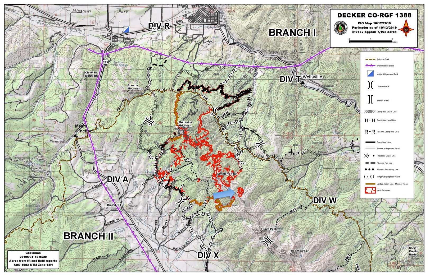
Current Situation: In the northeast, Division T firefighters initiated a large ground ignition operation along the edge of the Rainbow Trail fire line. Crews are working to burn a 3-mile-long stretch, which will strengthen the fire line by removing fuels from between the fire's edge and the line. Helicopters delivered bucket drops of water to help prevent the ignited fuels from crossing the trail. In Division W, a spot fire near Simmons Peak at the southeast corner of the fire grew in size and intensity yesterday. The fire is burning in a high, remote area and is being monitored. In Division A/X, Helicopter water drops were used to help cool an interior fire burning southeast of Methodist Mountain. That fire is consuming unburned fuel within the current fire boundary. Also in Division A/X, firefighters completed new sections of containment line along the west edge of the fire.
Today, the ground ignition operation along the Rainbow Trail in Division T will continue as conditions become favorable. Crews will be working toward each other from the north and south. This effort involves multiple ground crews, engines, and support from aerial operations. Chipping operations will take place along CR 101, as part of the effort to disperse fuels cut along the contingency line. In Division W, work will continue on new dozer line that will stretch further east from the division.
Division A/X and Division R will be working to patrol, secure line, mop-up and backhaul equipment. Crews will also focus on executing the Fire Suppression Repair plan. The plan is intended to restore, as much as possible, the natural conditions of vegetation, topography, and viewshed. These tasks include a series of immediate post-fire actions taken to repair impacts to the land from fire suppression tactics. The repair will minimize the impacts of soil erosion, transport of sediment into waterways and the negative impacts to wildlife including threatened and endangered species.
Structure Group will to monitor structures to the east in the Howard area and help with backhauling. The Night Shift will continue to monitor established fire lines. Several days of high winds, low humidities and clear skies have increased the probability of ignition for pockets of fuel in and near the fire. Crews will be extra vigilant when patrolling.
Closures and Public Safety: There are road closures in Chaffee, Fremont and Saguache County. Please respect closures. San Isabel Forest closures: https://tinyurl.com/SanIsabelClosures. Rio Grande Forest closures: https://tinyurl.com/RioGrandeClosures. BLM closures: Facebook @BLMColoradFire and https://tinyurl.com/BLMCLosure. For evacuation information, please contact the Chaffee County Sherriff’s Office: 719-539-2596, or Fremont County Emergency Management: 719-276-7416, 719-276-7418 or go to the Chaffee County Sheriff or Fremont County Sheriff Facebook pages and websites.
Decker Fire Update 101219
Related Incident:
Publication Type: News
October 12, 2019 (10 a.m.)
Special notes: Due to warmer temperatures, low humidity, and gusting winds, there will be a Red Flag Warning only over the fire today from 12:00 to 8:00 pm. Please drive with caution as firefighters are starting to backhaul over 100,000’ of hose, 150 pumps and 140 pumpkins (portable water tanks). Backhaul begins in neighborhoods where fire managers are confident that the fire threat has diminished.
Weather: Across the fire area today, skies will be clear with max temps 49-54 degrees. A minimum humidity of 6-10% with winds from the WSW 10-15 mph and gusts 25-35 mph will continue to dry the fuels. The extremely low humidity of 7% at Bear Creek early in the day will result in fuels being more receptive to fire earlier. Most visible smoke from yesterday was from firefighters burning out pockets of fuel to reinforce fireline.
Current Situation: On Division R, firefighters are monitoring the NW side of the fire that has been designated ‘minimal threat-limited action’ and back hauling structure protection equipment from the communities to the north. Near the east side at the Rainbow Trail crews will monitor fire line when the burn operation is implemented in Division T.
To the NE in Division T, chippers are completing work along CR 101. Friday, fire managers completed trials with plastic sphere dispensers (PSDs) to test receptivity of fuels. It was determined that the fuels were not ready to successfully implement the burn plan. Today the fuels are expected to be receptive; however, the burn tactics have been adjusted due to gusting winds. Crews will perform ground ignition to remove fuels between the fire’s edge and the Rainbow Trail contingency line. Seven crews and four engines will implement the burn plan using drip torches to lay fire on the ground and flare pistols to ignite fuels farther from the trail. Air resources will be available to assist as needed.
In Division W on the SE two hotshot crews will continue clean up of large downed trees near the fire line along Muddy Creek. To mitigate risks involved when working in remote, difficult terrain, a Rapid Extraction Module (REM) is staged on the Rainbow Trail.
Division X was monitored yesterday with no issues noted and Division A firefighters successfully burned fuels from the SE corner of the fire edge near Dorsey Creek. Today Divisions A and X will be combined (Division A/X) and will be working to patrol, mop-up and backhaul as needed. An excavator is knocking down hazard trees as fire suppression repair tasks begin.
Structure Group will be divided between backhauling equipment and monitoring structures to the east when the burn plan is being implemented. The Night shift continues to monitor established fire lines.
Closures and Public Safety: There are road closures in Chaffee, Fremont and Saguache County. Please respect closures. San Isabel Forest closures: https://tinyurl.com/SanIsabelClosures. Rio Grande Forest closures: https://tinyurl.com/RioGrandeClosures. BLM closures: Facebook @BLMColoradFire and https://tinyurl.com/BLMCLosure. For evacuation information, please contact the Chaffee County Sherriff’s Office: 719-539-2596, or Fremont County Emergency Management: 719-276-7416, 719-276-7418 or go to the Chaffee County Sheriff or Fremont County Sheriff Facebook pages and websites.
Fire Statistics:
Location: Fire started 9 miles south of, and is now burning 2 miles south of Salida, CO Start Date: September 8, 2019
Size: 7,105 acres Percent Contained: 15
Total Personnel: 851 Cause: Lightning
Resources Include: 10 Type-1 hand crews, 12 Type-2 hand crews, 32 engines, 4 dozers, 10 water tenders
Air Resources: 3 Type-1 (K-MAX, Blackhawk, Chinook), 1 Type-2, and 2 Type 3, and 2 fixed-wing aircraft
Smoke Advisory from the Colorado Department of Public Health Environment
Related Incident:
Publication Type: Announcement
At 4pm today, October 12th, the Colorado Department of Public Health & Environment issued a smoke advisory for areas near the Decker Fire. Please see below.
Air Quality Health Advisory for Wildfire Smoke
Issued for portions of central and southern Colorado
Issued at 4:00 PM MDT, Saturday, October 12, 2019
Issued by the Colorado Department of Public Health and Environment
Affected Area: southeastern Chaffee and northwestern Fremont Counties, including, but not limited to the communities of Salida, Cleora, Wellsville, Howard, Coaldale, and Cotopaxi.
Advisory in Effect: 4:00 PM MDT, Saturday, October 12, 2019 to 4:00 PM MDT, Sunday, October 13, 2019. .
Public Health Recommendations: If smoke is thick or becomes thick in your neighborhood you may want to remain indoors. This is especially true for those with heart disease, respiratory illnesses, the very young, and the elderly. Consider limiting outdoor activity when moderate to heavy smoke is present. Consider relocating temporarily if smoke is present indoors and is making you ill. If visibility is less than 5 miles in smoke in your neighborhood, smoke has reached levels that are unhealthy.
Outlook: Prolonged periods of moderate to heavy smoke are expected Saturday into Sunday afternoon from the Decker wildfire, located in far northeast Saguache County approximately 8 miles south of Poncha Springs. Although gusty winds may disperse smoke concentrations across the advisory area Saturday afternoon, smoke is expected to increase Sunday afternoon during the daytime hours. Gusty winds will increase fire activity on both days and overnight smoke will settle in low laying areas east of the fire. Smoke impacts are expected to continue through at least Sunday afternoon. Smoke will generally move to the east of the fire into southeastern Chaffee and northeastern Fremont county line, and could bring periods of heavy smoke to Poncha Springs, Smeltertown, Salida, Cleora, Wellsville, Howard, Coaldale, and Cotopaxi.
Afternoon Update 4pm Decker Fire
Related Incident:
Publication Type: Announcement
Here's an afternoon update on the Decker Fire:
Operations reports that ground ignitions in Division T on the northeast are going as planned. The burn operation will remove fuels between the fire’s edge and the Rainbow Trail contingency line. Crews are using drip torches to lay fire on the ground and flare pistols to ignite fuels farther from the trail. Seven crews and four engines are implementing the burn plan.
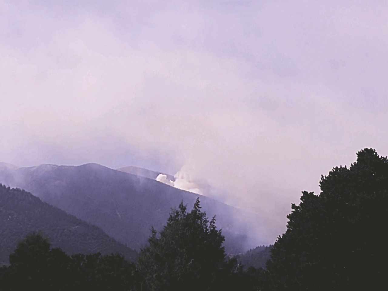
On the southeast corner, aerial crews are continuing to closely monitor the existing spot fire that gained in intensity this morning, and has increased in size to about 30 acres (shown in photo). The spot fire is located in remote wilderness area. Based on the advice of the Type 1 incident command team, and as a precaution, the Fremont County Sheriff's Office placed Howard area residents living in Zone 1 and Zone 2 on pre-evacuation status, as a precaution.
A Red Flag warning over the fire area is in effect until 8PM tonight, with strong, gusty winds coming out of the west-southwest
1139 AM Spot Fire Increased Activity Howard PreEvac Status
Related Incident:
Publication Type: Announcement
An existing spot fire on the southeast corner of the fire area has increased in size and intensity this morning. High winds from the west are pushing the fire to the east. The spot fire is in a hard-to-reach remote wilderness area.
We have aerial resources over the area, assessing the situation to determine the appropriate actions to employ.
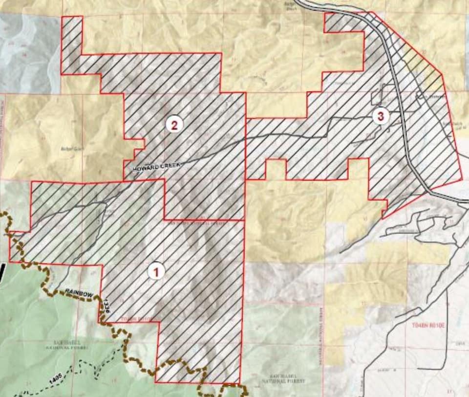
Upon advice of the Type 1 incident management team, Fremont County has just placed Zone 2 of the Howard area on PRE-EVACUATION status as of 11:30 AM today, as a precaution. Currently, Zones 1 and 2 are under pre-evacuation status.
The attached maps below show the location of the spot fire and the evacuation zones.
Decker Fire Update 101119
Related Incident:
Publication Type: News
October 11, 2019 (10 a.m.) Special notes: Burn plans are in place for 1500 acres of heavy fuels on the east side of the fire between the fire edge and Rainbow Trail. Yesterday, the firefighters executed test burns in the area. This carefully planned burn operation will be implemented when fire managers determine that the fuels and weather conditions are favorable for a safe, successful outcome. This could begin as early as today and be expected to last approximately three days. The burn will be conducted by ground crews and helicopters using a plastic sphere dispenser device(PSD). You can find a video on the DeckerFire2019 Facebook page that explains how the PSD dispenser works. https://tinyurl.com/deckerpsd Weather: The overnight low on the fire was +6 degrees; the low at ICP was +20. Today’s max temps will be 36-41 degrees with minimum humidity of 11-15% across the fire area. Winds will be from the NW in the morning, 5-10 mph with gusts to 15 mph until 10:00 am, then switching to the west a 12 mph with gusts to 20 mph. Ridgetop winds will be gusting 25-30 mph from the west after 12:00 pm. Fuels will continue to dry throughout the day, which may result in increased fire activity by mid-afternoon. Current Situation: In the north on Division R, fire line work is completed. To the northeast on Division T, chippers were utilized to disperse cut brush along CR 101. Fire managers also ran four drills to prepare for implementing the burn plan to remove fuels between the fire edge and the Rainbow Trail. Crews in Division W to the southeast inserted a hotshot crew and a REM (Rapid Extraction Module) team to work along the SE corner of the fire near Muddy Creek. Division X is complete and in monitor status. Division A is in mop-up and patrol status. Today firefighters in Division R will pull structure protection equipment that is no longer needed in the neighborhoods north of the fire. Firefighters in Division T will assess the conditions throughout the day to determine if necessary conditions exist to successfully implement the burn plan. In Division W to the SE, a hotshot crew will clean up some large downed trees near the fire line on the eastern corner by Muddy Creek. In Division X work is complete and is in monitor status. Division A will patrol and mop up as needed. Structure Group will be divided between backhauling equipment that is no longer needed and monitoring structures to the east when the burn plan is being implemented. The Night shift continues to monitor established fire lines. Closures and Public Safety: There are road closures in Chaffee, Fremont and Saguache County. Please respect closures. San Isabel Forest closures: https://tinyurl.com/SanIsabelClosures. Rio Grande Forest closures: https://tinyurl.com/RioGrandeClosures. BLM closures: Facebook @BLMColoradFire and https://tinyurl.com/BLMCLosure. For evacuation information, please contact the Chaffee County Sherriff’s Office: 719-539-2596, or Fremont County Emergency Management: 719-276-7416, 719-276-7418 or go to the Chaffee County Sheriff or Fremont County Sheriff Facebook pages and websites. Fire Statistics: Location: Fire started 9 miles south of, and is now burning 2 miles south of Salida, CO Start Date: September 8, 2019 Size: 7,172 acres Percent Contained: 15 Total Personnel: 877 Cause: Lightning Resources Include: 10 Type-1 hand crews, 15 Type-2 hand crews, 30 engines, 4 dozers, 10 water tenders Air Resources: 3 Type-1 (K-MAX, Blackhawk, Chinook), 1 Type-2, and 2 Type 3, and 2 fixed-wing aircraft
Pike San Isabel Forest Closure
Related Incident:
Publication Type: Closures
Order No. PSICC-2019-34
FOREST ORDER
USDA FOREST SERVICE PIKE and SAN ISABEL NATIONAL FORESTS Salida Ranger District
FIRE CLOSURE Rainbow Trail Decker Fire Area Pursuant to 16 United States Code (U.S.C.) § 551, and 36 Code of Federal Regulations (C.F.R.) § 261.50(a) and (b), the following acts are prohibited on all National Forest System lands within the Rainbow Trail Decker Fire Area on the Pike and San Isabel National Forest, Chaffee County, Fremont County, Colorado (the “Restricted Area”) and on all roads and trails located within the Restricted Area (the “Restricted Roads and Trails”). The Restricted Area and the Restricted Roads, Trails, and Trailheads are depicted on the attached map hereby incorporated into this order as Exhibit A. The purpose of this Order is to protect natural resources and public safety due to the continuing impacts of the Decker wildland fire. PROHIBITIONS: 1. Going into or being upon the Restricted Area. 36 C.F.R. § 261.53(e) and 36 C.F.R. § 261.52(e). 2. Being on the Restricted Roads. 36 C.F.R. § 261.54(e) 3. Being on the Restricted Trails. 36 C.F.R. § 261.55(a) EXEMPTIONS: Pursuant to 36 C.F.R. § 261.50(e), the following persons are exempt from this Order: 1. Any federal, state or local officer, or member of an organized rescue or firefighting force, in the performance of an official duty; 2. Persons with a USDA Forest Service permit specifically authorizing the otherwise prohibited act or omission. This Order supersedes, rescinds and replaces order PSICC-2019-30, becomes effective upon signature, and remains in effect until rescinded, or through December 31, 2019, whichever event occurs first. Done at Pueblo, Colorado. _____________________________ DIANA M. TRUJILLO Forest and Grassland Supervisor Pike and San Isabel National Forests Cimarron and Comanche National Grasslands Violation of these prohibitions is punishable as a Class B misdemeanor by a fine of not more than $5,000 for an individual or $10,000 for an organization, or imprisonment for not more than 6 months, or both. (16 U.S.C. § 551 and 18 U.S.C. §§ 3559 and 3571)
Decker Fire Update 101019
Related Incident:
Publication Type: News
October 10, 2019 (10 a.m.)
Special notes: Access to formerly evacuated areas is limited to residents only. This includes trails as there is still significant danger from falling trees and ash pits. BLM and Forest closures in the area remain in place. Bear Creek residents in Fremont County remain evacuated.
Due to the expected freezing temperatures and precipitation, fire managers will scout the fire access roads Thursday morning to determine if conditions prohibit safe driving conditions for fire personnel. Decker Fire Logistics teams have erected yurts and set up generators, heaters, lights, and provided antifreeze for equipment. All firefighters and crewmembers have been provided warm, dry places to sleep.
Weather: The high temperature this morning, in the mid 30s, will decrease to 20 degrees by 6:00 pm. SE valley winds 5-10 mph gusting to 15 mph will turn to the NW later in the day. Ridgetop winds from the SW 5-15 mph with gusts 25-30 mph will also change to the NW by 6:00 pm. The winds and low temperatures will create a possible wind chill of +5 to -15 degrees. Any precipitation (snow) will be expected between 9:00 AM and noon. Minimum humidity will be 60-65% across the fire area.
Current Situation: Yesterday, residents in Howard experienced smoky conditions from moderate fire behavior as strong winds reached the two ‘fingers’ on the eastern side of the fire. This resulted in the fire slowly burning toward the east. In the north on Division R, crews completed work along Co. Rd 124 and the Rainbow Trail. The dozer line to the west will remain the main control feature for this part of the fire. To the northeast on Division T, firefighters completed work along the handline running from the Columbine Trail south along the Rainbow Trail. Burn plans for this area have been completed and approved. Crews in Division W to the southeast completed work along contingency lines west of Howard. In Division X, to the south, handline and contingency line is complete. Crews in Division A continued to remove fuels from the path of the fire by applying limited amounts of fire to the ground between the fire and the dozer line. This burn operation created the smoke that winds pushed toward Salida yesterday.
Today, heavy fuels will continue to smolder, and strong wind gusts can transport embers. However, significant fire activity is not expected. Crews in Division R will pull brush and work to hold the completed line to the north. Firefighters in Division T will check plumbing along the handline that runs along the Rainbow Trail. The approved burn plans will be reviewed in preparation for firing operations when weather presents favorable conditions. In Division W to the SE firefighters have completed contingency lines. A small section of dozer line is being built along Muddy Creek to the fire edge for access. In Division X, crews will monitor completed direct, indirect and contingency lines. Firefighters in Division A hold and improve completed lines. Structure protection groups in Howard will protect equipment (pumps, hoses, etc.) from freezing weather. Initial attack resources for new starts are included in the Structure Group. The Night shift will continue to monitor established fire lines.
Today’s map has a new brown line. This brown line indicates a section of the fire edge that presents ‘minimal threat’ from fire spread and ‘limited action’ needed. These lines are in areas of extreme terrain where fire is not expected to progress; thus it does not warrant the risk exposure to firefighters. These areas will be monitored closely; air resources may be used to limit fire progress as needed.
Closures and Public Safety: There are road closures in Chaffee, Fremont and Saguache County. Please respect closures. San Isabel Forest closures: https://tinyurl.com/SanIsabelClosures. Rio Grande Forest closures: https://tinyurl.com/RioGrandeClosures. BLM closures: Facebook @BLMColoradFire and https://tinyurl.com/BLMCLosure. For evacuation information, please contact the Chaffee County Sherriff’s Office: 719-539-2596, or Fremont County Emergency Management: 719-276-7416, 719-276-7418 or go to the Chaffee County Sheriff or Fremont County Sheriff Facebook pages and websites.
Fire Statistics:
Location: Fire started 9 miles south of, and is now burning 2 miles south of Salida, CO Start Date: September 8, 2019
Size: 7,034 acres Percent Contained: 14
Total Personnel: 904 Cause: Lightning
Resources Include: 10 Type-1 hand crews, 15 Type-2 hand crews, 30 engines, 4 dozers, 10 water tenders
Air Resources: 3 Type-1 (K-MAX, Blackhawk, Chinook), 1 Type-2, and 2 Type 3, and 2 fixed-wing aircraft