
BLMSan Luis Valley Field Office Decker Fire Temp Emergency Road Closures
Related Incident:
Publication Type: Closures
October 5, 2019
LLCOF03000
Temporary Emergency Road Closure on Public Lands in Saguache County, Colorado
Summary: Notice is hereby given that a temporary emergency closure for roads in relation to the Decker Fire is in effect on public lands administered by the San Luis Valley Field Office, Bureau of Land Management (BLM). The purpose of these road closures is to ensure public and firefighter safety and are solely for firefighting operations only. The temporary emergency road closure includes the public lands roads located south of Poncha Pass and east of Highway 285 to the roads in the vicinity of Yankee Creek and Rock Creek. This includes the intersection of BLM Road 5350 and Forest Service (FS) Road 982 and the southern- most part of FS Road 982 as it enters BLM. All roads on BLM lands in this area are closed to all vehicle traffic.
Dates: This temporary emergency road closure will be in effect immediately until it is rescinded. For information or questions related to the San Luis Valley Field Office, please contact Melissa Garcia at 719-239-0494.
Supplementary Information: This temporary road closure affects all BLM system and non-system routes within the attached Map. The BLM will post closure signs at main entry points in this area. Maps of the affected area and other documents associated with this closure are available at the San Luis Valley Field Office, 1313 East Highway 160, Monte Vista, Colorado 81144. Under the authority of Section 303 (a) of the Federal Land Policy and Management Act of 1976 (43 U.S.C. 1733 (a)), 43 CFR 8360.0-7 and 43 CFR 8364.1, the BLM will enforce the following rule (s) in the area identified in this closure notice.
Prohibitions: You must not enter or use BLM system and non-system routes located east of Highway 285 as identified by on the ground signing and maps referred to in this document.
Exemptions: The following persons are exempt from this order: Federal, state, and local officers and employees in the performance of their official duties; members of organized rescue or fire-fighting forces in the performance of their official duties; and persons with written authorization from the BLM.
Penalties: Any person who violates the above rules and/or restriction may be tried before a United States Magistrate and fined no more than $1,000, imprisoned for no more than 12 months, or both. Such violations may also be subject to the enhanced fines provided for by 18 U.S.C. 3571.
BLMRoyal Gorge Field Office Decker Fire Public Lands Closure Oct4
Related Incident:
Publication Type: Closures
October 4, 2019
LLCOF02000
Temporary Emergency Closure of Public Lands in Fremont and Chaffee County, Colorado
Summary: Notice is hereby given that a temporary emergency closure for public and firefighter safety in relation to the Decker Fire is in effect on public lands administered by the Royal Gorge Field Office, Bureau of Land Management (BLM). The temporary emergency closure includes public lands located south and southwest of Highway 50 in the Salida and Wellsville area including areas such as Methodist Mountain and Bear Creek.
Dates: This temporary emergency closure will be in effect immediately until it is rescinded. For information or questions related to the Royal Gorge Field Office, please refer to the RGFO website at https://www.blm.gov/office/royal-gorge-field-office contact Kalem Lenard at 719-269-8538.
Supplementary Information: This temporary closure affects BLM lands located south and southwest of Highway 50 in the Salida and Wellsville, Colorado area. The BLM will post closure signs at main entry points in this area. Maps of the affected area and other documents associated with this closure are available at the Royal Gorge Field Office, 3028 E. Main Street, Canon City, Colorado 81212. Under the authority of Section 303 (a) of the Federal Land Policy and Management Act of 1976 (43 U.S.C. 1733 (a)), 43 CFR 8360.0-7 and 43 CFR 8364.1, the BLM will enforce the following rule (s) in the area identified in this closure notice.
Prohibitions: You must not enter or use BLM lands located south and southwest of US Highway 50 in the Salida and Wellsville, Colorado area as identified by on the ground signing and maps referred to in this document.
Exemptions: The following persons are exempt from this order: Federal, state, and local officers and employees in the performance of their official duties; members of organized rescue or fire-fighting forces in the performance of their official duties; and persons with written authorization from the BLM.
Penalties: Any person who violates the above rules and/or restriction may be tried before a United States Magistrate and fined no more than $1,000, imprisoned for no more than 12 months, or both. Such violations may also be subject to the enhanced fines provided for by 18 U.S.C. 3571.
Decker Fire Update 10519
Related Incident:
Publication Type: News
October 5, 2019 (10 a.m.)
Special notes: There is a PUBLIC MEETING about the Decker Fire TODAY at 10am: Salida SteamPlant, 220 W. Sackett Ave.
HUNTERS are advised to carefully check Forest and BLM closures before scouting or hunting; some units are in or near the fire.
Weather: There is a RED FLAG WARNING in effect from 11am to 8pm. Predicted conditions will be dry with strong winds throughout the day and humidities dipping into the low teens. Temps 45-55F. Winds from the W/NW, 25-35 mph, gusts 40-45. In the afternoon, winds will shift and come from due west. Gusts of 50-55 mph are possible across the fire area between 3pm and 6pm. Gusts of 30-40 mph will persist through the night. Fuels are dry and receptive to embers. The combination of dry fuels, low humidities, and high winds creates significant potential for spotting. Once established, wind-driven spot fires could spread quickly.
The potential for winds to carry fire eastward today prompted a PRE-EVACUATION notice for the communities of Howard, Pine Ridge, Wellsville, and Swissvale yesterday afternoon.
Current Situation: Fire was less active yesterday (Oct 4) than previous days. Helicopters were able to fly and do bucket work (drop water over the fire) for most of the day. Crews in Divisions A and R made significant progress on a dozer line along a ridge west of the fire. There is now dozer line connecting Divisions A and R, proceeding northwards, and tying into CR 128. Saw teams and dozers in Division R worked on clearing the road leading up Methodist to the repeater; many burned trees and powerlines are strewn across it. In Division T on the northeast, crews successfully constructed direct handline and some dozer line around most of the “arm” reaching toward Bear Creek. Firefighters in Division X worked to improve existing road systems, and structure protection crews assessed homes in the community of Howard. More resources arrived on the fire yesterday; there are now 730 people working on the Decker Fire. More crews and engines are on the way.
Fire managers have restructured the divisions on the fire. There is no longer a Division S, and a Division W has been established on the east to focus on areas between the fire and Howard.
Today, firefighters in Division R will improve dozer line and work to tie it into the powerline road. Crews in Division T will improve the direct handline around the “arm,” wrapping around to the Columbine Trail. The new Division W is treacherous wilderness terrain, and there are no options close to the fire that offer a high probability of success. Thus, crews in Division W will be scouting for fireline options closer to the edge of the wilderness and towards the community of Howard. There will be a strong presence of structure protection crews performing assessments and structure prep work in Howard and surrounding communities today. In Division X, crews will scout for additional fireline options further south of the fire and keep improving existing roads in this area. Firefighters in Division A are improving fireline and monitoring for changes in fire behavior.
Aircraft will be utilized today as much as possible, although wind speeds could ground them throughout the day.
A Rapid Extraction Module (REM) has been assigned to the Decker Fire. This is a group of highly trained firefighter-paramedics proficient in high and low angle rope rescue; if a firefighter is injured or incapacitated in difficult-to-access terrain (which is prevalent on the Decker Fire), these rescuers create rope and pully systems to extract the injured firefighter and get them to a location where a helicopter can land or an ambulance can access them. The firefighter would then be transported to a hospital.
Closures and Public Safety: There are multiple road closures around the Decker Fire area in Chaffee, Fremont and Saguache County. For your safety and firefighter safety, please respect posted closures. For San Isabel Forest closures, please go to: https://tinyurl.com/SanIsabelClosures. For Rio Grande Forest closures, please go to: https://tinyurl.com/RioGrandeClosures. For evacuation information, please contact the Chaffee County Sherriff’s Office at 719-539-2596 or go to the Chaffee County Sheriff or Fremont County Sheriff Facebook pages and websites.
Fire Statistics:
Location: Fire started 9 miles south of, and is now burning 2 miles south of Salida, CO Start Date: September 8, 2019
Size: 5,921 acres Percent Contained: 5
Total Personnel: 730 Cause: Lightning
Resources Include: 8 Type-1 hand crews, 12 Type-2 hand crews, 24 engines, 3 dozers, 8 water tenders
Air Resources: 3 Type-1 (K-MAX, Blackhawk, Chinook), 1 Type-2, and 2 Type 3, and 3 fixed-wing aircraft
Decker Fire Update 10419 10AM
Related Incident:
Publication Type: News
Special notes: Correction from yesterday’s update: Firefighter’s were ASSESSING structures in the Howard area yesterday. Actual structure prep work will begin in the coming days, starting in the Pine Ridge area and moving east from there.
Weather: Near critical fire conditions again today. Moisture recoveries improved last night; however, dry weather and strong winds return after 10am today. Winds should be light this morning at 7-15mph but will increase from the W/SW to 20-30 mph sustained with gusts of 35-40 mph. Humidities from 17-23%; temperatures 52-61F. Strong winds will persist into the night, with gusts up to 40mph. Humidity recoveries predicted to be low, leading to another RED FLAG WARNING on Saturday. Large, heavy beetle kill fuels remain very dry, and are receptive to spotting and increased fire behavior.
Current Situation: The infrared aircraft was able to fly last night (October 3) and obtained a current acreage of 5,824. Much of this change in growth was from the north and eastward push on October 2. Growth yesterday (October 3) was mostly on the western side of the fire in Division A and on the southeast side near the border of Divisions X and S, in the Wilderness on the Rio Grande Side. Fire behavior was somewhat reduced yesterday due to lighter winds and better overnight humidity recovery, and growth was minimal on the north and northeast. Yesterday, crews in Division R created dozer line south of the Boot Hill neighborhood, while firefighters in Division A on the west worked on indirect line with dozers and handcrews. Crews in Divisions X, S and T scouted for fireline opportunities, and helicopters made water drops over the fire for much of the day. Large air tankers dropped retardant along the ridge from the repeater site on Methodist Mountain north towards the powerlines.
Today, dozers will keep up their work in Division R, placing line between the fire and the values at risk. Firefighters in Division R will begin looking for options to construct direct fireline on the north edge of the fire, along the “finger” that runs east toward Bear Creek. Crews and dozers in Division A will construct indirect fireline along a ridge to the west of the fire’s edge, leading north toward the A/R division break. Weather allowing, fixed-wing aircraft will keep working on the retardant line along this ridge. A handcrew will go into Division X today to scout for possibilities for fireline near the old Oxcart burn scar and will keep improving existing road systems. Firefighters in Divisions S and T will improve existing handline and scout for opportunities for more indirect line to the east of the fire. The terrain in this area is extremely difficult and dangerous; crews must patiently look for options that present the highest possibilities for success while minimizing risk to firefighter safety. Structure protection groups remain present in Boot Hill and Bear Creek today, and they will also assess structures in Howard. Fire managers will assist utility companies in assessing options for dealing with damage to the infrastructure on Methodist Mountain.
While fire managers hope to utilize aircraft today, there is a strong possibility that high wind speeds may prevent their use.
Many new resources have arrived on the Decker Fire including nine new engines, multiple firefighting crews, another dozer, another Type 1 (Chinook) helicopter, and several more overhead staff. There are now 458 people working on the Decker Fire, and more resources are arriving today. Firefighters are aggressively engaging in suppression actions where values are at risk and where they have the highest probability of success.
Closures and Public Safety: There are multiple road closures around the Decker Fire area in Chaffee, Freemont and Saguache County. For your safety and firefighter safety, please respect posted closures. For San Isabel Forest closures, please go to: https://tinyurl.com/SanIsabelClosures. For Rio Grande Forest closures, please go to: https://tinyurl.com/RioGrandeClosures. For evacuation information, please contact the Chaffee County Sherriff’s Office at 719-539-2596 or go to the Chaffee County Sheriff or Fremont County Sheriff Facebook pages and websites.
Fire Statistics:
Location: Fire started 9 miles south of, and is now burning 2 miles south of Salida, CO Start Date: September 8, 2019
Size: 5,824 acres Percent Contained: 5
Total Personnel: 458 Cause: Lightning
Resources Include: 4 Type-1 hand crews, 8 Type-2 hand crews, 19 engines, 3 dozers, 5 water tenders
Air Resources: 3 Type-1 (K-MAX, Blackhawk, Chinook), 1 Type-2, and 2 Type 3, and 3 fixed-wing aircraftDecker Fire Update 10319
Related Incident:
Publication Type: News
Decker Fire Update: Thursday, October 3, 2019
Special notes: This morning at 7am, the Type 1 Rocky Mountain Incident Management Team (IMT) assumed command of the Decker Fire with Mark Giacoletto as Incident Commander. The Rocky Mountain IMT thanks the Type 3 IMT for its dedication and skilled management of the Decker Fire. We look forward to serving this community.
The infrared aircraft was unable to fly last night due to mechanical issues, thus today’s map does not have an updated fire perimeter or updated acreage. The acreage listed on this update and today’s map is from yesterday morning. We know the fire has grown several hundred acres. We will make this information available as soon as we can.
Weather: The fire had slightly better overnight humidity recoveries than expected, and winds remained calm. Today, humidities will remain low at 10-20%, with temperatures 52-61F. Winds should remain calm this morning, and increase to 10-15mph from the SW, with gusts 20-25mph. These wind speeds could contribute to an increase in fire behavior starting around 11am or 12pm. The winds are less than previous days, so smoke may not be transported as far as it has in past days. Near-critical fire weather will persist through the week.
Current Situation: Yesterday, the combination of low humidities (down to 8% at times) and high winds set the stage for significant fire behavior. Around 1pm, fire on the north-facing aspect of Methodist Mountain was driven northeast and east by wind. The fire crossed over the Rainbow Trail; this prompted an evacuation of the Bear Creek neighborhood along CR 101. Fire moved east toward CR 101 and the Bear Creek drainage; however, infrared capable aircraft was unable to fly last night to report on an exact new perimeter. We will share updates on fire growth as soon as this intel has been obtained. Yesterday, crews and equipment in Division R near the Boot Hill and Bear Creek neighborhoods worked aggressively to limit fire spread and protect values at risk. Dozers created fireline parallel to the powerlines heading east toward the 101, and heavy aircraft dropped retardant between the fire and the Boot Hill and Bear Creek neighborhoods.
Today, firefighters in Division R will construct more dozer line heading east toward CR 101. If conditions allow, they may perform firing operations to eliminate unburned fuel between the fire front and the values at risk in Boot Hill. Residents may see aircraft dropping water or retardant in Division R this morning. There will be a strong structure protection presence in the Boot Hill and Bear Creek neighborhoods, and structure prep will also take place in Howard. Crews in Division A on the west side of the fire will scout for options to construct additional indirect handline and dozer line heading north toward Division R. Division X on the southeast side will now be split to include a new Division T, and crews in this area will be scouting for indirect fireline options. Please note that, as of today, the fire will also be divided into two “Branches” (Branch 1 on the north and Branch 2 on the south). Each branch will contain Divisions. Dividing up a fire into “Branches” and “Divisions” is a way for fire managers to keep operations organized, defined, and properly staffed.
Resources for the night operational period have been increased, and multiple crews, engines, and managers will be working overnight to monitor fire behavior and protect values.
Closures and Public Safety: There are multiple road closures around the Decker Fire area in Chaffee, Freemont and Saguache County. For your safety and firefighter safety, please respect posted closures. For San Isabel Forest closures, please go to: https://tinyurl.com/SanIsabelClosures. For Rio Grande Forest closures, please go to: https://tinyurl.com/RioGrandeClosures. For evacuation information, please contact the Chaffee County Sherriff’s Office at 719-539-2596 or go to the Chaffee County Sheriff or Freemont County Sheriff Facebook pages and websites.
Fire Statistics:
Location: 9 miles south of Salida, CO
Start Date: September 8, 2019
Size: 3,746 acres (as of 10-2-19)
Percent Contained: 5
Total Personnel: 259
Cause: Lightning
Resources Include: 3 Type-1 hand crews, 5 Type-2 hand crews, 10 engines, 2 dozers, 5 water tenders
Air Resources: 2 Type-1 (K-MAX and Blackhawk), 1 Type-2, and 2 Type 3, and 3 fixed-wing aircraft
Decker Fire Area Closure in Rio Grande National ForestSagauche County
Related Incident:
Publication Type: Closures
The Rio Grande National Forest Supervisor issued a closure order for the Decker Fire area in Saguache County, that includes roads and trails located within the restricted area including:
NFSR 990, NFSR 945, NFSR 980, NFSR 982, NFST 757, NFST 758. The purpose of this closure is to protect natural resources and public safety due to the continuing activity on the Decker Fire.
Decker Fire Shows Significant Growth Overnight Evacuations in Place
Related Incident:
Publication Type: News
Decker Fire Shows Significant Growth Overnight, Evacuations in Place
EVACUATIONS: There is a Mandatory Evacuation Order from the Chaffee County Sheriff's Office for: Methodist Mountain Estates, Boot Hill, Pinon Ridge Estate, Fawn Ridge Estates, and Mountain Vista Village. These are the areas South of County Road (CR) 111 between CR 104 and the west edge of Fawn Ridge Estates. Those evacuating need to check in at the Chaffee County Fairgrounds; they do not have to stay but do need to check in for accountability and information. Large animals can be evacuated to the fairgrounds. For the most up to date evacuation information, please go to Chaffee County Sherriff’s Office Facebook page or call Chaffee County Sherriff at 719-539-2596. If you have not evacuated, PLEASE DO SO NOW.
Special Notice: A Type 1 Incident Management Team has been ordered and command of the Decker Fire will be transferred to this team on Thursday evening, October 3, 2019.
Current Situation: The Decker Fire grew over 1,500 acres last night, and as of 1:30am was 3,746 acres. Humidity recovery was very poor, and winds gusted from 25 to 40mph over the fire the entire night with no reprieve. These conditions contributed to increased fire behavior and spotting. The wind driven fire grew over the northeast aspects of Methodist Mountain and has crossed the Rainbow Trail near CR 108. This movement triggered mandatory evacuations at approximately 2am, and fire managers coordinated with local cooperators including Chaffee County Sherriff Spezze, Salida Fire Chief Bess and Chaffee County Emergency Manager Atkins.
Today in Division R, multiple dozers, engines, aircraft, and crews will be aggressively working to check fire spread to the north and east. There are five helicopters dropping water on the fire this morning. They will focus on cooling and checking the fire’s edge just south of the Boot Hill neighborhood. Dozers are creating fireline south of the Boot Hill neighborhood from CR 108 heading west and from CR 108 east to the WAPA powerline. From there, dozer line will continue east along the powerline toward the BLM-5672 road. Crews will conduct burnout operations from CR 108 west toward CR 106 in order to place “black” between the fire front and residences. Two large airtankers have been ordered, and they plan to drop retardant northeast of the fire from the powerlines southeast to the Columbine Trailhead, working to protect CR 101 and the Bear Creek neighborhood. Crews in this area will continue prepping and improving fireline along CR 101 to Columbine TH. In Division A on the west, crews will conduct small burnout operations and scout for more opportunities for additional fire line. The fire had some movement west and north in this Division last night, but it has not impacted the indirect containment lines. Fire managers and crews are implementing plans that present the greatest probability of success; portions of the fire are now in terrain where we can safely engage in suppression efforts. Firefighter and public safety remain the highest priority.
Weather & Fuel Conditions: Winds are still gusty this morning and speeds are increasing. Sustained W/SW winds along the exposed area of the fire will be 20-30mph, with the more sheltered areas at 15-25mph. Gusts may be as high as 40mph across the fire area. Humidities will remain low this afternoon at 8-11%. Temperatures between 52 and 60F. There is no moisture predicted over the fire. There is no predicted cloud cover, allowing for increased daytime heating. All of these factors contribute to the possibility of increased fire behavior. Smoke is likely to drift more east than north today. A Red Flag Warning is in effect from 11am to 7pm. Critical fire weather and high winds are expected to persist through the week.
Start Date: September 8, 2019
Point of Origin: 9 miles south of Salida, CO
Facebook: facebook.com/DeckerFire2019
Twitter: #DeckerFire2019
Fire Info Line: (719) 626-1095 (8 a.m. to 8 p.m.)
Email: 2019.Decker@firenet.gov
UPDATE 637AM from Chaffee County Sheriffs Office
Related Incident:
Publication Type: Announcement
UPDATE 6:37AM from Chaffee County Sheriff's Office
Evacuation order from the Chaffee County Sheriff's Office now includes: Methodist Mountain Estates, Boot Hill, Pinon Ridge Estate, Fawn Ridge Estates, Mountain Vista Village. These are the areas South of County Road 111 between County Road 104 and the west edge of Fawn Ridge Estates. Those evacuating need to check in at the Chaffee County Fairgrounds, they do not have to stay but do need to check in for accountability and information.
We are Aware of the Fire High on Methodist
Related Incident:
Publication Type: Announcement
We are aware of the fire high on Methodist Mountain. We have engines in the area and are closely tied in with the fire department and county officials. Notifications will be given if conditions warrant. Chaffee County has the Everbridge system, please sign-up. http://chaffeesheriff.org/communication/everbridge/
Incendio Decker ms activo e influenciado por vientos fuertes
Related Incident:
Publication Type: News
Actualización del incendio Decker
1 de octubre, 2019, 10:00am
Bosque nacional de Rio Grande
Bosque nacional de Pike-San Isabel
BLM- unidad de gestión de incendios y aviación de área metropolitana
Justin Yankey, Comandante del Incidente
Incendio Decker más activo e influenciado por vientos fuertes
Sesión pública este noche a las 6:30pm, 1 de oct. Scout Hut, 210 E. Sackett Ave., Salida, CO 81201
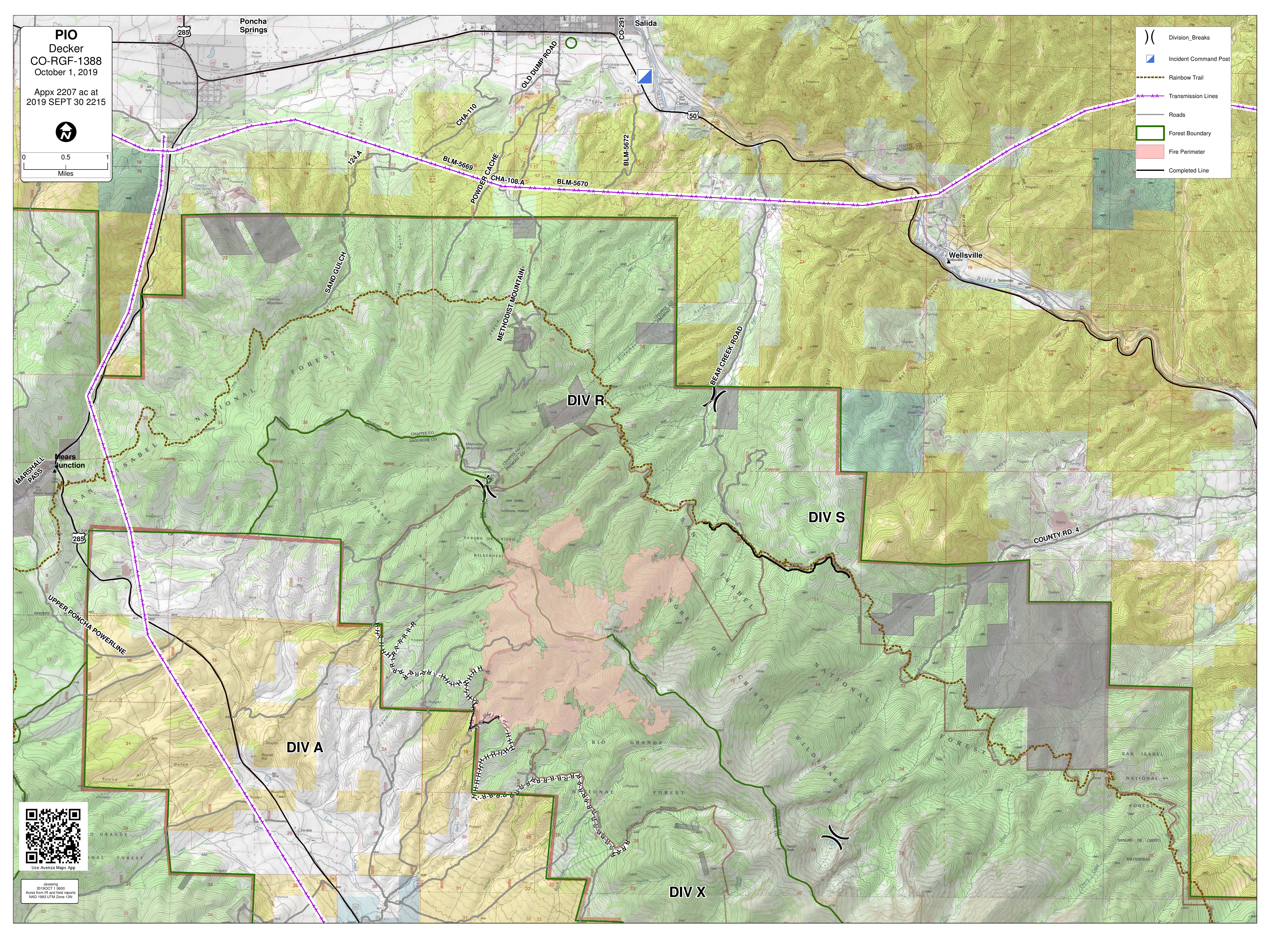
Situación actual: Vientos fuertes contribuyó a la actividad aumentado en el incendio Decker ayer. Humedad densa creció sobre el incendio y podía ser visible desde lejos. En la división S en el lado noreste, el incendio permaneció tranquilo. Entregas de agua desde helicópteros en la mañana ayudó a reducir la extensión al noreste. En la división A en el oeste a las 3pm ayer, la actividad del incendio aumentó considerablemente en un área antes menos activo. Motivado por vientos fuertes en el sur, el incendio quemó en la dirección norte de Green Rocks hasta la cumbre Simmons. Esta área tenia secciones densas de combustibles sin quemado y a veces los largos de los fuegos eran 80 a 100 pies. Una columna de humo largo desarrollado sobre el incendio, y el incendio creció aproximadamente 600 acres. La columna de humo pareció tan largo y densa debido el concentración densa de combustibles caídas y muertas que acumulado a lo largo de los años. Detectaron unas “spot fires,” o fuegos aislados, en la división R en el lado del bosque nacional de San Isabel cercas de los drenajes de Rock y Bear Creek. La mayoría del crecimiento del incendio permanece en dentro de la sierra de Sangre de Cristo. Establecieron un turno de trabajo de noche ayer; dos carros de bomberos y “Task Force Leader,” monitorearon el comportamiento anoche y continuarán serlo como son necesarios.
Hoy es otra día de advertencia de bandera roja con humedad baja (11-16%) y vientos fuertes. Crecimiento es probable hoy, con movimiento probablemente hacia el norte. Humedad densa y columnas son posibles. Helicópteros volarán en la mañana a enfriar áreas de crecimiento de ayer. Se establecerán varios miradores a vigilar crecimiento. Equipos de bomberos en el norte vigilarán para oportunidades para líneas de contingencias afuera de la sierra. Equipos de protección de edificios serán presente en Silver Heels y Bear Creek. A medida que el incendio mueve a la frontera de la sierra y terreno seguro, los bomberos tienen una probabilidad más fuerte de éxito y pueden participar en esfuerzos de represión más agresivos. Los directores del incendio ordenaron más recursos por este objetivo.
La mayoría del incendio es en áreas inaccesibles de las sierra llenas de combustibles caídas y muertas donde es peligroso por bomberos, y donde gotas de agua de helicóptero solo puede reducir y enfriar el incendio. Partes de la sierra puede quemar hasta los combustibles serán completamente consumidos o después de un evento al fin de temporada que puede terminar el incendio como nevadas significativas y sostenidas. Limitando el extensión a tierras privadas y de BLM y garantizar la seguridad de bomberos y la publica permanece las máximas prioridades.
Condiciones climáticas y de combustibles: La recuperación de humedad relativa fue pobre anoche, y hoy espera otro día soleado y seco con humedades desde 11-16%. Temperaturas 53-62F. Vientos de suroeste y sur, 15 a 35mph, con vientos fuertes hasta llegar a 55mph. Vientos de suroeste puede alinear con drenajes desde 12pm y 3pm y después venir del sur a las 3pm. Columnas de humo son probables desde 3pm y 6pm. Espera clima de incendio crítico y vientos altos durante la semana.
Humo: Humo significativo puede permanecer en áreas circundando el incendio. Algunos individuos son más sensibles que otros. Usted debe tomar medidas para protegerse si tienes síntomas. Mas sugerencias se puede encontrar aquí: https://tinyurl.com/ReduceYourSmokeExposure Actualizaciones de humo son disponible en https://tinyurl.com/DeckerFireSmoke. El pronóstico de humo para Salida y el valle del rio de Arakansas se puede encontrar a https://wildlandfiresmoke.net/outlooks/CentralColorado.
Cierres: Partes de caminos 101 y 101A en el bosque nacional y el Rainbow Trail (camino 1336) sur de camino 108 hacia el Stout Lakes Trail (camino 1403) están cerrados. El camino del candado de Chaffee 101/CR 49 (Bear Creek Road) en el candado de Fremont está cerrado (solo abierto por tráfico local). Se ha emitido una restricción de vuelo temporal (TRF) en el área sobre el incendio a permitir operaciones aéreas. Recuerda: si vuelas, vosotros no podemos. No hay evacuaciones en este tiempo.
Por favor no llama 911 a reportar el comportamiento del incendio Decker o pedir información del incendio. Una línea de información del incendio está disponible. Solo llama 911 para emergencias.
Estadísticas del incendio Decker:
Tamaño: 2207 acres, con contención de 5%
Total de personal: 220
Causa: relámpago
Fecha de inicio: 8 de septiembre 2019
Locación: 9 millas de Salida, CO
Información de contacto:
Línea de información del incendio en inglés: (719) 626-1095 (8am-8pm)
Email: 2019.Decker@firenet.gov
InciWeb: inciweb.ncwg.gov/incident/6592
Facebook: Facebook.com/DeckerFire2019
*Translated by Robert Lemus